Hawaii , Kilauea :
HVO/USGS Volcanic Activity Notice
Current Volcano Alert Level: WATCH
Current Aviation Color Code: ORANGE
Issued: Sunday, November 9, 2025, 11:47 AM HST
Source: Hawaiian Volcano Observatory
Notice Number: 2025/H475
Location: N 19 deg 25 min W 155 deg 17 min
Elevation: 4091 ft (1247 m)
Area: Hawaii
During the lapse in appropriations, the USGS Hawaiian Volcano Observatory (HVO) continues to maintain monitoring networks and issue updates and notifications of volcanic activity via the Hazard Notification Service. Volcano monitoring data will continue to be available on the HVO website. Static website content will not be updated until further notice and information may become outdated over time
Volcanic Activity Summary:
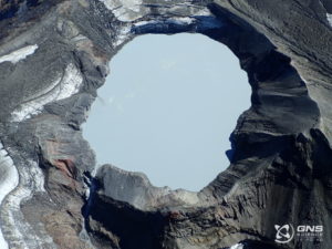
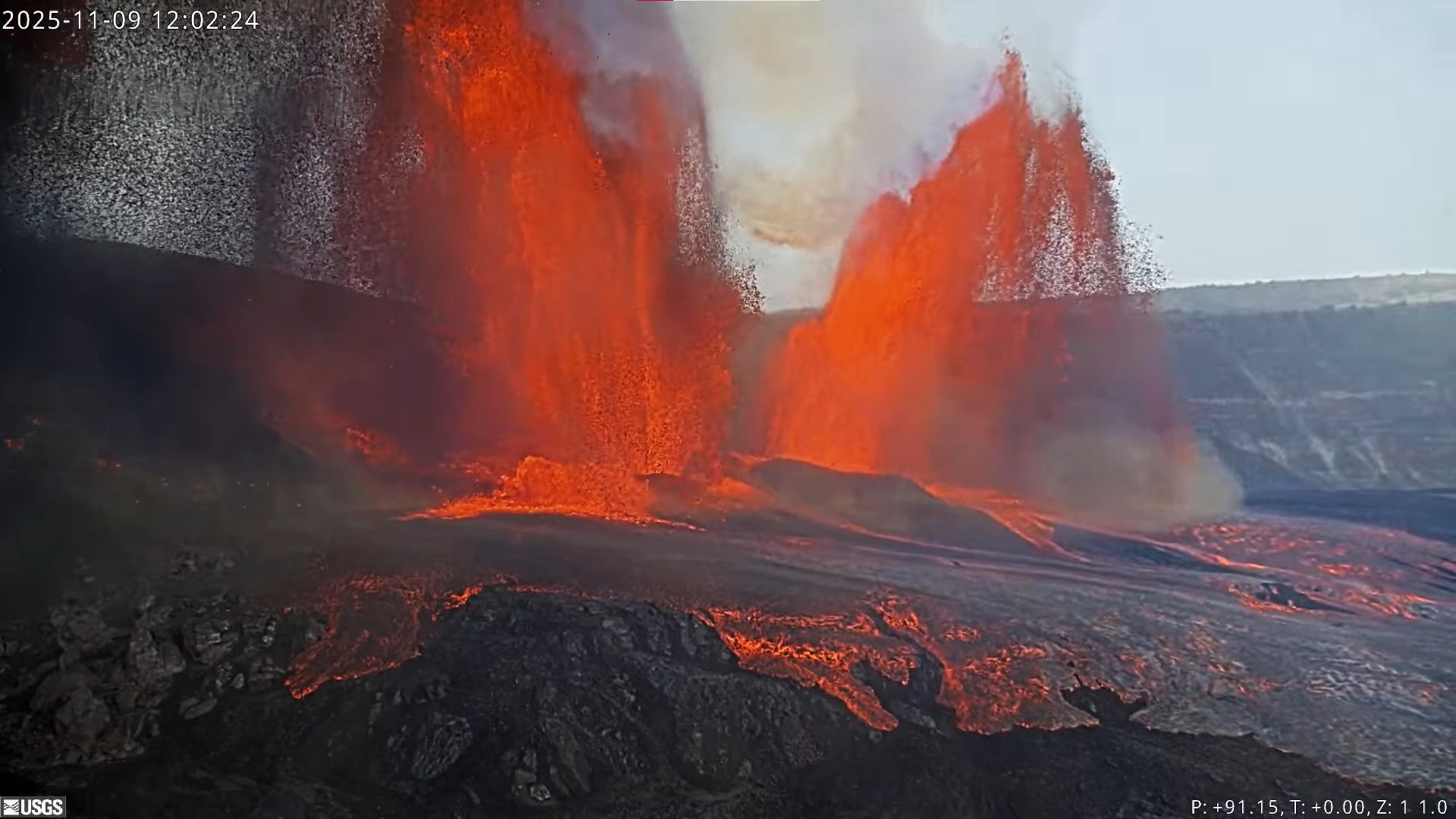
Episode 36 of the ongoing Halemaʻumaʻu eruption began at 11:15 a.m HST on November 9 and is currently fountaining from both the north and south vents.

Past episodes have produced incandescent lava fountains over 1000 feet (300 meters) high that produce eruptive plumes up to 20,000 feet (6000 meters) above ground level. According to the National Weather Service, winds are blowing from the northeast direction, which suggests that volcanic gas emissions and volcanic material may be distributed to the southwest of the summit of Kīlauea..
All eruptive activity is confined to Halemaʻumaʻu crater within Hawaiʻi Volcanoes National Park; commercial airports in Hawaii County (KOA and ITO) will not be affected by this activity.
Episode 36 was preceded by over 180 of lava overflow-drainback events at the north vent beginning on November 3 at 12:46 a.m. HST and at the south vent beginning on November 4 at 1:39 a.m. HST. At 11:15 a.m. HST fountaining began at the to increase dramatically at the north vent and began at the south vent. Currently, fountains from the north vent are about 500 feet (150 meters) high. South vent fountains are about one third as high.
Issued: Sunday, November 9, 2025, 4:29 PM HST
Volcanic Activity Summary:
Episode 36 of the ongoing Halemaʻumaʻu eruption ended abruptly at 4:16 p.m. HST on November 9 after just under 5 hours of continuous fountaining.
The north vent stopped erupting at approximately 3:38 p.m. HST. The south vent dropped from 1000 to 500 feet (300-150 meters) around 3:48 p.m. HST and held steady for a while. The south vent slowly declined and eventually stopped erupting at approximately 4:16 p.m. HST, marking the end of the episode. Lava fountains reached a maximum of 1000-1100 ft (300-330 m) during this episode. The episode 36 fountains lasted for just over 5 hours and produced an estimated 10-11 million cubic yards (8-9 million cubic meters) of lava. The combined average eruption rate was over 650 cubic yards per second (500 cubic meters per second) from the dual fountains, which is the highest effusion rate recorded during this eruption. Lava flows from the fountains covered about 60- 80% of the floor of Halemaʻumaʻu crater.
Volcanic gas emissions have greatly decreased. Lava flows from this episode on the floor of Halemaʻumaʻu within the southern part of Kaluapele (Kīlauea caldera) may continue to exhibit slow movement or incandescence as they cool and solidify over the coming days.
The Uēkahuna tiltmeter (UWD) recorded just over 23 microradians of deflationary tilt during this episode, following the beginning of fountaining at 11:19 a.m this morning. this morning. The end of the eruption was coincident with a flattening of summit tilt and a decrease in seismic tremor intensity. Past episodes have been followed by rapid inflationary tilt, and we expect that change to occur soon.
Source et photo : HVO
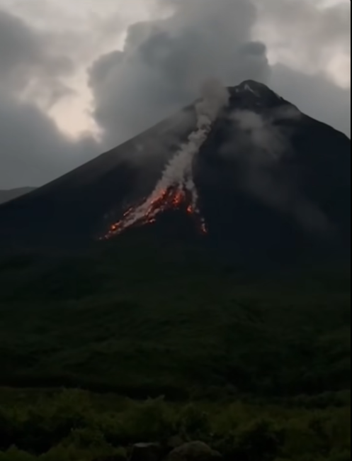
Italy , Stromboli :
STROMBOLI ACTIVITY REPORT November 9, 2025, 12:52 (11:52 UTC)
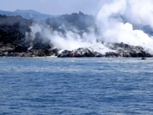
The National Institute of Geophysics and Volcanology, Etna Observatory, reports that analysis of surveillance camera images has revealed, since approximately 10:00 UTC, a lava overflow from the North Crater, feeding a lava flow in the upper part of the Sciara del Fuoco. This overflow is accompanied by moderate but continuous ejection from at least two vents in the North Crater, causing slides of hot material along the Sciara and the formation of clouds of black dust and rolling incandescent blocks. In the South Crater, the usual explosive activity continues.
From a seismic perspective, no significant changes have been observed. Over the past three hours, several small landslides have been recorded along the Sciara del Fuoco, notably at 8:43 and 10:14 UTC. Volcanic tremor has not shown any significant changes in the past few hours.
Analysis of data from ground deformation monitoring networks has revealed no significant changes.
Further information will be released soon.
Source : INGV
Photo : Stromboli stati d’animo / Sebastiano Cannavo
Indonesia , Merapi :
Mount Merapi has once again been the site of pyroclastic avalanches.
Mount Merapi is located on the border between Central Java Province and the Yogyakarta Special Region.
According to data from the Geological Survey, a new pyroclastic avalanche occurred on Sunday, November 9, 2025, at 2:57 PM (Jakarta local time), at an estimated distance of 1,500 meters southwest of the Krasak River. Its maximum amplitude was 37.36 mm and its duration was 104.28 seconds.
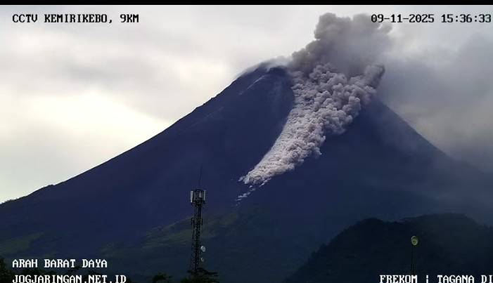
A second avalanche occurred at 3:19 PM (Jakarta local time), at an estimated distance of 1,500 m southwest, upstream of the Krasak River. Its maximum amplitude was 10.32 mm and its duration was 188.56 seconds. Another pyroclastic avalanche occurred at 3:32 PM (Jakarta local time), at an estimated distance of 1,600 m southwest, upstream of the Bebeng and Krasak Rivers. Its maximum amplitude was 27.28 mm and its duration was 184.33 seconds.
At 3:36 PM (Jakarta local time), the eruption was located at an estimated distance of 2,000 m southwest of the Krasak River. Its maximum amplitude was 54.29 mm and its duration was 177.37 seconds.
The current activity level of Mount Merapi is « SIAGA » (level III).
Ecuador , El Reventador :
Special Volcanic Report – El Reventador
Summary
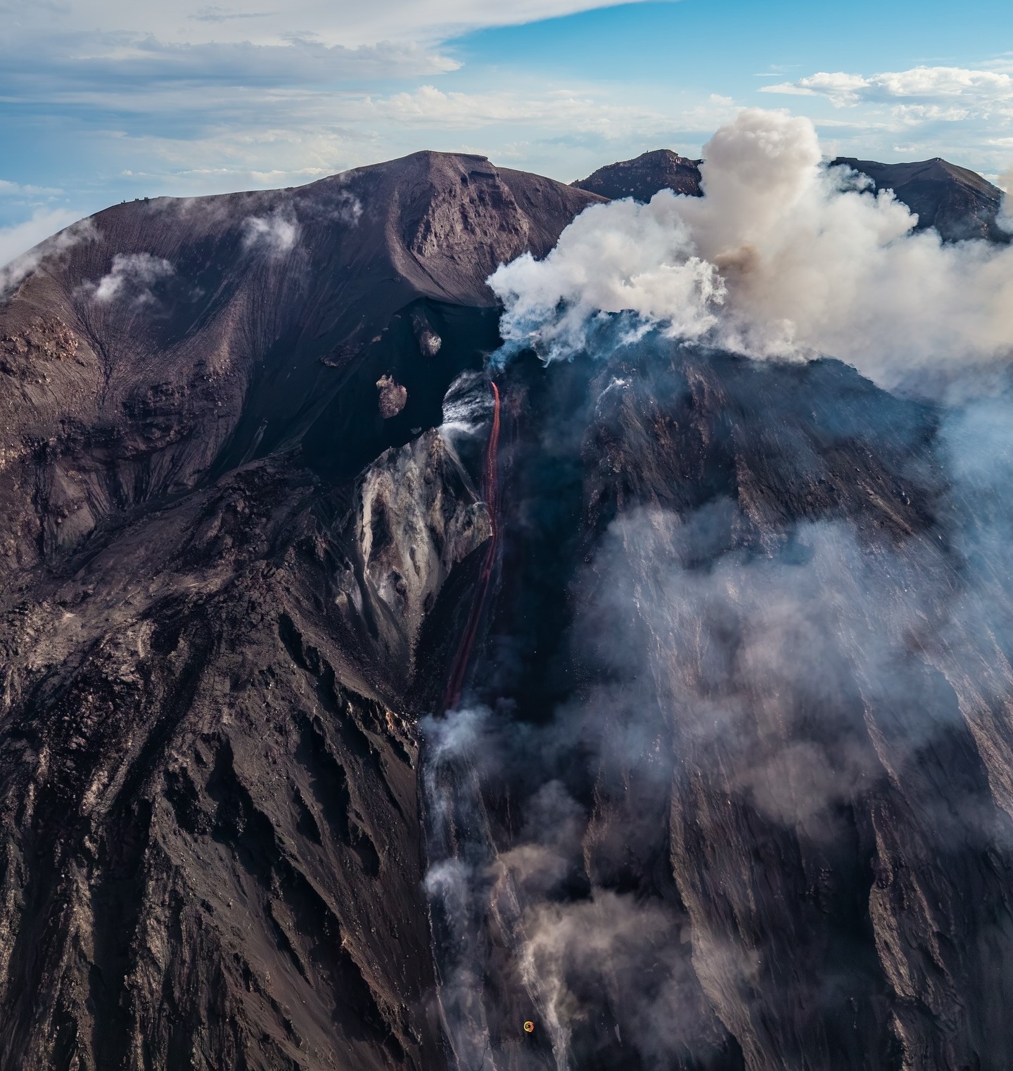
On October 12, 2025, at 6:23 p.m. (local time), monitoring instruments recorded a pyroclastic flow that descended 3.1 km along the eastern flank of El Reventador volcano, reaching an altitude of 1,400 meters below the crater rim. This event was caused by the collapse of the front of a lava flow originating from the volcano’s eastern vent. The pyroclastic flow produced an ash column rising 2.3 km above the crater and generated minor ashfall in the El Chaco Canton, Napo Province.
In the preceding days, a decrease in the daily number of explosions was observed, but an increase in sulfur dioxide (SO₂) emissions, which reached 265.5 tonnes on October 11. The event was accompanied by a tremor signal lasting approximately 50 minutes. Since October 25, a slight increase in the number of explosions and a marked decrease in satellite-measured SO₂ concentrations have been recorded.
In response to these events, a field campaign was conducted on October 14 and 15 to carry out direct measurements and observations, as well as to collect samples from the resulting deposits. Temperature measurements taken using a drone equipped with a thermal camera revealed temperatures exceeding 550 °C in the active craters and the lava flow, while blocks of the pyroclastic flow retained temperatures reaching 370 °C three days after the event.

Infrared images have revealed morphological changes, such as an expansion of the crater and a slight eastward shift in the direction of the lava flow, compared to April 2025, the date of the last field campaign. As of October 15, the lava flow measured 810 m long and 240 m wide, covering an area of 0.12 km² and an estimated volume of 1.1 million m³. The pyroclastic flow, meanwhile, reached a distance of approximately 2,450 meters from the lava front and covered a total area of 0.25 km². These events are relatively modest compared to the 2002 eruption (13.2 km²).
Following this event, internal activity remained moderate, while surface activity remained high. Although the situation has stabilized, the possibility of further pyroclastic flows cannot be ruled out, as the lava flow remains active. Therefore, it is recommended to:
• Avoid approaching the volcano’s flanks.
• Take precautions in case of ashfall.
• Stay away from waterways near the volcano due to the risk of lahars caused by the remobilization of unstable material during rainfall.
The Institute of Geophysics of the National Polytechnic School (IG-EPN) continues to monitor the situation and will issue statements in the event of significant changes in volcanic activity.
Source : IGEPN.
Photos: Guia fotografica / FB , IGEPN.
Kamchatka , Bezymianny :
VOLCANO OBSERVATORY NOTICE FOR AVIATION (VONA)
Issued: November 1 , 20251110/0351Z
Volcano: Bezymianny (CAVW #300250)
Current aviation colour code: ORANGE
Previous aviation colour code: yellow
Source: KVERT
Notice Number: 2025-135
Volcano Location: N 55 deg 58 min E 160 deg 35 min
Area: Kamchatka, Russia
Summit Elevation: 2882 m (9452.96 ft)
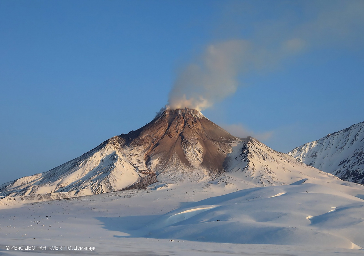
Volcanic Activity Summary:
An effusive activity of the volcano is gradually increasing, this is accompanied by powerful gas-steam emissions and hot avalanches. Satellite data by KVERT showed a large thermal anomaly over the volcano last days with a high value of temperature difference between the thermal anomaly and the background. The volcano is preparing for a strong explosive eruption. KVERT continues to monitor the Bezymianny volcano.
An effusive activity of the Bezymianny volcano is gradually increasing, the volcano is preparing for a strong explosive eruption. Ash explosions up to 10-15 km (32,800-49,200 ft) a.s.l. could occur at any time. Ongoing activity could affect international and low-flying aircrafts.
Volcanic cloud height: NO ASH CLOUD PRODUSED
Other volcanic cloud information: NO ASH CLOUD PRODUSED
Source : Kvert.
Photo : Yu. Demyanchuk, IVS FEB RAS, KVERT ( archive).