November 3 , 2025.
Hawaii , Kilauea :
HAWAIIAN VOLCANO OBSERVATORY DAILY UPDATE , U.S. Geological Survey .
Sunday, November 2, 2025, 9:01 AM HST (Sunday, November 2, 2025, 19:01 UTC)
19°25’16 » N 155°17’13 » W,
Summit Elevation 4091 ft (1247 m)
Current Volcano Alert Level: WATCH
Current Aviation Color Code: ORANGE
During the lapse in appropriations, the USGS Hawaiian Volcano Observatory (HVO) continues to maintain monitoring networks and issue updates and notifications of volcanic activity via the Hazard Notification Service. Volcano monitoring data will continue to be available on the HVO website. Static website content will not be updated until further notice and information may become outdated over time.
Activity Summary:
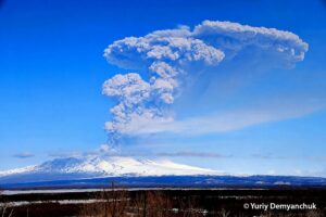
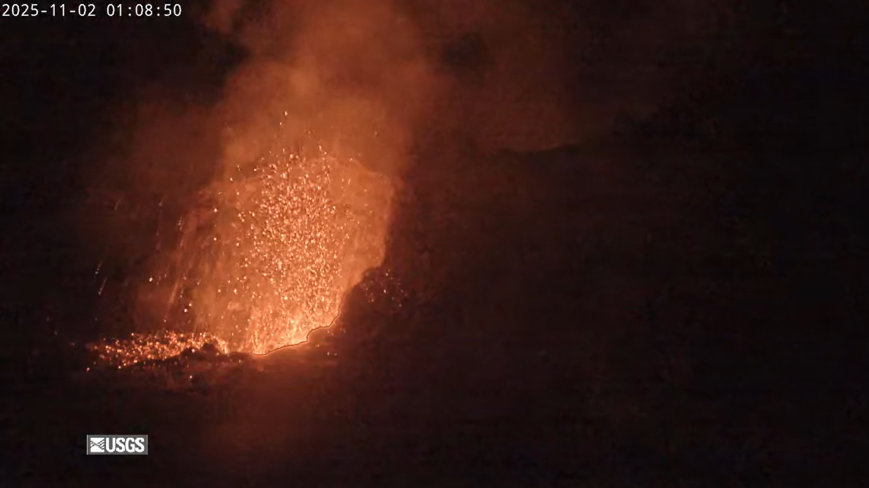
Episode 35 of the ongoing Halemaʻumaʻu eruption ended on October 18 after 7.5 hours of continuous lava fountaining. Both vents continue to exhibit strong incandescence along with minor spattering overnight. Kīlauea summit inflation was relatively minor in the last 24 hours; however, strong vent glow and spatter indicates that magma is high in the vent.. Models suggest a likely forecast window of November 4–8 for episode 36 with November 5-7 most probable.
Summit Observations:
The north and south vents had moderate to strong glow and minor periods of spattering overnight and into the early morning. Plumes of gas were observed at both vents concurrent with strong periods of glow, indicating shallowing of magma in the conduit. One larger gas jetting and spattering event was observed at north vent at 1:08 am HST. (Note: All of the cameras were zoomed in on the vents last night and the infrared filters were turned off on the V2 and V3 making them appear much brighter and white in color.)
The summit continues to inflate. The Uēkahuna tiltmeter (UWD) has recorded approximately 0.5 microradian of inflationary tilt over the past 24 hours and 23.3 microradians of inflationary tilt since the end of episode 35. Tremor patterns consisted of continuous tremor with occasional bursts of stronger tremor signal overnight. These sharp spikes in tremor accompanied the strongest periods of glow and degassing, inferred to represent shallowing of magma in the conduit.
Plumes of gas continue from both vents this morning and sulfur dioxide (SO2) gas emissions remain at background levels, typically between 1,200 and 1,500 tonnes per day.
Source et photo : HVO
Philippines , Kanlaon :
KANLAON VOLCANO LAHAR ADVISORY , 03 November 2025 , 11:30 AM
Based on the Philippine Atmospheric Geophysical and Astronomical Services Administration (PAGASA) Tropical Cyclone Bulletin No. 6 issued at 11:00AM today, 03 November 2025, Severe Tropical Storm “Tino” will potentially bring heavy to intense rainfall over several areas of Central Philippines including Negros Island in the coming days. This can generate volcanic sediment flows or lahars, muddy streamflows or muddy run-off in rivers and drainage areas on Kanlaon Volcano, which is currently at Alert Level 2. DOST-PHIVOLCS thus strongly recommends increased vigilance and readiness of communities in pre-determined zones of lahar and related hazards on this volcano.

Prolonged and heavy rainfall may generate generally channel-confined post-eruption lahars and sediment-laden streamflows on major channels draining the southern and western slopes of Kanlaon Volcano. These flows can be generated by intense rainfall eroding loose material from remnant pyroclastic density current (PDC) deposits of the 24 October 2025 explosive eruption and loose ashfall from this as well as from recent ash emission events. In particular, potentially hot lahars and sediment-laden streamflows may occur along the Tamburong/Ibid Creek in Biak-na-Bato and Baji-Baji Falls and Talaptapan Creek in Cabacungan, La Castellana, Negros Occidental, drainages that are headed on gullies covered by recent PDC deposits. Communities along and downstream of channels on the southern and western slopes are advised to be prepared in case evacuation becomes necessary and to avoid traversing affected streams even those farther downslope of the volcano.
DOST-PHIVOLCS is monitoring volcanic unrest in Kanlaon Volcano 24/7 and any new development will be communicated immediately to the public.
Source et photo : DOST-PHIVOLCS
Chile , Planchón-Peteroa :
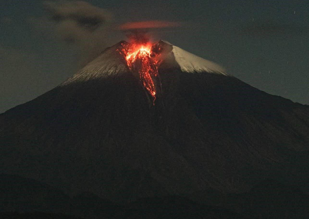
Special Volcanic Activity Report (REAV), Maule Region, Planchón-Peteroa Volcanic Complex
November 2, 2025, 12:53 PM local time (Mainland Chile)
The Chilean National Geological and Mining Service (Sernageomin) publishes the following PRELIMINARY information, obtained through monitoring equipment from the National Volcanic Monitoring Network (RNVV), processed and analyzed at the Southern Andes Volcanological Observatory (OVDAS):
On Sunday, November 2, at 2:57 PM UTC, images from monitoring cameras installed near the Planchón-Peteroa Volcanic Complex revealed a column of gas and pyroclastic material reaching 920 meters in height above the crater, dispersing in a southeasterly direction.

Image from the Guamparo surveillance camera, dated November 2, 2025, at 2:57 PM UTC (11:57 AM CET).
Based on the latest activity reports published by SERNAGEOMIN concerning this volcano, and considering the above, the possibility of further episodes of similar or greater energy, and/or low- to medium-magnitude explosions affecting the immediate vicinity of the active craters, cannot be ruled out.
OBSERVATIONS: As of the date of publication of this report, seismic activity shows no other significant changes.
The volcanic alert level remains: YELLOW Technical Alert.
Source et photo : Sernageomin.
Indonesia , Ili Lewotolok :
The activity level of Ili Lewotolok volcano was raised from Level III (SIAGA) to Level II (WASPADA) on November 2, 2025, at 9:00 AM WITA.
On July 2, 2025, the activity level of Mount Ili Lewotolok, located in Lembata Regency, East Nusa Tenggara Province, was raised to Level III (SIAGA) due to increased eruptive activity. Following this reassessment, the intensity of eruptions at Mount Ili Lewotolok has gradually decreased, particularly in terms of the number of eruptions, the height of the eruptive column, the distance of the ejected material, and the associated rumbling and detonating sounds.
Seismic data from the last week, October 23-31, 2025, recorded 709 eruptive earthquakes, 1,615 emission earthquakes, 5 harmonic tremors, 4 non-harmonic tremors, 20 deep volcanic earthquakes, 2 local tectonic earthquakes, and 31 distant tectonic earthquakes. One earthquake of magnitude IV on the MMI scale was recorded.

The volcano was perfectly visible, even shrouded in fog. A grayish-white smoke rose from the crater, varying in intensity, between 20 and 600 meters above the summit. The grayish-white eruptive column extended between 100 and 300 meters above the summit. Incandescent material, ejected during the eruption, fell back into the crater area. Rumbling sounds could still be heard, but were generally faint.
Following visual and instrumental observations, the activity level of Mount Ili Lewotolok has been lowered from Level III (SIAGA) to Level II (WASPADA), effective November 2, 2025, at 9:00 AM WITA (Central Indonesian Time), with the following recommendations:
Communities living near Mount Ili Lewotolok, as well as visitors, climbers, and tourists, are advised to refrain from all activities within a 2 km radius of the Mount Ili Lewotolok activity center, and within a 2.5 km radius of this center in the south-southeast and west sectors. They should be aware of the risk of lava avalanches and pyroclastic flows in the south, southeast, west, and northeast sectors of Mount Ili Lewotolok. The public is advised not to panic if rumbling or detonating sounds are heard from the crater of Mount Ili Lewotolok, as these noises are characteristic of volcanic activity during an eruptive phase.
Source : PVMBG.
Ecuador , Sangay :
DAILY REPORT ON THE STATE OF SANGAY VOLCANO, Sunday, November 2, 2025.
Geophysical Information Institute – EPN.
Surface Activity Level: Moderate, Surface Trend: No Change
Internal Activity Level: Moderate, Internal Trend: No Change
Seismicity: From November 1, 2025, 11:00 AM to November 2, 2025, 11:00 AM:
Seismicity:
Below is the count of seismic events recorded at the reference station:
Explosion (EXP): 128
Rainfall/Lahars:
No rain has been recorded in the volcanic zone. **Heavy rainfall could remobilize accumulated material, generating mudflows and debris flows that would cascade down the volcano’s flanks and flow into adjacent rivers.**
Emission Column/Ash:
Since yesterday afternoon, several gas and ash emissions have been observed by the monitoring camera network and the GOES-19 satellite. These emissions are reaching an altitude of between 800 and 1,200 meters above the crater and are drifting west, southwest, and west-northwest. In this regard, the VAAC agency in Washington has published two reports indicating emissions reaching an altitude of between 900 and 1,200 meters above the crater and drifting westward.
Gas:
The Mounts system detected 40.30 tonnes of sulfur dioxide (SO₂), measured at 2:26 p.m. local time on November 1, 2025.
Other monitoring parameters:
The FIRMS satellite system detected two thermal anomalies, the MIROVA-MODIS system one thermal anomaly, and the MIROVA-VIIRS system three thermal anomalies.
Observation:
Overnight and early this morning, incandescence was observed at the crater by the network of monitoring cameras. At the time of writing, the volcano remains shrouded in clouds.
Alert level: Yellow
Source : IGEPN
Photo : Cristopher Cárdenas , 12/06/2025 / FB.