October 24 , 2025.
Colombia , Nevado del Ruiz :
Manizales, October 21, 2025, 5:50 p.m.
Regarding the monitoring of the activity of the Nevado del Ruiz volcano, the Colombian Geological Survey (SGC), an entity attached to the Ministry of Mines and Energy, reports that:
During the week of October 14 to 20, 2025, the volcano continued to exhibit unstable behavior. The main variations in the monitored parameters compared to the previous week were:
– Seismic activity associated with rock fracturing processes within the volcanic edifice increased, with an increase in the number of recorded earthquakes and the seismic energy released. The events were located mainly on the east-northeast and northeastern flanks, less than 2 km from the Arenas crater and at depths between 2 km and 4 km from the volcano’s summit. To a lesser extent, earthquakes were recorded in the Arenas crater (depths less than 2 km) and, scattered across the other flanks of the volcano, at distances of up to 10 km from the crater and at depths ranging from less than 1 km to 8 km.
On October 16, a seismic wave occurred in the northeast sector of the volcano, during which the largest number of events of the week was recorded, as well as the strongest earthquake (magnitude 2.0). This last event corresponds to the one recorded at 11:43, located 2 km east-northeast of the volcanic structure and at a depth of 4 km.

– Seismicity associated with fluid dynamics in volcanic conduits maintained similar levels in terms of the number of recorded earthquakes and decreased in terms of released seismic energy. The energy levels of the seismic events were low. Thanks to the cameras (conventional or thermographic) used to monitor the volcano and reports from officials of the Los Nevados National Natural Park (PNN), several pulsed ash emissions and variations in the apparent temperature of the emitted materials were confirmed.
– The volcano continued to emit variable amounts of water vapor and volcanic gases, mainly sulfur dioxide (SO₂), into the atmosphere. Estimated values of the SO₂ flux associated with degassing processes were similar to those obtained the previous week. This trend was confirmed by satellite monitoring of this parameter.
– The maximum height of the water vapor, gas, or ash column was 1,100 m vertically and 1,300 m dispersed. These values were measured above the volcano’s summit during the ash emission on October 17 at 8:23 p.m. Regarding the dispersion direction, the plume showed a preferential trend toward the west-northwest and west-southwest flanks of the volcano and, to a lesser extent, toward the east-northeast and east-southeast. National park officials received reports of ashfall from the Valle de las Tumbas sector on October 20.
– During the monitoring of thermal anomalies at the floor of the Arenas crater using satellite monitoring platforms, low-energy anomalies were reported.
It should be noted that detection remained limited by the persistence of atmospheric conditions with high cloud cover in the area.
Source et photo : SGC
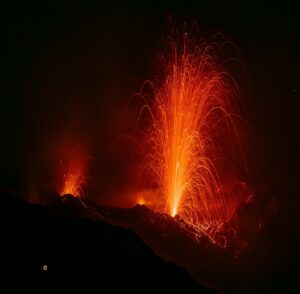
Indonesia , Semeru :
VOLCANO OBSERVATORY NOTICE FOR AVIATION – VONA
Issued : October 23 , 2025
Volcano : Semeru (263300)
Current Aviation Colour Code : ORANGE
Previous Aviation Colour Code : orange
Source : Semeru Volcano Observatory
Notice Number : 2025SMR3165
Volcano Location : S 08 deg 06 min 29 sec E 112 deg 55 min 12 sec
Area : East java, Indonesia
Summit Elevation : 11763 FT (3676 M)
Volcanic Activity Summary :
Eruption with volcanic ash cloud at 22h42 UTC (05h42 local).

Volcanic Cloud Height :
Best estimate of ash-cloud top is around 14003 FT (4376 M) above sea level or 2240 FT (700 M) above summit. May be higher than what can be observed clearly. Source of height data: ground observer.
Other Volcanic Cloud Information :
Ash cloud moving to west. Volcanic ash is observed to be gray. The intensity of volcanic ash is observed to be medium.
Remarks :
Eruption recorded on seismogram with maximum amplitude 22 mm and maximum duration 123 second.
Seismic Observations
61 eruption earthquakes with amplitudes ranging from 10 to 22 mm and durations ranging from 68 to 187 seconds.
11 avalanche earthquakes with amplitudes ranging from 2 to 6 mm and durations ranging from 35 to 101 seconds.
19 emission earthquakes with amplitudes ranging from 2 to 8 mm and durations ranging from 37 to 78 seconds.
2 distant tectonic earthquakes with amplitudes ranging from 32 to 40 mm and durations ranging from 81 to 139 seconds.
1 lahar earthquake with amplitude of 15 mm and duration of 5,483 seconds.
Source : PVMBG
Photo : Oystein Lund Andersen ( archive 2021)
Alaska , Shishaldin :
54°45’19 » N 163°58’16 » W,
Summit Elevation 9373 ft (2857 m)
Current Volcano Alert Level: ADVISORY
Current Aviation Color Code: YELLOW
Frequent small earthquakes and infrasound signals were detected over the past day. Satellite and webcam views of the volcano were cloudy, but sulfur dioxide emissions possibly originating at Shishaldin Volcano were observed in satellite data.
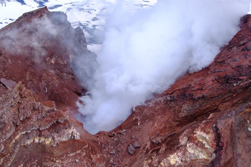
View of the degassing summit vent of Shishaldin Volcano on August 22, 2025. Top of the image is east.
Local seismic and infrasound sensors, web cameras, and a geodetic network are used to monitor Shishaldin Volcano. In addition to the local monitoring network, AVO uses nearby geophysical networks, regional infrasound and lighting data, and satellite images to detect eruptions.
Shishaldin Volcano, located near the center of Unimak Island in the eastern Aleutian Islands, is a conical stratovolcano with a base approximately 16 km in diameter. It is one of the most active volcanoes in the Aleutian volcanic arc, with at least 54 episodes of unrest, including more than 28 confirmed eruptions since 1824. Most eruptions are relatively small, although activity from July to November 2023 generated ash columns reaching between 9 and 13 km in height.
Source : AVO
Photo : Loewen, Matt / Alaska Volcano Observatory / U.S. Geological Survey .
Peru , Sabancaya :
Summary:
The IGP reports that the Sabancaya volcano continues its eruption process. During this period, no volcanic explosions have been recorded; however, emissions of water vapor and gas have been observed, reaching a maximum height of 1,100 m above the volcano’s summit.
In addition to seismic activity associated with the movement of magmatic fluids and internal fracturing, the volcano’s alert level remains orange.

Analysis
123 earthquakes were identified, associated with the circulation of magmatic fluids within the volcano, as well as earthquakes related to rock fracturing. No volcanic explosions occurred during this period.
Columns of water vapor and gas were observed, reaching up to 1,100 m above the volcano’s summit.
These products were predominantly dispersed toward the northern and western sectors of the volcano. The affected radius was less than 10 km.
No significant deformation was recorded within the volcanic edifice.
Low sulfur dioxide (SO2) emissions were observed, averaging 156 tons per day.
In addition, eight thermal anomalies of less than 1 MW were detected, associated with the proximity of a magmatic body to the crater surface.
Outlook
Future volcanic explosions generating eruptive columns over 2 km high are considered likely, with a potential impact on the districts of the Colca Valley and surrounding areas through the dispersal of volcanic ash. Therefore, the Volcanic Alert Level remains orange.
Between October 20 and 22, if ash emissions occur, they would disperse towards the northeast and north sectors of the volcano. From October 23 to 26, they would disperse towards the southeast and east sectors of Sabancaya, with winds of 50 km/h.
SENAMHI predicts rains between October 22 and 24, 2025, which could generate lahars in the vicinity of the volcano.
Source : Cenvul
Photo : Zintia Roxana Fernández Licla
Kamchatka , Krasheninnikov :
VOLCANO OBSERVATORY NOTICE FOR AVIATION (VONA)
Issued: October 24 , 2025
Volcano: Krasheninnikov (CAVW #300190)
Current aviation colour code: ORANGE
Previous aviation colour code: orange
Source: KVERT
Notice Number: 2025-123
Volcano Location: N 54 deg 35 min E 160 deg 16 min
Area: Kamchatka, Russia
Summit Elevation: 1856 m (6087.68 ft)
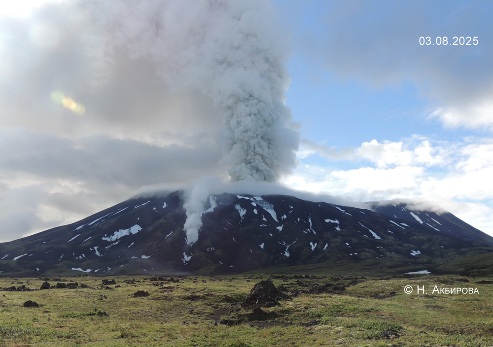
Volcanic Activity Summary:
A moderate emission of ash from the volcano continues. Explosions sent ash up to 2.5 km a.s.l., and ash plume is extending for 50 km to the south-east of the volcano.
An explosive-effusive eruption of the volcano continues. The danger of ash explosions up to 6 km (19,700 ft) a.s.l. remains. Ongoing activity could affect low-flying aircraft.
Volcanic cloud height:
2000-2500 m (6560-8200 ft) AMSL Time and method of ash plume/cloud height determination: 20251024/0301Z – MODIS AQUA 31m32
Other volcanic cloud information:
Distance of ash plume/cloud of the volcano: 50 km (31 mi)
Direction of drift of ash plume/cloud of the volcano: SE / azimuth 127 deg
Time and method of ash plume/cloud determination: 20251024/0301Z – MODIS AQUA 31m32
Remarks:
The first historical eruption of the volcano began on 02 August, 2025. The explosive-effusive eruption of the volcano continues. The previous effusive eruption of the volcano occurred 400-600 years ago. In 1963, fumarole activity was noted in the crater of the middle Northern cone.
Source : Kvert
Photo : N. Akbirova – IVS FEB RAS KVERT ( 2025)