October 15, 2025
Italy , Stromboli :
WEEKLY BULLETIN, from October 6, 2025 to October 12, 2025. (Publication date: October 14, 2025)
ACTIVITY SUMMARY
Based on monitoring data, the following points should be noted:
1) VOLCANOLOGICAL OBSERVATIONS: During this period, Strombolian-type eruptive activity was observed. The total hourly frequency ranged from medium (9 events/h) to high (17 events/h). The intensity of the explosions was low and medium in the northern area of the crater, and low to high in the central-southern area of the crater.
2) SEISMOLOGY: The monitored seismic parameters showed no significant variation.
3) GROUND DEFORMATION: The ground deformation monitoring networks showed no significant variation. 4) GEOCHEMISTRY: SO2 flux at an average level.
Soil CO2 flux in the Pizzo region (STR02): No update.
C/S ratio in the plume: No update. The most recent data were average (September 9).
Helium isotope ratio (R/Ra): No update.
Soil CO2 flux in the San Bartolo region: Average values.
Soil CO2 flux in the Scari region: High values.
5) SATELLITE OBSERVATIONS: Thermal activity observed by satellite in the summit area was generally low, with some isolated thermal anomalies of moderate intensity.
VOLCANOLOGICAL OBSERVATIONS
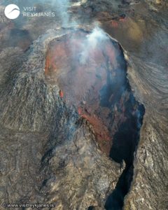
During the observation period, Stromboli’s eruptive activity was characterized by analyzing images recorded by INGV-OE surveillance cameras located at 190 m (SCT-SCV) and at Punta dei Corvi (SPCT). Explosive activity was mainly produced by five eruptive vents located in the North (N) crater area and at least two vents in the Center-South (CS) area.
Observations of explosive activity captured by surveillance cameras
Five active vents were observed in the North crater area, two in the N1 sector, and three in the N2 sector. They produced low-intensity explosive activity (less than 80 m high) and sometimes medium-intensity explosive activity (less than 150 m high). The eruptive products were mainly coarse materials (bombs and lapilli). The average explosion frequency ranged from 9 to 14 events per hour.
Two main vents were observed in the south-central area of the crater, exhibiting low- to high-intensity fine-material explosions and coarse-material explosions, respectively. The average explosion frequency was approximately 3 events per hour.
Source : INGV
Photo : Stromboli stati d’animo / Sebastiano Cannavo
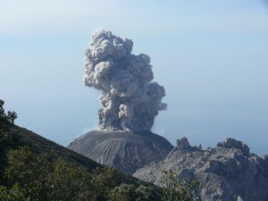
Indonesia , Lewotobi Laki-laki :
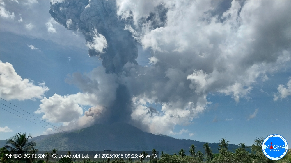
An eruption occurred at Mount Lewotobi Laki-laki on Wednesday, October 15, 2025, at 9:21 a.m. (local time). An ash column was observed about 8,000 m above the summit (about 9,584 m a.s.l.). The ash column was gray and dense, oriented north and northwest. At the time of writing, the eruption was still ongoing.
VOLCANO OBSERVATORY NOTICE FOR AVIATION – VONA
Issued : October 15 , 2025
Volcano : Lewotobi Laki-laki (264180)
Current Aviation Colour Code : RED
Previous Aviation Colour Code : red
Source : Lewotobi Laki-laki Volcano Observatory
Notice Number : 2025LWK487
Volcano Location : S 08 deg 32 min 20 sec E 122 deg 46 min 06 sec
Area : East Nusa Tenggara, Indonesia
Summit Elevation : 5069 FT (1584 M)
Volcanic Activity Summary :
Eruption with volcanic ash cloud at 00h35 UTC (08h35 local).
Volcanic Cloud Height :
Best estimate of ash-cloud top is around 30669 FT (9584 M) above sea level or 25600 FT (8000 M) above summit. May be higher than what can be observed clearly. Source of height data: ground observer.
Other Volcanic Cloud Information :
Ash cloud moving from north to northwest. Volcanic ash is observed to be gray. The intensity of volcanic ash is observed to be thick.
Remarks :
Eruption and ash emission is continuing. Eruption recorded on seismogram with maximum amplitude 47.3 mm.
Source et photo : PVMBG
Italy / Sicily , Etna :
WEEKLY BULLETIN, from October 6, 2025 to October 12, 2025. (Publication date: October 14, 2025)
ACTIVITY SUMMARY
In light of the monitoring data, the following points should be noted:
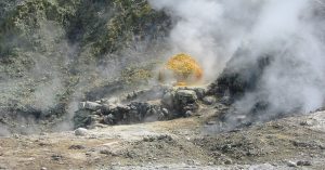
1) VOLCANOLOGICAL OBSERVATIONS: Variable degassing rates in the summit craters.
2) SEISMOLOGY: Low seismic activity due to fracturing. Medium-level tremor amplitude.
3) INFRASOUND: Moderate infrasound activity.
4) GROUND DEFORMATION: Ground deformation monitoring networks did not measure any significant variations.
5) GEOCHEMISTRY: Medium-level SO2 fluxes
Soil-derived CO2 fluxes (EtnaGas Network): Low values.
Partial pressure of dissolved CO2 in groundwater (EtnaWater Network): No update.
Helium isotope ratio (R/Ra) at peripheral sites: The latest data from September 22 are high.
6) SATELLITE OBSERVATIONS: Thermal activity observed by satellite in the summit area was generally low.
VOLCANOLOGICAL OBSERVATIONS
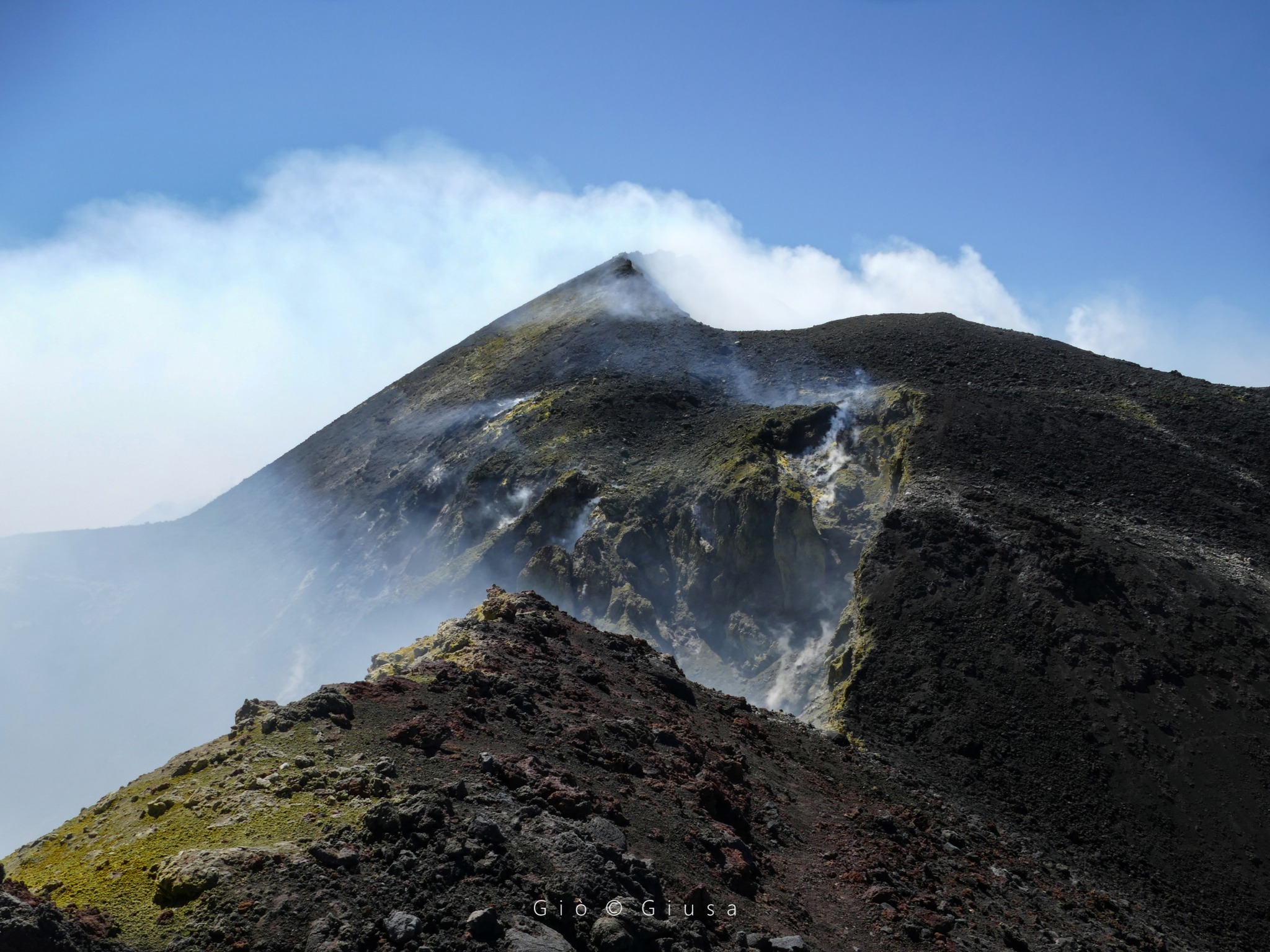
During the week, Mount Etna’s volcanic activity was monitored through the analysis of images from the INGV Etneo Observatory (INGV-OE) surveillance cameras. Due to adverse weather conditions, observation of volcanic activity by the cameras was very limited and intermittent.
On days with good visibility, the activity affecting the summit craters was mainly degassing.
SEISMOLOGY:
Earthquakes: During the week in question, only one event reached the magnitude 2 threshold. The earthquake in question, with a magnitude of 2.0, was recorded on the 8th at 01:28 UTC and was located on the northwest flank of the volcano (1.5 km northeast of Mount Lepre), at a depth of approximately 29 km below sea level.
Volcanic Tremor: The average amplitude of volcanic tremor throughout the week remained mostly within the average range. The center of gravity of the tremor sources was located in the northeast crater area, at a depth between 1,700 and 2,900 meters above sea level.
Source : INGV
Photo : Gio Giusa.
Iceland , Reykjanes Peninsula:
Hazard assessment unchanged
Brief micro-earthquake swarm east of Sýlingarfell last Saturday
Updated 14 October 2025
Key points
A brief micro-earthquake swarm occurred east of Sýlingarfell on Saturday evening.
Deformation measurements over recent weeks indicate that uplift and magma accumulation continue beneath Svartsengi.
There remains considerable uncertainty about the timing of the next event.
The current hazard assessment remains unchanged and is valid for two weeks, unless activity increases.
Current situation
A short-lived micro-earthquake swarm was recorded east of Sýlingarfell on Saturday evening. The activity lasted about one hour before subsiding. No significant changes were observed in GPS measurements, fibre-optic strain data, or borehole pressure in Svartsengi during the swarm.
Similar micro-earthquake swarms have been observed a few weeks before previous eruptions along the Sundhnúkur crater row, such as those in May and November 2024. Increased seismic activity of this type indicates rising pressure in the magma accumulation zone, though the exact timing of the next event remains uncertain.
Deformation measurements
Deformation measurements in recent weeks show that uplift and magma accumulation continue beneath Svartsengi.
When looking at the rate of uplift over several weeks, there are indications that the rate has slowed slightly.
Since the last eruption, which began on 16 July, between 12 and 13 million cubic metres of magma are estimated to have re-accumulated beneath the Svartsengi magma storage area.
Based on previous events along the Sundhnúkur crater row, the likelihood of a new magma intrusion or eruption increases once a similar amount of magma has accumulated as was released in the last event. The volume of magma that left the system during that eruption is estimated at 11–13 million cubic metres, and the lower limit of that range was reached around the turn of the month.
Analysis of previous events has enabled the Icelandic Meteorological Office to estimate the range of accumulated magma volumes that could trigger the next intrusion or eruption.
The upper limit of that range is estimated at about 23 million cubic metres, which, according to model calculations, would be reached by late December, assuming the current accumulation rate remains steady.
There is therefore still considerable uncertainty regarding the timing of the next event.
Seismic activity and subsidence near Krýsuvík
Seismic activity continues near Krýsuvík, with numerous small earthquakes detected daily.
Ground subsidence also continues in the area, amounting to approximately 50 mm at the Móhálsadalur GPS station since early June.
Source et photo : IMO.
Kamchatka , Klyuchevskoy :
VOLCANO OBSERVATORY NOTICE FOR AVIATION (VONA)
Issued: October 14 , 2025
Volcano: Klyuchevskoy (CAVW #300260)
Current aviation colour code: ORANGE
Previous aviation colour code: orange
Source: KVERT
Notice Number: 2025-115
Volcano Location: N 56 deg 3 min E 160 deg 38 min
Area: Kamchatka, Russia
Summit Elevation: 4750 m (15580 ft)

Volcanic Activity Summary:
The explosive eruption of the volcano continues. Explosions send ash up to 7.5 km a.s.l., and gas-steam plume with some amount of ash is extending for 80 km to the north-northeast of the volcano. The common plume is extending to the northeast, and onwards to the east, and to the southeast. The edge of the ash plume is noting at 2110 km to the southeast of the volcano.
The explosive eruption of the volcano continues. The danger of ash explosions up to 10 km (32,800 ft) a.s.l. remains. Ongoing activity could affect international and low-flying aircraft.
Volcanic cloud height:
7200-7500 m (23616-24600 ft) AMSL Time and method of ash plume/cloud height determination: 20251014/2110Z – Himawari-9 14m15
Other volcanic cloud information:
Distance of ash plume/cloud of the volcano: 80 km (50 mi)
Direction of drift of ash plume/cloud of the volcano: NNE / azimuth 29 deg
Time and method of ash plume/cloud determination: 20251014/2110Z – Himawari-9 14m15
Source : Kvert
Photo : Vulcanyia ( archive)