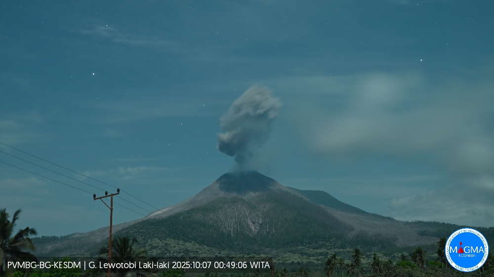
October 7 , 2025.
Indonesia , Lewotobi Laki-laki :
An eruption of Mount Lewotobi Laki-laki occurred on Tuesday, October 7, 2025, at 00:49 WITA. The observed ash column was ± 2,000 m above the summit (± 3,584 m above sea level). The ash column was gray and of strong intensity, oriented towards the West and Northwest. This eruption was recorded by seismograph with a maximum amplitude of 14.8 mm and a duration of 170 seconds.
VOLCANO OBSERVATORY NOTICE FOR AVIATION – VONA
Issued : October 7 , 2025
Volcano : Lewotobi Laki-laki (264180)
Current Aviation Colour Code : ORANGE
Previous Aviation Colour Code : orange
Source : Lewotobi Laki-laki Volcano Observatory
Notice Number : 2025LWK481
Volcano Location : S 08 deg 32 min 20 sec E 122 deg 46 min 06 sec
Area : East Nusa Tenggara, Indonesia
Summit Elevation : 5069 FT (1584 M)
Volcanic Activity Summary :
Eruption with volcanic ash cloud at 16h49 UTC (00h49 local).
Volcanic Cloud Height :
Best estimate of ash-cloud top is around 11469 FT (3584 M) above sea level or 6400 FT (2000 M) above summit. May be higher than what can be observed clearly. Source of height data: ground observer.
Other Volcanic Cloud Information :
Ash cloud moving from west to northwest. Volcanic ash is observed to be gray. The intensity of volcanic ash is observed to be thick.
Remarks :
Eruption recorded on seismogram with maximum amplitude 14.8 mm and maximum duration 170 second.
Source et photo : Magma Indonésie .
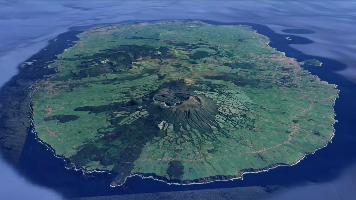
Azores , Terceira :
The Crisis Bureau met in September to assess seismic activity.
At its September meeting on seismic activity, the Crisis Bureau maintained the volcanic alert levels, with the exception of the West Terceira volcanic fissure system.
On Terceira Island, seismic activity, although low in magnitude, remained significantly above reference levels, particularly at the Santa Bárbara volcano and in the West Terceira fissure system. Seismic activity was also recorded in the area between Cinco Ribeiras and Angra do Heroísmo. The most powerful event reached a magnitude of 3.1 and was felt in the western sector of the island, with a maximum intensity of V on the Modified Mercalli scale. September recorded the strongest seismic activity of 2025.
During the same period, although not very intense, some crustal deformation continued to be recorded in the area of the Santa Bárbara volcano, which, in 2025, began to extend to the fissure volcanic system. No gas anomalies likely to be related to the current seismovolcanic crisis were observed.
Therefore, the Crisis Office decided to maintain the V2 alert for the Santa Bárbara volcano and raised the alert level from V1 to V2 for the West Terceira Fissural Volcanic System, taking into account crustal deformation data.
Seismic activity on São Jorge Island and adjacent structures, particularly in the Rosais region, remains slightly above reference levels; the V1 alert therefore remains in effect.
Source : IVAR.
Photo : Google maps
Hawaii , Kilauea :
HAWAIIAN VOLCANO OBSERVATORY DAILY UPDATE , U.S. Geological Survey
Monday, October 6, 2025, 8:41 AM HST (Monday, October 6, 2025, 18:41 UTC)
19°25’16 » N 155°17’13 » W,
Summit Elevation 4091 ft (1247 m)
Current Volcano Alert Level: WATCH
Current Aviation Color Code: ORANGE
Activity Summary:
Episode 34 lava fountaining ended October 1 at 7:03 a.m. HST after approximately 6 hours of continuous activity. Variable weak to moderate incandescence was visible from both cones last night and the rhythmic pattern of seismic tremor indicates gas piston events in both vents. Kīlauea’s summit region resumed inflation following the end of episode 34, indicating that another fountaining episode is likely to start between October 15 and 20.
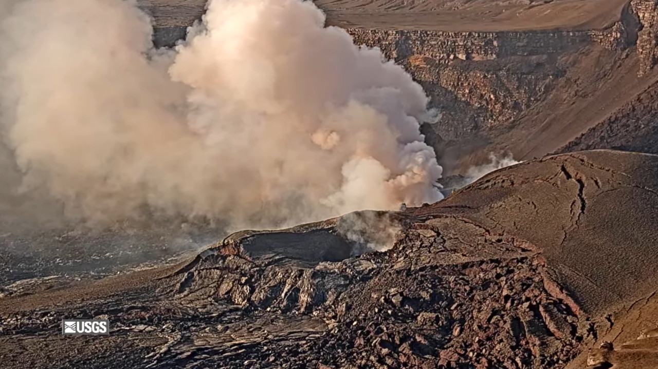
Summit Observations:
The caldera this morning has been quiet with a passively outgassing plume rising from the vents after the end of episode 34. Last night, both the north and south vents showed weak to moderate glow that was rhythmic. The variable nature of the glow correlates with spikes in seismic tremor 10–15 minutes apart, which are indicative of gas piston activity within both vents. The UWD tiltmeter shows that inflationary tilt has resumed since the end of episode 34 and has rapidly recovered approximately 11.4 microradians so far.
Source et photo : HVO.
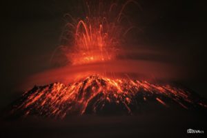
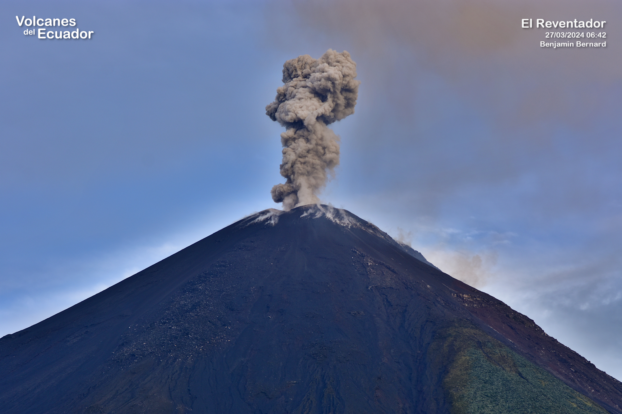
Ecuador , El Reventador :
DAILY STATUS REPORT OF REVENTADOR VOLCANO, Monday, October 6, 2025.
Information Geophysical Institute – EPN.
Surface Activity Level: High, Surface Trend: No change
Internal Activity Level: Moderate, Internal Trend: No change
From October 5, 2025, 11:00 a.m. to October 6, 2025, 11:00 a.m.:
Seismicity:
Below is the count of seismic events recorded at the reference station.
Explosion (EXP) 76
Long Period (LP) 11
Emission Tremor (TREMI) 4
Harmonic Tremor (TRARM) 4
Rainfall/Lahars:
Precipitation was recorded in the volcanic area without generating mudflows or debris flows. **In the event of heavy rainfall, this could remobilize accumulated material, generating mudflows and debris flows that would cascade down the volcano’s flanks and flow into adjacent rivers.**
Emission/Ash Column:
From yesterday afternoon through this morning, surveillance cameras recorded several gas and ash emissions at heights between 400 and 1,000 meters above the crater, oriented west-southwest. Regarding this activity, the Washington VAAC issued three reports of ash clouds at heights between 700 and 1,000 meters above the crater, oriented west-northwest and west.
Other monitoring parameters:
The MIROVA-VIIRS satellite system recorded a thermal anomaly over the past 24 hours.
Observation:
During last night and early this morning, surveillance cameras observed several episodes of incandescent material falling on the volcano’s flanks, up to 1,100 meters below the crater level. At the time of writing, the volcano remains cloudy.
Alert Level – SGR: Orange
Source : IGEPN
Photo : Benjamin Bernard.
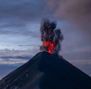
Guatemala , Fuego :
Atmospheric Conditions: Clear
Wind: East
Precipitation: 38.2 mm
Activity
During the night and early morning, weak to moderate degassing was recorded, with fumaroles reaching up to 400 m above the crater and moving mainly westward. Explosive activity continued at a rate of 6 to 10 weak and moderate explosions per hour, generating ash columns between 4,300 and 4,700 meters above sea level, dispersing 10 to 15 km to the west and southwest. This activity produced fine ashfall in Yepocapa and neighboring communities.
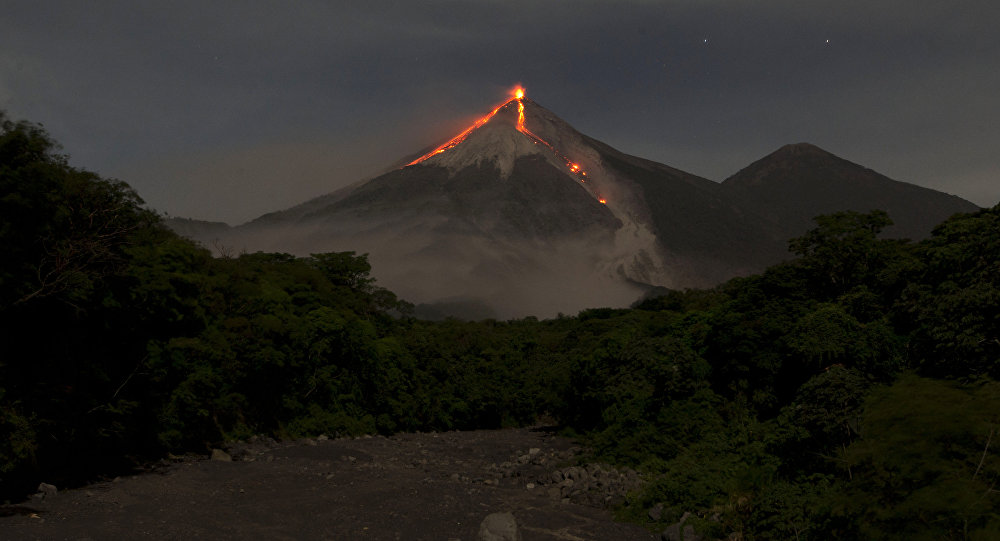
Incandescent material has been observed ejected around the crater, heading towards the Ceniza, Taniluyá, Seca, Santa Teresa, Trinidad, and Las Lajas ravines, sometimes reaching the vegetation line.
Due to the rainy season and the accumulation of debris in the ravines, the risk of lahars persists in the afternoon and evening. It is recommended to avoid the areas around the volcano’s ravines and follow the instructions in special bulletin BEFGO-013-2025.
Source : Insivumeh
Photo : Moises Castillo / Sputnik.