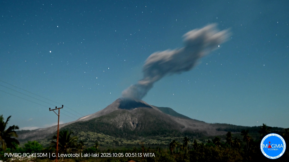
October 5 , 2025.
Indonesia , Lewotobi Laki-laki :
An eruption of Mount Lewotobi Laki-laki occurred on Sunday, October 5, 2025, at 0:57 WITA. The observed ash column was ± 2,500 m above the summit (± 4,084 m above sea level). The ash column was gray and of strong intensity, oriented towards the southwest. This eruption was recorded by seismograph with a maximum amplitude of 14.8 mm and a duration of 196 seconds.
VOLCANO OBSERVATORY NOTICE FOR AVIATION – VONA
Issued : October 5 , 2025 .
Volcano : Lewotobi Laki-laki (264180)
Current Aviation Colour Code : ORANGE
Previous Aviation Colour Code : orange
Source : Lewotobi Laki-laki Volcano Observatory
Notice Number : 2025LWK480
Volcano Location : S 08 deg 32 min 20 sec E 122 deg 46 min 06 sec
Area : East Nusa Tenggara, Indonesia
Summit Elevation : 5069 FT (1584 M)
Volcanic Activity Summary :
Eruption with volcanic ash cloud at 16h57 UTC (00h57 local).
Volcanic Cloud Height :
Best estimate of ash-cloud top is around 13069 FT (4084 M) above sea level or 8000 FT (2500 M) above summit. May be higher than what can be observed clearly. Source of height data: ground observer.
Other Volcanic Cloud Information :
Ash cloud moving to southwest. Volcanic ash is observed to be gray. The intensity of volcanic ash is observed to be thick.
Remarks :
Eruption recorded on seismogram with maximum amplitude 14.8 mm and maximum duration 196 second.
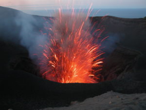
Source et photo : Magma Indonésie .
La Martinique , Mount Pelée :
Weekly report, Paris Institute of Earth Physics, Martinique Volcanological and Seismological Observatory.
Saint-Pierre, October 3, 2025 at 6:00 p.m. local time (GMT-4)
Volcanic activity remained significant this week, with 2,585 earthquakes of volcanic origin observed.
Between September 26, 2025 at 4:00 p.m. (UT) and October 3, 2025 at 4:00 p.m. (UT), the OVSM recorded:
• 2,498 shallow volcano-tectonic earthquakes. Among them, 122 had a magnitude (duration magnitude Md or local magnitude Mlv) greater than 0.5, and 24 had a magnitude greater
than 1. The largest had a magnitude Mlv = 1.95. The others were of lower energy. These earthquakes are located at depths between 0.9 and 4.3 km below the volcano’s summit, as was the case the previous week. A significant number of them originate from one of the well-known seismically active zones on Mount Pelée, located between 1.0 and 1.4 km below the volcano’s summit. The shallow volcano-tectonic seismicity is associated with microfracturing in the volcanic edifice, linked to the global reactivation of the volcano observed since 2019.
• 64 shallow hybrid earthquakes and 21 long-period earthquakes. Among them, 22 have a local magnitude (LMI) greater than 0.5, 5 have a magnitude greater than 1, and 4 have a magnitude greater than 2. The largest has a magnitude LMI = 2.46. The others are of lower energy. These earthquakes are located in the same areas as shallow volcano-tectonic earthquakes. The seismic signals from these types of earthquakes are enriched in (or contain only) low frequencies and are associated with the circulation of fluids (gas, hydrothermal fluids) within the volcanic edifice.
• 1 deep hybrid earthquake with a magnitude of Mlv = 0.8 located at a depth of 23 km west of Mount Pelée; and 1 deep long-period earthquake with a magnitude of Mlv = 0.7 located at a depth of 18 km, also west of Mount Pelée. The seismic signals from these types of earthquakes are enriched in (or contain only) low frequencies and are associated with the circulation of magmatic fluids deep within Mount Pelée’s volcanic system.
No earthquakes have been confirmed as being felt by the public. However, several volcanic earthquakes have a magnitude approaching that of earthquakes likely to be felt by hikers on Mount Pelée.
The previous week, the OVSM recorded 2,267 earthquakes of volcanic origin. As of October 3, 2025, and over the past four weeks, the OVSM has observed a total of 6,101 volcanic earthquakes, an average of 1,525 to 1,526 earthquakes per week.
The seismic energy released by volcanic earthquakes this week remains significant and of the same order of magnitude as during the previous week. This level of energy released by volcanic earthquakes over the past 14 days is the highest recorded since the beginning of reactivation in 2019.
The depth of the hypocenters of the volcano-tectonic earthquakes suggests that mechanical connectivity is beginning to develop between the very superficial parts of the volcano, where seismicity has until now been essentially concentrated, and deeper regions within the edifice, up to approximately 4 km below the volcano’s summit. However, the deformations of the structure are very slight, and do not show to date any marked inflation of the summit zone or evidence of deformations associated with deeper sources. There is currently no evidence of fumarolic activity on Mount Pelée.
During volcanic reactivation phases of volcanoes similar to Mount Pelée, seismic activity of varying intensity and frequency is commonly observed, which can evolve rapidly but also cease rapidly without major changes to the system.
The probability of short-term eruptive activity remains low. However, given all the observations collected since the end of 2018 and their nature, and based on the OVSM-IPGP observations summarized in the latest monthly bulletin (August 2025) and the data recorded over the past 14 days, we cannot rule out a change in the situation in the medium term (months, weeks). Given the uncertainties inherent in anticipating the evolution of volcanic processes, the activity is closely monitored by the OVSM-IPGP, which has strengthened its monitoring resources.
For more details on the observations and interpretations of volcanic activity over the longer term, refer to the OVSM monthly bulletins. The monthly bulletin for September 2025 will be published in the coming days.
The volcanic alert level, in accordance with the authorities’ planned measures, is currently YELLOW: Vigilance.
The alert level is currently YELLOW: Vigilance.
Source : Direction de l’OVSM-IPGP.
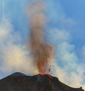
Photos : Photopoesie , Martinique . org .
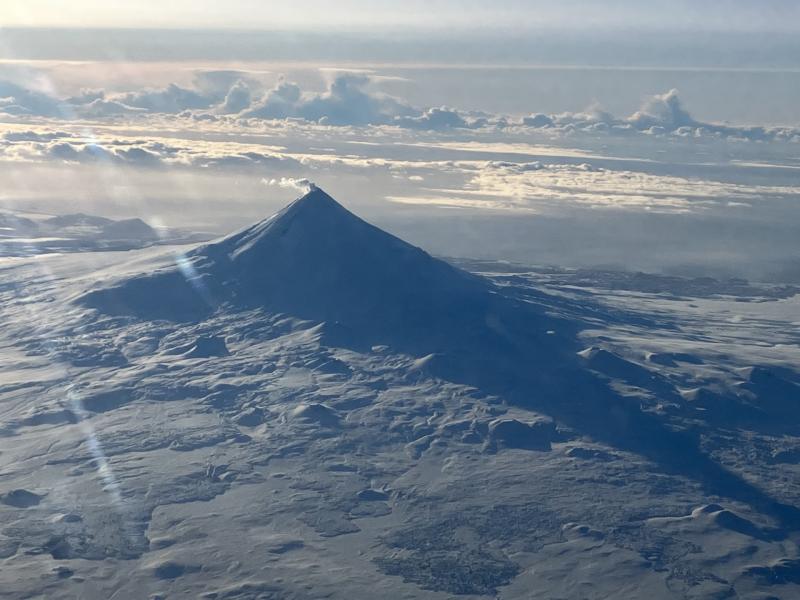
Alaska , Shishaldin :
Frequent small earthquakes and infrasound signals, possibly caused by gas bubbles bursting deep within the crater, were detected over the past day. High clouds yesterday afternoon prevented the satellite-based detection of sulfur dioxide gas emissions that have been prevalent over the past several months. Web camera images were obscured by clouds.
Local seismic and infrasound sensors, web cameras, and a geodetic network are used to monitor Shishaldin Volcano. In addition to the local monitoring network, AVO uses nearby geophysical networks, regional infrasound and lighting data, and satellite images to detect eruptions.
Source : AVO.
Photo : Beesley, Nick
Kamchatka , Sheveluch :
VOLCANO OBSERVATORY NOTICE FOR AVIATION (VONA)
Issued: October 5 ,2025
Volcano: Sheveluch (CAVW #300270)
Current aviation colour code: ORANGE
Previous aviation colour code: orange
Source: KVERT
Notice Number: 2025-109
Volcano Location: N 56 deg 38 min E 161 deg 18 min
Area: Kamchatka, Russia
Summit Elevation: 3283 m (10768.24 ft), the dome elevation ~2500 m (8200 ft)
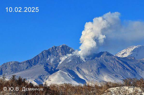
Volcanic Activity Summary:
Satellite data by KVERT shows a strong wind lifts ash from the eastern slopes of Sheveluch volcano, and a plume of resuspended ash is extending about 125 km to the east-south-east of the volcano.
There is NO eruption, but an resuspended ash. Ongoing activity could affect low-flying aircraft.
Volcanic cloud height:
2500-3000 m (8200-9840 ft) AMSL Time and method of ash plume/cloud height determination: 20251004/2350Z – Himawari-9 14m15
Other volcanic cloud information:
Distance of ash plume/cloud of the volcano: 125 km (78 mi)
Direction of drift of ash plume/cloud of the volcano: ESE / azimuth 110 deg
Time and method of ash plume/cloud determination: 20251004/2350Z – Himawari-9 14m15
Source : Kvert
Photo : Yu. Demyanchuk. IVyS Branche extrême-orientale de l’Académie des sciences de Russie, KVERT.
Colombia , Galeras :
San Juan de Pasto, September 30, 2025, 4:10 p.m.
Regarding the monitoring of the activity of the Galeras Volcano, the Colombian Geological Survey (SGC), an entity attached to the Ministry of Mines and Energy, reports that:
During the week of September 23 to 29, 2025, the main variations in the monitored parameters compared to the previous week were:
● A slight decrease in seismic occurrence and energy release was recorded compared to the previous week. Seismicity associated with rock fracturing remains predominant.
● Regarding seismicity, two groups can be distinguished. In the first, the events were located close to the main crater, at distances less than 1.0 km, at depths less than 2.0 km from the summit of Galeras (4,200 m above sea level) and with magnitudes less than 0.4. The second group of earthquakes was located scattered throughout the volcanic edifice within a radius of 20 km, with depths ranging from 4 to 16 km, and a maximum magnitude of 1.7.

● Low gas emissions were observed, mainly from the fumarole fields of El Paisita, to the north, and Las Chavas, to the west of the active cone. The plumes were white in color, with variable dispersion influenced by wind direction and speed.
● Other volcanic monitoring parameters showed stability.
In view of the above, the SGC recommends closely monitoring developments through weekly bulletins and other information published through our official channels, as well as instructions from local and departmental authorities and the National Disaster Risk Management Unit (UNGRD).
Volcanic activity remains on yellow alert: active volcano with changes in the baseline behavior of monitored parameters and other manifestations.
Source et photo : SGC.