September 28 , 2025.
Alaska , Katmai :
ALASKA VOLCANO OBSERVATORY INFORMATION STATEMENT , U.S. Geological Survey
Saturday, September 27, 2025, 7:23 AM AKDT (Saturday, September 27, 2025, 15:23 UTC)
58°16’44 » N 154°57’12 » W,
Summit Elevation 6716 ft (2047 m)
Current Volcano Alert Level: NORMAL
Current Aviation Color Code: GREEN
Strong northwesterly winds in the vicinity of Katmai and the Valley of Ten Thousand Smokes have picked up loose volcanic ash erupted during the 1912 Novarupta-Katmai eruption and are carrying it to the southeast. The National Weather Service has issued a SIGMET for this low-level event and suggests that the maximum cloud height is 6,000 ft (1.8 km) above sea level.
This phenomenon is not the result of recent volcanic activity and occurs during times of high winds and dry snow-free conditions in the Katmai area and other young volcanic areas of Alaska. No eruption is in progress. All of the volcanoes of the Katmai area (Griggs, Katmai, Novarupta, Mageik, Martin, Snowy and Trident) remain at Aviation Color Code GREEN and Alert Level NORMAL. Resuspended volcanic ash should be considered hazardous and could be damaging to aircraft and health.
.
Source : AVO.
Photo : Izbekov, Pavel / AVO/UAF-GI.
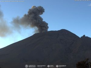
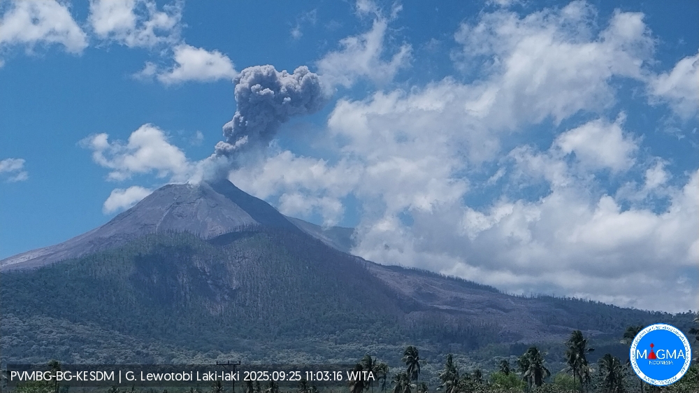
Indonesia , Lewotobi Laki-laki :
An eruption of Mount Lewotobi Laki-laki occurred on Sunday, September 28, 2025, at 9:51 a.m. (local time). The observed ash column was ± 1,200 m above the summit (± 2,784 m above sea level). The ash column was gray and of significant intensity, oriented towards the West and Northwest. This eruption was recorded by seismograph with a maximum amplitude of 22.2 mm and a duration of 79 seconds.
VOLCANO OBSERVATORY NOTICE FOR AVIATION – VONA
Issued : September 28 , 2025
Volcano : Lewotobi Laki-laki (264180)
Current Aviation Colour Code : ORANGE
Previous Aviation Colour Code : orange
Source : Lewotobi Laki-laki Volcano Observatory
Notice Number : 2025LWK460
Volcano Location : S 08 deg 32 min 20 sec E 122 deg 46 min 06 sec
Area : East Nusa Tenggara, Indonesia
Summit Elevation : 5069 FT (1584 M)
Volcanic Activity Summary :
Eruption with volcanic ash cloud at 01h51 UTC (09h51 local).
Volcanic Cloud Height :
Best estimate of ash-cloud top is around 8909 FT (2784 M) above sea level or 3840 FT (1200 M) above summit. May be higher than what can be observed clearly. Source of height data: ground observer.
Other Volcanic Cloud Information :
Ash cloud moving from west to northwest. Volcanic ash is observed to be gray. The intensity of volcanic ash is observed to be thick.
Remarks :
Eruption recorded on seismogram with maximum amplitude 22.2 mm and maximum duration 79 second.
Source et photo : Magma Indonésie .
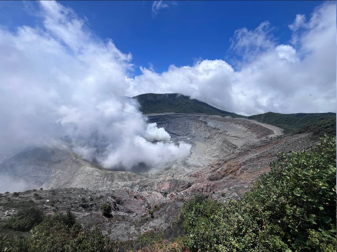
Colombia , Puracé – Los Coconucos volcanic chain:
Popayán, September 23, 2025, 4:30 p.m.
Regarding the monitoring of the activity of the Puracé volcano and the Los Coconucos volcanic chain, the Colombian Geological Survey (SGC), an entity affiliated with the Ministry of Mines and Energy, reports that:
During the week of September 16 to 22, 2025, the seismic record continued to show a persistent signal associated with fluid dynamics in the volcanic conduits,
classified as a continuous low-energy volcanic tremor. Fracture seismicity remained stable in terms of the number of events and energy compared to previous weeks. It was located mainly between the Puracé and Piocollo volcanoes, at depths between 1 and 3 km, with magnitudes less than 1.
The fluid-related earthquakes were mainly located beneath the western flank of the Puracé volcano crater, at a depth of less than 1 km. This seismic activity included tremor pulses associated with increased gas emissions from the crater. An increase in sulfur dioxide (SO2) emissions compared to previous weeks was recorded using satellite detection and field instruments. Furthermore, the slow deformation process detected after the eruption of the Curiquinga volcano on January 20, 2025, continues.
Images captured by satellite sensors and visible and infrared webcams have observed degassing processes and thermal anomalies inside the crater of Puracé Volcano and in the fumarole field on its outer rim.
In conclusion, the variations observed at Puracé Volcano (Los Coconucos volcanic chain) indicate that the system remains active and that monitoring parameters remain above their reference values. Under yellow alert status, phenomena such as sporadic ash emissions (minor eruptions of limited magnitude and impact, whose dispersion depends on wind direction), the presence of incandescence, small explosions in the crater, low-energy thermal anomalies, noise, felt earthquakes, odors, precipitation of elemental sulfur near the crater, in hot springs and fumaroles, as well as degassing outside the crater, may occur. Fissure formation and minor lahar formation, among other things, may also occur.
The alert status for volcanic activity remains yellow: an active volcano exhibiting changes in the baseline behavior of monitored parameters and other manifestations.
Source : SGC.
Photo : Cric-colombia .org
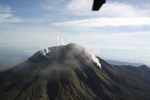
Ecuador , Sangay :
DAILY STATUS REPORT OF SANGAY VOLCANO, Saturday, September 27, 2025.
Information Geophysical Institute – EPN.
Surface Activity Level: Moderate, Surface Trend: No Change
Internal Activity Level: Moderate, Internal Trend: No Change
Seismicity: From September 26, 2025, 11:00 a.m. to September 27, 2025, 11:00 a.m.:
Seismicity:
Below is the count of seismic events recorded at the reference station.
Explosion (EXP): 83
Rainfall/Lahars:
No rainfall has been recorded in the volcanic area. **Heavy rainfall could remobilize accumulated material, generating mud and debris flows that would cascade down the volcano’s flanks and flow into adjacent rivers**.
Emissions/Ash Column:
Monitoring cameras have observed several gas and ash emissions at altitudes between 700 and 1,000 meters above the crater, in a west and northwest direction. In this regard, the Washington VAAC agency published a report of gas and ash emissions at an altitude of 850 meters above the crater, in a north-northwest direction.
Gas:
The MOUNTS satellite system reported 3.60 tons of sulfur dioxide (SO₂) today, measured yesterday at 2:04 p.m. (local time).
Observation:
Early in the morning, surveillance cameras recorded the descent of incandescent material 1,200 meters below the crater level, along the northwest flank. At the time of writing, the volcano remains cloudy.
Alert Level: Yellow
Source : IGEPN
Photo : Cristopher Cardenas / FB.
Costa Rica , Poas :
OVSICORI-UNA Weekly Volcano Monitoring Bulletin, September 26, 2025
Latitude: 10.20°N;
Longitude: 84.23°W;
Altitude: 2,687 m.
Current Activity Level: Alert
No eruptions have been recorded since Tuesday, September 9.
The amplitude of the background seismic tremor remains stable compared to recent months.
Almost no acoustic tremor has been recorded. This week, a distal volcano-tectonic event was located on the northern flank of the von Frantzius cone. The number of long-period events has been increasing since last week.
The geodetic network is currently not recording any significant deformation. MultiGAS stations measured an average SO₂/CO₂ ratio of 1.7 ± 0.4 this week, slightly higher than last week’s (1.5 ± 0.7). The H₂S/SO₂ ratio has remained very low (< 0.1) in recent weeks. The ExpoGAS station, located on the visitor observation deck, measured a maximum of 3.9 ppm SO₂ this week. DOAS stations measured an SO₂ flux of 272 ± 102 t/d, similar to the previous week (243 ± 175 t/d). Furthermore, satellite measurements of atmospheric SO₂ remained detectable, with a maximum value of 318.8 tonnes on September 19, down from the previous week.
This week, the lake’s level continued to drop. If this trend continues, it could soon split into two lakes. The lake has been measured at over 70°C, and the sulfur-rich fumaroles at over 210°C.
Source : Ovsicori.
Photo : RSN-UCR ( archive)