August 09 , 2025.
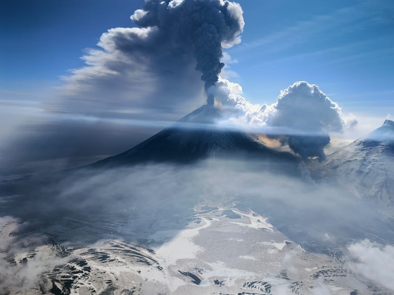
Kamchatka , Klyuchevskoy :
VOLCANO OBSERVATORY NOTICE FOR AVIATION (VONA)
Issued: August 08 , 2025
Volcano: Klyuchevskoy (CAVW #300260)
Current aviation colour code: RED
Previous aviation colour code: red
Source: KVERT
Notice Number: 2025-57
Volcano Location: N 56 deg 3 min E 160 deg 38 min
Area: Kamchatka, Russia
Summit Elevation: 4750 m (15580 ft)
Volcanic Activity Summary:
A summit explosive-effusive eruption of the volcano continues. Satellite data by KVERT showed explosions sent ash up to 9-10 km a.s.l., and ash plume is extending for 1800 km to the south-east of the volcano. A move of lava flows and ash emission from summit crater of the volcano continues.
A summit explosive-effusive eruption of the volcano continues. Ash explosions up to 15 km (49,200 ft) a.s.l. could occur at any time. Ongoing activity could affect international and low-flying aircraft.
Volcanic cloud height:
9000-10000 m (29520-32800 ft) AMSL Time and method of ash plume/cloud height determination: 20250808/0830Z – Himawari-9 14m15
Other volcanic cloud information:
Distance of ash plume/cloud of the volcano: 1800 km (1119 mi)
Direction of drift of ash plume/cloud of the volcano: ESE / azimuth 119 deg
Time and method of ash plume/cloud determination: 20250808/0830Z – Himawari-9 14m15
Source : Kvert
Photo : Vulcanyia
Colombia , Nevado del Ruiz :
Manizales, August 5, 2025, 7:00 p.m.
Regarding the monitoring of the activity of the Nevado del Ruiz volcano, the Colombian Geological Survey (SGC), an entity attached to the Ministry of Mines and Energy, reports that:
During the week of July 29 to August 4, 2025, the volcano continued to exhibit unstable behavior. Compared to the previous week, the main variations in the monitored parameters were:
– Seismicity related to fluid dynamics in the volcanic conduits decreased, with a similar number of recorded earthquakes and released seismic energy levels. The energy levels of the seismic signals were mostly low, sometimes moderate. Thanks to the cameras used for visual monitoring of the volcano (conventional or thermographic), as well as reports from SGC field personnel and officials of the Los Nevados National Natural Park (P.N.N.N.), several pulsed ash emissions and variations in the apparent temperature of the emitted materials were confirmed, associated with this seismic activity.
– Seismic activity associated with rock fracturing processes within the volcanic edifice decreased the number of recorded earthquakes and maintained similar levels of released seismic energy. The earthquakes were located mainly in the Arenas Crater and in the northwest sector, at distances of up to 10 km from the Arenas Crater. To a lesser extent, seismic activity was recorded on the northeast, east, southwest, and southeast flanks, within a radius of 5 km around the crater. The depth of the earthquakes ranged from less than 1 km to 9 km from the volcanic summit. The earthquake, which occurred at 5:07 a.m. on August 2, with a magnitude of 1.3, was the largest of the week. It was located 10 km northwest of the crater, at a depth of 6 km.
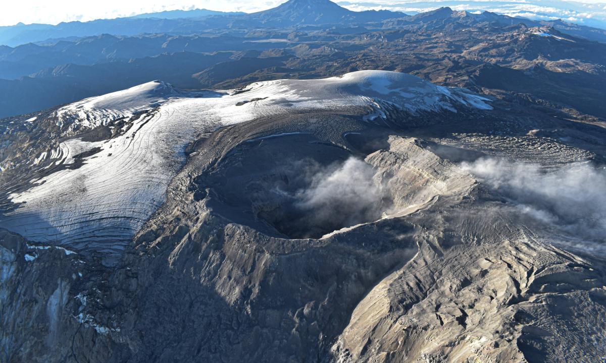
– Water vapor and gas emissions, primarily sulfur dioxide (SO₂), into the atmosphere through the Arenas crater varied throughout the week. Estimated SO₂ flux values associated with degassing were similar to those recorded the previous week.
– The vertical height of the gas, water vapor, and ash column remained below the 500 m measured above the volcano’s summit. During dispersal, the height was greater than 1,800 m; this value was estimated during the ash emission recorded on July 31 at 3:11 p.m.
Regarding the direction of dispersal, the column showed a preferential trend toward the northwest and east-northeast flanks of the volcano. According to these wind directions, on July 29 and 31, ashfall was reported in the Valle de las Tumbas (Valley of the Tombs) sector, in the NNNN National Park, and in Nereidas (Nereidas), in the municipality of Villamaría (Caldas department), respectively.
– When monitoring thermal anomalies at the floor of the Arenas crater using satellite monitoring platforms, detection was limited by the persistence of atmospheric conditions of high cloud cover in the volcanic area. However, some low-energy anomalies were reported.
Source et photo : SGC
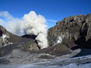
Japan , Sakurajima :
The Japan Meteorological Agency (JMA) reported ongoing eruptive activity at Minamidake Crater (Aira Caldera’s Sakurajima volcano) during 28 July-4 August. Three explosions occurred at the Minamidake crater 28-30 July, with ash plumes rising up to 1 km (3,300 ft) above the crater rim. On 2 August at 2006, an explosion produced an ash plume that rose 1.1 km (3,600 ft) above the rim. Very small eruptive events occasionally occurred during 3-4 August. The Alert Level remained at 3 (on a 5-level scale), and the public was warned to be cautious within 2 km of both the Minimadake and Showa craters.
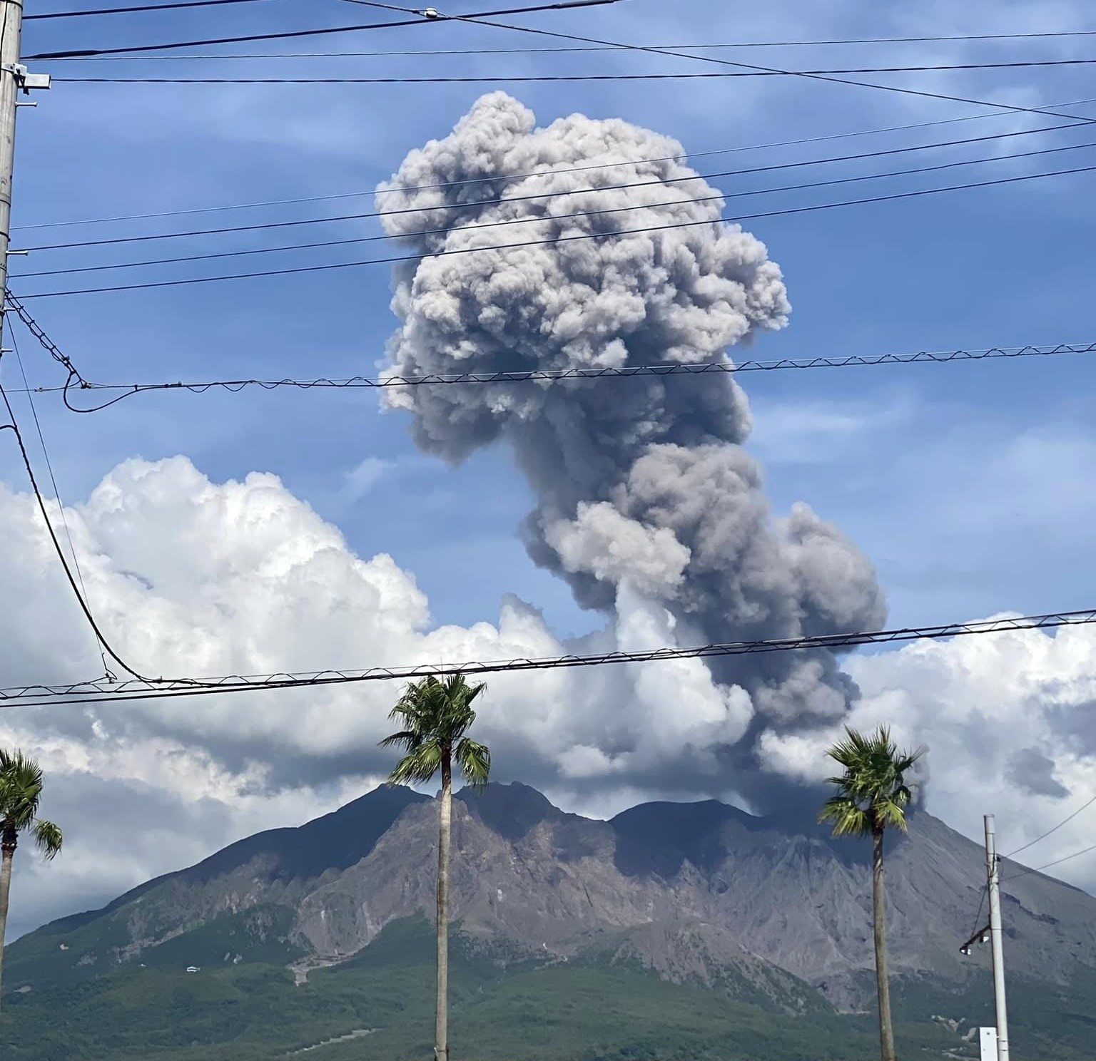
The Aira caldera in the northern half of Kagoshima Bay contains the post-caldera Sakurajima volcano, one of Japan’s most active. Eruption of the voluminous Ito pyroclastic flow accompanied formation of the 17 x 23 km caldera about 22,000 years ago. The smaller Wakamiko caldera was formed during the early Holocene in the NE corner of the caldera, along with several post-caldera cones. The construction of Sakurajima began about 13,000 years ago on the southern rim and built an island that was joined to the Osumi Peninsula during the major explosive and effusive eruption of 1914. Activity at the Kitadake summit cone ended about 4,850 years ago, after which eruptions took place at Minamidake. Frequent eruptions since the 8th century have deposited ash on the city of Kagoshima, located across Kagoshima Bay only 8 km from the summit. The largest recorded eruption took place during 1471-76.
Sources : Agence météorologique japonaise (JMA), GVP.
Photo : Kumiko Nagai
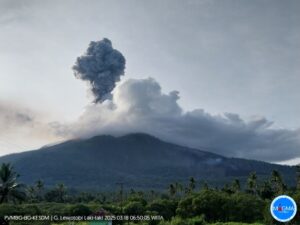
Indonesia , Lewotobi Laki-laki :
An eruption of Mount Lewotobi Laki-laki occurred on Saturday, August 9, 2025, at 02:39 WITA. The observed ash column was ± 1,200 m above the summit (± 2,784 m above sea level). The ash column was gray and of strong intensity, oriented towards the West and Northwest. This eruption was recorded by seismograph with a maximum amplitude of 9.6 mm and a duration of 64 seconds.
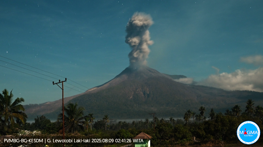
VOLCANO OBSERVATORY NOTICE FOR AVIATION – VONA
Issued : August 09 , 2025
Volcano : Lewotobi Laki-laki (264180)
Current Aviation Colour Code : ORANGE
Previous Aviation Colour Code : orange
Source : Lewotobi Laki-laki Volcano Observatory
Notice Number : 2025LWK363
Volcano Location : S 08 deg 32 min 20 sec E 122 deg 46 min 06 sec
Area : East Nusa Tenggara, Indonesia
Summit Elevation : 5069 FT (1584 M)
Volcanic Activity Summary :
Eruption with volcanic ash cloud at 18h39 UTC (02h39 local).
Volcanic Cloud Height :
Best estimate of ash-cloud top is around 8909 FT (2784 M) above sea level or 3840 FT (1200 M) above summit. May be higher than what can be observed clearly. Source of height data: ground observer.
Other Volcanic Cloud Information :
Ash cloud moving from west to northwest. Volcanic ash is observed to be gray. The intensity of volcanic ash is observed to be thick.
Remarks :
Eruption recorded on seismogram with maximum amplitude 9.6 mm and maximum duration 64 second.
Source et photo : Magma Indonésie .
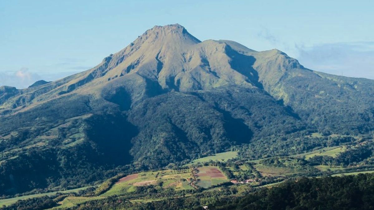
La Martinique , Mount Pelée :
Weekly Report, Paris Institute of Earth Physics, Martinique Volcanological and Seismological Observatory
Saint-Pierre, August 8, 2025 at 4:00 PM (GMT-4)
Volcanic activity was characterized this week by 168 observed earthquakes of volcanic origin.
Between August 1, 2025 at 4:00 PM (UTC) and August 8, 2025 at 4:00 PM (UTC), the OVSM recorded:
• 166 low-energy volcano-tectonic earthquakes. These earthquakes were clearly identified as originating from one of the well-known seismically active zones on Mount Pelée,
located between 1.0 and 1.4 km deep below the volcano’s summit. The shallow volcano-tectonic seismicity is associated with microfracturing in the volcanic edifice, linked to the global reactivation of the volcano observed since late 2018.
• Two shallow hybrid earthquakes, with magnitudes Md 1.05 and 1.1, located approximately 1 km deep beneath the domes of Mount Pelée. The hybrid seismic signals are enriched in low frequencies and are associated with the presence of fluids (gas, hydrothermal fluids) in the volcanic edifice.
No earthquakes were felt by the population.
The previous week, the OVSM recorded 275 earthquakes of volcanic origin. As of August 8, 2025, and over the past four weeks, the OVSM has observed a total of 593 volcanic earthquakes, an average of 148 to 149 earthquakes per week.
During phases of volcanic reactivation in volcanoes similar to Mount Pelée, seismic activity of varying intensity and frequency is commonly observed.
For more details on observations and interpretations of volcanic activity over the longer term, refer to the OVSM’s monthly bulletins.
The alert level is currently YELLOW: vigilance.
Source et photo : Direction de l’OVSM-IPGP.