June 30 , 2025 .
Hawaii , Kilauea :
HVO/USGS Volcanic Activity Notice
Current Volcano Alert Level: WATCH
Current Aviation Color Code: ORANGE
Issued: Sunday, June 29, 2025, 9:31 AM HST
Source: Hawaiian Volcano Observatory
Notice Number: 2025/H301
Location: N 19 deg 25 min W 155 deg 17 min
Elevation: 4091 ft (1247 m)
Area: Hawaii
Volcanic Activity Summary:
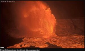
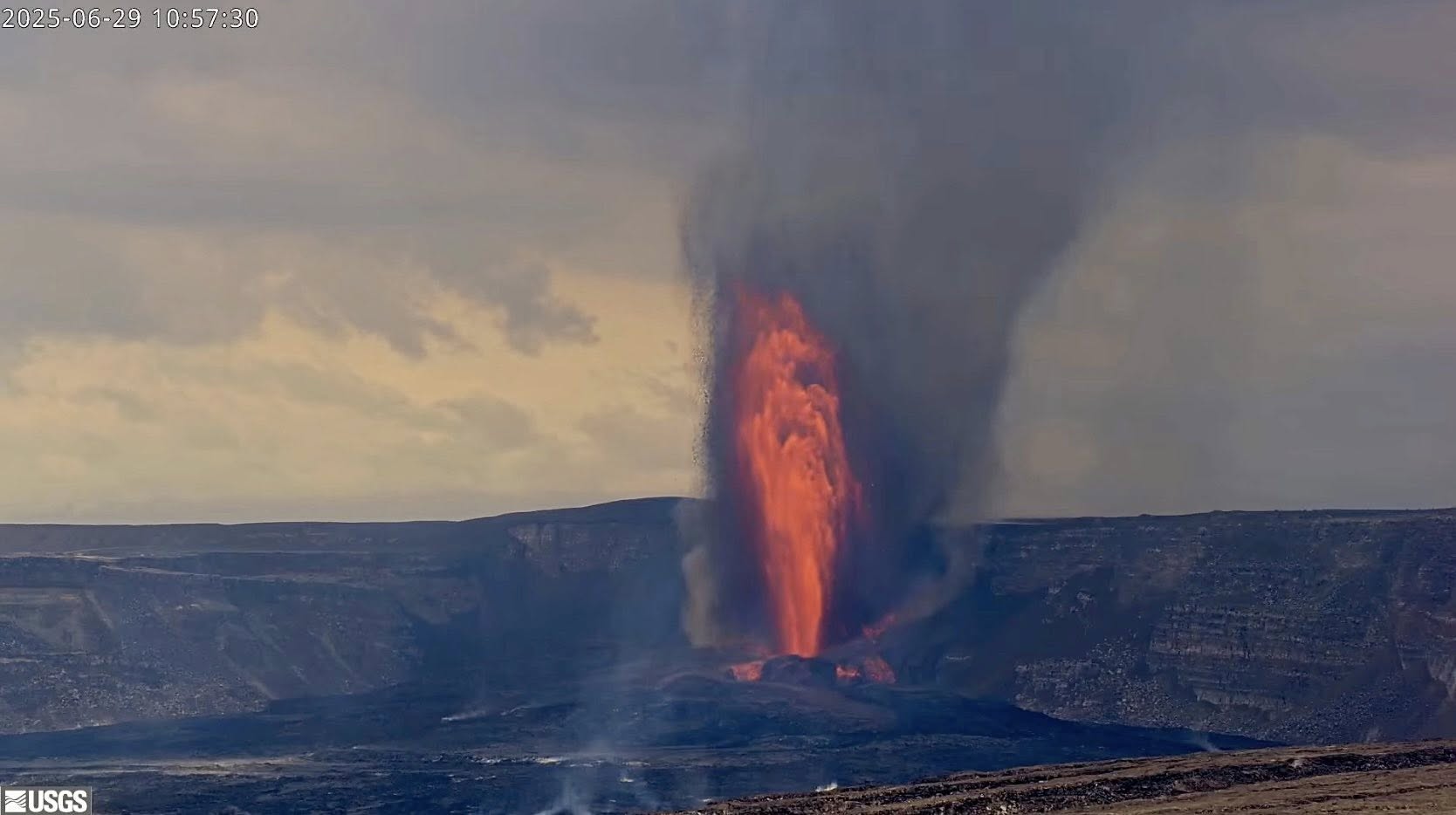
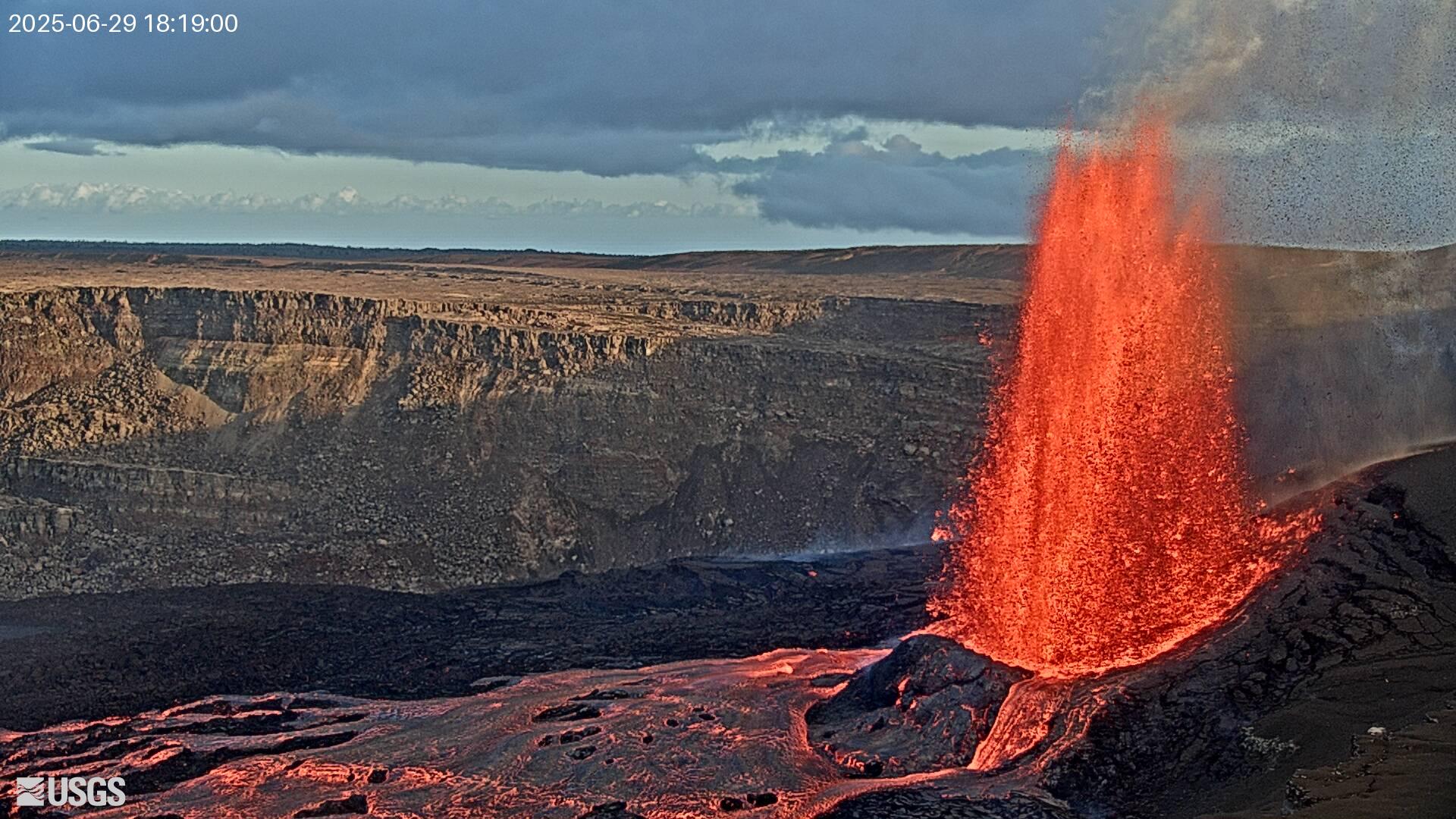
Episode 27 of the ongoing Halemaʻumaʻu eruption began at 9:05 a.m. HST on June 29, 2025, when ongoing lava fountains from the north vent became more vigorous. These fountains are now reaching heights of about 500 feet (150 meters) and feeding multiple lava streams that are flowing onto the crater floor. Fountain heights can be expected to increase further in the next hour or so.
According to the National Weather Service, winds are blowing from the northeast to east direction, though field observations indicate that actual wind conditions are more variable. Consequently, at this time it is uncertain what direction volcanic gas emissions and tephra from the lava fountain may be distributed around Halemaʻumaʻu.
Episode 27 was preceded by small, sporadic dome fountains in the north vent that began at approximately 7:27 a.m. HST. These fountains continued to increase in vigor over the next hour and a half, before becoming taller at 9:05 a.m. HST.
Inflationary tilt reached just over 16.5 microradians since the end of episode 26, after recording 18.5 microradians of deflationary tilt during that episode. Seismic tremor began increasing and tilt at station UWD switched from inflationary to deflationary at about 7:30 a.m. HST, around the same time lava flows began erupting onto the crater floor.
Most episodes of Halemaʻumaʻu lava fountaining since December 23, 2024, have continued for around a day or less and have been separated by pauses in eruptive activity lasting generally at least several days.
No changes have been detected in the East Rift Zone or Southwest Rift Zone. A VAN/VONA will be issued when sustained lava fountaining ceases and the eruption is paused, or earlier if the situation warrants a further update.
Kīlauea Volcano Alert Level/Aviation Color Code remain at WATCH/ORANGE. All current and recent activity is within Hawaiʻi Volcanoes National Park.
Source : HVO.
Photos : USGS.
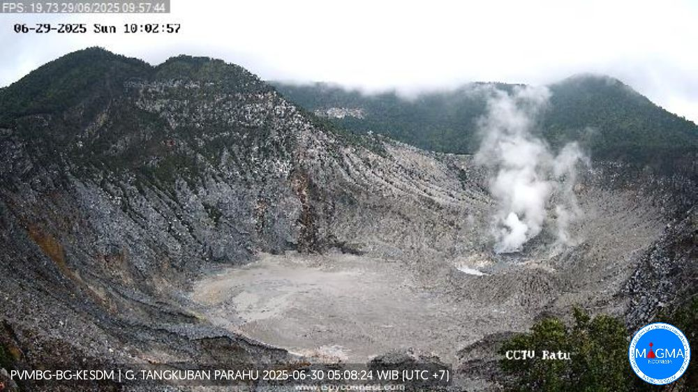
Indonesia , Tangkuban Parahu :
SPECIAL REPORT ON THE ACTIVITY OF TANGKUBAN PARAHU VOLCANO, WEST JAVA, JUNE 29, 2025
Tangkuban Parahu is an active volcano located in West Java Province. It has nine craters, including two main summit craters, Kawah Ratu and Kawah Upas.
On June 29, 2025, at 8:49:42 a.m. (West Java Time), an earthquake occurred. According to BMKG data, it measured 2.7 on the Richter scale, located at 6.76 LS – 107.63 BT and at a depth of 6 km below sea level. This earthquake was felt from the Tangkuban Parahu PGA station on the III/MMI scale.
Following the earthquake, volcanic activity at Mount Tangkuban Parahu did not increase visually. Low to moderate white smoke was observed at a height of between 20 and 200 meters from the floor of Ratu Crater and between 5 and 10 meters from the floor of Ecoma Crater, with low to moderate pressure. The mud bubble formed in Ratu Crater on June 5, 2025, is still observed, with its intensity and surface area remaining unchanged.
Seismic monitoring has not shown any increase to date; seismic recordings remain dominated by « continuous tremor » vibrations associated with mud bubble activity in Ratu Crater. Seismic recordings from June 28, 2025, recorded three emission earthquakes, 84 low-frequency (LF) earthquakes, one distant tectonic earthquake (TJ), and continuous tremor vibrations with an amplitude of 0.5 to 1.5 mm.
The seismic activity from June 29, 2029, until 12:00 WIB, recorded 41 low-frequency (LF) earthquakes, two deep volcanic earthquakes (DVE), one emission earthquake, one distant tectonic earthquake (DTE), and one felt earthquake (scale III/MMI continuous vibration) with an amplitude of 0.5 to 1 mm.
Observations of surface deformation by EDM, GNSS, and tiltmeter after the felt earthquake had no significant effect on pressure variation beneath the volcano’s body. However, EDM monitoring data still show an inflationary trend, indicating pressure buildup at shallow depths beneath the volcano’s body. This phenomenon must be taken into account, as the risk of phreatic eruptions can occur suddenly, without being preceded by obvious volcanic symptoms.
As of June 29, 2025, gas measurements from the permanent Multi-GAS station revealed no significant changes in the gas/CO₂, CO₂/H₂S, H₂O/CO₂, H₂S/SO₂ ratios, or the SO₂ to H₂S ratio.
Given all of the above data, the activity level of Mount Tangkuban Parahu remains at Level I (normal). Residents and visitors near Mount Tangkuban Parahu are still advised not to approach the crater base, not to linger there, and to move away immediately in the event of an increase in the intensity of emissions or a strong smell of gas. Although activity has decreased, vigilance remains required. The regional government and the BPBD are requested to continue their coordination with the Tangkuban Parahu Volcano Observation Post, located in Cikole Village, and the Bandung Volcanology and Geological Disaster Mitigation Center.
Source et photo : PVMBG.
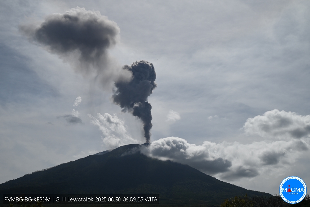
Indonesia , Ili Lewotolok :
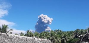
An eruption of Mount Ili Lewotolok occurred on Monday, June 30, 2025, at 9:59 WITA. The observed ash column was ± 1,200 m above the summit (± 2,623 m above sea level). The ash column was gray to black in color, with a strong intensity, oriented southwest. This eruption was recorded by seismograph with a maximum amplitude of 12.1 mm and a duration of 52 seconds.
VOLCANO OBSERVATORY NOTICE FOR AVIATION – VONA
Issued : june 30 , 2025
Volcano : Ili Lewotolok (264230)
Current Aviation Colour Code : ORANGE
Previous Aviation Colour Code : orange
Source : Ili Lewotolok Volcano Observatory
Notice Number : 2025LEW039
Volcano Location : S 08 deg 16 min 19 sec E 123 deg 30 min 18 sec
Area : East Nusa Tenggara, Indonesia
Summit Elevation : 4554 FT (1423 M)
Volcanic Activity Summary :
Eruption with volcanic ash cloud at 01h59 UTC (09h59 local).
Volcanic Cloud Height :
Best estimate of ash-cloud top is around 8394 FT (2623 M) above sea level or 3840 FT (1200 M) above summit. May be higher than what can be observed clearly. Source of height data: ground observer.
Other Volcanic Cloud Information :
Ash cloud moving to southwest. Volcanic ash is observed to be gray to dark. The intensity of volcanic ash is observed to be thick.
Remarks :
Eruption recorded on seismogram with maximum amplitude 12.1 mm and maximum duration 52 second.
Source et photo : Magma Indonésie .
Colombia , Galeras :
San Juan de Pasto, June 24, 2025, 4:40 p.m.
Regarding the monitoring of the activity of the Galeras Volcano, the Colombian Geological Survey (SGC), an entity attached to the Ministry of Mines and Energy, reports that:
During the week of June 17 to 23, 2025, the main variations in the monitored parameters compared to the previous week were:
● A decrease in the occurrence and released seismic energy was recorded, with a predominance of seismicity associated with rock fracturing processes in the volcanic region.
● The earthquakes were located in a dispersed manner, at distances between 0.5 and 17 km, at a depth between 1 and 15 km from the summit (4,200 m above sea level), and with a maximum magnitude of 1.7.
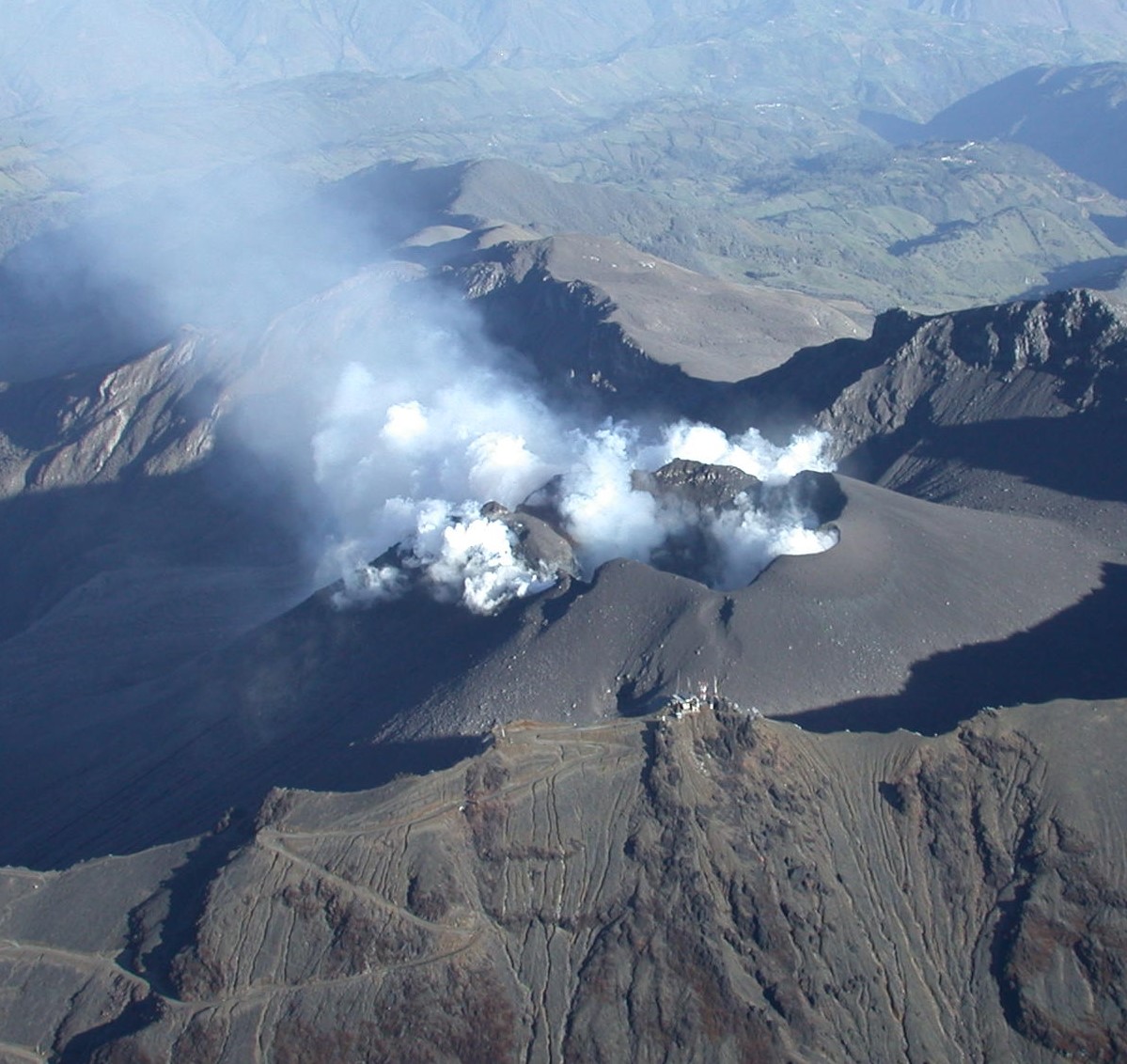
Atmospheric conditions were unfavorable for most of the week, but low-altitude columns of white gas, with variable dispersion depending on the wind, were observed emanating from the fumarole fields of El Paisita, to the north, and Las Chavas, to the west of the active cone. Other volcanic monitoring parameters remained stable.
In view of the above, the SGC recommends closely monitoring developments through weekly bulletins and other information published through our official channels, as well as instructions from local and departmental authorities and the National Disaster Risk Management Unit (UNGRD).
Volcanic activity remains on yellow alert: active volcano with changes in the baseline behavior of monitored parameters and other manifestations.
Source et photo : SGC
Ecuador , Sangay :
SANGAY VOLCANO DAILY STATUS REPORT, Sunday, June 29, 2025.
Information Geophysical Institute – EPN.
Surface Activity Level: High, Surface Trend: No Change
Internal Activity Level: Moderate, Internal Trend: No Change
Seismicity: From June 28, 2025, 11:00 a.m. to June 29, 2025, 11:00 a.m.:
Seismicity:
Below is the count of seismic events recorded at the reference station.
Explosion (EXP): 108
Precipitation/Lahars:
Since yesterday afternoon, no rain has been recorded in the volcano area. **Heavy rains could remobilize the accumulated material, generating mud and debris flows that would cascade down the sides of the volcano and drain into adjacent rivers**.
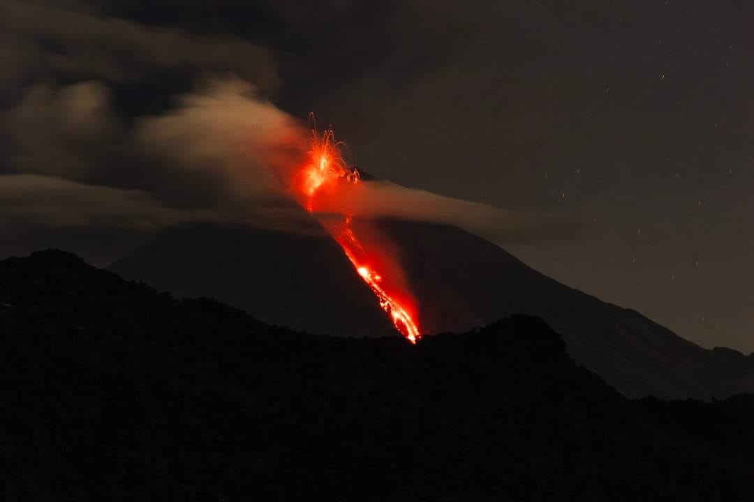
Ash Emission/Column:
Yesterday afternoon, surveillance cameras recorded gas and ash emission reaching 800 meters above the crater level in a southwest direction. In addition, the Washington VAAC agency reported ash clouds reaching approximately 1,800 meters in altitude in a west-northwest direction.
Other Monitoring Parameters:
The FIRMS satellite system recorded four thermal anomalies, the MIROVA-MODIS satellite system two thermal anomalies, and the MIROVA-VIIRS satellite system four thermal anomalies over the past 24 hours.
Observation:
From yesterday afternoon until the closing of this report, the volcano remained mostly cloudy.
Alert Level: Yellow
Source : IGEPN
Photo : Luis Lema via volcan Sangay FB , 30/03/2024