June 23 , 2025 .
Indonesia , Ili Lewotolok / Dukono :
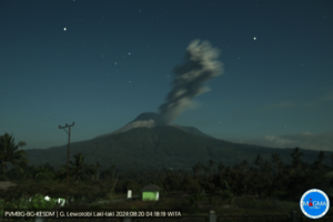
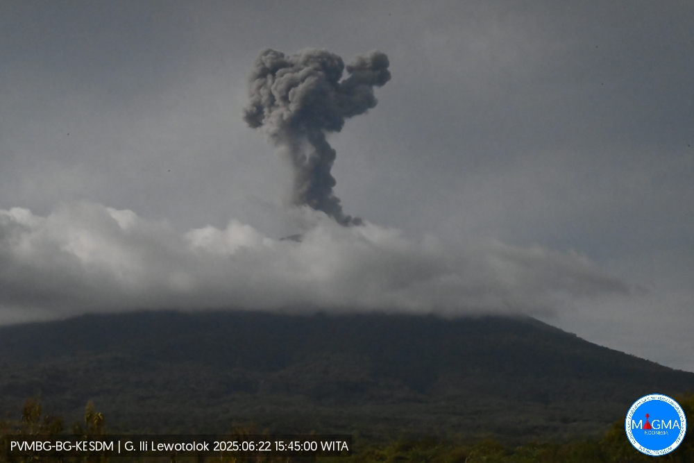
Ili Lewotolok
An eruption of Mount Ili Lewotolok occurred on Sunday, June 22, 2025, at 3:45 p.m. (local time). The observed ash column was approximately 800 m (2,600 ft) above the summit (approximately 2,223 m (7,223 ft) above sea level). The ash column was gray and intense, oriented toward the southwest and west. At the time of this report, the eruption was still ongoing.
VOLCANO OBSERVATORY NOTICE FOR AVIATION – VONA
Issued : June 22 , 2025
Volcano : Ili Lewotolok (264230)
Current Aviation Colour Code : ORANGE
Previous Aviation Colour Code : orange
Source : Ili Lewotolok Volcano Observatory
Notice Number : 2025LEW032
Volcano Location : S 08 deg 16 min 19 sec E 123 deg 30 min 18 sec
Area : East Nusa Tenggara, Indonesia
Summit Elevation : 4554 FT (1423 M)
Volcanic Activity Summary :
Eruption with volcanic ash cloud at 07h45 UTC (15h45 local).
Volcanic Cloud Height :
Best estimate of ash-cloud top is around 7114 FT (2223 M) above sea level or 2560 FT (800 M) above summit. May be higher than what can be observed clearly. Source of height data: ground observer.
Other Volcanic Cloud Information :
Ash cloud moving from southwest to west. Volcanic ash is observed to be gray. The intensity of volcanic ash is observed to be thick.
Remarks :
Eruption recorded on seismogram with maximum amplitude 40 mm and maximum duration 92 second.
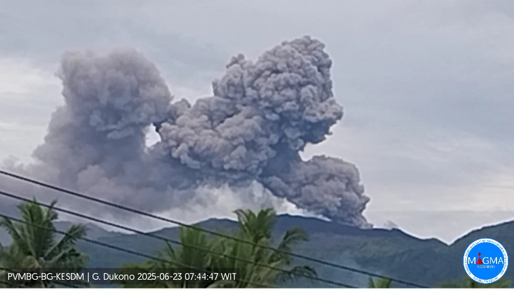
Dukono
An eruption of Mount Dukono occurred on Monday, June 23, 2025, at 7:28 a.m. (local time). The observed ash column was ± 1,200 m above the summit (± 2,287 m above sea level). The ash column was white to gray, with greater intensity toward the east. At the time of this report, the eruption was still ongoing.
Seismicity Observation:
240 eruption earthquakes with an amplitude of 6 to 34 mm and a duration of 31.07 to 130.17 seconds.
1 continuous tremor signal with an amplitude of 2 to 5 mm, with a dominant value of 3 mm.
Recommendation
Residents and visitors/tourists are advised not to engage in any activities, climb, or approach the Malupang Warirang crater within a 4 km radius.
Given that volcanic eruptions are periodic and the distribution of ash follows wind direction and speed, and the ash zone is not fixed, residents are recommended to always wear masks/nose and mouth coverings when needed to avoid any risk of volcanic ash being projected onto the respiratory tract.
Source et photos: Magma Indonésie .
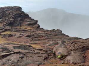
Chile , Puyehue / Cordon Caulle :
Seismology
Seismological activity during this period was characterized by the following:
217 VT-type earthquakes, associated with rock fracturing (volcano-tectonics). The most energetic earthquake, with a local magnitude (LM) of 1.4, was located 1.1 km northeast of the volcanic edifice, at a depth of 4.2 km from the 2011 emission center.
Three LP-type earthquakes, associated with fluid dynamics within the volcanic system (long period). The magnitude of the largest earthquake, estimated using the reduced displacement (RD) parameter, was 17 cm².
Fluid Geochemistry
No anomalies in sulfur dioxide (SO₂) emissions into the atmosphere have been reported near the volcanic complex, according to data published by the Tropospheric Monitoring Instrument (TROPOMI) and the Sulfur Dioxide Monitoring Group of the Ozone Monitoring Instrument (OMI).
Geodesy
According to data obtained from GNSS stations deployed on the volcanic complex, the uplift process of the center of the Cordón Caulle graben continues. The maximum horizontal and vertical displacement rates recorded over the last 30 days are 0.9 cm/month, which maintains a slight decrease in uplift rates compared to the annual average. Furthermore, GNSS stations installed in February 2025, less than 1 km from the 2011 eruption emission center, recorded localized deflation in the area, with a subsidence rate of -3.0 cm/month, considered high and representative of a local process.
According to Sentinel 1A radar images up to June 3 and radar interferometry, the graben inflation process is continuing, with no change in the uplift pattern.
Satellite Thermal Anomalies
During this period, low-power thermal anomalies were recorded in the area where the laccolith is located, northeast of the 2011 emission center. These anomalies recorded a maximum volcanic radiative power (VRP) of 1.4 MW on June 10, according to data processed by the VIIRS sensor of the Mid-Infrared Volcanic Activity Observation Platform (MIROVA).
Surveillance Cameras
Images provided by fixed cameras installed near the volcanic complex did not record any degassing plumes or changes related to surface activity.
Satellite Geomorphological Analysis
Based on observations of Planet Scope Scene and Sentinel 2-L2A satellite images, no morphological changes related to volcanic activity were identified.
During this period, the deformation process localized within the graben continued with an inflationary trend and a stable rate over time, with no signs of significant increase or decrease.
This phenomenon was accompanied by low-energy surface seismic activity with slight variations.
Therefore, it is determined that the volcanic system remains in its initial state, maintaining its technical alert level:
YELLOW TECHNICAL ALERT: Changes in the behavior of volcanic activity.
Source : Sernageomin
Photo : mmq- photography.com
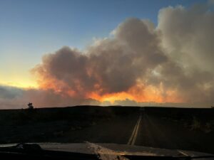
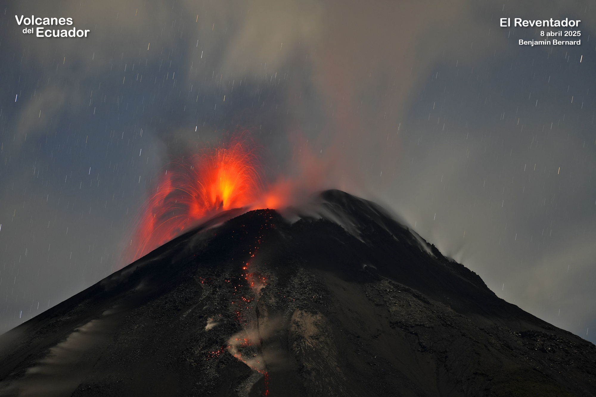
Ecuador , El Reventador :
DAILY STATUS REPORT OF REVENTADOR VOLCANO, Sunday, June 22, 2025.
Information Geophysical Institute – EPN.
Surface Activity Level: High, Surface Trend: No change
Internal Activity Level: Moderate, Internal Trend: No change
From June 21, 2025, 11:00 a.m. to June 22, 2025, 11:00 a.m.:
Seismicity:
Below is the count of seismic events recorded at the reference station.
Explosion (EXP) 87
Long Period (LP) 6
Emission Tremor (TREMI) 7
Harmonic Tremor (TRARM) 5
Precipitation/Lahars:
No rainfall has been recorded in the volcanic area. **Heavy rainfall could remobilize accumulated material, generating mud and debris flows that would cascade down the volcano’s flanks and flow into adjacent rivers.**
Emission/Ash Plume:
Since yesterday afternoon, several plumes of gas and ash, ranging from 500 to 1,000 meters above the crater, have been recorded by the surveillance camera network in the west, northeast, northwest, and west-northwest directions. These emissions were also observed by the GOES-19 satellite system in the west-northwest direction. Regarding this activity, the Washington VAAC has issued four reports of ash clouds in the west and northwest directions, reaching a height of 700 meters above the crater.
Other monitoring parameters:
The MIROVA-MODIS satellite system recorded one thermal anomaly, the MIROVA-VIIRS system four thermal anomalies, and the FIRMS satellite system two thermal anomalies over the past 24 hours.
Observation:
During the night and early morning, surveillance cameras observed several episodes of incandescent material falling on the volcano’s flanks, up to 1,000 meters below the crater level. At the time of writing, the volcano remains clear.
Alert Level – SGR: Orange
Source : IGEPN
Photo : Benjamin Bernard , Volcanes del equateur , 2/11/2024
Vanuatu Archipelago , Ambae :
The volcanic activity on Ambae continues in the major unrest state. The Ambae Volcanic Alert Level remains at Level 2.
Major volcanic unrest at Ambae continues and remains confined to Lake Voui. Latest field observations and data analysis have confirmed that the Ambae volcanic activity shows ongoing unrest and suggest that its activity is likely to continue at a similar level, consistent with volcanic alert level 2. The volcanic hazards danger zone remains limited at 2 km radius from active vents.
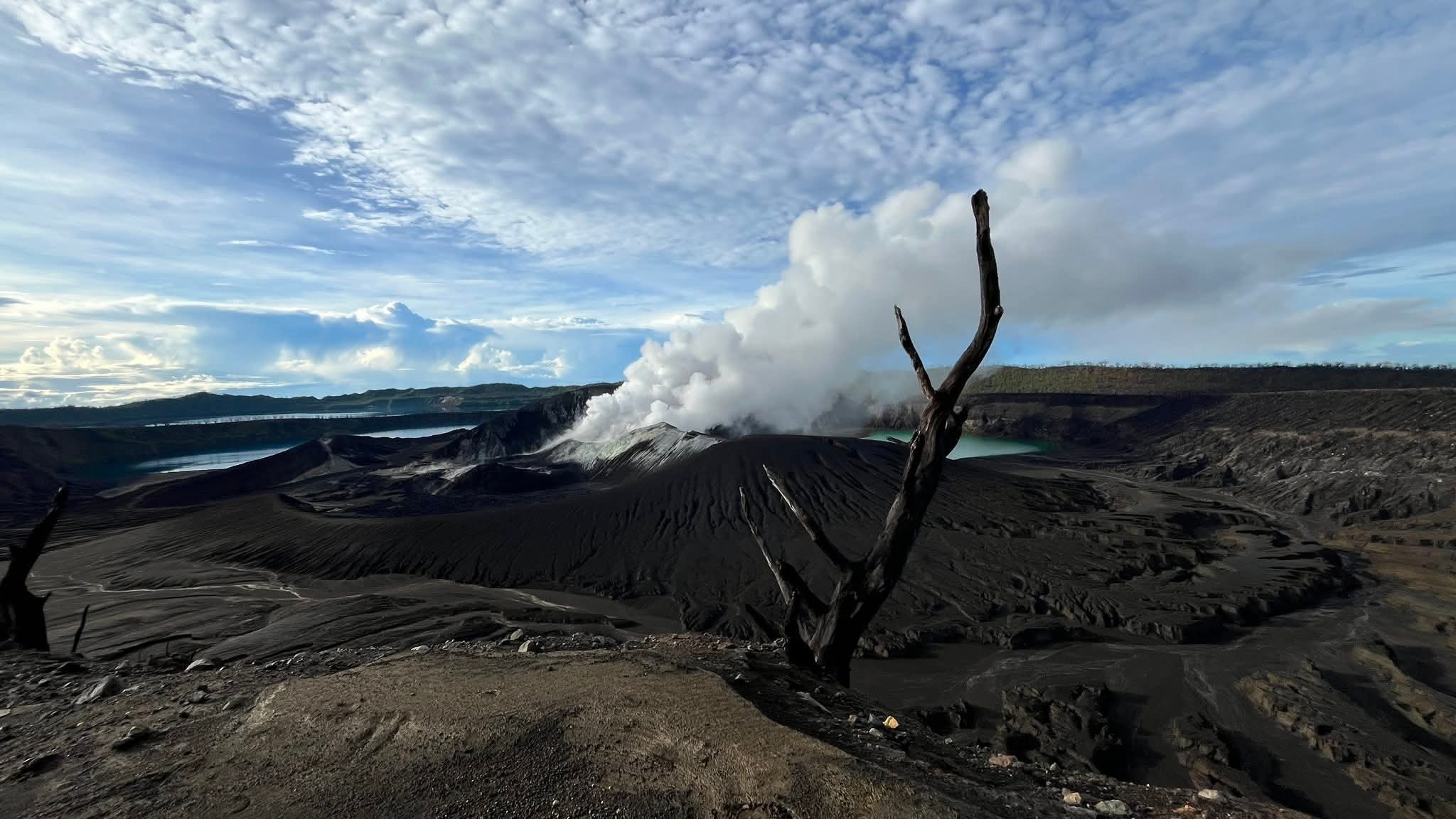
Observation photos taken by the webcam on May 1, 2025 shows that Ambae’s volcanic activity consists of continuous emissions of steam cloud, which may contain water vapor (steam) and/or gases. Satellite images from May 2025 shows evidence of continued sulfur dioxide (SO2) volcanic degassing. The satellite image from May 1, 2025, also showed evidence of a low thermal anomaly detection at Ambae volcano, indicating an increase in surface temperature around the volcano due to the presence of magma near the Earth’s surface. Seismic data analysis has also confirmed the ongoing major volcanic unrest activity on Ambae.
The Ambae volcanic alert level has been at Level 2 since 27th December 2021. Observations of the current activity are consistent with the Volcanic Alert Level 2. Level 2 indicates “Major unrest, with a volcanic hazards danger zone of 2 km radius from active volcanic vents”. With this current volcanic activity, it is a useful reminder that eruptions can occur with little or no warnings.
Source : Geohazard
Photo : Sue Ireland via Wulkany swiata.