June 19 , 2025.
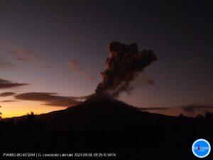
Indonesia , Lewotobi Laki-laki :
The Pusat Vulkanologi dan Mitigasi Bencana Geologi (PVMBG) reported that continuing low-level unrest and steam plumes from Lewotobi Laki-laki ended with a large explosive eruption on 17 June. Deep volcanic earthquakes increased from an average of 8-10 daily events to 50 events in two hours early on 17 June. After analysis of visual and instrumental data, the Alert Level was raised to 3 (on a scale of 1-4) at 07h00 on 17 June and then raised again to level 4 at 15h00; the public was warned to stay 8 km away from the summit.
A large explosive eruption at 17h35 on 17 June produced a dense ash plume that rose 10 km above the summit (based on initial ground observer estimates) and resulted in pyroclastic flows down multiple flanks that were visible in a webcam image at 17h41. BNPB reported ashfall in several villages, including Boru (8 km WNW), Hewa (10 km SW), and Watobuku (7 km WNW). Some residents in Nurabelen (8 km SE), Ile Bura District, evacuated to sites in Konga (10 km N). Ashfall was also reported at the Monitoring Post in Pululera Village (8 km NW); post officers evacuated to the church about 1.2 km from the monitoring post. Several residents also evacuated to Nileknoheng Village (12 km NW).
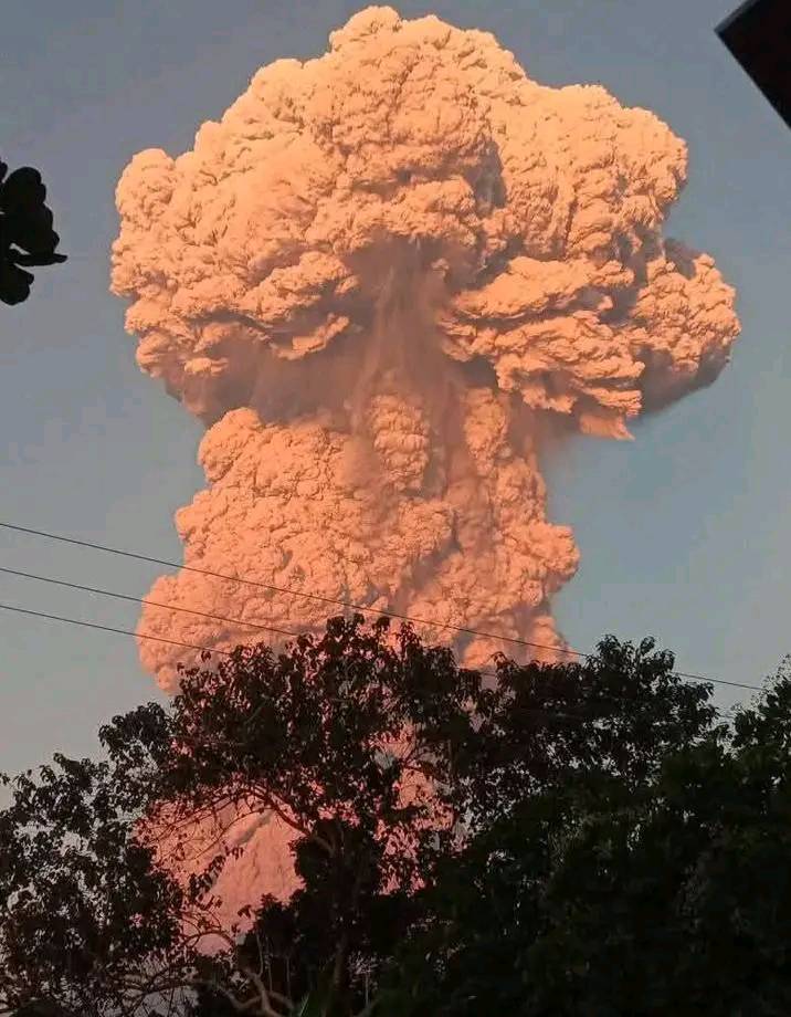
Subsequent gray ash plumes rose 2 km above the summit at 21h33 and 22h10 and drifted N and NE; another plume at 23h00 rose 5 km above the summit and drifted SW and W. Strong incandescence was visible at the summit in corresponding webcam images. On 18 June the I Gusti Ngurah Rai International Airport reported 17 outbound and 15 incoming flight cancelations due to the 17 June eruptive event. An aviation advisory from the Darwin VAAC at 09h40 on 18 June noted multiple ash plumes observed in satellite imagery, with the highest around 16 km and moving SW.
Sources: Pusat Vulkanologi dan Mitigasi Bencana Geologi (PVMBG, also known as CVGHM), Badan Nacional Penanggulangan Bencana (BNPB), Antara News, Darwin Volcanic Ash Advisory Centre (VAAC), GVP.
Photo : Maxi J Taniu .
Iceland , Reykjanes Peninsula :
Continued Uplift in Svartsengi
Update 18. June
The hazard map has been updated, and it will be valid until 15 July 2025. The map is almost unchanged from the previous one, but small editions may be worth noticing.
The area between Vogaheiði and Fagradals-Hagafell is now assessed to be at low hazard, while it was marked to be at moderate hazard before. The reason for this change is due to a mistake made while assigning the weight to the eruptive fissure hazard (which is now considered lower than before). The same applies to the Southwestern end of Zone A (Grindavík).
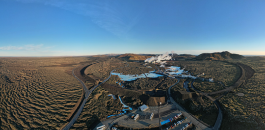
Hazard due to sinkholes is now listed as a potential hazard in Zone C (Vogar). This change is due to an oversight in checking the presence of fractures that occurred during the last event on 1 April. On that day the magmatic dike propagated much more to the NE of Stóra-Skógafell, but minor fractures in SE corner of this target zone were not initially spotted, as they became clearer after a double check.
Finally, it is important to note that the map wants to report on hazards which are assessed to be currently present and those which may occur given the status of unrest in the Svartsengi volcanic system.
Source : IMO
Photo : The Icelandic Met Office / Bjarki Kaldalóns Friis
Italy / Sicily , Etna :
Etna Activity Report, June 19, 2025, 6:01 AM (4:01 UTC)
The National Institute of Geophysics and Volcanology, Osservatorio Etneo, reports that explosive activity was observed at the Southeast Crater starting at 23:25 UTC on June 18. The forecast model indicates that any eruptive clouds produced by the ongoing activity would disperse northward. The presence of cloud cover limits detailed observation of the ongoing activity.
Around 9:00 PM (UTC) yesterday, the average amplitude of the volcanic tremor showed an increasing trend, albeit with an oscillatory tendency. This trend became much more pronounced starting at 2:00 AM (UTC) today, and at 2:40 AM (UTC), the amplitude values reached a high level.

The location of the centroid of the volcanic tremor sources is currently unreliable for technical reasons. The last reliable location placed the centroid in the Southeast Crater area. The location of infrasound events is also affected by technical issues, but for now, an increase in the number of modest-amplitude infrasound events is observed, likely located in the Southeast Crater.
Data from the DRUV dilatometer station and data available from the permanent GNSS network do not show any significant variations.
Updates will be provided shortly.
Source : INGV.
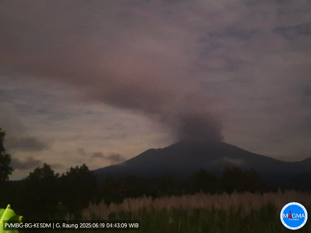
Indonesia , Raung :
Raung erupted on Thursday, June 19, 2025, at 4:43 a.m. WIB. The observed ash column was ± 2,000 m above the summit (± 5,332 m above sea level). The ash column was gray, moderate in intensity, and oriented toward the southeast and south. At the time of this report, the eruption was still ongoing.
VOLCANO OBSERVATORY NOTICE FOR AVIATION – VONA
Issued : June 18 , 2025
Volcano : Raung (263340)
Current Aviation Colour Code : ORANGE
Previous Aviation Colour Code : orange
Source : Raung Volcano Observatory
Notice Number : 2025RAU030
Volcano Location : S 08 deg 07 min 30 sec E 114 deg 02 min 31 sec
Area : East java, Indonesia
Summit Elevation : 10662 FT (3332 M)
Volcanic Activity Summary :
Eruption with volcanic ash cloud at 21h43 UTC (04h43 local).
Volcanic Cloud Height :
Best estimate of ash-cloud top is around 17062 FT (5332 M) above sea level or 6400 FT (2000 M) above summit. May be higher than what can be observed clearly. Source of height data: ground observer.
Other Volcanic Cloud Information :
Ash cloud moving from southeast to south. Volcanic ash is observed to be gray. The intensity of volcanic ash is observed to be medium.
Remarks :
Tremor recorded on seismogram with maximum amplitude 4 mm.
The Pusat Vulkanologi dan Mitigasi Bencana Geologi (PVMBG) reported that the eruption continued at Raung during 11-17 June. Plumes were reported on 11 June reaching 750 m above the summit and drifting E, NE, and W. On 12 June PVMBG issued a special report noting that ongoing eruptions had increased in intensity and that ash plumes were rising approximately 1,000 m above the summit. Moderate eruptions continued on 13 June, with the plume drifting S, SW, and W. On 14 June the plume height was reported as 1,500 m, and on 15 June the plume height was 1,200 m. The Alert Level remained at 2 (on a scale of 1-4) and the public was warned to stay 3 km away from the summit crater.
Sources : Magma Indonésie , GVP.
Photo : Magma Indonésie
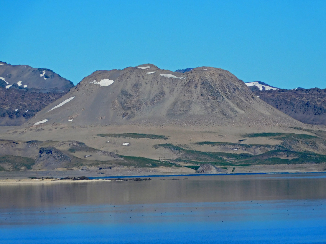
Chile , Laguna del Maule :
Special Report on Volcanic Activity (REAV), Maule Regions, Laguna del Maule Volcanic Complex, June 18, 2025, 9:40 a.m. local time (Continental Chile)
The National Geology and Mining Service of Chile (SERNAGEOMIN) announces the following preliminary information, obtained using the monitoring equipment of the National Volcanic Monitoring Network (RNVV), processed and analyzed at the Southern Andean Volcano Observatory (OVDAS):
On Wednesday, June 18, 2025, at 8:20 a.m. (12:20 UTC), monitoring stations installed near the Laguna del Maule volcanic complex recorded an increase in the occurrence of volcano-tectonic earthquakes (associated with rock fracturing within the volcanic system), reaching a total of 208 earthquakes in the last few hours, characterizing this episode. seismic as a swarm of volcano-tectonic type earthquakes.
The earthquake characteristics after analysis are as follows:
TIME OF ORIGIN: 09:10 local time (13:10 UTC)
LATITUDE: 36.1141° S
LONGITUDE: 70.5493° W
DEPTH: 3.6 km
LOCAL MAGNITUDE: 0.5 (ML)
Observation:
This seismic swarm is characterized by a high frequency of low-energy volcano-tectonic (VT) events. At the time of this report, seismic events are still being recorded.
The Volcanic Technical Alert remains at GREEN.
Source : Sernageomin
Photo : Álvaro Vivanco – Volcán Domos del Maule.