October 24 , 2024 .
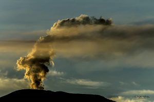
Alaska , Spurr :
No major changes were detected in the past day at Mount Spurr. Seismicity remains elevated with several small earthquakes detected. No unusual activity was observed in cloudy satellite or web camera data over the past day.
AVO continues to closely monitor activity at Mount Spurr for signals that would indicate that the volcano is moving closer to an eruption. Based on previous eruptions, changes from current activity in the earthquakes, ground deformation, summit lake, and fumaroles would be expected if magma began to move closer to the surface. Therefore, it is very likely that if an eruption were to occur it would be proceeded by additional signals that would allow advance warning.
Local seismic, infrasound, web cameras, and GNSS stations are used to monitor Mount Spurr along with regional infrasound, lightning networks and satellite data.
The Alaska Volcano Observatory (AVO) reported that low-level unrest at Spurr was ongoing, characterized by elevated seismicity and deformation, and minor gas-and-steam emissions were visible in webcams. A small lake was present in the summit crater during 15 May to 15 June. The Volcano Alert Level was raised to Advisory (the second highest level on a four-level scale) and the Aviation Color Code was raised to Yellow (the second highest level on a four-color scale) at 12h37 on 16 October.
Source: US Geological Survey Alaska Volcano Observatory (AVO) , GVP.
Photo : Botnick, Steven / AVO / U.S. Geological Survey ( 09/2021)
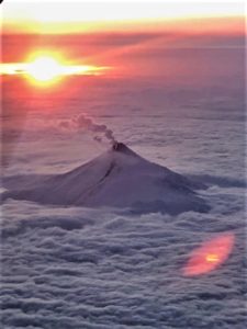
Indonesia , Lewotobi Laki-laki :
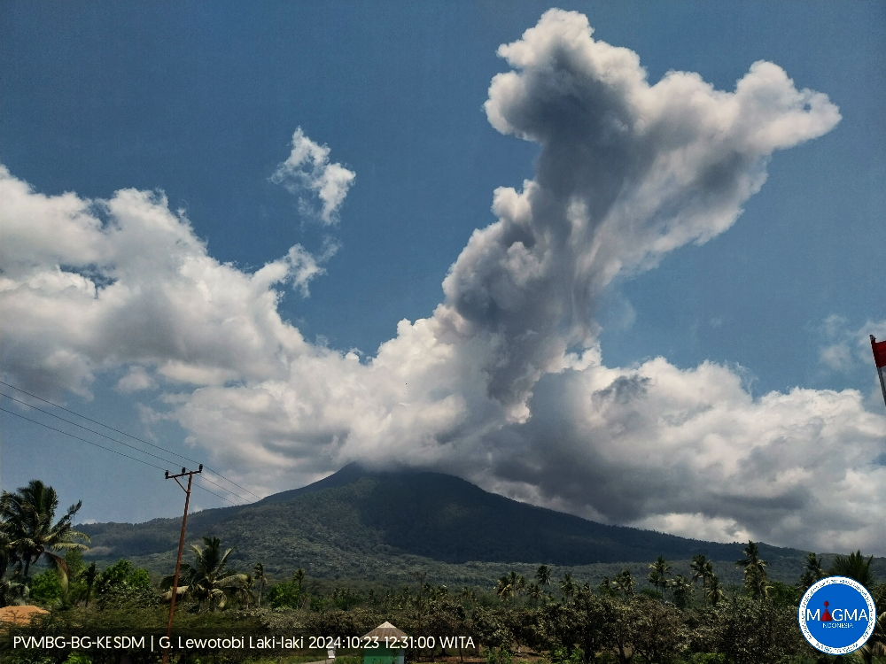
An eruption of Mount Lewotobi Laki occurred on Wednesday, October 23, 2024 at 12:23 WITA with the height of the ash column observed at ± 800 m above the summit (± 2384 m above sea level). The ash column was observed to be gray with a thick intensity, oriented to the West and Northwest. This eruption was recorded on a seismograph with a maximum amplitude of 7.4 mm and a duration of 440 seconds.
VOLCANO OBSERVATORY NOTICE FOR AVIATION – VONA
Issued : October 23 , 2024
Volcano : Lewotobi Laki-laki (264180)
Current Aviation Colour Code : ORANGE
Previous Aviation Colour Code : orange
Source : Lewotobi Laki-laki Volcano Observatory
Notice Number : 2024LWK666
Volcano Location : S 08 deg 32 min 20 sec E 122 deg 46 min 06 sec
Area : East Nusa Tenggara, Indonesia
Summit Elevation : 5069 FT (1584 M)
Volcanic Activity Summary :
Eruption with volcanic ash cloud at 04h23 UTC (12h23 local).
Volcanic Cloud Height :
Best estimate of ash-cloud top is around 7629 FT (2384 M) above sea level or 2560 FT (800 M) above summit. May be higher than what can be observed clearly. Source of height data: ground observer.
Other Volcanic Cloud Information :
Ash cloud moving from west to northwest. Volcanic ash is observed to be gray. The intensity of volcanic ash is observed to be thick.
Remarks :
Eruption recorded on seismogram with maximum amplitude 7.4 mm and maximum duration 440 second.
Source et photo : Magma Indonésie.
Mexico , Popocatepetl :
October 23, 11:00 (October 23, 17:00 GMT) . Activity in the last 24 hours
22 exhalations were detected, accompanied by water vapor, volcanic gases and ash. . In addition, 1,007 minutes of very low to low amplitude high frequency tremor segments were counted, totaling 16.78 hours.
At the time of writing, there is no evidence or information of ash fall. However, during the morning, a continuous emission of light ash, water vapor and volcanic gases was observed, with dispersion towards the Northwest (NNW).
The Popocatépetl volcanic alert fire is at yellow phase 2.
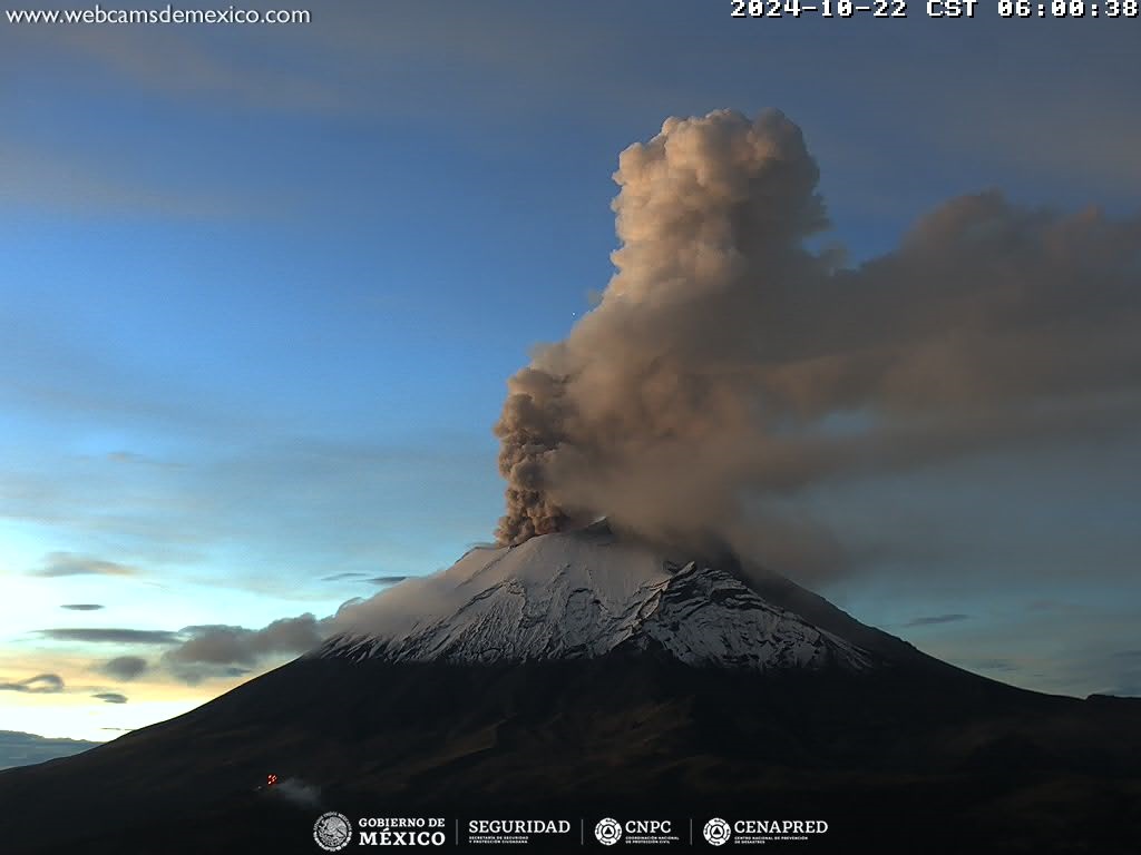
Centro Nacional de Prevención de Desastres (CENAPRED) reported that eruptive activity continued at Popocatépetl during 16-22 October. The seismic network recorded 9-89 long-period events per day that were accompanied by steam-and-gas emissions. The seismic network also recorded daily tremor with periods lasting from 54 minutes up to 13 hours and 17 minutes, and a period of emissions that lasted 35 minutes during 15-16 October. Two volcano-tectonic earthquakes were recorded during 01h00-02h00 on 16 October. A single volcano-tectonic earthquake was detected at 16h39 on 20 October. A significant tremor episode that began at 11h47 was accompanied by a gas-and-ash plume that rose 2 km above the crater and incandescent material that was ejected a short distance from the crater. Based on information from El Centro Nacional de Comunicación y Operación de Protección Civil (CENACOM) ashfall was reported in Ozumba (18 km W), Tlalmanalco (30 km NW), and Ecatzingo (15 km SW) in the state of Mexico; and around 0958 in Tlalnepantla (80 km NW), Tlayacapan (40 km WSW), and Totolapan in the state of Morelos.
According to the Washington VAAC ash plumes visible in webcam and satellite images during 17-21 October rose to 5.8-7.3 km (19,000-24,000 ft) a.s.l. and drifted in different directions. The Alert Level remained at Yellow, Phase Two (the middle level on a three-color scale) and the public was warned to stay 12 km away from the crater.
Sources: Centro Nacional de Prevencion de Desastres (CENAPRED), Washington Volcanic Ash Advisory Center (VAAC) , GVP.
Chile , Laguna del Maule :
Special Report on Volcanic Activity (REAV), Maule Regions, Laguna del Maule Volcanic Complex, October 24, 2024, 01:43 local time (Continental Chile)
The National Geology and Mining Service of Chile (Sernageomin) announces the following PRELIMINARY information, obtained through the monitoring equipment of the National Volcanic Monitoring Network (RNVV), processed and analyzed at the Southern Andean Volcano Observatory (Ovdas):
On Thursday, October 24 at 01:23 (04:23 UTC), the monitoring stations installed near the Laguna del Maule volcanic complex recorded a volcano-tectonic earthquake (associated with rock fracturing). At the time of this report, nearly 100 localized events have been recorded.
The characteristics of the largest earthquake after its analysis are as follows:
TIME OF ORIGIN: 01:23 local time (04:23 UTC)
LATITUDE: 36.081° S
LONGITUDE: 70.512° West
DEPTH: 7.9 km
LOCAL MAGNITUDE: 4.6 (ML)
Observation:
At the time of this report, an increase in volcano-tectonic activity is observed, with earthquakes of low to moderate energy.
On Thursday, October 24 at 03:03 (06:03 UTC), monitoring stations installed near the Laguna del Maule volcanic complex recorded a swarm of volcano-tectonic earthquakes (associated with rock fracturing).
TIME OF ORIGIN: 01:52 local time (04:52 UTC)
LATITUDE: 36.109° S
LONGITUDE: 70.499° West
DEPTH: 7.9 km
LOCAL MAGNITUDE:
As mentioned in previous reports, following the M4.6 event, an increase in volcano-tectonic activity was recorded on the Laguna del Maule volcanic complex, with low to moderate energy earthquakes. At the time of this report, volcano-tectonic activity continues to be recorded.
The volcanic technical alert remains at GREEN level.
Source : Sernageomin
Photo : OAVV
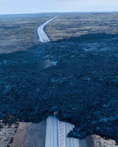
République Démocratique du Congo , Nyamulagira :
The Observatoire Volcanologique de Goma (OVG) reported that lava effusion at Nyamulagira was continuing. According to a special bulletin issued on 2 October, three lava flows were active on the N and W flanks, with the longest reaching 7 km NW from the crater rim. Strong seismicity in the area was also reported in a special bulletin issued on 14 October. During the nights of 13 and 14 October an intense glow was visible in the crater.

Africa’s most active volcano, Nyamulagira (also known as Nyamuragira), is a massive high-potassium basaltic shield about 25 km N of Lake Kivu and 13 km NNW of the steep-sided Nyiragongo volcano. The summit is truncated by a small 2 x 2.3 km caldera that has walls up to about 100 m high. Documented eruptions have occurred within the summit caldera, as well as from the numerous flank fissures and cinder cones. A lava lake in the summit crater, active since at least 1921, drained in 1938, at the time of a major flank eruption. Recent lava flows extend down the flanks more than 30 km from the summit as far as Lake Kivu; extensive lava flows from this volcano have covered 1,500 km2 of the western branch of the East African Rift.
Sources : Observatoire Volcanologique de Goma (OVG) , GVP.
Photo : Monusco ( 07/2015)