November 12 , 2020.
India / Andaman Islands : Barren Island ,
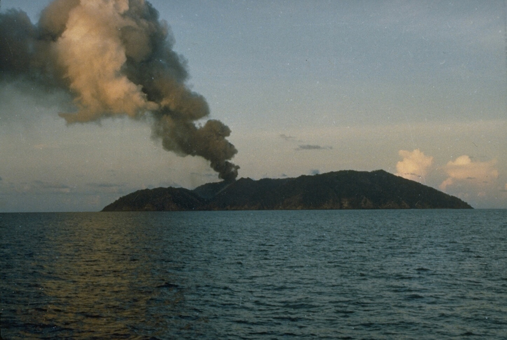
The Darwin VAAC reported that an eruption at Barren Island on 5 November produced ash plumes that rose 1.5 km (5,000 ft) a.s.l. and drifted SW and WSW.
An ash plume in 1991 rises above Barren Island along the volcanic arc connecting north of Sumatra. The 3-km-wide island contains a 1.6-km-wide crater that is partially filled by a scoria cone that has been the source of eruptions since the first was recorded in 1787. Lava flows reached the coast during several recent eruptions.
Barren Island, a possession of India in the Andaman Sea about 135 km NE of Port Blair in the Andaman Islands, is the only historically active volcano along the N-S volcanic arc extending between Sumatra and Burma (Myanmar). It is the emergent summit of a volcano that rises from a depth of about 2250 m. The small, uninhabited 3-km-wide island contains a roughly 2-km-wide caldera with walls 250-350 m high. The caldera, which is open to the sea on the west, was created during a major explosive eruption in the late Pleistocene that produced pyroclastic-flow and -surge deposits. Historical eruptions have changed the morphology of the pyroclastic cone in the center of the caldera, and lava flows that fill much of the caldera floor have reached the sea along the western coast.
Source : GVP , Darwin Volcanic Ash Advisory Centre (VAAC).
Photo : D. Haldar, 1991 (Geological Survey of India).
Japan , Sakurajima :
JMA reported that during 2-9 November incandescence from Minamidake Crater (at Aira Caldera’s Sakurajima volcano) was visible nightly. Two explosions during 1-2 November produced ash plumes that rose as high as 1.8 km above the crater rim. An explosion was recorded at 1504 on 7 November but the weather conditions prevented visual conformation. The daily sulfur dioxide emission rate was high at 2,200 tons per day on 9 November. The Alert Level remained at 3 (on a 5-level scale).
The Aira caldera in the northern half of Kagoshima Bay contains the post-caldera Sakurajima volcano, one of Japan’s most active. Eruption of the voluminous Ito pyroclastic flow accompanied formation of the 17 x 23 km caldera about 22,000 years ago. The smaller Wakamiko caldera was formed during the early Holocene in the NE corner of the Aira caldera, along with several post-caldera cones. The construction of Sakurajima began about 13,000 years ago on the southern rim of Aira caldera and built an island that was finally joined to the Osumi Peninsula during the major explosive and effusive eruption of 1914. Activity at the Kitadake summit cone ended about 4850 years ago, after which eruptions took place at Minamidake. Frequent historical eruptions, recorded since the 8th century, have deposited ash on Kagoshima, one of Kyushu’s largest cities, located across Kagoshima Bay only 8 km from the summit. The largest historical eruption took place during 1471-76.
Source:Japan Meteorological Agency (JMA) , GVP.
Photo : 8nov19 , @volcanohull / public domain / Volcanodiscovery
Costa Rica , Turrialba / Poas / Rincon de la Vieja / Irazu :
Weekly bulletin, November 9, 2020.
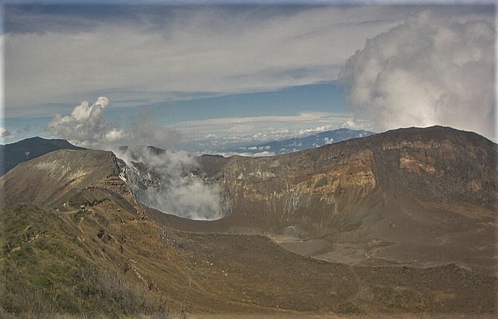
Turrialba volcano
Lat: 10.025 ° N; Long: 83.767 ° W;
Height: 3340 m.s.n.m.
Current activity level: 2 (active volcano)
Potentially associated hazards: gas, ash emission, proximal ballistic projections.
No ash emission was observed. The seismic activity remains high with LP type events and short tremors. Geodetic observations continue to detect horizontal contraction of the Turrialba-Irazú massif, and they have noted significant deflation in recent days. Gas ratios or SO2 flow could not be measured due to unfavorable wind direction.
No thermal anomaly was detected by the MODIS analysis. The high level of seismicity is interpreted as infiltration of rainwater into the building, which, if confirmed, could produce small ash emissions and groundwater eruptions capable of proximal ballistic projections.
Poas volcano
Lat: 10.2 ° N; Long: 84.233 ° W;
Height: 2780 m.s.n.m.
Current activity level: 2 (active volcano)
Potentially associated hazards: gas, phreatic eruptions, proximal ballistic projections.
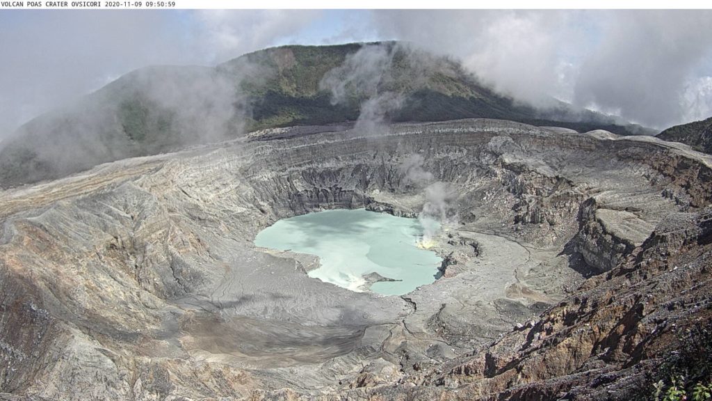
No eruption was detected. The seismic activity continues with more permanent background tremors of varying amplitude. Inflation observed by geodetic monitoring since August has decreased, now it is no longer significant. The H2S / SO2 ratio remains high and the SO2 / CO2 ratio remains low. These measurements are consistent with the observation of elemental sulfur floating in the lake during the week. The SO2 flux could not be measured due to an unfavorable wind direction. The level of the lake rose 1.4 m in one week due to heavy rainfall (~ 450 mm under the influence of Hurricane Eta). Evaporation / infiltration rate has decreased. No thermal anomaly was detected by the MODIS analysis.
Rincon de la Vieja volcano
Lat: 10.83 ° N; Long: 85.324 ° W;
Height: 1895 m.s.n.m.
Current activity level: 3 (erupting volcano)
Potentially associated hazards: gas, phreatic eruptions, proximal ballistic projections, lahars.
Seismic activity is low. The eruptions are more sporadic but with a greater amplitude. Geodetic monitoring shows a significant narrowing of the summit of the volcano.
No thermal anomaly was detected by the MODIS analysis.
At 5:40:00 local time on November 11, 2020, an eruption was recorded on the Rincon de la Vieja volcano, with a column that rose 1,000 meters above the height of the crater and 2,916 meters above above sea level (9,564.48 ft).
Duration of activity: 5 minutes.
Irazu volcano
Lat: 9.979 ° N; Long: 83.852 ° W;
Altitude: 3432 m.s.n.m.
Current activity level: 1 (active)
Potentially associated hazards: landslides.
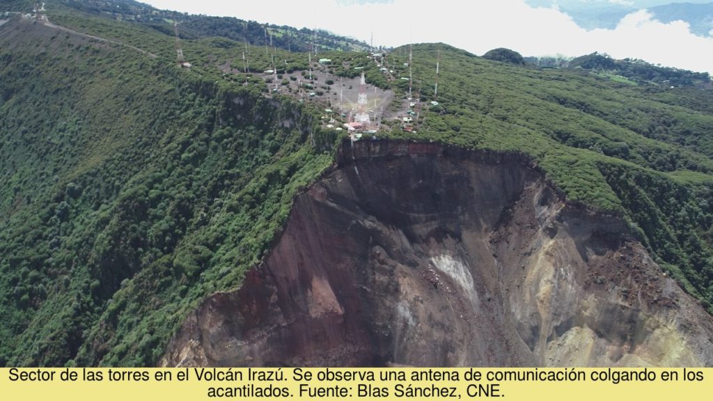
Seismic monitoring detected a significant landslide on November 4 with a lahar-type flood (mud runoff). The main landslide in the western sector of the volcano presented a vertical acceleration during the weekend, without being associated with an acceleration on the horizontal components. MODIS satellite analysis detected a small thermal anomaly on November 4.
Source : Ovsicori .
Chile , Laguna del Maule :
SERNAGEOMIN reported that 10 low-magnitude volcano-tectonic earthquakes were detected at the Laguna del Maule Volcanic Complex during 16-31 October; seismicity was low in the region where a swarm had occurred in June. Satellite data showed no deformation, surface changes, gas emissions, or thermal anomalies. On 6 November the Alert Level was lowered to Green, the lowest level on a four-color scale. ONEMI cancelled the Yellow Alert for San Clemente, but declared a “Preventive Early Warning” ensuring continued surveillance of the area and coordination within the Civil Protection System.
– 10 seismic events classified as volcano-tectonic (VT) were recorded, associated with fracture processes of rigid materials in volcanic systems. No event presented a level of energy to locate it.
– The images provided by the IP camera installed near the complex did not record any surface activity associated with the volcanic system.
– Thanks to the analysis of Sentinel L2 A and Planet Scope satellite images, no surface or morphological variation is observed. There are also no variations in temperature or radiances associated with thermal anomalies, according to the LandSat 8 OLI TIIRS and Sentinel L2 A image processing.
– No anomalies were reported in the emissions of sulfur dioxide (SO2) into the atmosphere in the area near the volcanic complex, according to data published by the Tropospheric Monitoring Instrument (TROPOMI) and the Ozone Monitoring Instrument (OMI ) Sulfur Dioxide Group (http: //so2.gsfc.nasa.gov/).
– During the period, no thermal alert was recorded in the area associated with the volcanic complex, according to data processed by Middle Infrared Observation of Volcanic Activity (MIROVA) and by temporal thermal monitoring of global hot spots (MODVOLC) (http://modis.higp.hawaii.edu/).
– Data for the geodesic assessment of the volcanic complex was not available due to problems originally. The interferometric data make it possible to detect behavior similar to that observed historically in the area, without evidence of notable changes in the behavior of the complex.
Despite the recording of low energy seismic activity in the area where the seismic swarms occurred in June of this year, no new high seismic recurrence events were observed in the area. The above, along with the analysis of satellite images, where no variation or surface anomaly is observed, suggests stability in the volcanic complex.
The above allows to change the volcanic alert level to:
GREEN TECHNICAL ALERT: Active volcano with stable behavior – No immediate risk.
Source : GVP , Sernageomin .
Photo : Oscar González-Ferrán (University of Chile)

