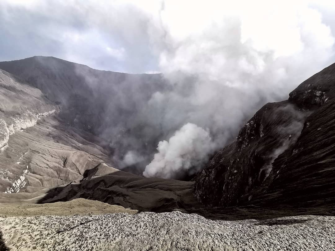
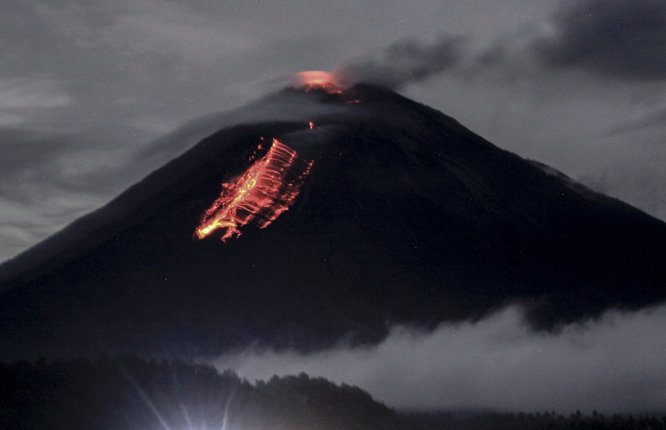
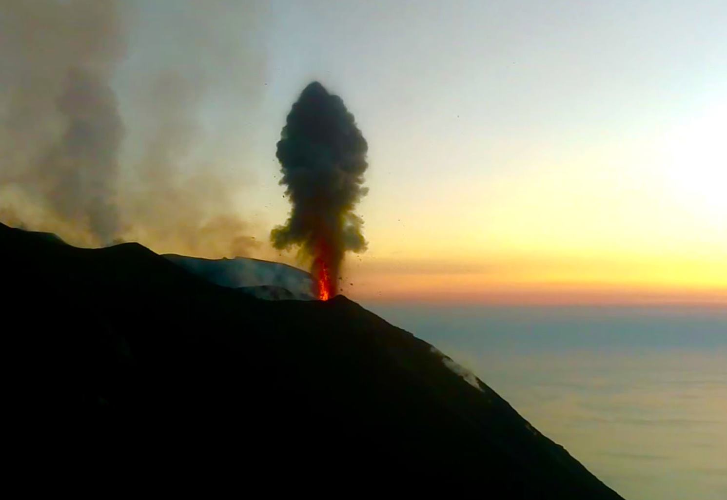
April 30, 2020. EN. Italy : Stromboli , Colombia : Nevado del Ruiz , Japan : Suwanosejima , Indonesia : Dukono .

April 30 , 2020.


Italy , Stromboli : 

Weekly bulletin from April 20, 2020 to April 26, 2020 (issue date April 28, 2020)

SUMMARY OF ACTIVITY STATUS

In light of the monitoring data, it is highlighted:
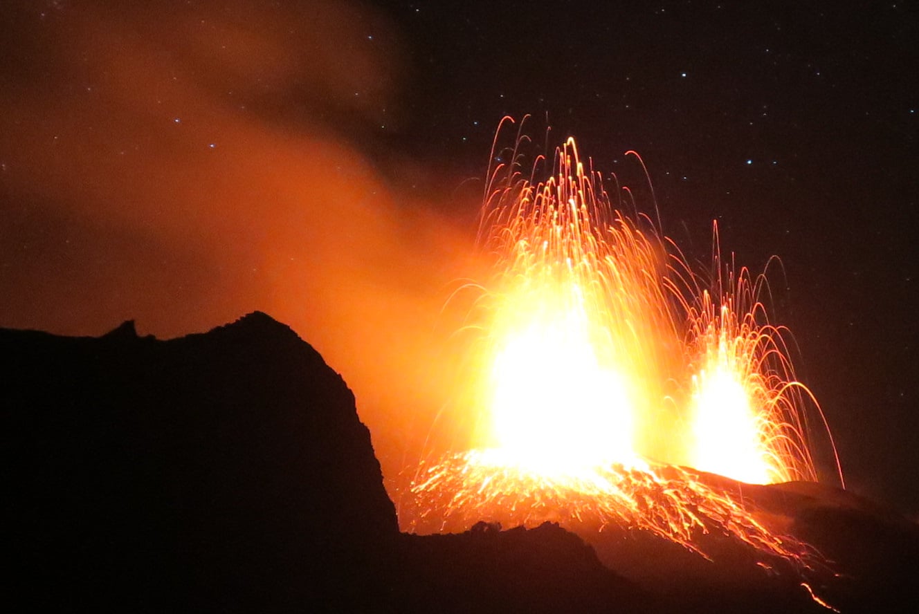
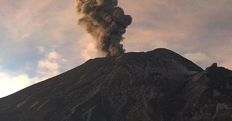
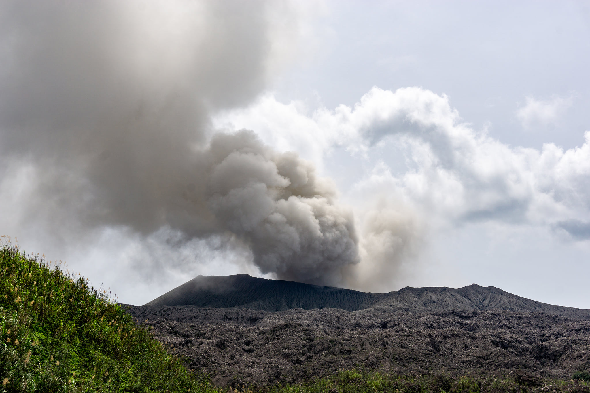
1) VOLCANOLOGICAL OBSERVATIONS: During this period, normal Strombolian type explosive activity was observed, accompanied by degassing and splashing activities. The hourly frequency of explosions fluctuated between medium-high values ​​(15 events / h on April 22) and high values ​​(22 events / h on April 20 and 25). The intensity of the explosions was mainly medium-low in the area of ​​the North crater and medium-high in the area of ​​the Center-South crater.
2) SEISMOLOGY: The seismological parameters do not show significant variations.
4) DEFORMATIONS: Data from the Stromboli soil deformation monitoring networks did not show significant changes last week.
5) GEOCHEMISTRY: The flow of SO2 is at an average level. The last measurement of the CO2 / SO2 ratio is at an average value (last update on 02/09/2020). The isotopic ratio of helium remains on average values ​​(last update of 09/03/2020). There is no update on the CO2 released by the soil.
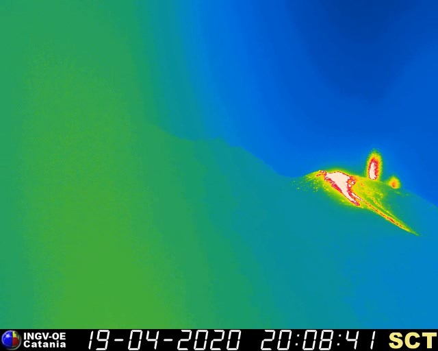
6) SATELLITE OBSERVATIONS: The thermal activity in the summit area is low.

VOLCANOLOGICAL OBSERVATIONS.
The analysis of the images recorded by the cameras placed at an altitude of 400m, at an altitude of 190m and at Punta dei Corvi made it possible to characterize the eruptive activity of Stromboli. During the reporting period, the explosive activity was mainly produced by at least 4 (four) eruptive vents located in the area of the North crater and by at least 2 (two) eruptive vents located in the area of the Center-South crater . All the vents are located inside the depression which occupies the crater terrace.

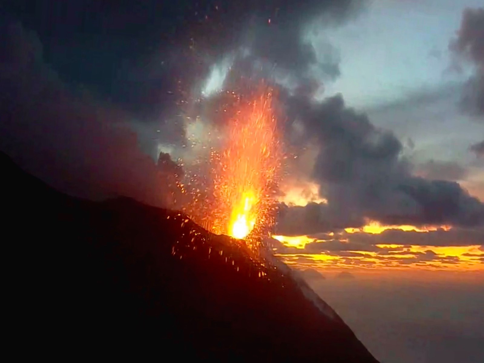
In the North zone, the explosions were mainly of variable intensity, from low (less than 80 m in height) to high (more than 150 m in height) emitting coarse materials (lapilli and bombs). In numerous explosions, the abundant fallout covered the outer slopes of the area overlooking the Sciara del Fuoco and the blocks rolled until they reached the coast. In addition, splashes were observed on April 20 and 21, which were intense mid-day on April 21. The average frequency of explosions in the North zone varied between 7 and 14 events / h. The explosive activity of the Center-South zone produced explosions of mainly fine materials (ashes) mixed with coarse particles of medium intensity (less than 150 m in height) sometimes high (the products exceed 250 m in height). Frequency of explosions in the Center-South zone varied between 7 and 10 events / h.

The amplitude of the volcanic tremor generally had medium-low values

Source : INGV.

Read the whole article : http://www.ct.ingv.it/joomlatools-files/docman-files/multidisciplinari/BollettinoStromboli20200428.pdf?fbclid=IwAR34PCcoSDOOr-aH3I0NwxbtgeGXZcjABScbJ3u2ksLc6PGcrUt7FRP9gqk

Photos : Web Cam.


Colombia , Nevado del Ruiz :

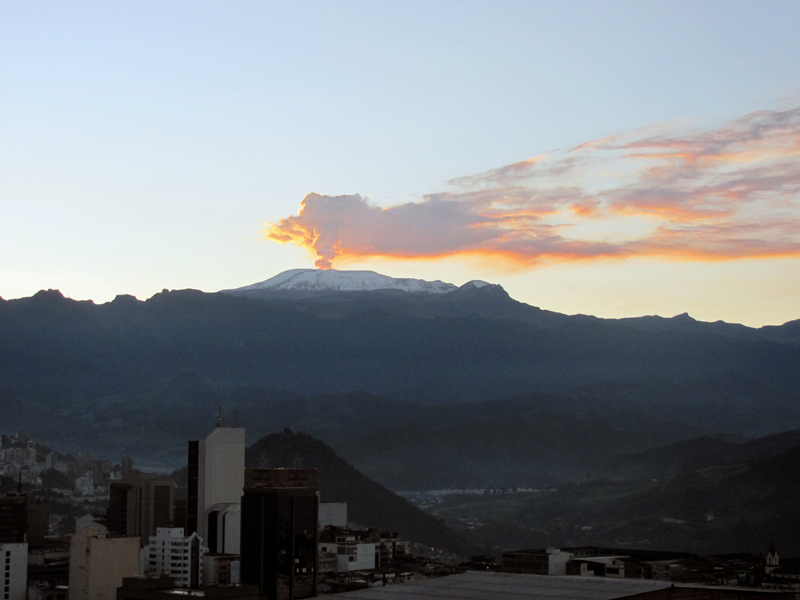
Weekly activity bulletin of the Nevado del Ruiz volcano

The level of activity continues at the level of yellow activity or (III): changes in the behavior of volcanic activity.

With regard to monitoring the activity of the Nevado del Ruiz volcano, the COLOMBIAN GEOLOGICAL SERVICE reports that:
The seismicity linked to the dynamics of the fluids inside the volcanic conduits presented similar levels as well in the number of recorded events as in the seismic energy released, compared to the previous week. This seismic activity has been characterized by the occurrence of continuous volcanic tremors, tremor pulses, long period and very long period earthquakes. These earthquakes presented varying energy levels and spectral contents. Some of these signals were associated with small emissions of gas and ash, which were confirmed by cameras installed in the volcano area and by reports from officials of the Los Nevados National Natural Park in the region.

The seismicity generated by the fracturing of the rocks showed a slight increase in the number of earthquakes and similar levels of released seismic energy, compared to the previous week. This type of seismicity was mainly located in the Arenas crater and in the Northeast, Southwest, Southeast sectors and to a lesser extent North and North West of the volcano, at depths between 0.6 and 5.8 km. The maximum magnitude recorded during the week was 1.5 ML (local magnitude) corresponding to the earthquake recorded on April 22 at 00:42 (local time), located in the Arenas crater, 1.8 km deep.

The occurrence of a seismic episode of the « drumbeat » type, earthquakes associated with rock fracturing, on April 23 is highlighted. This episode was characterized by its low energy level.

The deformation of the volcanic surface, measured from GNSS stations (Global Navigation Satellite System), showed some changes, associated with volcanic activity, consistent with those recorded by the other volcanic monitoring parameters, used during the evaluation complete activity of Nevado del Ruiz.

By monitoring the information provided on the Mirova and NASA FIRMS web portals, low-energy thermal anomalies on the volcano have been reported in the past week.

Source : SGC .

Photos : archivo/Caracol Radio


Japan , Suwanosejima :

29.638°N, 129.714°E
Elevation 796 m

JMA reported that during 17-24 April incandescence from Suwanosejima’s Ontake Crater was visible nightly. Small eruptions occasionally occurred, along with an explosion on 24 April, producing gray-white plumes that rose as high as 600 m above the crater rim and ejected material as far as 600 m from the crater. Rumbling sounds were noted in a village 4 km SSW. The Alert Level remained at 2 (on a 5-level scale).

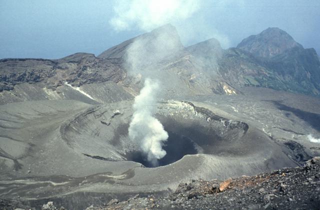
A steam plume rises above On-take, the summit crater of Suwanose-jima volcano. The 8-km-long, spindle-shaped island of Suwanose-jima consists of a stratovolcano with two historically active summit craters. The dipping escarpment at the top of the photo is the NW wall of a large breached crater that extends to the sea on the east flank. The horseshoe-shaped crater was formed by edifice collapse. Suwanose-jima, one of Japan’s most frequently active volcanoes, has been in a state of intermittent strombolian activity since 1949.

The 8-km-long, spindle-shaped island of Suwanosejima in the northern Ryukyu Islands consists of an andesitic stratovolcano with two historically active summit craters. The summit of the volcano is truncated by a large breached crater extending to the sea on the east flank that was formed by edifice collapse. Suwanosejima, one of Japan’s most frequently active volcanoes, was in a state of intermittent strombolian activity from Otake, the NE summit crater, that began in 1949 and lasted until 1996, after which periods of inactivity lengthened. The largest historical eruption took place in 1813-14, when thick scoria deposits blanketed residential areas, and the SW crater produced two lava flows that reached the western coast. At the end of the eruption the summit of Otake collapsed forming a large debris avalanche and creating the horseshoe-shaped Sakuchi caldera, which extends to the eastern coast. The island remained uninhabited for about 70 years after the 1813-1814 eruption. Lava flows reached the eastern coast of the island in 1884. Only about 50 people live on the island.

Source: Japan Meteorological Agency (JMA) , GVP.

Photo : Yukio Hayakawa, 1998 (Université Gunma).


Indonesia , Dukono :

1.693°N, 127.894°E
Elevation 1229 m

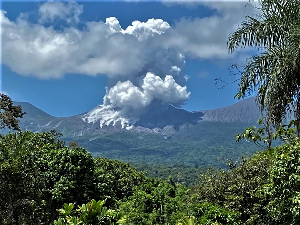
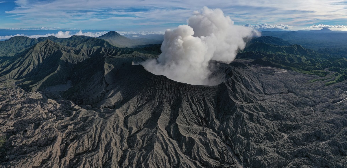
Based on satellite and wind model data, the Darwin VAAC reported that during 22-28 April ash plumes from Dukono rose to 2.1 km (7,000 ft) a.s.l. and drifted in multiple directions. The Alert Level remained at 2 (on a scale of 1-4), and the public was warned to remain outside of the 2-km exclusion zone.

Level II activity level (WASPADA). Mount Dukono (1229 m above sea level) is experiencing a continuous eruption. The last eruption occurred on April 29, 2020 with an eruption column height of 400 meters above the summit.
The volcano is clearly visible until it is covered with fog. The smoke from the crater is observed white / gray in color with a strong, thick intensity, about 200-500 meters above the summit. The weather is sunny / rainy, the wind is weak towards the South.

According to the seismographs of April 29, 2020, it was recorded:
1 local tectonic earthquake
Continuous tremor, amplitude 0.5 to 10 mm (dominant value 2 mm)

Recommendation:
The community around G. Dukono and visitors / tourists must not move, climb and approach the crater of Malupang Warirang within a radius of 2 km.
Since volcanic ash eruptions occur periodically and the ash dispersion follows the wind direction and speed, when the ash is not fixed, it is recommended that the community around G. Dukono always wear masks / nose and mouth cover to be used when necessary to avoid the danger of volcanic ash in the respiratory system.

VOLCANO OBSERVATORY NOTICE FOR AVIATION – VONA.

Issued: 20200429/0046Z
Volcano: Dukono (268010)
Current Aviation Colour Code: ORANGE
Previous Aviation Colour Code: orange
Source: Dukono Volcano Observatory
Notice Number: 2020DUK27
Volcano Location: N 01 deg 41 min 35 sec E 127 deg 53 min 38 sec
Area: North Maluku, Indonesia
Summit Elevation: 3933 FT (1229 M)

Volcanic Activity Summary:
Eruption with volcanic ash cloud at 23h20 UTC (08h20 local).

Volcanic Cloud Height:
Best estimate of ash-cloud top is around 5213 FT (1629 M) above sea level, may be higher than what can be observed clearly. Source of height data: ground observer.

Other Volcanic Cloud Information:
Ash-cloud moving to south.

Remarks:
Eruption and ash emission is continuing

Sources : GVP , Magma Indonésie , PVMBG.

Photos : Martin Rietze ,  Claudio Jung.

30 Avril 2020. FR . Italie : Stromboli , Colombie : Nevado del Ruiz , Japon : Suwanosejima , Indonésie : Dukono .

30 Avril 2020.


Italie , Stromboli : 

Bulletin hebdomadaire du 20 Avril 2020 au 26 Avril 2020 (date d’émission 28 Avril 2020)

RÉSUMÉ DU STATUT D’ACTIVITÉ

À la lumière des données de surveillance, il est mis en évidence:

1) OBSERVATIONS VOLCANOLOGIQUES: Pendant cette période, une activité explosive normale de type Strombolienne a été observée, accompagnée d’activités de dégazage et d’éclaboussures. La fréquence horaire des explosions a oscillé entre des valeurs moyennes-élevées (15 événements / h le 22 avril) et des valeurs élevées (22 événements / h les 20 et 25 avril). L’intensité des explosions était principalement moyenne-faible dans la zone du cratère Nord et moyenne-élevée dans la zone du cratère Centre-Sud.
2) SISMOLOGIE: Les paramètres sismologiques ne montrent pas de variations significatives.
4) DÉFORMATIONS: Les données des réseaux de surveillance de la déformation des sols de Stromboli ne montraient pas de changements significatifs la semaine dernière.
5) GÉOCHIMIE: Le flux de SO2 est à un niveau moyen. La dernière mesure du rapport CO2 / SO2 se situe à une valeur moyenne (dernière mise à jour le 09/02/2020). Le rapport isotopique de l’hélium reste sur les valeurs moyennes (dernière mise à jour du 09/03/2020). Il n’y a pas de mise à jour concernant le CO2 diffusé par les sols.
6) OBSERVATIONS SATELLITES: L’activité thermique dans la zone du sommet est faible.

OBSERVATIONS VOLCANOLOGIQUES.
L’analyse des images enregistrées par les caméras placées à une altitude de 400m, à une altitude de 190m et à Punta dei Corvi a permis de caractériser l’activité éruptive de Stromboli. Au cours de la période considérée, l’activité explosive a été principalement produite par au moins 4 (quatre) évents éruptifs situés dans la zone du cratère Nord et par au moins 2 (deux) évents éruptifs situés dans la zone du cratère Centre-Sud. Tous les évents sont situés à l’intérieur de la dépression qui occupe la terrasse du cratère  .

Dans la zone Nord, les explosions étaient principalement d’intensité variable, de faible (moins de 80 m de hauteur) à haute (plus de 150 m de hauteur) émettant des matières grossières (lapilli et bombes). Lors de nombreuses explosions, les abondantes retombées ont couvert les pentes extérieures de la zone surplombant la Sciara del Fuoco et les blocs ont roulé jusqu’à ce qu’ils atteignent la côte. De plus, des éclaboussures ont été observées les 20 et 21 avril, qui étaient intenses à la mi-journée du 21 avril. La fréquence moyenne des explosions dans la zone Nord variait entre 7 et 14 événements / h . L’activité explosive de la zone Centre-Sud a produit des explosions de matières principalement fines (cendres) mélangées à des particules grossières d’intensité moyenne (moins de 150 m de hauteur) parfois élevée (les produits dépassent 250 m de hauteur) La fréquence des explosions de la zone Centre-Sud variait entre 7 et 10 événements / h  .

L’amplitude du tremor volcanique avait généralement des valeurs moyennes-basses

Source : INGV.

Lire l’article en entierhttp://www.ct.ingv.it/joomlatools-files/docman-files/multidisciplinari/BollettinoStromboli20200428.pdf?fbclid=IwAR34PCcoSDOOr-aH3I0NwxbtgeGXZcjABScbJ3u2ksLc6PGcrUt7FRP9gqk

Photos : Web Cam.


Colombie , Nevado del Ruiz :

Bulletin d’activité hebdomadaire du volcan Nevado del Ruiz
Le niveau d’activité se poursuit au niveau d’activité jaune ou (III): changements dans le comportement de l’activité volcanique.

En ce qui concerne la surveillance de l’activité du volcan Nevado del Ruiz, le COLOMBIAN GEOLOGICAL SERVICE signale que:

La sismicité liée à la dynamique des fluides à l’intérieur des conduits volcaniques a présenté des niveaux similaires tant dans le nombre d’événements enregistrés que dans l’énergie sismique libérée, par rapport à la semaine précédente. Cette activité sismique a été caractérisée par la survenue de tremors volcaniques continus, d’impulsions de tremor, de tremblements de terre de type longue période et de très longue période. Ces tremblements de terre ont présenté des niveaux d’énergie et des contenus spectraux variables. Certains de ces signaux étaient associés à de petites émissions de gaz et de cendres, qui ont été confirmées par des caméras installées dans la zone du volcan et par des rapports des responsables du parc naturel national de Los Nevados dans la région.

La sismicité générée par la fracturation des roches a montré une légère augmentation du nombre de tremblements de terre et des niveaux similaires d’énergie sismique libérée, par rapport à la semaine précédente. Ce type de sismicité était localisé principalement dans le cratère Arenas et dans les secteurs Nord-Est, Sud-Ouest , Sud-Est et dans une moindre mesure au Nord et au Nord-Ouest du volcan, à des profondeurs comprises entre 0,6 et 5,8 km. La magnitude maximale enregistrée au cours de la semaine était de 1,5 ML (magnitude locale) correspondant au tremblement de terre enregistré le 22 avril à 00h42 (heure locale), situé dans le cratère Arenas, à 1,8 km de profondeur.

L’occurrence d’un épisode sismique de type  » drumbeat » , tremblements de terre associés à la fracturation de la roche , le 23 avril est mise en évidence. Cet épisode a été caractérisé par son faible niveau d’énergie.

La déformation de la surface volcanique, mesurée à partir des stations GNSS (Global Navigation Satellite System), a montré quelques changements, associés à l’activité volcanique, cohérents avec ceux enregistrés par les autres paramètres de surveillance volcanique, utilisés lors de l’évaluation intégrale de l’activité du Nevado del Ruiz.
En surveillant les informations fournies sur les portails Web Mirova et NASA FIRMS, il a été signalé des anomalies thermiques de faible énergie sur le volcan au cours de la semaine dernière.

Source : SGC .

Photos : archivo/Caracol Radio


Japon , Suwanosejima :

29,638 ° N, 129,714 ° E
Élévation 796 m

Le JMA a signalé que du 17 au 24 avril, une incandescence dans le cratère Ontake du Suwanosejima était visible de nuit. De petites éruptions se sont parfois produites, ainsi qu’une explosion le 24 Avril, produisant des panaches gris-blanc qui se sont élevés jusqu’à 600 m au-dessus du bord du cratère et ont éjecté des matériaux jusqu’à 600 m du cratère. Des grondements ont été notés depuis un village à 4 km au Sud-Sud-Ouest. Le niveau d’alerte est resté à 2 (sur une échelle de 5 niveaux).

Un panache de vapeur s’élève au-dessus de On-take, le cratère au sommet du volcan Suwanose-jima. L’île de Suwanose-jima, en forme de fuseau, longue de 8 km, est composée d’un stratovolcan avec deux cratères de sommet historiquement actifs. L’escarpement en pente au sommet de la photo est le mur Nord-Ouest d’un grand cratère percé qui s’étend jusqu’à la mer sur le flanc Est. Le cratère en forme de fer à cheval a été formé par l’effondrement de l’édifice. Suwanose-jima, l’un des volcans les plus actifs du Japon, est dans un état d’activité strombolienne intermittente depuis 1949.

L’île de Suwanosejima, au Nord de l’archipel des Ryukyu, en forme de fuseau, longue de 8 km, est constituée d’un stratovolcan andésitique avec deux cratères historiquement actifs à son sommet . Le sommet du volcan est tronqué par un grand cratère percé s’étendant jusqu’à la mer sur le flanc Est, formé par l’effondrement de l’édifice. Suwanosejima, l’un des volcans les plus actifs du Japon, était dans un état d’activité strombolienne intermittente depuis l’Otake, le cratère Nord-Est du sommet , qui a débuté son activité en 1949 et s’est poursuivi jusqu’en 1996, après quoi les périodes d’inactivité se sont allongées. La plus grande éruption historique a eu lieu en 1813-1814, lorsque des scories épaisses ont recouvert des zones résidentielles pendant que le cratère Sud-Ouest produisait deux coulées de lave qui atteignaient la côte Ouest. À la fin de l’éruption, le sommet de l’Otake s’est effondré, formant une grande avalanche de débris et créant la caldera de Sakuchi en forme de fer à cheval, qui s’étend jusqu’à la côte orientale. L’île est restée inhabitée pendant environ 70 ans après l’éruption de 1813-1814. Les coulées de lave ont atteint la côte Est de l’île en 1884. Seules environ 50 personnes vivent sur l’île.

Source: Agence météorologique japonaise (JMA) , GVP.

Photo : Yukio Hayakawa, 1998 (Université Gunma).


Indonésie , Dukono :

1,693 ° N, 127,894 ° E
Élévation 1229 m

Sur la base de données satellitaires et de modèles de vent, le Darwin VAAC a rapporté que du 22 au 28 avril, les panaches de cendres du Dukono s’étaient élevés à 2,1 km (7 000 ft) d’altitude et avaient dérivés dans plusieurs directions. Le niveau d’alerte est resté à 2 (sur une échelle de 1 à 4) et le public a été averti de rester en dehors de la zone d’exclusion de 2 km.

Niveau d’activité de niveau II (WASPADA). Le mont Dukono (1229 m d’altitude) connait une éruption continue. La dernière éruption s’est produite le 29 avril 2020 avec une hauteur de colonne d’éruption de 400 mètres au-dessus du sommet.
Le volcan est clairement visible jusqu’à ce qu’il  soit recouvert de brouillard. La fumée issue du cratère est observée de couleur blanche / grise avec une forte intensité , épaisse , à environ 200-500 mètres au dessus du sommet. Le temps est ensoleillé / pluvieux, le vent est faible vers le Sud.

Selon les sismographes du 29 avril 2020, il a été enregistré:
1 tremblement de terre tectonique local
Tremor continu, amplitude 0,5 à 10 mm (valeur dominante 2 mm)

Recommandation:
La communauté autour du G. Dukono et les visiteurs / touristes ne doivent pas se déplacer, grimper et s’approcher du cratère de Malupang Warirang dans un rayon de 2 km.
Étant donné que des éruptions de cendres volcaniques se produisent périodiquement et que la dispersion des cendres suit la direction et la vitesse du vent, quand les cendres ne sont pas fixées, il est recommandé que la communauté autour du G.Dukono se munisse toujours de masques / couvre-nez et bouche à utiliser en cas de besoin pour éviter les danger de cendres volcaniques dans le système respiratoire.

AVIS D’OBSERVATION DU VOLCAN POUR L’AVIATION – VONA.

Émis: 29 Avril 2020 
Volcan: Dukono (268010)
Code couleur actuel de l’aviation: ORANGE
Code couleur de l’aviation précédent: orange
Source: Observatoire du volcan Dukono
Numéro de l’avis: 2020DUK27
Emplacement du volcan: N 01 deg 41 min 35 sec E 127 deg 53 min 38 sec
Région: North Maluku, Indonésie
Altitude du sommet: 3933 FT (1229 M)

Résumé de l’activité volcanique:
Éruption avec nuage de cendres volcaniques à 23h20 UTC (08h20 local).

Hauteur des nuages volcaniques:
La meilleure estimation du sommet du nuage de cendres est d’environ 1613 m (5213 FT) au-dessus du niveau de la mer, peut être plus élevée que ce qui peut être observé clairement. Source des données d’altitude: observateur au sol.

Autres informations sur les nuages volcaniques:
Nuage de cendres se déplaçant vers le Sud.

Remarques:
L’éruption et l’émission de cendres se poursuivent

Sources : GVP , Magma Indonésie , PVMBG.

Photos : Martin Rietze ,  Claudio Jung.

April 20, 2020. EN. Italy : Campi Flegrei , Italy : Stromboli , Costa Rica : Rincon de la Vieja , Indonesia : Dukono .

April 20 , 2020.


Italy , Champs Phlégréens :

Campi Flegrei, Solfatara – Pisciarelli region. Fake video on the web. No new crater.
by the editorial staff of INGVvulcani

Regarding a video circulating on the net which reports alarming news concerning a « crater » which would have formed « during the Easter holidays » in the Campi Flegrei region, the following is declared:
– the « crater » to which the video refers is the Pisciarelli smoking area;
– the so-called « crater » was not formed during the Easter holidays, but has been active for more than 10 years;
– the INGV « Vesuvian Observatory » section makes continuous measurements (24 hours a day) in the area thanks to the use of geochemical stations which measure: the temperature of the fumarole, the CO2 flow and the CO2 concentration measured in air.


In addition, with the use of seismic stations, the fumarolic tremor is also monitored (24 hours a day);
– the INGV « Vesuvian Observatory » section carries out inspections and sampling at least once a week in the Pisciarelli area;
– the evolution of the process of intensification of hydrothermal activity in the region of Pisciarelli is well known and constantly described in scientific articles and in Bulletins published weekly and monthly and available on the link: http: // www .ov.ingv.it / ov / it / bollettini.html

– the Pisciarelli area has been closed to the public for security reasons since November 2018 (ordinance n ° 190 dated 30.11.2018 by the mayor of Pozzuoli).

Consequently, the content of the video apparently made in violation of the aforementioned union ordinance, the existing orders for the containment of Covid-19 (ordinances of the President of the Campania region and of the Presidency of the Council of Ministers) are denied and also contain elements of possible triggering of alarms which will be rapidly reported to the competent authorities.

During this COVID-19 emergency period, the INGV guarantees the full operation of its seismic, volcanic and tsunami warning rooms in Rome, Naples and Catania and the availability of emergency groups, in complete safety for all those work there

Source : INGV Vulcani .

Photo : , Manuel Mauer / Wikipédia


Italy , Stromboli :

PRESS RELEASE ON VOLCANIC ACTIVITY from 19 April 2020, 20:39:20 H UTC (22:39:20 H LOCAL HOURS) – STROMBOLI.

The National Institute of Geophysics and Volcanology, Etnean Observatory, communicates that from approximately 19:52 h UTC, the surveillance cameras observe a modest lava overflow of the North zone of the crater terrace of Stromboli, which is – currently – confined to the summit area. From the overflow front stands out hot blocks that roll along the Sciara del Fuoco. Ordinary Strombolian activity persists in both areas of the North and South Center craters.

The characteristics of the seismic signal do not show any significant change compared to the previous period. The magnitude of the tremor, the frequency and intensity of the explosions are stationary.
The deformation and GPS stations of Stromboli do not reveal significant variations.

WEEKLY ACTIVITY BULLETIN OF THE VOLCANO STROMBOLI. (April 10 to April 16, 2020).
The activity was characterized by a very strong explosive phase with Strombolian explosions rich in pyroclastic material located mainly in the area of ​​the North craters and by continuous degassing in the area of ​​the Center South craters. This activity is associated with a high number of seismic events of the VLP type which remain confined in the most superficial part of the duct and with acoustic pressures with constantly very high values ​​(max 4.3 bar). The flows of SO2 and CO2 during the past week have remained stable at a BAS value and associated with very low C / S values ​​typical of the pre-effusive phases.

Thermal anomalies by satellite (MODIS) generally reveal moderate values ​​(max 73 MW) in agreement with the high explosive activity associated with a low effusive activity. The general table described by the monitored parameters conforms to a superficial magmatic column very rich in overpressure gas.
On April 14 at 04:12 UTC, soil deflation at the OHO tiltmeter was recorded at 0.38 micro-radiant heaters of approximately 30 minutes. The signal characteristics and the lack of evidence from thermal and visible cameras suggested that an intra-crater overflow with small volumes of magma involved, as described in the extraordinary statement sent.
On April 15 at 07:22 UTC, the cameras showed the occurrence of a lava overflow which generated rolling events associated with a very large seismic signal of about 20 minutes, responsible for a rapid increase in the tremor seismic. Satellite images indicate that the lava overflow was weakly fed by effusive rates of 0.2-0.3 m3 / s, as described in the extraordinary press releases sent. At this moment, the overflow phase seems to have ended.
The global analysis of the geophysical and geochemical parameters highlights during the week a constant level of volcanic activity on high values.

Source : INGV Vulcani .

Photos : INGV , Andrei Nikiforov.


Costa Rica , Rincon de la Vieja :

At 10:14 a.m. local time on April 19, 2020, an eruption was recorded on the Rincon de la Vieja volcano, with a column that rose 1,500 meters above the height of the crater and 3,416 meters above sea level. – above sea level (11,204.48 ft).

Duration of activity: less than a minute.
Seismic activity is more important than that of yesterday.
The wind direction is unknown at this time.

In the past few hours, several small eruptions have been observed which did not extend beyond the edge of the crater (for example at 5.30 a.m.). However, at 10:14 a.m., the ejected volcanic material (solid / liquid) reached a height of about 300 m above the crater, generating a plume of vapor (gas) which rose about 1,500 m. .
This eruption produced a lahar. There are still no reports of damage in cities near the volcano.

Source : Ovsicori .


Indonesia , Dukono :

Level of activity at level II (WASPADA). Mount Dukono (1229 m above sea level) is experiencing a continuous eruption. The last eruption occurred on March 26, 2020 with an eruption column height of 400 meters above the summit.

The volcano is covered with fog. No smoke from the crater is observed. The weather is sunny to cloudy, the winds are light to moderate to the North and the Northeast.

According to the seismographs of April 19, 2020, it was recorded:
1 eruption / explosion earthquakes.
2 distant tectonic earthquakes
Continuous tremor (Microtremor) with a maximum amplitude of 0.5 to 4 mm (dominant value 2 mm)

Recommendation:
The communities around G. Dukono and visitors / tourists must not move, climb and approach the crater of Malupang Warirang within a radius of 2 km.
Since volcanic ash eruptions occur periodically and the ash dispersion follows the wind direction and speed, so the ash is not fixed, it is recommended that the community around G. Dukono always have masks / nose and mouth cover to be used when necessary to avoid threats of the danger of volcanic ash in the respiratory system.


VOLCANO OBSERVATORY NOTICE FOR AVIATION – VONA.

Issued: April 19 , 2020 
Volcano: Dukono (268010)
Current Aviation Colour Code: ORANGE
Previous Aviation Colour Code: orange
Source: Dukono Volcano Observatory
Notice Number: 2020DUK26
Volcano Location: N 01 deg 41 min 35 sec E 127 deg 53 min 38 sec
Area: North Maluku, Indonesia
Summit Elevation: 3933 FT (1229 M)

Volcanic Activity Summary:
Eruption with volcanic ash cloud at 23h41 UTC (08h41 local).

Volcanic Cloud Height:
Best estimate of ash-cloud top is around 5533 FT (1729 M) above sea level, may be higher than what can be observed clearly. Source of height data: ground observer.

Other Volcanic Cloud Information:
Ash-cloud moving to southeast

Remarks:
Eruption and ash emission is continuing.


Source : PVMBG. Magma Indonésie .

Photo : Martin Rietze


March 23, 2020. EN. Indonesia : Dukono , Chile : Nevados of Chillan , Ecuador : Sangay , Philippines : Taal / Mayon / Kanlaon .

March 23 , 2020.


Indonesia , Dukono :

VOLCANO OBSERVATORY NOTICE FOR AVIATION – VONA.

Issued: March 23 , 2020 
Volcano: Dukono (268010)
Current Aviation Colour Code: ORANGE
Previous Aviation Colour Code: orange
Source: Dukono Volcano Observatory
Notice Number: 2020DUK14
Volcano Location: N 01 deg 41 min 35 sec E 127 deg 53 min 38 sec
Area: North Maluku, Indonesia
Summit Elevation: 3933 FT (1229 M)

Volcanic Activity Summary:
Eruption with volcanic ash cloud at 23h17 UTC (08h17 local).

Volcanic Cloud Height:
Best estimate of ash-cloud top is around 5213 FT (1629 M) above sea level, may be higher than what can be observed clearly. Source of height data: ground observer.

Other Volcanic Cloud Information:
Ash-cloud moving to east

Remarks:
Eruption and ash emission is continuing.


Level of activity at level II (WASPADA). G. Dukono (1 229 m above sea level) experiences a continuous eruption. The last eruption occurred on March 8, 2020 with an eruption column height not observed.
The volcano is clearly visible until it is covered with fog. The smoke from the crater is observed white / gray in color with a strong intensity, thick about 200-600 meters above the summit. The weather is cloudy to rainy, light to moderate winds in the south and southwest. The activity of the crater was observed at the end of the afternoon, the smoke directed towards the South.

According to the seismographs of March 22, 2020, it was recorded:
1 deep tectonic earthquake
Continuous tremor, amplitude 0.5 to 8 mm (dominant value of 2 mm).

Recommendation:
(1) The community around G. Dukono and visitors / tourists must not move, climb and approach the crater Malupang Warirang within a radius of 2 km.
(2) Since volcanic ash eruptions occur periodically and the distribution of ash follows wind direction and speed, as the ash is not fixed, it is recommended that the community around G. Dukono always have masks / nose cover and mouth available for use when needed, to avoid the threat of volcanic ash in the respiratory system.

Source : Magma Indonésie , PVMBG.

Photos : Martin Rietze , Rainwater Media via Sherine France.


Chile , Nevados of Chillan :

Special report on volcanic activity (REAV) Ñuble Region, Nevados de Chillán Volcanic Complex March 22, 2020, 4:00 p.m. local time (mainland Chile)

The National Geological and Mining Service of Chile (Sernageomin) publishes the following PRELIMINARY information, obtained thanks to the surveillance teams of the National Volcanic Surveillance Network (RNVV), processed and analyzed at the South Andes Volcanological Observatory (Ovdas):

On Sunday March 22 at 3:33 p.m. local time (6:33 p.m. UTC), the monitoring stations installed near the Nevados de Chillán Volcanic Complex recorded an earthquake associated with rock fracturing (Volcano-Tectonic VT type).

The characteristics of the earthquake after its analysis are as follows:
TIME OF ORIGIN: 3:33 p.m. local time (6:33 p.m. UTC)
LATITUDE: 36 899 ° S
LONGITUDE: 71.341 ° W
DEPTH: 4.1 km
LOCAL MAGNITUDE: 3.4 (ML)

OBSERVATIONS:
There was no change in surface activity associated with the described seismic event.

The volcanic technical alert remains at the Yellow level.

Source : Sernageomin.

Photo : Radio universidad de Chile


Ecuador , Sangay :

SANGAY volcano bulletin, SATURDAY, MARCH 21, 2020

On Saturday March 21, a fall of ash was reported in the city of Santa María De Tunants (Sinaí) located east of the Sangay volcano. In addition, during the afternoon, the ash plume which moved towards the east of the volcano was observed by satellites. This phenomenon was persistent during the current eruptive period of the Sangay volcano started in May 2019. It is recommended to take the appropriate measures and not to expose yourself for long periods

The Geophysical Institute of the National Polytechnic School monitors activity on the volcano and will inform of any changes that may be recorded.


DAILY REPORT OF THE STATE OF SANGAY VOLCANO, Sunday March 22, 2020.

Surface activity level: High, Surface trend: No change.
Internal activity level: High, Internal trend: No change.

Seismicity: From March 21, 2020, 11:00 a.m. to March 22, 2020, 11:00 a.m .:
Long Period Type (LP): 14 events
Emission tremors (TE): 5 events.
Harmonic tremors: (TE): 14 events.

Rains / lahars: Light rain was recorded in the area.
** In the event of heavy rain, the accumulated volcanic material can be remobilized, generating mudslides and debris (secondary lahars) in the Volcán, Upano and other tributary rivers.
Emission / ash column: According to the Washington VAAC, an emission of gas and ash greater than 1000 meters was recorded with a southeast direction.
Other monitoring parameters: No changes.

Observations: Ash falls were reported at night in the community of Santa Maria de Tunants (Sinai). At the moment, the area is completely cloudy.
Alert level: yellow.

Source : IGEPN.

Video : Martin Rietze / U tube.


Philippines : Taal / Mayon / Kanlaon :

TAAL VOLCANO BULLETIN 23 March 2020 8:00 A.M.

Activity in the Main Crater in the past 24 hours has been characterized by weak emission of white to dirty white steam-laden plumes rising 50 meters high before drifting southwest. Weak steaming was also observed from fissure vents along the Daang Kastila trail rising 20 meters high before drifting southwest. The Taal Volcano Network recorded twenty-three (23) volcanic earthquakes that are associated with rock fracturing processes beneath and around the edifice.

MAYON VOLCANO BULLETIN 23 March 2020 08:00 A.M.

Mayon Volcano’s seismic monitoring network did not detect any volcanic earthquake during the 24-hour observation period. Moderate emission of white steam-laden plumes that crept downslope before drifting west-southwest, west-northwest and southwest was observed. Faint crater glow from the summit could be observed at night. Sulfur dioxide (SO2) emission was measured at an average of 274 tonnes/day on 18 March 2020. Recent electronic tilt data showed inflation of the middle to upper portions of the volcanic edifice that began in the last quarter of 2019. This follows an inflationary trend that began in February 2019 as recorded by continuous GPS monitoring.

KANLAON VOLCANO BULLETIN 23 March 2020 08:00 A.M.

Kanlaon Volcano’s seismic monitoring network recorded three (3) volcanic earthquakes during the 24-hour observation period. Sulfur dioxide (SO2) emission was measured at an average of 67 tonnes/day on 19 March 2020. Ground deformation data from continuous GPS measurements indicate a period of long-term slow inflation of the edifice since 2017, while short-term electronic tilt monitoring on the southeastern flanks recorded slow inflation of the lower slopes since May 2019 and pronounced inflation of the upper slopes at the end of January 2020. These parameters indicate that hydrothermal or magmatic activity is occurring deep beneath the edifice.

Source : Phivolcs 

Photos : Rafy Tima , manilla bulletin , Bongbong Woo Tadifa .

23 Mars 2020. FR. Indonésie : Dukono , Chili : Nevados de Chillan , Equateur : Sangay , Philippines : Taal / Mayon / Kanlaon .

23 Mars 2020.


Indonésie , Dukono :

AVIS D’OBSERVATION DU VOLCAN POUR L’AVIATION – VONA.

Émis: 23 Mars 2020 
Volcan: Dukono (268010)
Code couleur actuel de l’aviation: ORANGE
Code couleur de l’aviation précédent: orange
Source: Observatoire du volcan Dukono
Numéro de l’avis: 2020DUK14
Emplacement du volcan: N 01 deg 41 min 35 sec E 127 deg 53 min 38 sec
Région: North Maluku, Indonésie
Altitude du sommet: 3933 FT (1229 M)

Résumé de l’activité volcanique:
Éruption avec nuage de cendres volcaniques à 23h17 UTC (08h17 local).

Hauteur des nuages volcaniques:
La meilleure estimation du sommet du nuage de cendres est d’environ 1613 m (5213 FT) au-dessus du niveau de la mer, peut être plus élevée que ce qui peut être observé clairement. Source des données d’altitude: observateur au sol.

Autres informations sur les nuages volcaniques:
Nuage de cendres se déplaçant vers l’est

Remarques:
L’éruption et l’émission de cendres se poursuivent.


Niveau d’activité de niveau II (WASPADA). Le G. Dukono (1 229 m d’altitude) connait une éruption continue. La dernière éruption s’est produite le 8 mars 2020 avec une hauteur de la colonne d’éruption non observée.
Le volcan est clairement visible jusqu’à ce qu’il soit recouvert de brouillard. La fumée issue du cratère est observée de couleur blanche / grise avec une forte intensité , épaisse à environ 200-600 mètres au dessus du sommet. Le temps est nuageux à pluvieux, les vents faibles à modérés au Sud et au Sud-Ouest. L’activité du cratère a été observée en fin d’après-midi, la fumée s’est dirigée vers le Sud.

Selon les sismographes du 22 mars 2020 il a été enregistré:
1 tremblement de terre tectonique profond
Tremor continu , amplitude 0,5 à 8 mm (valeur dominante de 2 mm).

Recommandation:
(1) La communauté autour du G. Dukono et les visiteurs / touristes ne doivent pas se déplacer, grimper et s’approcher du cratère Malupang Warirang dans un rayon de 2 km.
(2) Étant donné que des éruptions de cendres volcaniques se produisent périodiquement et que la distribution des cendres suit la direction et la vitesse du vent, comme les cendres ne sont pas fixées, il est recommandé que la communauté autour du G.Dukono ait toujours à disposition des masques / couvre-nez et bouche à utiliser en cas de besoin , afin d’éviter la menace de cendres volcaniques dans le système respiratoire.

Source : Magma Indonésie , PVMBG.

Photos : Martin Rietze , Rainwater Media via Sherine France.


Chili , Nevados de Chillan :

Rapport spécial sur l’activité volcanique (REAV) Ñuble Region, Complexe Volcanique Nevados de Chillán 22 mars 2020, 16h00 heure locale (Chili continental)

Le Service national géologique et minier du Chili (Sernageomin) publie les informations PRÉLIMINAIRES suivantes, obtenues grâce aux équipes de surveillance du Réseau national de surveillance volcanique (RNVV), traitées et analysées à l’Observatoire volcanologique des Andes du Sud (Ovdas):
Le dimanche 22 mars à 15h33 heure locale (18h33 UTC), les stations de surveillance installées à proximité du Complexe Volcanique  Nevados de Chillán ont enregistré un tremblement de terre associé à la fracturation des roches (type Volcano- Tectonique VT ).

Les caractéristiques du séisme après son analyse sont les suivantes:
HEURE D’ORIGINE: 15h33 heure locale (18h33 UTC)
LATITUDE: 36 899 ° S
LONGITUDE: 71,341 ° W
PROFONDEUR: 4,1 km
MAGNITUDE LOCALE: 3,4 (ML)

OBSERVATIONS:
Il n’y a eu aucun changement dans l’activité de surface associé à l’événement sismique décrit.

L’alerte technique volcanique reste au niveau Jaune .

Source : Sernageomin.

Photo : Radio universidad de Chile


Equateur , Sangay :

Bulletin volcan SANGAY , SAMEDI 21 MARS 2020
Samedi 21 mars, une chute de cendres a été signalée dans la ville de Santa María De Tunants (Sinaí) située à l’Est du volcan Sangay. De plus, au cours de l’après-midi, le panache de cendres qui s’est dirigé vers l’Est du volcan a été observé par des satellites. Ce phénomène a été persistant au cours de la période éruptive actuelle du volcan Sangay commencée en mai 2019. Il est recommandé de prendre les mesures appropriées et de ne pas s’exposer pendant de longues périodes

L’Institut géophysique de l’École nationale polytechnique surveille l’activité sur le volcan et informera de tout changement qui pourrait être enregistré.


RAPPORT QUOTIDIEN DE L’ETAT DU VOLCAN SANGAY , Dimanche 22 Mars 2020 .
Niveau d’activité Superficiel: Haut , Tendance de surface : Pas de changement .
Niveau d’activité interne: Haut , Tendance interne : Pas de changement.

Sismicité : Du 21 Mars 2020, 11:00 au 22 Mars 2020, 11:00 :
Type Longue Période (LP): 14 événements
Tremors d’émission  (TE) : 5 événements.
Tremors harmoniques : ( TE) : 14 événements.

Pluies / lahars: Des pluies légères ont été enregistrées dans le secteur.
** En cas de fortes pluies, le matériel volcanique accumulé peut être remobilisé, générant des coulées de boue et de débris (lahars secondaires) dans les rivières Volcán, Upano et d’autres rivières affluentes .
Emission / colonne de cendres: Selon le Washington VAAC, une émission de gaz et de cendres supérieure à 1000 mètres a été enregistrée avec une direction Sud-Est.
Autres paramètres de surveillance: Sans changements .
Observations: Des chutes de cendres ont été signalées la nuit dans la communauté de Santa Maria de Tunants (Sinaï) . En ce moment, le secteur est totalement nuageux.

Niveau d’alerte: jaune.

Source : IGEPN.

Video : Martin Rietze / U tube.


Philippines : Taal / Mayon / Kanlaon :

BULLETIN D’ACTIVITE DU VOLCAN TAAL , 23 mars 2020 , 8h00 .

L’activité dans le cratère principal au cours des dernières 24 heures a été caractérisée par une faible émission de panaches blancs / blancs sales chargés de vapeur s’élevant à 50 mètres avant de dériver vers le Sud-Ouest. Un faible dégagement de vapeur a également été observé à partir des évents de fissure le long du sentier Daang Kastila montant à 20 mètres de haut avant de dériver vers le Sud-Ouest. Le réseau de capteurs du volcan Taal a enregistré vingt-trois (23) tremblements de terre volcaniques associés à des processus de fracturation des roches sous et autour de l’édifice.

BULLETIN D’ACTIVITE DU VOLCAN MAYON , 23 mars 2020  , 08:00 A.M.

Le réseau de surveillance sismique du volcan Mayon n’a détecté aucun tremblement de terre volcanique au cours de la période d’observation de 24 heures. On a observé une émission modérée de panaches blancs chargés de vapeur qui se sont glissés en aval avant de dériver vers l’Ouest-Sud-Ouest, l’Ouest-Nord-Ouest et le Sud-Ouest. Une faible lueur dans le cratère du sommet a pu être observée la nuit. Les émissions de dioxyde de soufre (SO2) ont été mesurées à une moyenne de 274 tonnes / jour le 18 mars 2020. De récentes données électroniques d’inclinaison ont montré une inflation des parties moyenne à supérieure de l’édifice volcanique qui a commencé au dernier trimestre de 2019. Cela fait suite à une tendance à l’inflation amorcée en février 2019 telle qu’enregistrée par la surveillance GPS continue.

BULLETIN D’ACTIVITE DU VOLCAN KANLAON , 23 mars 2020 , 08:00 A.M.

Le réseau de surveillance sismique du volcan Kanlaon a enregistré trois (3) tremblements de terre volcaniques au cours de la période d’observation de 24 heures. Les émissions de dioxyde de soufre (SO2) ont été mesurées à une moyenne de 67 tonnes / jour le 19 mars 2020. Les données de déformation du sol provenant de mesures GPS continues indiquent une période de lente inflation à long terme de l’édifice depuis 2017, tandis que la surveillance électronique à court terme de l’inclinaison sur les flancs Sud-Est a enregistré une inflation lente des pentes inférieures depuis mai 2019 et une inflation prononcée des pentes supérieures à la fin de janvier 2020. Ces paramètres indiquent qu’une activité hydrothermale ou magmatique se produit profondément sous l’édifice.

Source : Phivolcs 

Photos : Rafy Tima , manilla bulletin , Bongbong Woo Tadifa .

March 09 , 2020. EN. Indonesia : Dukono , Indonesia : Semeru , Philippines : Taal / Mayon , Guatemala : Fuego .

Mach 09 , 2020.


Indonesia , Dukono :

VOLCANO OBSERVATORY NOTICE FOR AVIATION – VONA.

Issued: March 08 , 2020.
Volcano: Dukono (268010)
Current Aviation Colour Code: ORANGE
Previous Aviation Colour Code: orange
Source: Dukono Volcano Observatory
Notice Number: 2020DUK11
Volcano Location: N 01 deg 41 min 35 sec E 127 deg 53 min 38 sec
Area: North Maluku, Indonesia
Summit Elevation: 3933 FT (1229 M)

Volcanic Activity Summary:
Eruption with volcanic ash cloud at 00h31 UTC (09h31 local).

Volcanic Cloud Height:
Best estimate of ash-cloud top is around 5853 FT (1829 M) above sea level, may be higher than what can be observed clearly. Source of height data: ground observer.

Other Volcanic Cloud Information:
Ash-cloud moving to south

Remarks:
Eruption and ash emission is continuing.

Source : Magma Indonésie .

Photo : Rainwater Media via Sherine France.


Indonesia , Semeru :

Press release on the activity of Mount Semeru, March 8, 2020.

Mount Semeru is one of the active volcanoes in Indonesia. Geographically, the peak is located at 08 ° 06’30 « South latitude and 112 ° 55’00 » East longitude with the height of the peak (Mahameru) at 3676 m above sea level. The level of activity of G. Semeru since May 2, 2012 is at level II (Waspada).

Visual observation by G. Semeru, 3/8/2020 at 06.13. A white gas emission of high intensity and a height of 50 to 100 m is observed above the top of the crater.


Monitoring data:
1) Visual: visually at the beginning of March 2020, this eruption took place continuously producing a column of eruption with a maximum height of 200 meters above the crater. The eruption column is gray / black in color. During periods of calm, a thin continuous column of white gas with a maximum height of 100 m was observed accompanied by a silent glow from a height of 10 to 50 m in the crater Jonggring Seloko. An incandescent lava flow activity began to be observed since the end of February 2020 with a sliding distance of 500-1000 m towards Besuk Kembar, Besuk Bang and Besuk Kobokan. On March 3, 2020, a hot cloud descended from the end of the lava flow towards Besuk Kembar and Besuk Bang to 2250 m or 3 km under the summit crater. On March 8, 2020, avalanche activities still take place with a maximum sliding distance of 700 m towards Twin Besuk and Besuk Kobokan with a fluctuating number of events.


The lava flows from the crater of Mount Semeru, seen from the village of Pranajiwo near Lumajang in eastern Java. (Photo Antara / Umarul Faruq)


2) Seismicity: The seismic activity of Mount Semeru is always high, dominated by earthquakes of eruption, avalanche and emission type. On March 5, 2020, the number of eruption-type earthquakes increased, and then decreased the following day. Avalanche earthquakes increased at the end of February and lava flows were recorded on February 26, 2020. The interval of eruption earthquakes occurs once every hour and still has the potential for an eruption . The recorded harmonic earthquakes have fluctuated.
Until the beginning of March 2020, the number of eruption earthquakes was higher than that of the avalanche earthquakes, which indicates that G. Semeru is currently in a constructive phase (formation of volcanic bodies by materials erupting).

Analysis:
The eruptive activity and the puffs of gas continue from the Jonggring Seloko crater. This shows that the supply or pressure of magma continues to occur accompanied by an increase in fluid (gas, liquid and solids) to a shallower depth, as the lava flows. Hot avalanche clouds occur due to gravity at the end of the unstable lava flow. The appearance of harmonic tremors without accompanying volcanic earthquakes (shallow volcanic or deep volcanic) shows that the system is now open. The current eruption is the eruptive character of G. Semeru. The fairly close interval of earthquakes of eruptions shows that there has so far been no accumulation of energy capable of causing more intense eruptions.

Source : PVMBG.

Photos : Magma Indonésie , Antara / Umarul Faruq .


Philippines , Taal / Mayon :

TAAL VOLCANO BULLETIN: 09 March 2020 8:00 A.M.

Activity in the Main Crater in the past 24 hours has been characterized by moderate emission of steam-laden plumes rising 300 to 500 meters high before drifting southwest. The Taal Volcano Network recorded nineteen (19) volcanic earthquakes that are associated with rock fracturing processes beneath and around the edifice.


MAYON VOLCANO BULLETIN: 09 March 2020 08:00 A.M.

Mayon Volcano’s seismic monitoring network recorded ten (10) volcanic earthquakes during the 24-hour observation period. Moderate emission of white steam-laden plumes that crept downslope before drifting east-northeast, west-northwest, and north-northeast to north-northwest was observed. Sulfur dioxide (SO2) emission was measured at an average of 478 tonnes/day on 23 February 2020. Recent electronic tilt data showed inflation of the middle to upper portions of the volcanic edifice that began in the last quarter of 2019. This follows an inflationary trend that began in February 2019 as recorded by continuous GPS monitoring.

Source : Phivolcs.

Photo : Taal / William Enriquez .


Guatemala , Fuego :

Type of activity: Vulcanian
Morphology: composite stratovolcano
Atmospheric conditions: clear.
Wind: North at 8 km / h
Precipitation: 0.4 mm.

Activity:
The Fuego Volcano Observatory reports that there are small, moderate and some strong explosions, in a range of 10 to 14 per hour, accompanied by columns of gray ash, at a height of 4,500 to 4,800 meters d ‘altitude (14,763 to 15,748 feet) which disperses west and southwest, over twenty kilometers. Fine ash falls are reported in San Pedro Yepocapa, Morelia, Panimache, Sangre de Cristo, La Cruz, Santa Sofía, Palo Verde and others in this area. The explosions generate moderate to loud rumblings with shock waves, which vibrate the roofs and windows of the houses of the villages located up to 6 to 8 kilometers from the crater. Noises similar to those of a train locomotive are also heard at intervals of 3 to 5 minutes. At night, the crater was observed with incandescent pulses 300 and 500 meters high, accompanied by avalanches of boulders, moderate to strong, towards the ravines of Taniluyá. , Ceniza, Las Lajas, Trinidad, Seca and Honda, in some of them the blocks reach the vegetation.

Source : Insivumeh .

Photo : Thomas Jøhnk

09 Mars 2020. FR. Indonesie : Dukono , Indonésie : Semeru , Philippines : Taal / Mayon , Guatemala : Fuego .

09 Mars 2020.


Indonésie , Dukono :

AVIS D’OBSERVATION DU VOLCAN POUR L’AVIATION – VONA.

Émis: 08 Mars 2020.
Volcan: Dukono (268010)
Code couleur actuel de l’aviation: ORANGE
Code couleur de l’aviation précédent: orange
Source: Observatoire du volcan Dukono
Numéro de l’avis: 2020DUK11
Emplacement du volcan: N 01 deg 41 min 35 sec E 127 deg 53 min 38 sec
Région: North Maluku, Indonésie
Altitude du sommet: 3933 FT (1229 M).

Résumé de l’activité volcanique:
Éruption avec nuage de cendres volcaniques à 00h31 UTC (09h31 local).

Hauteur des nuages volcaniques:
La meilleure estimation du sommet du nuage de cendres est d’environ 5853 FT (1829 M) au-dessus du niveau de la mer, peut être plus élevée que ce qui peut être observé clairement. Source des données d’altitude: observateur au sol.

Autres informations sur les nuages volcaniques:
Nuage de cendres se déplaçant vers le Sud.

Remarques:
L’éruption et l’émission de cendres se poursuivent.

Source : Magma Indonésie .

Photo : Rainwater Media via Sherine France.


Indonésie , Semeru :

Communiqué de presse sur l’activité du mont Semeru, 8 mars 2020 .

Le mont Semeru est l’un des volcans actifs d’ Indonésie. Géographiquement, le pic est situé à 08 ° 06’30 « de latitude Sud et 112 ° 55’00 » de longitude Est avec la hauteur du pic (Mahameru) à 3676 m d’altitude. Le niveau d’activité du G. Semeru depuis le 2 mai 2012 est au niveau II (Waspada).

Observation visuelle du G. Semeru, le 8/3/2020 à 06.13  . Une émission de gaz blanc d’une intensité forte et d’une hauteur de 50 à 100 m est observé au-dessus du sommet du cratère.


Données de surveillance:
1) Visuel: visuellement début mars 2020, cette éruption a eu lieu en continu produisant une colonne d’éruption d’une hauteur maximale de 200 mètres au-dessus du cratère . La colonne d’éruption est de couleur grise / noire. Lors de période de calme, une mince colonne continue de gaz blanc d’une hauteur maximale de 100 m a été observé accompagné d’une incandescence silencieuse d’une hauteur de 10 à 50 m dans le cratère Jonggring Seloko. Une activité de coulée de lave incandescente a commencé à être observée depuis fin février 2020 avec une distance de glissement de 500-1000 m en direction de Besuk Kembar, Besuk Bang et Besuk Kobokan. Le 3 mars 2020, un nuage chaud est descendu de la fin de la coulée de lave vers Besuk Kembar et Besuk Bang jusqu’à 2250 m ou 3 km sous le cratère sommital. Le 8 mars 2020, des activités d’avalanches ont toujours lieu avec une distance de glissement maximale de 700 m en direction de Twin Besuk et de Besuk Kobokan avec un nombre fluctuant d’événements.


La lave s’écoule du cratère du mont Semeru , vue depuis le village de Pranajiwo près de Lumajang dans l’est de Java. (Photo Antara / Umarul Faruq)


2) Sismicité: L’activité sismique du mont Semeru est toujours élevée, dominée par des tremblements de terre de type éruption , d’avalanche et d’émission. Le 5 mars 2020, le nombre de  tremblements de terre de type éruption a augmenté, puis a diminué le lendemain. Les tremblements de terre d’avalanche ont augmenté fin février et des coulées de lave ont été enregistrées le 26 février 2020. L’intervalle des tremblements de terre d’éruption se produit une fois toutes les heure et ont toujours le potentiel d’une éruption. Les tremblements de terre harmoniques enregistrés ont fluctué.
Jusqu’au début mars 2020, le nombre de tremblements de terre d’éruption était supérieur à celui des tremblements de terre d’avalanche, ce qui indique que le G. Semeru est actuellement dans une phase constructive (formation de corps volcaniques par des matériaux en éruption).

Analyse:
L’activité éruptive et les bouffées de gaz continuent depuis le cratère Jonggring Seloko. Ceci montre que l’apport ou la pression du magma continue de se produire accompagné d’une augmentation de fluide (gaz, liquide et solides) à une profondeur plus faible, au fur et à mesure que la lave s’écoule. Les nuages ​​chauds d’avalanches se produisent en raison de la gravité à la fin de la coulée de lave instable. L’apparition de tremors harmoniques sans accompagnement de tremblements de terre volcaniques (volcaniques peu profonds ou volcaniques profonds) montre que le système est maintenant ouvert. L’éruption actuelle est le caractère éruptif du G. Semeru. L’ intervalle  des tremblements de terre d’éruptions  assez proche montre qu’il n’y a eu jusqu’à présent aucune accumulation d’énergie susceptible de provoquer des éruptions plus intenses.

Source : PVMBG.

Photos : Magma Indonésie , Antara / Umarul Faruq .


Philippines , Taal / Mayon :

BULLETIN D’ACTIVITE DU VOLCAN TAAL: 09 mars 2020 , 8h00.

L’activité dans le cratère principal au cours des dernières 24 heures a été caractérisée par une émission modérée de panaches chargés de vapeur s’élevant de 300 à 500 mètres d’altitude avant de dériver vers le Sud-Ouest. Le réseau de capteurs du volcan Taal a enregistré dix-neuf (19) tremblements de terre volcaniques associés à des processus de fracturation des roches sous et autour de l’édifice.


BULLETIN D’ACTIVITE DU VOLCAN MAYON: 09 mars 2020 ,  08:00  .

Le réseau de surveillance sismique du volcan Mayon a enregistré dix (10) tremblements de terre volcaniques au cours de la période d’observation de 24 heures. On a observé une émission modérée de panaches blancs chargés de vapeur qui se sont glissés en aval avant de dériver vers l’Est-Nord-Est, l’Ouest-Nord-Ouest et le Nord-Nord-Est  . Les émissions de dioxyde de soufre (SO2) ont été mesurées à une moyenne de 478 tonnes / jour le 23 février 2020. De récentes données électroniques d’inclinaison ont montré une inflation des parties moyenne à supérieure de l’édifice volcanique qui a commencé au dernier trimestre de 2019. Cela fait suite à une tendance inflationniste amorcée en février 2019, enregistrée par la surveillance GPS continue.

Source : Phivolcs.

Photo : Taal / William Enriquez .


Guatemala , Fuego :

Type d’activité: Vulcanienne
Morphologie: stratovolcan composite
Conditions atmosphériques: claires.
Vent: Nord à 8 km / h
Précipitations: 0,4 mm.

Activité:
L’Observatoire du volcan de Fuego, rapporte qu’il y a des explosions, faibles, modérées et certaines fortes, dans une gamme de 10 à 14 par heure, accompagnées de colonnes de cendres grises, à une hauteur de 4500 à 4800 mètres d’altitude (14763 à 15748 pieds ) qui se dispersent vers l’Ouest et le Sud-Ouest, sur une vingtaine de kilomètres. Des chutes de cendres fines sont signalées à San Pedro Yepocapa, Morelia, Panimache, Sangre de Cristo, La Cruz, Santa Sofía, Palo Verde et autres dans cette zone. Les explosions génèrent des grondements modérés à forts avec des ondes de choc, qui font vibrer les toits et les fenêtres des maisons des villages situés jusqu’à 6 à 8 kilomètres du cratère. Des bruits semblables à ceux d’une locomotive de train sont également entendus avec des intervalles de 3 à 5 minutes. La nuit, le cratère a été observé avec des impulsions incandescentes de 300 et 500 mètres de haut, accompagnées d’avalanches de blocs, modérées à fortes, en direction des ravins de Taniluyá. , Ceniza , Las Lajas, Trinidad, Seca et Honda  , dans certains d’entre eux les blocs atteignent la végétation.

Source : Insivumeh .

Photo : Thomas Jøhnk

February 15, 2020. EN . La Reunion : Piton de la Fournaise , Guatemala : Fuego , Mexico : Popocatepetl , Indonesia : Dukono .

February 15 , 2020 .


La Réunion , Piton de la Fournaise :

Activity bulletin for Friday 14 February at 2 p.m. (local time).

The eruption which started on 02/10/2020 at around 10:50 am local time continues. The intensity of the volcanic tremor (indicator of the intensity of the eruption) has been relatively stable over the past 48 hours (Figure 1). Note the presence of some fluctuations, certainly linked to a resonance effect within the volcanic cone which is closing laterally.

Figure 1: Evolution of the RSAM (indicator of the volcanic tremor and the intensity of the eruption) between 02/10/2020 and 02/14/2020 1:00 p.m. local time (4:30 a.m. UT) on the DSO seismological station located at the summit of the volcano. (© OVPF / IPGP).

Two volcano-tectonic earthquakes were recorded today under the summit craters.

The lowest elevation flow front (1400 m) observed at the start of the eruption was no longer active on yesterday and the maximum extension of the flows now active was around 1900 m above sea level, below Marco crater (Figure 2). The observations of this night from RN2 confirm that the front of the active flows has not progressed much since.

Figure 2: Thermal imaging shot of the active lava field located below the eruptive site on 02/13/2020 at 1 p.m. local time (© OVPF / IPGP).

This morning, the estimated surface flows, from satellite data via the HOTVOLC (OPGC – University of Auvergne) and MIROVA (University of Turin) platforms, were between 8 and 16 m3 / s.

Alert level: 2-2.

Source : OVPF.

Read the article http://www.ipgp.fr/fr/ovpf/bulletin-dactivite-vendredi-14-fevrier-a-14h00-heure-locale.

Photo : Geraldine Royer / Passion volcan / Facebook .


Guatemala , Fuego :

Type of activity: Vulcanian
Morphology: composite stratovolcano
Location: 14 ° 28’54˝ Latitude N; 90 ° 52’54˝ Longitude W

Activity:
Presence of degassing fumarole at an altitude of 4200 m which moves west and northwest. 10 to 14 low to moderate explosions are generated per hour which expel the gray ash columns at a height of 4,500 to 4,800 m above sea level (14,765-15,750 feet) and disperse over 15 to 20 km west and North West. At night and early in the morning incandescent pulses were observed at 400 – 500 m high with moderate avalanches around the crater, mainly towards the ravines of Seca, Taniluya, Cenizas, Trinidad and Las Lajas. Low to moderate rumblings are perceived, causing moderate shock waves that vibrate the houses near the volcano. There are sounds similar to those of train locomotives constantly. Fine particles of ash fall in the villages of Sangre de Cristo, Buena Vista, La Cruz, Pajales, Yepocapa, Alotenango and others. An 800 m long lava flow descends towards the Canyon Cenizas.

Note: The description above corresponds to the activity of the special BEFGO bulletin # 01-2020.

INCREASE IN SEISMIC ACTIVITY, INCANDESCENCE AND DEGASIFICATION ON THE FUEGO VOLCANO.

The Fuego volcano shows an increase in its effusive activity, which results in an increase in seismic activity, incandescence and degassing, according to the special vulcanological bulletin BEFGO # 01-2020 published in the afternoon of this Thursday February 13, 2020, by the National Institute of Seismology, Volcanology, Meteorology and Hydrology -INSIVUMEH-.
According to information from our scientific entity, the activity is accompanied by a lava flow of 700 meters towards the Ceniza Canyon.

In the last few hours, the number of strong to moderate explosions should decrease, but the weak explosions and the continuous degassing increase.
Through the Volcano Prevention Unit -UPV- of the Executive Secretariat of the National Disaster Reduction Coordinator -SE-CONRED-, communication and surveillance are maintained with radio bases and the authorities in order to activate the established procedures to prevent a major change in the current phase of the Fuego volcano.

The population is advised to be attentive to the information that the authorities make known through the media and social networks and to avoid putting their lives at risk.

Sources : Insivumeh , Conred .

Photo : Thomas Jøhnk / Facebook .


Mexico , Popocatepetl :

February 14, 11:00 a.m. (February 14, 5:00 p.m. GMT).

According to the monitoring systems of the Popocatepetl volcano, 177 exhalations and 382 minutes of tremors have been identified. Some of these events were accompanied by the emission of gas and light amounts of ash which dispersed north-northeast. Two minor explosions were recorded at 11.35 a.m. and 5.59 p.m. In addition to 2 volcano-tectonic earthquakes recorded yesterday at 09:23 and 09:24 h, with a calculated magnitude of 1.0 and 1.2, respectively.

During this morning and until the time of this report, volcanic gas emissions and light amounts of ash were dispersed to the northeast, with a maximum height of 400 m.

CENAPRED urges NOT to APPROACH the volcano and especially the crater, because of the danger of falling ballistic fragments, and in case of heavy rain, stay far from the bottom of the ravines because of the danger of mudslides and debris.

The Popocatépetl volcanic signaling light is in YELLOW PHASE 2.

Source : Cenapred .


Indonesia, Dukono : 

VOLCANO OBSERVATORY NOTICE FOR AVIATION – VONA.

Issued: February 13 , 2020.
Volcano: Dukono (268010)
Current Aviation Colour Code: ORANGE
Previous Aviation Colour Code: orange
Source: Dukono Volcano Observatory
Notice Number: 2020DUK10
Volcano Location: N 01 deg 41 min 35 sec E 127 deg 53 min 38 sec
Area: North Maluku, Indonesia
Summit Elevation: 3933 FT (1229 M)

Volcanic Activity Summary:
Eruption with volcanic ash cloud at 09h46 UTC ( 18h46 local).

Volcanic Cloud Height:
Best estimate of ash-cloud top is around 4893 FT (1529 M) above sea level, may be higher than what can be observed clearly. Source of height data: ground observer.

Other Volcanic Cloud Information:
Ash-cloud moving to west

Remarks:
Eruption and ash emission is continuing.

Level of activity at level II (WASPADA). G. Dukono (1 229 m above sea level) experiences a continuous eruption. The most recent eruption occurred on February 13, 2020 with a column height of 300 m.
The volcano is clearly visible until they are covered with fog. The smoke from the crater is observed white / gray with a height of 100 to 300. The weather is sunny to cloudy, the wind is weak in the southwest and west. Air temperature 26-30 ° C.

According to the seismographs of February 14, 2020, it was recorded:
1 distant tectonic earthquake
Continuous tremor, amplitude 0.5 to 4 mm (dominant value of 1 mm)
Recommendation:
The community around G. Dukono and visitors / tourists must not move, climb and approach the crater of Malupang Warirang within a radius of 2 km.
Since volcanic ash eruptions occur periodically, as the ash dispersion follows the wind direction and speed, when these are not fixed, it is recommended that the community around G. Dukono always provide masks / nose and mouth cover to use when necessary to avoid threats. danger of volcanic ash in the respiratory system.

Source : Magma Indonésie , PVMBG .

Photo : Claudio Jung.


15 Février 2020 . FR . La Réunion : Piton de la Fournaise , Guatemala : Fuego , Mexique : Popocatepetl , Indonésie : Dukono .

15 Février 2020 .


La Réunion , Piton de la Fournaise :

Bulletin d’activité du vendredi 14 février à 14h00 (Heure locale).

L’éruption qui a débuté le 10/02/2020 aux alentours de 10h50 heure locale se poursuit. L’intensité du trémor volcanique (indicateur de l’intensité de l’éruption) est relativement stable sur les dernières 48h (Figure 1). A noter la présence de quelques fluctuations, certainement liées à un effet de résonance au sein du cône volcanique qui est en train de se refermer latéralement.


Figure 1 : Evolution du RSAM (indicateur du trémor volcanique et de l’intensité de l’éruption) entre le 10/02/2020 et le 14/02/2020 13h00 heure locale (04h30 TU) sur la station sismologique DSO située au sommet du volcan. (© OVPF/IPGP).

Deux séismes volcano-tectoniques ont été enregistrés ce jour sous les cratères sommitaux.

Le front de coulée le plus bas en altitude (1400 m) observé en début d’éruption n’était plus actif lors de la journée de hier et l’extension maximum des coulées désormais actives se situait aux alentours de 1900 m d’altitude, en contre bas du cratère Marco (Figure 2). Les observations de cette nuit depuis la RN2 confirment que le front des coulées actives n’a guère progressé depuis.


Figure 2 : Prise de vue en imagerie thermique du champ de lave actif situé en contre bas du site éruptif le 13/02/2020 à 13h heure locale (©OVPF/IPGP).

Ce matin, les débits de surface estimés, à partir des données satellites via les plateformes HOTVOLC (OPGC – université d’Auvergne) et MIROVA (université de Turin), étaient compris entre 8 et 16 m3/s.

Niveau d’alerte : 2-2.

Source : OVPF.

Lire l’articlehttp://www.ipgp.fr/fr/ovpf/bulletin-dactivite-vendredi-14-fevrier-a-14h00-heure-locale.

Photo : Geraldine Royer / Passion volcan / Facebook .


Guatemala , Fuego :

Type d’activité: Vulcanienne
Morphologie: stratovolcan composite
Situation géographique: 14 ° 28’54˝ Latitude N; 90 ° 52’54˝ Longitude O  

Activité:
Présence de fumerole de dégazage à une hauteur de 4200 m d’altitude qui se déplace vers l’Ouest et le Nord-Ouest. De 10 à 14 explosions faibles à modérées sont générées par heure qui expulsent les colonnes de cendres grises à une hauteur de 4500 à 4800 m d’altitude (14765-15750 pieds) et se dispersent sur 15 à 20 km vers l’Ouest et le Nord-Ouest. La nuit et tôt le matin des impulsions  incandescentes ont été observées à 400 – 500 m de haut avec des avalanches modérées sur le contour du cratère, principalement vers les ravins de Seca, Taniluya, Cenizas , Trinidad et Las Lajas. Des grondements faibles à modérés sont perçus , provoquant des ondes de choc modérées qui font vibrer les maisons près du volcan. On note des sons  similaires à ceux des locomotives de trains  en permanence. De fines particules de cendres retombent dans les villages de Sangre de Cristo , Buena Vista, La Cruz, Pajales, Yepocapa, Alotenango et autres. Une coulée de lave de 800 m de long descend en direction du Canyon Cenizas .

Remarque: La description ci-dessus correspond à l’activité du bulletin spécial BEFGO # 01-2020.

AUGMENTATION DE L’ACTIVITÉ SISMIQUE, INCANDESCENCE ET DÉGASIFICATION SUR LE VOLCAN FUEGO.

Le volcan Fuego montre une augmentation de son activité effusive, ce qui se traduit par une augmentation de l’activité sismique, de l’incandescence et du dégazage, selon le bulletin vulcanologique spécial BEFGO # 01-2020 publié l’après-midi de ce jeudi 13 février 2020, par l’Institut national de sismologie, volcanologie, météorologie et hydrologie -INSIVUMEH-.

Selon les informations de notre entité scientifique, l’activité s’accompagne d’une coulée de lave de 700 mètres vers le Canyon Ceniza .

Au cours des dernières heures, le nombre d’explosions fortes à modérées devrait diminuer, mais les explosions faibles et le dégazage continu augmentent.

Par le biais de l’Unité de prévention des volcans -UPV- du Secrétariat exécutif du Coordonnateur national pour la prévention des catastrophes -SE-CONRED-, la communication et la surveillance sont maintenues avec les bases radio et les autorités afin d’activer les procédures établies pour prévenir un changement majeur dans la phase actuelle du volcan Fuego.

Il est conseillé à la population d’être attentive aux informations que les autorités font connaître à travers les médias et les réseaux sociaux et d’éviter de mettre leur vie en danger.

Sources : Insivumeh , Conred .

Photo : Thomas Jøhnk / Facebook .


Mexique , Popocatepetl :

14 février, 11h00 (14 février, 17h00 GMT).

Grâce aux systèmes de surveillance du volcan Popocatepetl, 177 exhalations et 382 minutes de tremors ont été identifiées. Certains de ces événements ont été accompagnés par l’émission de gaz et de légères quantités de cendres qui se sont dispersées vers le Nord-Nord-Est  . Deux explosions mineures ont été enregistrées à 11 h 35 et 17 h 59 . En plus de 2 tremblements de terre volcano-tectoniques enregistrés hier à 09:23 et 09:24 h, avec une magnitude calculée de 1,0 et 1,2, respectivement .

Au cours de cette matinée et jusqu’au moment de ce rapport, des émissions de gaz volcaniques et de légères quantités de cendres ont été dispersées vers le Nord-Est, avec une hauteur maximale de 400 m.

Le CENAPRED exhorte à NE PAS APPROCHER le volcan et surtout le cratère, en raison du danger de chute de fragments balistiques, et en cas de fortes pluies , de rester loin du fond des ravins en raison du danger de coulées de boue et de débris.

Le feu de signalisation volcanique du Popocatépetl est en PHASE JAUNE 2.

Source : Cenapred .


Indonésie , Dukono : 

AVIS D’OBSERVATION DU VOLCAN POUR L’AVIATION – VONA.

Émis: 13 Février 2020 
Volcan: Dukono (268010)
Code couleur actuel de l’aviation: ORANGE
Code couleur de l’aviation précédent: orange
Source: Observatoire du volcan Dukono
Numéro de l’avis: 2020DUK10
Emplacement du volcan: N 01 deg 41 min 35 sec E 127 deg 53 min 38 sec
Région: North Maluku, Indonésie
Altitude du sommet: 3933 FT (1229 M)

Résumé de l’activité volcanique:
Éruption avec nuage de cendres volcaniques à 09h46 UTC (18h46 local).

Hauteur des nuages volcaniques:
La meilleure estimation du sommet du nuage de cendres se situe à environ 1 529 pi (1 529 m) au-dessus du niveau de la mer, ce qui peut être supérieur à ce qui peut être observé clairement. Source des données d’altitude: observateur au sol.

Autres informations sur les nuages volcaniques:
Nuage de cendres se déplaçant vers l’Ouest

Remarques:
L’éruption et l’émission de cendres se poursuivent.

Niveau d’activité de niveau II (WASPADA). Le G. Dukono (1 229 m d’altitude) connait une éruption continue. L’éruption la plus récente s’est produite le 13 février 2020 avec une hauteur de colonne de 300 m.
Le volcan est clairement visible jusqu’à ce qu’ils soit recouvert de brouillard. La fumée issue du cratère est observée de couleur blanche / grise avec une hauteur de 100 à 300. Le temps est ensoleillé à nuageux, le vent est faible au Sud-Ouest et à l’Ouest. Température de l’air 26-30 ° C.

Selon les sismographes du 14 février 2020, il a été enregistré:
1 tremblement de terre tectonique lointain
Tremor continu, amplitude 0,5 à 4 mm (valeur dominante de 1 mm)
Recommandation:
La communauté autour de G. Dukono et les visiteurs / touristes ne doivent pas se déplacer, grimper et s’approcher du cratère de Malupang Warirang dans un rayon de 2 km.
Étant donné que des éruptions de cendres volcaniques se produisent périodiquement , que la dispersion des cendres suit la direction et la vitesse du vent, quand celles ci ne sont pas fixées, il est recommandé que la communauté autour de G.Dukono  se fournisse toujours de masques / couvre-nez et bouche à utiliser en cas de besoin pour éviter les menaces. danger de cendres volcaniques dans le système respiratoire.

Source : Magma Indonésie , PVMBG .

Photo : Claudio Jung.


January 17, 2020. EN . Philippines : Taal , Alaska : Shishaldin , Indonesia : Dukono , Hawaii : Mauna Loa , Chile : Nevados of Chillan .

January 17 , 2020 .  


Philippines , Taal :

ERUPTION UPDATE FOR TAAL VOLCANO ALERT LEVEL 4 (HAZARDOUS ERUPTION IMMINENT): 16 JANUARY 2020 05:00 PM

Taal Volcano’s activity in the last eight (8) hours has been generally characterized by weak emission of steam-laden plumes 800 meters high from the Main Crater that drifted to the general southwest. A total of nine (9) discrete weak explosions were recorded by the Taal Volcano Network.

No additional fissures were mapped and reported. Existing ones are in the identified barangays of Lemery, Agoncillo, Talisay, and San Nicolas in Batangas Province as indicated in the January 15, 2020 5:00 PM update. Receding of Taal Lake water has been observed in Talisay, Laurel, Alitagtag and Lemery in Batangas Province.

The Philippine Seismic Network plotted a total of five hundred ninety-five (595) volcanic earthquakes since 1:00 PM, January 12, 2020. One hundred seventy-six (176) of these were felt with intensities ranging from Intensity I to V. Since 5:00 AM to 3:00 PM today, there were thirty (30) volcanic earthquakes plotted, including one (1) earthquake which was felt at Intensity I. This signifies continuous magmatic intrusion beneath the Taal edifice, which may lead to further eruptive activity.

TAAL VOLCANO BULLETIN 17 January 2020 8:00 A.M.

Activity in the Main Crater in the past 24 hours has been characterized by steady steam emission and infrequent weak explosions that generated dark gray ash plumes 100 to 800 meters tall and dispersed ash southwest to west of the Main Crater.

Taal – Agoncillo, east of Lake Taal, covered by the ashes of the eruption, 15.01.2020.


Existing fissures identified in barangays of Lemery, Agoncillo, Talisay, and San Nicolas in Batangas Province have been observed to widen by a few centimeters. A steaming fissure has been newly observed on the northern slopes of Taal Volcano Island. Receding of the shoreline has been observed around the whole of Taal Lake.

The Philippine Seismic Network plotted a total of six hundred thirty-four (634) volcanic earthquakes since 1:00 PM, January 12, 2020. One hundred seventy-four (174) of these registered at magnitudes M1.2 – M4.1 and were felt at Intensities I – V. Since 5:00 AM on January 16, 2020 until 5:00 AM today, there were sixty-five (65) volcanic earthquakes plotted, two (2) of these registered at magnitudes M1.3 -M3.1 and were both felt at Intensity I. The Taal Volcano Network recorded nine hundred forty-four (944) volcanic earthquakes including twenty-nine (29) low-frequency earthquakes. Such intense seismic activity likely signifies continuous magmatic intrusion beneath the Taal edifice, which may lead to further eruptive activity.

Sentinel 1 graphic showing the uplift and subsidence movements of the Taal volcano. Values are in centimeters.

Alert Level 4 still remains in effect over Taal Volcano. This means that hazardous explosive eruption is possible within hours to days. DOST-PHIVOLCS strongly reiterates total evacuation of Taal Volcano Island and high-risk areas as identified in the hazard maps within the 14-km radius from Taal Main Crater and along the Pansipit River Valley where fissuring has been observed. Residents around Taal Volcano are advised to guard against the effects of heavy and prolonged ashfall. Civil aviation authorities must advise pilots to avoid the airspace around Taal Volcano as airborne ash and ballistic fragments from the eruption column pose hazards to aircraft.

DOST-PHIVOLCS is continually monitoring the eruption and will update all stakeholders of further developments.

Source : Phivolcs.

Graphique : Sentinel 1 via Mike Schüler .

Photos : Phivolcs , Gaston Chino GMA news via Bernard Duyck


Alaska , Shishaldin :

54°45’19 » N 163°58’16 » W,
Summit Elevation 9373 ft (2857 m)
Current Volcano Alert Level: WATCH
Current Aviation Color Code: ORANGE

No significant eruptive activity occurred over the past day. Seismicity remains above background, and no activity was observed in satellite and webcam images. Although the present levels of seismicity and eruptive activity are reduced, it remains possible for unrest to escalate at any time and additional lava flows, lahars, and ash-producing eruptive events may occur.

Shishaldin is monitored by local seismic and infrasound sensors, satellite data, web cameras, a telemetered geodetic network, and distant infrasound and lightning networks.

Source : AVO.


Indonesia, Dukono :

VOLCANO OBSERVATORY NOTICE FOR AVIATION – VONA.

Issued: January 16 , 2020.
Volcano: Dukono (268010)
Current Aviation Colour Code: ORANGE
Previous Aviation Colour Code: orange
Source: Dukono Volcano Observatory
Notice Number: 2020DUK05
Volcano Location: N 01 deg 41 min 35 sec E 127 deg 53 min 38 sec
Area: North Maluku, Indonesia
Summit Elevation: 3933 FT (1229 M)

Volcanic Activity Summary:
Eruption with volcanic ash cloud at 23h45 UTC (08h45 local).

Volcanic Cloud Height:
Best estimate of ash-cloud top is around 5853 FT (1829 M) above sea level, may be higher than what can be observed clearly. Source of height data: ground observer.

Other Volcanic Cloud Information:
Ash-cloud moving to east.

Remarks:
Eruption and ash emission is continuing.

Level II activity level (WASPADA). G. Dukono (1 229 m above sea level) experiences a continuous eruption. The last eruption occurred on January 7, 2020 with the height of the eruption column not observed.
The volcano is clearly visible until it is covered with fog. The smoke from the crater is observed white / gray in color with a strong, thick intensity, about 200-400 meters above the summit. The weather is sunny to cloudy, the winds are weak to moderate in the East and the Southeast. The activity of the crater was observed in the morning and in the evening as the smoke moved towards the Southeast.

According to the seismographs of January 16, 2020, it was recorded:
2 distant tectonic earthquake.
Continuous tremor 1 time, amplitude 0.5 to 4 mm (dominant value of 1 mm)

Recommendation:
(1) The community around G. Dukono and visitors / tourists must not move, climb and approach the crater of Malupang Warirang within a radius of 2 km.
(2) Since volcanic ash eruptions occur periodically and the distribution of ash follows the wind direction and speed, so that the ash is not fixed, it is recommended that the community around G. Dukono always bring masks / nose covers and mouths to use when needed. in order to avoid the threat of volcanic ash in the respiratory system.

Source : Magma indonesie . PVMBG .

Photo : Rainwater Media via Sherine France.


Hawaii , Mauna Loa :

19°28’30 » N 155°36’29 » W,
Summit Elevation 13681 ft (4170 m)
Current Volcano Alert Level: ADVISORY
Current Aviation Color Code: YELLOW

Activity Summary:
Mauna Loa Volcano is not erupting. Rates of deformation and seismicity have not changed significantly over the past week and remain above long-term background levels.

HVO staff visited the summit of Mauna Loa on foot to repair the webcam on April 24. The weather was perfectly clear and views of the caldera floor showed nothing unusual.

Observations:
During the past week, HVO seismometers recorded 52 small magnitude earthquakes beneath the upper elevations of the volcano. Most earthquakes occurred at shallow depths of less than 5 km (~3 miles) beneath the volcano.

Global Positioning System (GPS) and Interferometric Synthetic Aperture Radar (InSAR) measurements show continued slow summit inflation, consistent with magma supply to the volcano’s shallow storage system.

Gas concentrations at the Sulphur Cone monitoring site on the Southwest Rift Zone remain stable. Fumarole temperatures as measured at both Sulphur Cone and the summit have not changed significantly.

Source : HVO .


Chile , Nevados of Chillan :

Volcanic Activity Report (RAV) Volcanological Observatory of the South Andes – Ovdas, Ñuble Region, January 16, 2020 4:00 p.m.

Evaluated period from January 15 (15:00 HL) to January 16 (15:00 HL).
Previous alert level: ORANGE
Current alert level: ORANGE

Seismic activity: Over the past 24 hours, the instrumental monitoring network of the Nevados de Chillán volcanic complex has recorded volcano-tectonic (VT) and long period (LP) type seismicity, releasing seismic energy at low levels.

Observations: The VT earthquake with the highest energy was located 3.7 km south-east (SE) of the active crater, at a depth of 3.0 km.
Passive gas outflow is recorded in some areas of the active crater.

Other comments:
The MIROVA group has not reported any thermal anomalies associated with the volcanic complex.
The infrasound sensors did not record signals associated with the explosions.
The network of GNSS stations which allows to measure the deformation of the volcanic complex of Nevados de Chillán, continues to register an inflationary process, evidenced by the lengthening of the control lines which cross the active crater and the elevation of the 5 monitoring stations . The strongest vertical climb was recorded at the station located 1.5 km west of the active crater, the maximum value of which reached approximately 12 cm in the past 30 days, at a rate of 1.87 ± 0.28 cm / month. Control line elongation rates show a maximum value of 1.0 ± 0.06 cm / month for the past 30 days. The maximum elongation was approximately 7.0 cm.

Source : Sernageomin .

Photo : OVDAS ( archive 2019)