
November 23 , 2022.
Italy , Stromboli :
WEEKLY BULLETIN, from November 14, 2022 to November 20, 2022. (issue date 22 November 2022)
ACTIVITY STATUS SUMMARY
In the light of the monitoring data, it is highlighted:
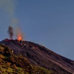
1) VOLCANOLOGICAL OBSERVATIONS: During this period, normal Strombolian-type explosive activity was observed with spattering activity in the North Crater area. The total hourly frequency fluctuated between medium-low (9 events/h) and medium (11 events/h). The intensity of the explosions was mainly low in the northern area of the crater and medium to high in the central-southern area of the crater.
2) SEISMOLOGY: The seismological parameters monitored do not show any significant variations, with the exception of the appearance of the lava overflow and the increase in the amplitude of the tremor of 11/16.
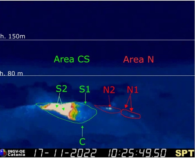
The crater terrace seen from the thermal camera placed on the Pizzo sopra la Fossa with the delimitation of the crater zones: Center-South Zone and North Zone (area N, area C-S respectively). Symbols and arrows indicate the names and locations of active vents, the area above the crater terrace is divided into three height ranges relative to the intensity of the explosions.
3) SOIL DEFORMATIONS: During the period considered, the island’s soil deformation monitoring networks did not record any significant variations.
4) GEOCHEMISTRY: SO2 flux at an average and increasing level.
CO2 fluxes in the crater area remain at medium-high values.
Stromboli’s weekly average CO2/SO2 ratio shows average values of 9.4.
There are no updates on the isotope ratio of helium in groundwater.
5) SATELLITE OBSERVATIONS: Thermal activity observed by satellite in the summit area was weak to moderate.
VOLCANOLOGICAL OBSERVATIONS
During the observation period, the eruptive activity of Stromboli was characterized by the analysis of the images recorded by the INGV-OE surveillance cameras at 190 m (SCT-SCV), Punta dei Corvi and Pizzo, while the camera at 400 m following problems in the acquisition of video signals caused by damage to the fiber optic connection between Punta Labronzo and AOC due to the bad weather that hit the island on August 12, 2022, is currently not not available. The explosive activity was mainly produced by 3 (three) eruptive vents located in the North zone of the crater and by 2 (two) vents located in the Center-South zone. All vents are placed inside the depression that occupies the crater terrace.
Due to the unfavorable weather conditions on November 18-19 and 20, the visibility of the crater terrace was insufficient for a correct description of the eruptive activity. In addition, from 10:36 UTC on November 20, image acquisition was interrupted due to a technical failure.
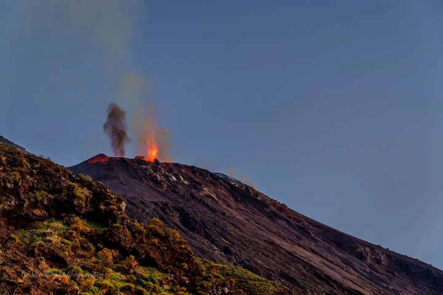
Observations of explosive activity captured by surveillance cameras
Sector N1, with two emission points, located in the northern zone of the crater, produced explosions of medium to low intensity (less than 120 m in height) emitting coarse materials (bombs and lapilli). Sector N2, with two emission points, showed mainly low intensity explosive activity emitting coarse materials and discontinuous low intensity projection activity. The average frequency of explosions varied from 3 to 6 events/h.
In the Center-South zone, no explosive activity was observed in sectors S1 and C, while in sector S2, with two emission points, explosive activity of variable average intensity (less than 150 m height) to high (more than 250 m high) was observed, emitting coarse materials mixed with fine materials (ash). The average frequency of explosions is almost constant between 5 and 6 events/h.
Source : INGV.
Photos : INGV , Stromboli stati d’animo.
Italy , Campi Flegrei :
WEEKLY BULLETIN, from November 14, 2022 to November 20, 2022. (issue date 22 November 2022)
ACTIVITY STATUS SUMMARY:
1) SEISMOLOGY: In the week of November 14 to 20, 2022, 149 low-energy earthquakes were recorded in the Campi Flegrei area (Mdmax= 1.2+/-0.3).
2) DEFORMATIONS: The average value of the uplift velocity in the maximum deformation zone since mid-June 2022 is about 7±1 mm/month. The uplift recorded at the RITE GPS station is about 94.5 cm since January 2011.
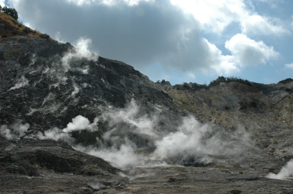
3) GEOCHEMISTRY: The soil CO2 fluxes measured last week did not show any significant variations. The temperature sensor installed in a fumarole emission 5 meters from the main Pisciarelli fumarole showed an average value of around 87°C, lower than the condensation temperature of the fumarole fluid (~95°C).
GROUND DEFORMATIONS
GNSS. Since mid-June 2022, the average uplift velocity value in the maximum deformation zone is about 7±1 mm/month.
In recent weeks, in conjunction with greater seismic activity in the area, there has been an increase in the rate of deformation. This variation, the real trend of which can be assessed with data for the coming weeks, affects both the vertical (RITE station height variations) and planimetric (baseline length variations) components.
The uplift recorded at the RITE GNSS station is about 94.5 cm since January 2011, including about 10.5 cm since January 2022.
GEOCHEMISTRY
The values of the CO2 flux from the ground recorded continuously by the FLXOV8 station in the Pisciarelli area (north-eastern outer slope of Solfatara), highlight the persistence of the multi-annual trends already identified previously (see Monthly Bulletins). Soil CO2 fluxes measured last week showed no significant changes from previous periods.
The temperature sensor installed in the main fumarole is no longer functional and will have to be replaced, but due to the macroscopic variations of the fumarole area and the stability of the ground, in compliance with the precautionary principle and in order to operate safely, maintenance activities in the area are currently suspended.
Source : INGV.
Read the article : https://www.ov.ingv.it/index.php/monitoraggio-e-infrastrutture/bollettini-tutti/boll-sett-flegrei/anno-2022/1183-bollettino-flegrei-2022-11-22/file
Photo : Stanley-goodspeed
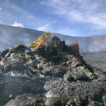
Colombia , Purace / Los Coconucos Volcanic Range:
Weekly bulletin of activity of the Puracé volcano – Los Coconucos volcanic range.
The activity level of the volcano continues at the yellow Activity Level or (III): changes in the behavior of volcanic activity.
From the analysis and evaluation of the information obtained through the monitoring network of the Puracé volcano – Los Coconucos volcanic chain, during the week of November 15 to 21, 2022, the COLOMBIAN GEOLOGICAL SERVICE – Volcanological and Seismological Observatory of Popayán reports that:
With regard to the seismic activity recorded, there were no notable variations in terms of the number of events and the energy released. During the week, 600 seismic events were recorded, of which 83 were associated with rock fracturing processes (VT type) and 517 with fluid dynamics in volcanic conduits.
The geodetic network of GNSS (Global Navigation Satellite System) stations for monitoring ground deformation continues to record a process associated with inflation.
By monitoring the surface activity with the images obtained during the week through the web cameras Mina, Lavas Rojas, Cerro Sombrero and Curiquinga, it has been highlighted
degassing of the volcanic system, with a white column oriented preferentially to the northwest.
Regarding the monitoring of volcanic gases, sulfur dioxide (SO2) measurements continue to show changes with a maximum flow of 569 t / day for the week evaluated. The other instruments for measuring the concentration of carbon dioxide (CO2) and radon gas (222Rn) in the recorded a considerable increase for the period evaluated in the context of this active volcanic system.
Sensors monitoring electromagnetic fields and infrasonic waves did not record variations associated with changes in volcanic activity.
It is concluded from the above that variations in volcanic activity continue to be recorded, consistent with the behavior expected in a level of activity III (yellow level), which could evolve towards states of greater activity.
Source et photo : SGC
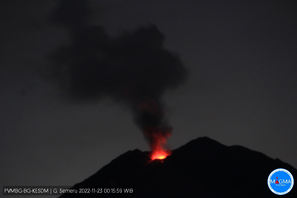
Indonesia , Semeru :
Mount Semeru erupted on Wednesday November 23, 2022 at 00:02 WIB with an ash column height observed at ± 700 m above the summit (± 4376 m above sea level). The ash column was observed to be gray with a thick intensity, oriented to the Southeast and South. This eruption was recorded on a seismograph with a maximum amplitude of 23 mm and a duration of 97 seconds.
SEISMICITY OBSERVATION
26 earthquakes of eruptions/explosions with an amplitude of 10 to 23 mm and a duration of 61 to 104 seconds.
Recommendation
1. Do not carry out any activity in the Southeast sector along Besuk Kobokan, up to 13 km from the summit (the center of the eruption). Outside of this distance, the community does not carry out activities within 500 meters of the bank (river edge) along Besuk Kobokan as it has the potential to be affected by cloud expansion. hot and lava flows up to a distance of 17 km from the summit.
2. Do not move within a radius of 5 km around the crater/summit of Mount Semeru because this area is subject to the danger of (incandescent) projections.
3. Be aware of the potential for hot cloud descent (APG), lava avalanche along the rivers/valleys that disgorge from the summit of Mount Semeru, especially along Besuk Kobokan, Besuk Bang, Besuk Kembar and Besuk Sat as well as potential lahars in the rivers which are tributaries of the Besuk Kobokan.
Source et photo : Magma Indonésie .
Ecuador , Cotopaxi :
Summary
On the night of October 21, a low frequency tremor signal associated with an emission of gas and ash was recorded, which produced a moderate fall of this material on the northern flank of the volcano, including the José Rivas Refuge. Since then, gas emission has been almost continuous and clearly visible, with columns reaching up to 2 km above crater level. The parameters monitored by the IG-EPN show that the Cotopaxi still has a low internal activity, marked by a seismicity slightly higher than the reference level since 2015. The GPS stations present a possible deformation whose amplitude in some stations barely exceeds atmospheric noise levels.
Regarding volcanic gases, the values remain above the reference level after the 2015 eruption and have a magmatic origin. Crater temperature measurements show values similar to those after 2015. The uncertainty about the evolution of this activity is very high due to the lack of clear warning signs for events similar to the one that occurred on 21st of October.
Seismicity analysis
The current rates of seismicity of the Cotopaxi volcano have been characterized on the basis of the trends present during the last two years and those observed in the month following the emission of ash on October 21. For this, we extract events of magnitudes > 1 located by our network between December 2020 and the current date. It is observed that in terms of location, most of the seismicity occurs directly under the summit of the volcano. However, there is also a group of earthquakes characterized as probable aftershocks of the Machachi earthquake of October 27, 2020 (06:59 TL). This group of earthquakes is located in the area between the Pasochoa, Rumiñahui, and Sincholahua volcanoes, and showed increased rates in October 2021.
Deformation
For the analysis of the deformations, the processing of GPS stations located on the flanks of the volcano, inclinometers and satellite images processed with the InSAR method were carried out. InSAR processing of Sentinel images shows no pattern of inflation on the volcano’s flanks.
Thermal monitoring
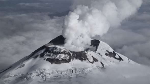
Thanks to the thermal monitoring flyby of November 20, it was verified that the fumarolic fields maintain values of maximum apparent temperature (TMA) similar to those of previous years (post 2015) and to the flyby of October 27, 2022. These correspond in Yanasacha, Fumarolas Flanco Este, Fumarolas Flanco Sur, Fumarolas Flanco Oeste, with respective values of 12, 22, 37 and 10°C. In some areas, low intensity active fumaroles were observed. In addition, it was found that the immediate interior walls of the crater present continuous fumarolic fields with values varying between 10 and 22°C. On the other hand, due to the strong emission of gas, it was not possible to reliably estimate the temperature values of the base of the crater in either of the two recent flybys. Regarding the morphology, between the gas emission, it was possible to show a regular horizontal morphology, which could represent the base of the crater, which was already observed in March 2018. The maximum apparent temperatures recorded for this area reach 98° C, however, are underestimated values due to the abundant presence of gas.

Thermal images from November 20, 2022 of the Cotopaxi volcano’s fumarolic fields present outside and inside the crater rim.
Data interpretation
After the small eruptive episode of October 21 (VEI less than 1), the joint analysis of the various monitoring data shows that the current activity of Cotopaxi is caused by the presence of magma in the volcanic conduit. There is no evidence of new magma entering the system. Despite the fact that the events of the past month define an upward trend for Cotopaxi’s surface activity, its internal activity does not show any significant change. Seismicity continues to be dominated by small LP-type earthquakes and for now there is no detectable deformation on the flanks of the volcano. The gases measured indicate the degassing of a superficial magma which did not receive a supply of new gas-rich magma. In this sense, it is important to maintain the monitoring of all these parameters in order to identify in time the rise of new magma which could generate greater surface activity, in particular explosions and ash emissions.
Source : IGEPN.
Read the full article : https://informes.igepn.edu.ec/igepn-registro-web/pages/public/InformeGenerado.jsf?directorio=28668&fbclid=IwAR1-0jzRHhf1HBdPdsm2mchYNSdRzf5L_XHvcbx6uKolPXSdsizNZNL0qRw


No comment yet, add your voice below!