
October 16 , 2022.
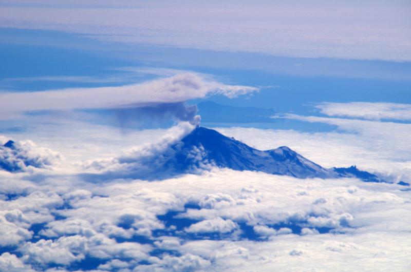
Italy , Stromboli :
Press release on the activity of STROMBOLI, October 15, 2022, 18:51 (16:51 UTC).
The National Institute of Geophysics and Volcanology, Osservatorio Etneo, announces that from the analysis of images from surveillance cameras and field observations, it is clear that the flow along the Sciara del Fuoco does not is more energized and, therefore, cools down. In the North Crater area, spatter activity at vent N2 persists as well as ordinary Strombolian activity at vent N1 with sporadic explosions.

During the observation period, no activity was detected in the area of the Center-South crater.
The average amplitude of the volcanic tremor continues to record small fluctuations in its values with a general trend which, since the early hours of today, shows an upward trend. At present, the amplitude of the tremor is mainly confined to the medium-high level.
Data from deformation monitoring networks on the island show no significant changes since the last release.
Further updates will be communicated soon.
Source : INGV.
Photo ( For pleasure) : Stromboli Stati d’animo .
Iceland , Grímsvötn :
Minor jökulhlaup in Grímsvötn
Aviation color code raised from green to yellow. , 13.10.2022
The glacial flood from Grímsvötn is still ongoing and maximum discharge of about 500 m3/s from Grímsvötn sub-glacial lake is expected to be reached later today or tonight. The ice-shelf on top of the sub-glacial lake has now subsided approximately 12 m since 5th of October. Since yesterday morning signals of floodwater have been detected in Gígjukvísl river by water level measurements and on images from a web camera.
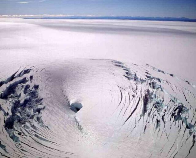
The discharge in Gígjukvísl river is expected to continue to increase and reach maximum discharge a day later than maximum discharge from Grímsvötn, which is approximately the time it takes the flood water to flow from Grímsvötn to Skeiðarársandur . The maximum discharge in Gígjukvísl expected in this flood is similar to maximum discharge during peak summer melt on the glacier and will therefore not affect any infrastructure such as roads or bridges.
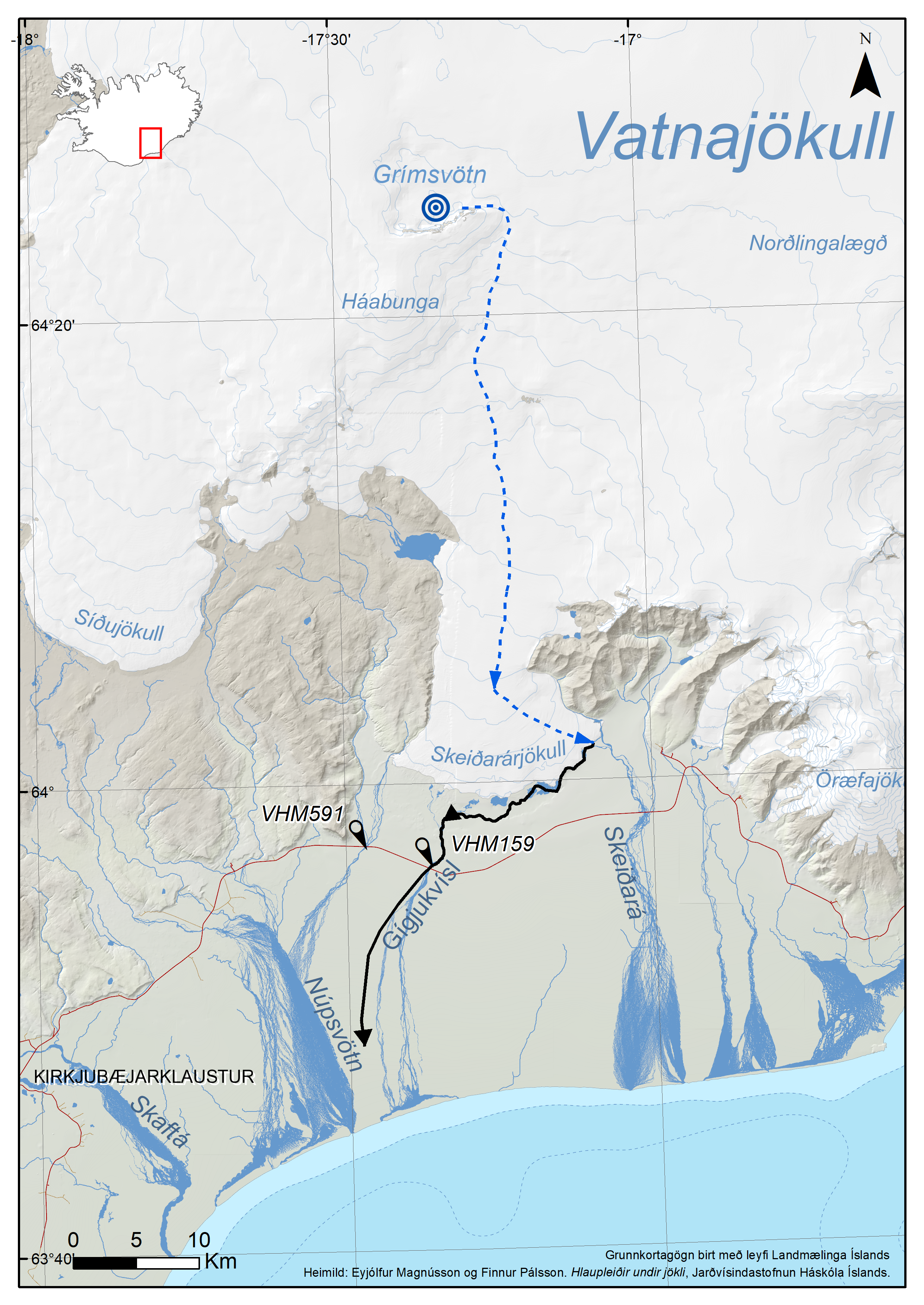
The map shows approximately the floods pathway underneath the glacier. It is assumed that the maximum discharge in Gígjukvísl river will be lower than the maximum discharge from Grímsvötn because it will be affected by the lagoons in front Skeiðarárjökull glacier. The flood pathway outside the glacier is marked by the black line and VHM159 is the water level station at Gígjukvísl. (Map by Bogi Brynjar Björnsson)
No significant changes have been observed in seismic activity at Grímsvötn volcano during this flood event. The Icelandic Met Office together with the scientists at IES continue to monitor Grímsvötn and will publish information depending on the development of the scenario.
Source : Vedur is.
Photos : GVP , Bogi Brynjar Björnsson
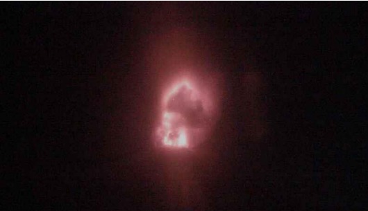
Russia / Kuril Islands , Chikurachki :
VOLCANO OBSERVATORY NOTICE FOR AVIATION (VONA)
Issued: October 16 , 2022
Volcano: Chikurachki (CAVW #290360)
Current aviation colour code: ORANGE
Previous aviation colour code: orange
Source: KVERT
Notice Number: 2022-139
Volcano Location: N 50 deg 19 min E 155 deg 27 min
Area: Northern Kuriles, Russia
Summit Elevation: 1816 m (5956.48 ft)
Volcanic Activity Summary:
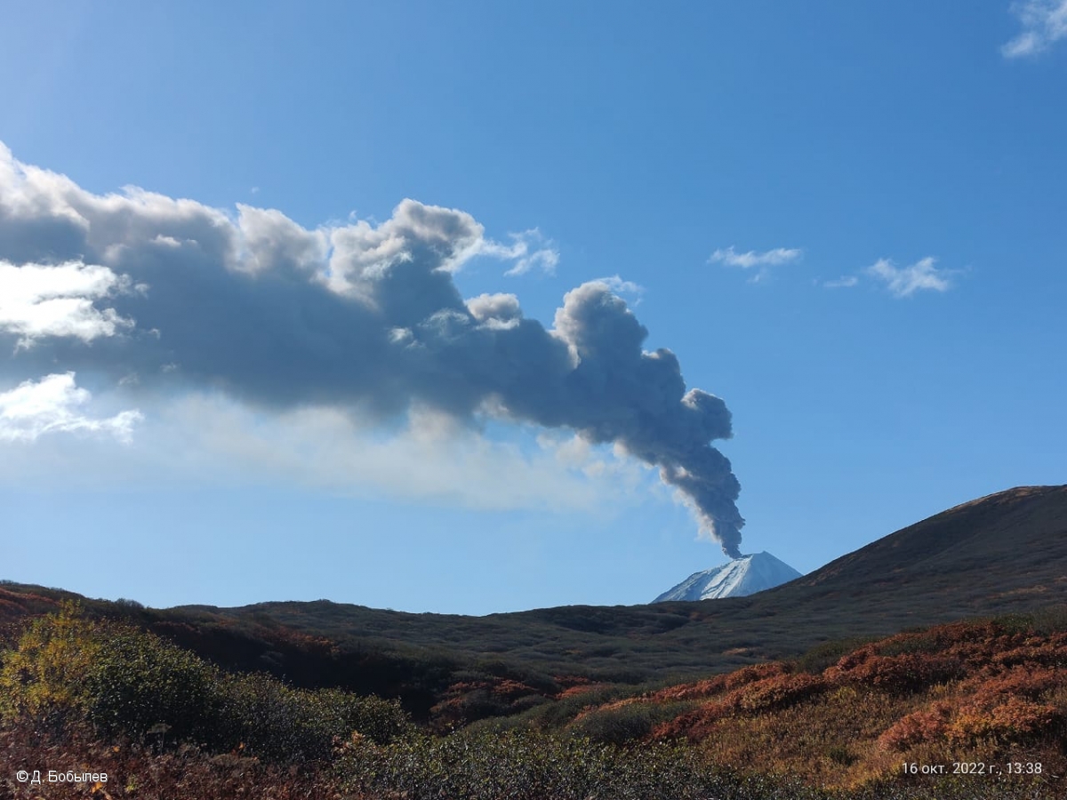
An eruptive activity of the volcano continues. Satellite data by KVERT showed an ash plume extended about 523 km to the east-south-east of the volcano.
An activity of the volcano continues. Ash explosions up to 6 km (19,700 ft) a.s.l. could occur at any time. Ongoing activity could affect low-flying aircraft.
Volcanic cloud height:
3000-3500 m (9840-11480 ft) AMSL Time and method of ash plume/cloud height determination: 20221016/0420Z – Himawari-8 14m15
Other volcanic cloud information:
Distance of ash plume/cloud of the volcano: 523 km (325 mi)
Direction of drift of ash plume/cloud of the volcano: ESE / azimuth 109 deg
Time and method of ash plume/cloud determination: 20221016/0420Z – Himawari-8 14m15
Source : Kvert.
Photo :D. Bobylev
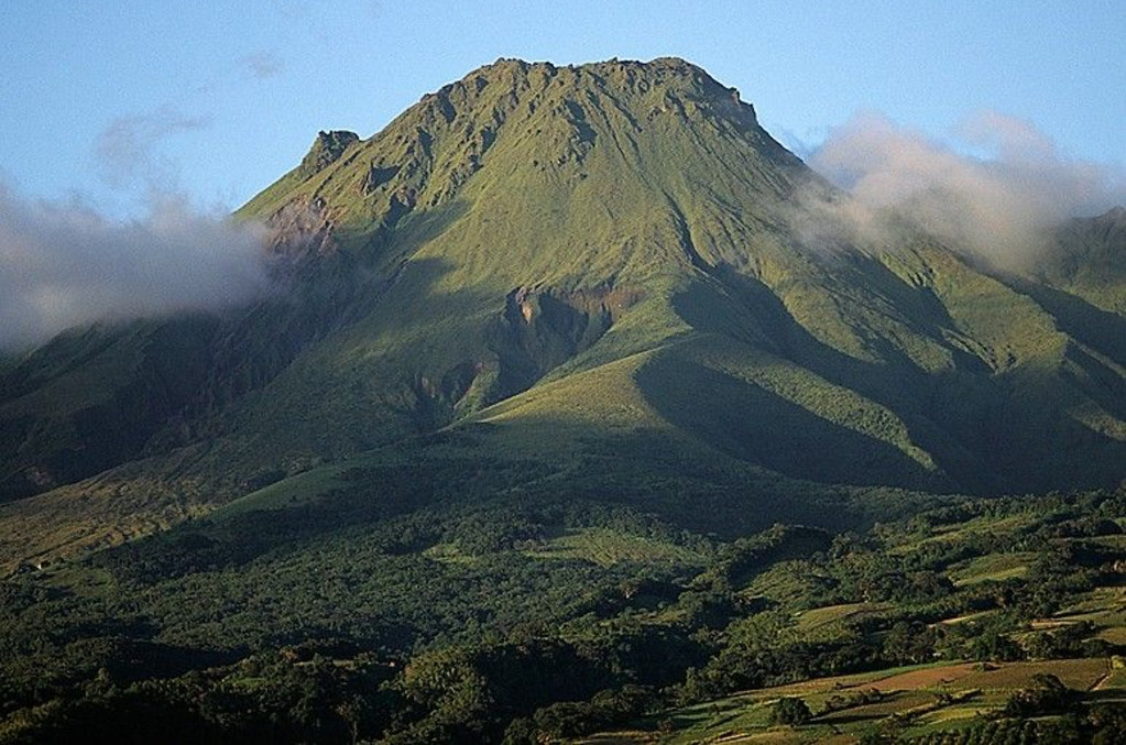
La Martinique , Mount Pelée :
Weekly report on the activity of Mount Pelée for the period from October 07, 2022 to October 14, 2022.
Between October 07, 2022 at 4 p.m. (UTC) and October 14, 2022 at 4 p.m. (UTC), the OVSM recorded at least 9 volcano-tectonic earthquakes. Eight of these low-energy earthquakes (magnitudes less than 0.3) could not be located. They are identical to those of the well-known families on Pelee which are located inside the volcanic edifice around 0.4 km deep above sea level or approximately 1 km deep below the summit. A volcano-tectonic earthquake of magnitude 1.2 could be located in the same area as the previous ones. This superficial volcano-tectonic seismicity is associated with the formation of micro-fractures in the volcanic edifice.
None of these earthquakes was felt by the population.
During volcanic reactivation phases of volcanoes similar to Mount Pelee, periods of higher seismic activity often alternate with phases of lower seismicity. Since the reactivation of the hydrothermal-magmatic system (end of 2018), several periods of zero or weak seismicity have been recorded by the OVSM, for example May 2019 (5 earthquakes), October 2019 (3 earthquakes), August 2020 (1 earthquake) , and only 8 earthquakes between June 24 and August 8, 2022 (period of 2 months).
The areas of degraded vegetation located between Morne Plumé and the Chaude River were observed during a helicopter flight carried out on February 9 and May 5, with the support of Dragon 972, and confirmed by analysis of satellite and drone images. (overview of May 11) and satellite analysis (June 2022). A new area of degraded vegetation, located just north of the Chaude River, was observed from August 26th.
The alert level remains YELLOW: vigilance.
Source : OVSM-IPGP.
Photo : Photopoesie.
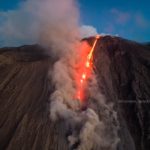
Alaska , Pavlof :
55°25’2″ N 161°53’37 » W,
Summit Elevation 8261 ft (2518 m)
Current Volcano Alert Level: WATCH
Current Aviation Color Code: ORANGE
Pavlof Volcano continues to erupt from the active vent just below the summit on its east flank. Small ash plumes and glowing ejected rock fragments were observed in clear day and night webcam images. Clear satellite images showed an area of high surface temperatures at the vent, but no flow deposits down the flank. Seismic and infrasound data recorded numerous small explosions on October 7, 9, 11, 12, and 13 and nearly continuous seismic tremor throughout the week.
Periods of lava spatter and fountaining from the vent on the volcano’s upper east flank have been occurring since mid-November 2021. This activity has built a small cone and sent lava flows down the flank that melt the snow and ice and produce variable amounts of meltwater. The meltwater typically incorporates loose debris on the flank of the volcano and forms thin (less than 2 m thick) lahars. The lahar deposits extend down the east-southeast flank for several kilometers, not quite to the base of the volcano.
Previous eruptions of Pavlof indicate that the level of unrest can change quickly and the progression to more significant eruptive activity can occur with little or no warning.
Pavlof is monitored by local seismic and infrasound sensors, satellite data, web cameras, and regional infrasound and lightning networks.
Source : AVO
Photo : Izbekov, Pavel
Chile , Nevados de Chillan :
Special Report on Volcanic Activity (REAV), De Nuble region, Nevados de Chillan volcanic complex, October 15, 2022, 9:30 p.m. local time (mainland Chile).
The National Service of Geology and Mines of Chile (Sernageomin) publishes the following PRELIMINARY information, obtained through the monitoring equipment of the National Volcanic Monitoring Network (RNVV), processed and analyzed at the Volcanological Observatory of the Southern Andes ( Ovdas):
Saturday October 15, 2022, at 9:08 p.m. local time (00.08 UTC October 16, 2022), the monitoring stations installed near the Nevados de Chillan volcanic complex recorded an earthquake associated with fluid dynamics (long period type), at the inside the volcanic system.
The characteristics of earthquakes after their analysis are as follows:
ORIGINAL TIME: 9:08 p.m. local time (00.08 UTC)
REDUCED DISPLACEMENT: 570 cm2
ACOUSTIC SIGAL: 64 Pascals reduced to 1 km
The characteristics of surface activity are as follows:
it is not possible to display the maximum height of the eruptive column, however, the incandescent material reached a maximum height of 800 meters above the active crater.
COMMENTS:
An incandescence was observed with a height of 800 m above the crater, and expulsion of incandescent materials in a preferential direction towards the northeast, over an approximate distance of 700 m.
The volcanic technical alert remains at the Yellow level.
Sources et photo: Sernageomin.


No comment yet, add your voice below!