
October 21 , 2021.
Japan : Asosan
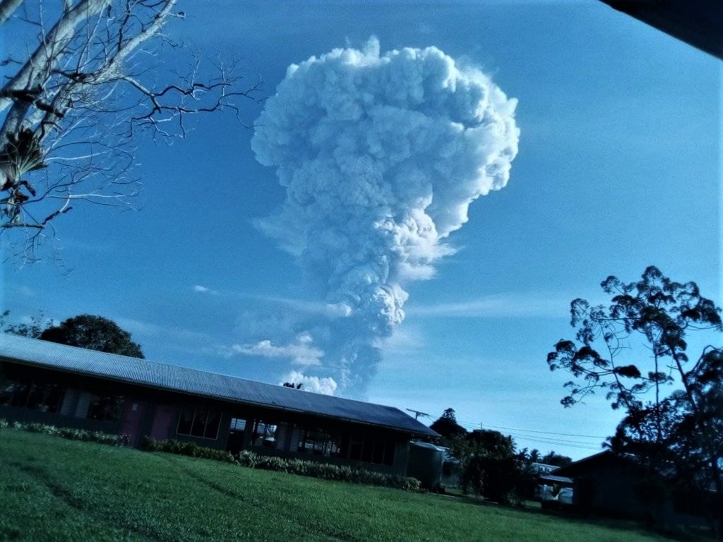
According to JMA the number of volcanic tremor signals at Asosan began on 12 October. Tremor amplitude began increasing at 1530 on 13 October, prompting JMA to raise the Alert Level to 2 (on a scale of 1-5) almost two hours later. White plumes rose 1.4 km above Nakadake Crater. An eruption was detected at 0443 on 14 October; weather clouds prevented visual confirmation of an eruption plume, though ejected incandescent material was visible in thermal camera images. During a field visit to the volcano later that day, scientists confirmed ashfall in several areas, including parts of Takamori Town (Kumamoto Prefecture), Taketa City (Oita Prefecture), and Takachiho Town (Miyazaki Prefecture).
Small eruptive events occurred at 1057 and 1325 on 15 October. Volcanic tremor amplitude increased at 1400 on 18 October. During an overflight scientists observed ash deposits extending SE from Nakadake Crater. Volcanic tremor amplitude continued to fluctuate at high levels on 19 October. At 1143 on 20 October a notable eruption ejected blocks 900 m S and produced an ash plume that rose 3.5 km above the crater rim and drifted E. Pyroclastic flows descended 1.3 km W. The Alert Level was raised to 3 at 1148 and warned the public to stay 2 km away from Nakadake Crater.
Sources : Japan Meteorological Agency (JMA) , GVP .
Video : Nakajima Takeshi
Papua New Guinea , Manam :
RVO reported that sporadic small ash emissions from Manam’s Southern Crater were observed starting at the end of September. Nighttime incandescence began on 8 October and incandescent material was occasionally ejected from the crater. The activity was characterized as moderately Strombolian with incandescent material rolling down SW Valley, visibly appearing as short lava flows. The Darwin VAAC noted that on 18 October an ash plume rose to 2.4 km (8,000 ft) a.s.l. and drifted NW. A thermal anomaly was visible in satellite images.
RVO stated that at around 0800 on 20 October a large explosion at Southern Crater produced ash plumes that rose at least 1 km above the summit and drifted N and NW. According to the Darwin VAAC ash plumes rose as high as 15.2 km (50,000 ft) a.s.l. between 0840-0950, expanded radially, and then drifted E. Lower-level plumes rose 4.6-5.5 km (15,000-18,000 ft) a.s.l. and drifted NW. Later that day a collapse of newly erupted material, as well deposits from the previous few weeks, produced a debris flow that originated at the head of the valley and descended the SW Valley.
Sources : Rabaul Volcano Observatory (RVO), Darwin Volcanic Ash Advisory Centre (VAAC) , GVP.
Photo : Mangi Tais Agamguar via Sherine France.
Italy , Vulcano :
Weekly Bulletin, from October 12, 2021 to October 19, 2021
SUMMARY STATEMENT OF ACTIVITY
In view of the monitoring data, it should be noted that:
1) GEOCHEMISTRY:
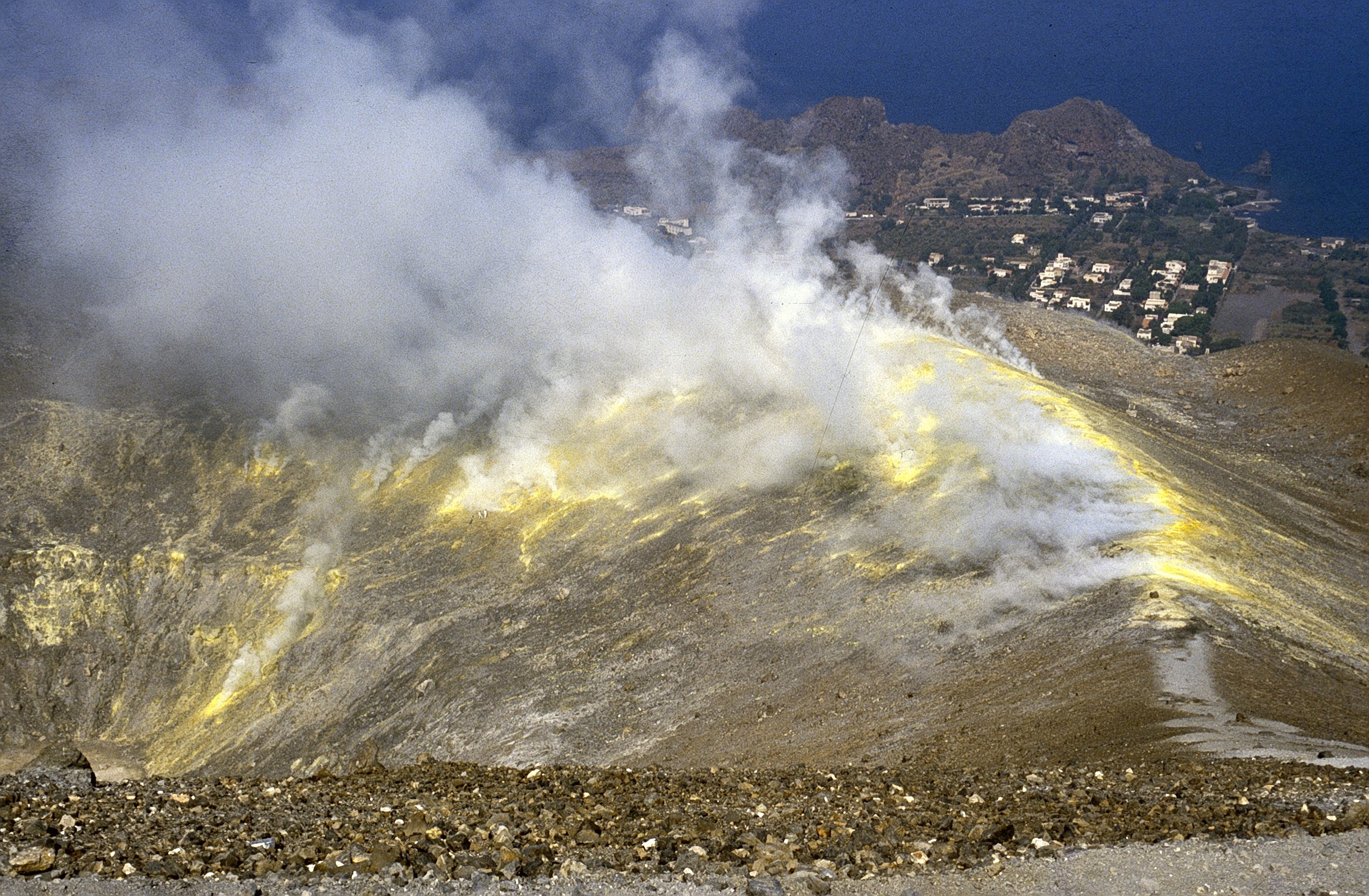
Temperature of the fumaroles of the crater: slightly increasing in the internal slope of La Fossa while at the edge there are no definite signals due to the frequent rains which have occurred in recent days which disturb the thermal state;
CO2 flux in the crater area: slightly lower but with high degassing levels;
SO2 flow in the crater area: at a high level of geochemical degassing of fumarolic gases: the last sample of October 12, 2021 indicates very high magmatic gas contents in the fumaroles of the crater;
CO2 flux at the base of the La Fossa cone and in the area of Vulcano Porto: constantly high in the area of Grotta dei Palizzi and increasing on the sites of Camping Sicilia and at the base of the Old Forge (site of Rimessa); in the other sites no significant variation is observed;
Geochemistry of thermal aquifers: the upward trend continues, although slightly down, in the water temperature on the Sicilia Campsite site while the conductivity values are down slightly; no significant changes on the other monitored sites;
2) GEOPHYSICS:
Local seismicity: decrease in the rate of occurrence of low frequency events (<1Hz). Regional seismicity: no fracturing event during the week considered.
Distortions – GNSS: GNSS data shows that the strong variations, which started in mid-September, appear to have stopped last week.
Deformations – Clinometry: in recent days the inclinometric network has shown an attenuation of the variations initiated on September 13.
Gravimetry: two continuous gravity stations were installed between October 12 and 13, 2021. The signals acquired and some variations recorded are displayed.
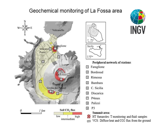
Figure 3.1 – Location of stations for measuring soil CO2 flow, physico-chemical parameters in thermal aquifers, emission temperatures, as indicated in the legend. The “HT fumaroles” sector includes the main high temperature fumaroles (F0, F11, F5, F5AT and FA) and thermal monitoring sites (F5; F5AT1; F5AT2; Internal slope).
Fumarole temperatures and heat flux in the crater area:
The average of the measurements recorded last week (11-18 October) for the T2 sensor placed at the edge of the La Fossa crater was 339 ° C (full range 119 – 366 ° C); in addition, the T3 signal, also placed at the edge of the main fumarolic field, is extremely disturbed and with relatively lower T (m = 127 ° C; range 41 – 306 ° C). On the inner face of the crater we register a slight increase, with T increasing by 0.4 ° C from the low of 108 ° C (October 8) to the current value of 111 ° C (October 17) and the signal seems undisturbed.
Source : INGV.
Photo : Boris Behncke
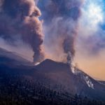
Spain / La Palma , Cumbre Vieja :
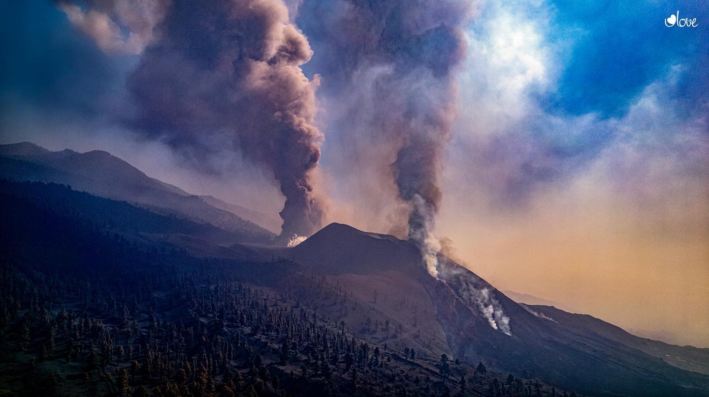
The most recent eruptive mouth, which opened last Friday about 300 meters south of the main cone of the Cumbre Vieja volcano in La Palma, began to emit pyroclasts, in addition to ash, reports the National Geographic Institute ( IGN). At the moment, there is no trace of flow coming out of this new eruptive mouth. A 4.8 magnitude earthquake rocked the island on Tuesday night, the strongest earthquake since the volcano erupted. The earthquake occurred at 9:48 p.m. at a depth of 39 kilometers. Since then, La Palma has suffered more than 20 earthquakes, at least 18 since midnight. Late yesterday, the lava flows threatened to cross the center of the district of La Laguna, in Los Llanos de Aridane, and another was about 100 meters from the sea.
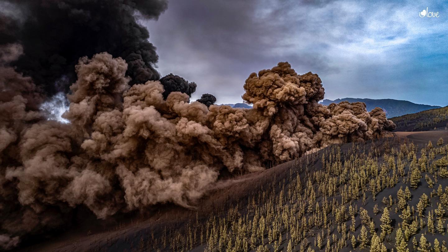
October 20, 2021 09:00 UTC. Eruptive activity continues on La Palma
Since the last declaration, 71 earthquakes have been located in the area affected by the volcanic reactivation of Cumbre Vieja, 7 of these earthquakes were felt by the population, the maximum intensity being in the epicentral zone V (EMS98) , with the earthquake that occurred at 21:48 UTC on the 19th, with a magnitude of 4.8 mbLg at a depth of 39 km. This earthquake was widely felt throughout the island of La Palma and by some populations of the islands of La Gomera and Tenerife with intensities II and II-III (EMS98). It is the largest earthquake of the entire seismic series.
During the period considered, a total of 5 earthquakes were located at depths of about 30 km, the rest of the hypocenters of the period are located at a shallower depth, about 12 km.
The volcanic tremor signal maintains a high average amplitude, with intensifying pulses.
The height of the dispersion cloud measured at 08:00 UTC is estimated at 3500 m.
The network of permanent GNSS stations on the island, as yesterday, does not show a clear tendency to deformation of the stations closest to the eruptive centers, on the other hand, in the more distant stations, a slight deflation is observed, perhaps linked to deep seismicity.
In the early hours of Wednesday evening, the Pevolca ordered the evacuation of the neighborhoods of Las Martelas, in the municipality of Los Llanos de Aridane; and Marina Alta, Marina Baja, La Condesa and Cuesta Zapata in the municipality of Tazacorte, due to the advancing Northwest lava flow. People residing in this area « must leave their homes, with their belongings and their pets ». Those who cannot recover their goods will be allowed in the following days, gradually and accompanied, to return to their homes, provided that the security conditions allow it. The evacuation order went into effect at 8:30 p.m. and affects between 40 and 50 homes.
Source : El Pais , IGN es .
Photos : I Love The World.
Italy , Stromboli :
Weekly Bulletin, from October 12, 2021 to October 17, 2021 (issue date October 19, 2021).
SUMMARY STATEMENT OF ACTIVITY.
In view of the monitoring data, it is highlighted:
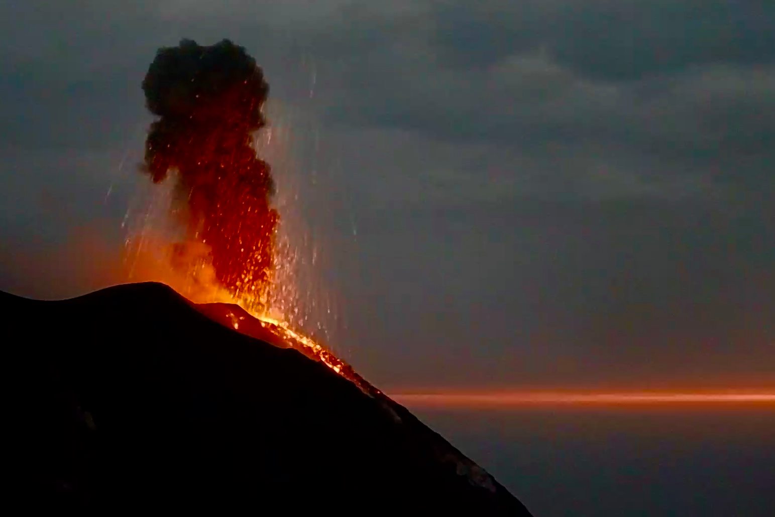
1) VOLCANOLOGICAL OBSERVATIONS: During this period a normal explosive activity of strombolian type was observed. The total hourly frequency of explosions fluctuated between medium-low and medium-high values (8-16 events / h). The intensity of the explosions was low in the North crater area and variable from low to high in the Center-South area.
2) SEISMOLOGY: The seismological parameters monitored do not show significant variations.
3) DEFORMATIONS: The island’s soil deformation monitoring networks did not show any significant changes to report for the period under review.
4) GEOCHEMISTRY: The flow of SO2 at a medium-low level
The flow of CO2 emitted by the ground at Pizzo Sopra la Fossa is at medium-high levels.
The updated C / S ratio values were at medium-low levels (C / S = 4.41).
The value of the isotopic ratio of helium dissolved in the thermal aquifer of Stromboli (from October 05) is at high values.
5) SATELLITE OBSERVATIONS: The thermal activity in the summit area is at a low level.
VOLCANOLOGICAL REMARKS:
Description of eruptive activity by surveillance cameras:
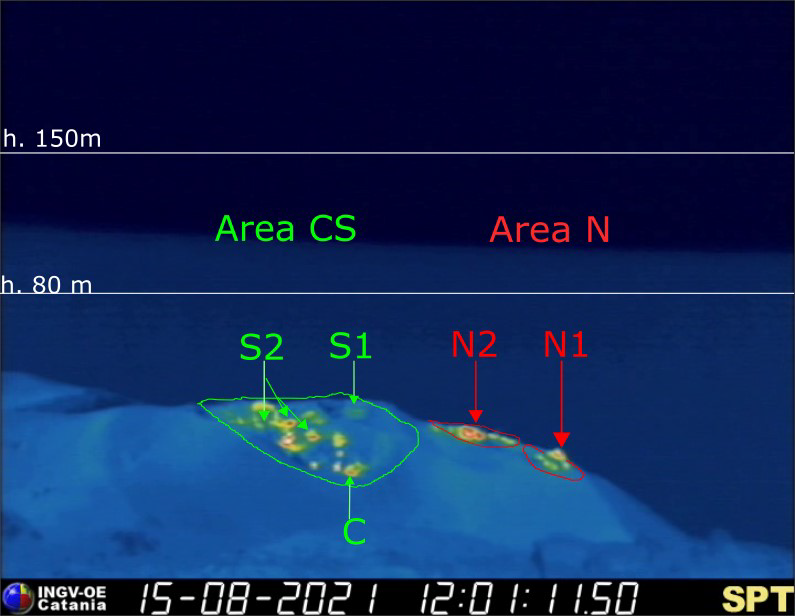
The N1 crater located in the North zone, with three emission points, produced explosions of a generally low intensity (less than 80 m in height) emitting fine materials (ash) mixed with lapilli and bombs. Vent N2 showed low intensity explosive activity (less than 80 m in height) emitting fine material mixed with coarse material. The average frequency of explosions varied from 2 to 7 events / h.
In the Center-South zone, sector S1 sporadically showed low-intensity explosive activity emitting fine materials, while the three vents located in sector S2 produced explosions, even simultaneously, of varying intensity, from low to high ( the products of some explosions exceeded 150 m in height) emitting coarse materials. Sector C showed no significant activity. The frequency of the explosions varied from 5 to 9 events / h.
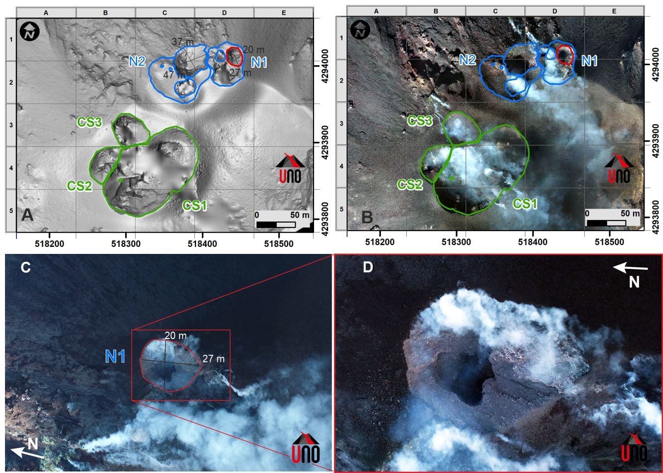
Fig. 3.3 – A) Numerical model of the terrain and B) orthomosaic of the area of the crater treated following the overflight on 12 October. N = area of the north crater CS = area of the crater CS; C) Image of the N1 crater area; D) detail of the explosive mouth.
Morphological observations following the inspections of October 9 and 12, 2021:
During the inspections carried out on October 9 and 12 as part of the activities of the UN Departmental Project, it was possible to document the morphological changes that occurred in the crater zone following the explosion of October 6.
In particular, thanks to an overflight with drones, the digital model of the terrain and an ortho-mosaic of the crater area were developed (Figure 3.3 A and B). Despite the cloud cover, the area of the N1 crater was photographed where we can see the explosive vent and a significant presence of light and dark ballistic projections also of metric dimensions due to the activity of October 06. (Figure 3.3 C and D). It should also be noted the presence of a depression of considerable size (approximately 47 x 37 m) located between zones N1 and N2.
Other investigations are underway for a quantitative assessment of morphological variations in the crater area.
Source : INGV.
Photos : INGV , Webcam.


No comment yet, add your voice below!