
February 16 , 2021 .
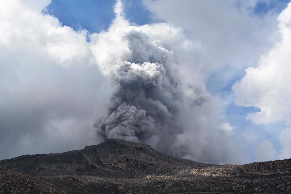
Italy / Sicily , Etna :
COMMUNICATION ON THE ACTIVITY OF ETNA [UPDATE n. 126]
The National Institute of Geophysics and Volcanology, Osservatorio Etneo announces that from the early hours of today February 15, 2021, a gradual intensification of explosive activity at the level of the Southeast crater is observed. While activity is continuous at the eastern mouths of the same crater, sporadic and sometimes violent explosions are also observed at the « mouth of the saddle ». Intra-crater explosive activity also continues in the craters of Bocca Nuova, Voragine and Northeast.
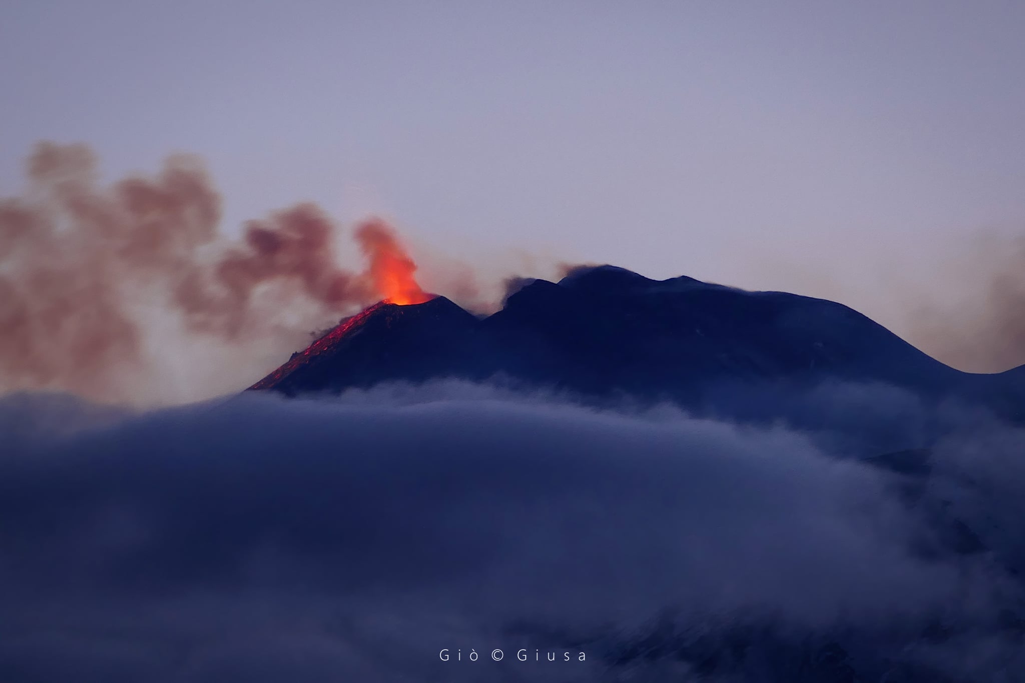
As for the average amplitude of the volcanic tremor, it had already shown an upward trend from the early hours of this morning. From around 4 p.m. GMT a more significant increase was recorded: the amplitude reached high values and they remain so until the current state. The source of the tremor is located under the South-East crater, at a depth of about 2900 m.
The infrasonic activity appears to be high, both for the frequency of occurrence of infrasonic transients and for their amplitude.
The distortion data from the GPS and inclinometric networks do not show any significant changes.
COMMUNICATION ON THE ACTIVITY OF ETNA [UPDATE n. 127]
The National Institute of Geophysics and Volcanology, Osservatorio Etneo, announces that from 8:00 p.m. GMT a gradual decrease in explosive activity is observed at the East vents of the Southeast crater, where modest Strombolian activity persists.
Activity at the other summit craters does not show significant changes.
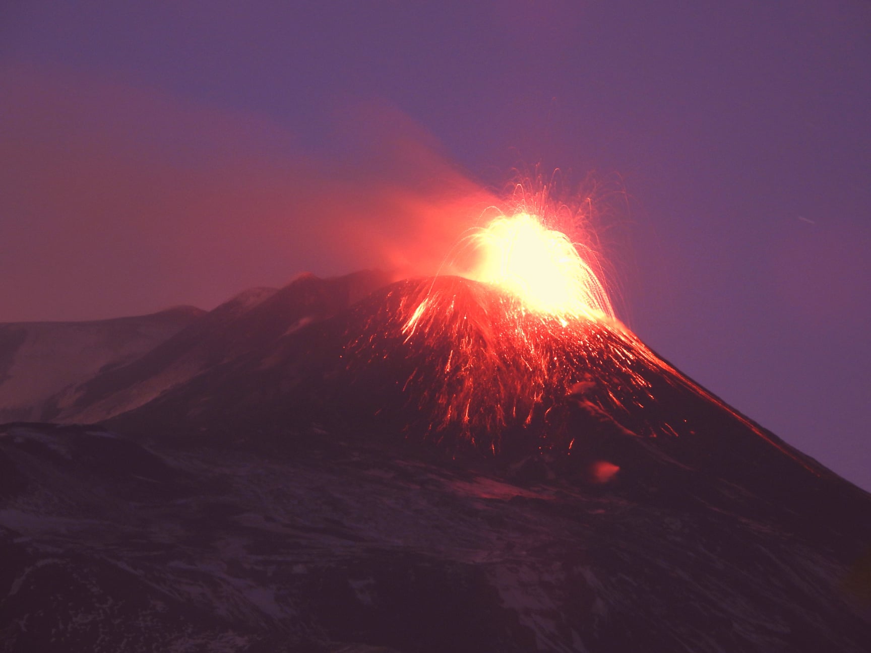
From 8:00 p.m. GMT, the average amplitude of the volcanic tremor showed a clear and rapid decrease and after about an hour it reached values quite comparable to those which preceded the eruptive phase described in the previous update. (update n ° 126). At present, however, the amplitude remains limited to the high value range. The location of the source of the tremor showed no variation, remaining located under the Southeast crater, at a depth of about 2900m.
The infrasonic activity continues to be very sustained, characterized by a high frequency of occurrence and a high energy of infrasonic transients.
The distortion data from the GPS and inclinometric networks did not show any significant changes.
Further updates will be communicated shortly.
Source : INGV .
Photos : Gio Giusa , INGV .
Philippines , Taal :
TAAL VOLCANO BULLETIN: 16 February 2021 08:00 A.M.
In the past 24-hour period, the Taal Volcano Network recorded ninety-eight (98) tremor episodes having durations of five (5) to twelve (12) minutes. Activity in the Main Crater consisted of weak emission of white steam-laden plumes from fumaroles that rose 5 meters high. Temperature highs of 77.1°C and pH of 1.59 were last measured from the Main Crater Lake on 12 February 2021. Ground deformation parameters from continuous electronic tilt on Volcano Island record a slight deflation around the Main Crater since October 2020 but overall, very slow and steady inflation of the Taal region has been recorded by continuous GPS data after the eruption.
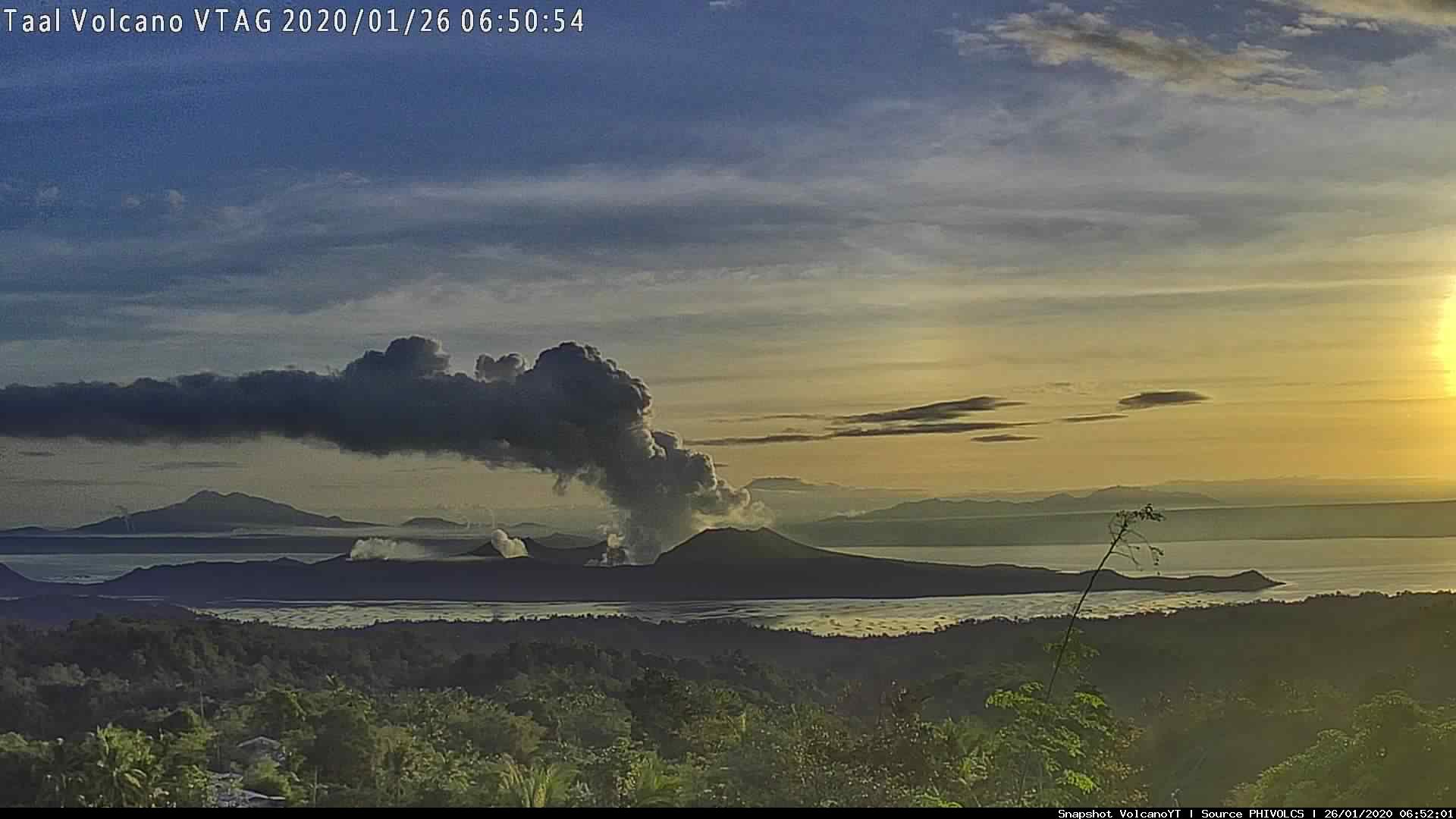
Alert Level 1 (Abnormal) is maintained over Taal Volcano. DOST-PHIVOLCS reminds the public that at Alert Level 1, sudden steam-driven or phreatic explosions, volcanic earthquakes, minor ashfall, and lethal accumulations or expulsions of volcanic gas can occur and threaten areas within the Taal Volcano Island (TVI). DOST-PHIVOLCS strongly recommends that entry into TVI, Taal’s Permanent Danger Zone or PDZ, especially the vicinities of the Main Crater and the Daang Kastila fissure, must remain strictly prohibited. Local government units are advised to continuously assess previously evacuated barangays around Taal Lake for damages and road accessibilities and to strengthen preparedness, contingency, and communication measures in case of renewed unrest. People are also advised to observe precautions due to ground displacement across fissures, possible ashfall, and minor earthquakes. Civil aviation authorities must advise pilots to avoid flying close to the volcano as airborne ash and ballistic fragments from sudden explosions and wind-remobilized ash may pose hazards to aircraft.
DOST-PHIVOLCS is closely monitoring Taal Volcano’s activity and any new significant development will be immediately communicated to all stakeholders.
Source er photo : Phivolcs.
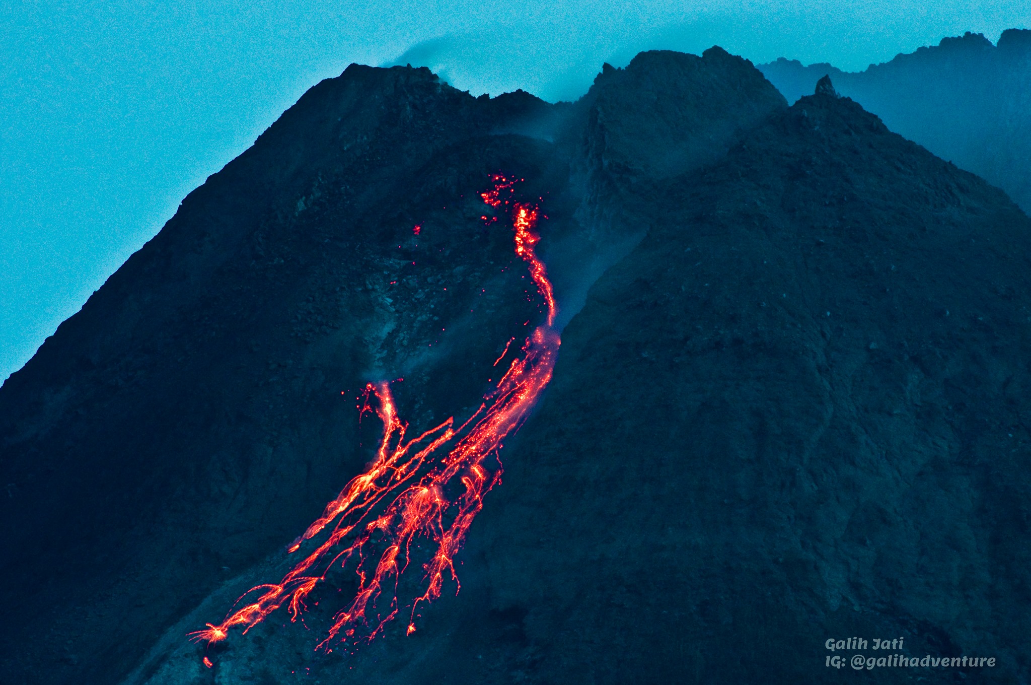
Indonesia , Merapi :
Mount Merapi activity report from February 05 to 11, 2021.
OBSERVATION RESULTS
Visual
The weather around Mount Merapi is generally sunny in the morning, while the afternoon until evening is foggy. There is white smoke, thin to thick with low pressure. A maximum smoke height of 50m was observed from the Kaliurang observation post on February 9, 2021 at 5:35 a.m. WIB.
Morphological analysis of the summit area based on photos of the southwest sector from February 11 to February 4, 2021 showed a change in the morphology of the area due to avalanche activity. On February 11, 2021, the volume of the 2021 lava dome on the South West Cliff was measured at 295,000 m3 with a growth rate of 48,900 m3 / day. During this time, the growth of the lava dome in the crater cannot be observed due to weather constraints.
Seismicity
This week, the seismicity of Mount Merapi recorded:
22 shallow volcanic earthquakes (VTB),
193 multi-phase earthquake (MP),
775 avalanche earthquakes (RF),
10 emission earthquakes (DG)
13 tectonic earthquakes (TT).
The seismic intensity this week is higher than last week.
Deformation
The deformation of Mount Merapi which was monitored using EDM and GPS this week showed no significant changes.
Rain and lahars
This week, there was rain at Mount Merapi Observation Post with the highest rainfall intensity of 92mm / hour for 60 minutes at Kaliurang Post on February 5, 2021. There was no rain. lahars or additional flow in the rivers that descend from Mount Merapi.
Conclusion
Based on the results of visual and instrumental observations, it is concluded that:
The volcanic activity of Mount Merapi is still quite high in the form of effusive eruption activity. The status of the activity is defined at the “SIAGA” level.
Mount Merapi, straddling Central Java and Yogyakarta provinces, spewed red hot lava 12 times, with a maximum glide distance of 1.5 kilometers in the southwesterly direction between midnight and 6 a.m. local time on Tuesday.
During the time when the volcano erupted, 38 earthquake avalanches were recorded, with an amplitude of 3-24 mm for a duration of 12.8-96.8 seconds and a multi-phase earthquake, with an amplitude of 3 mm for nine seconds, noted the Head of the Geological Disaster Research and Technology Development Center (BPPTKG) Hanik Humaida in a written statement released on Tuesday.
Source : BPPTKG , Antaranews .
Photo : Yohannes Tyas Galih Jati .
Peru , Sabancaya :
Analysis period: from February 08, 2021 to February 14, 2021, Arequipa, February 15, 2021.
Alert level: ORANGE
The Geophysical Institute of Peru (IGP) reports that the eruptive activity of the Sabancaya volcano remains at moderate levels, that is, with the recording of an average of 76 daily explosions, with columns of ash and of gas up to an altitude of 3.0 km above the summit of the volcano and their consequent dispersion. Therefore, for the following days, no significant change is expected in the eruptive activity.
The IGP recorded and analyzed the occurrence of 1447 earthquakes of volcanic origin, associated with the circulation of magmatic fluids inside the Sabancaya volcano. An average of 76 explosions was recorded daily. During this period, Volcano-Tectonic (VT) earthquakes associated with rock fracturing were located mainly in the North-East of Sabancaya and presented magnitudes between M2.2 and M2.8.
The monitoring of the deformation of the volcanic structure using GNSS techniques (processed with fast orbits) does not present any significant anomalies. However, in general, an inflation process has been observed in the south-eastern sector of Sabancaya and the northern sector (around the Hualca Hualca volcano). The visual surveillance made it possible to identify columns of gas and ash up to 3.0 km altitude above the summit of the volcano, which were scattered towards the South-West, West, North-West and North-West sectors. East of Sabancaya. Satellite monitoring identified the presence of 4 thermal alerts, with values between 3 and 16 MW which are associated with the presence of a lava dome on the surface of the volcano crater.
RECOMMENDATIONS
• Keep the volcanic alert level in orange.
• Do not approach within a radius of less than 12 km from the crater.
Source et photo : IGP.
Guatemala , Fuego :
SPECIAL VOLCANOLOGICAL BULLETIN
END OF ERUPTION
As part of the follow-up to the eruption of the Fuego volcano and the BEFGO-22 2021 bulletin, it is reported that in the last hours, this activity has remained in a gradual decrease, which is reflected in the seismic stations, the levels of radiation and explosive rate. The RSAM graph (Figure 1) reflects the decrease in energy and its tendency to stay close to normal parameters.
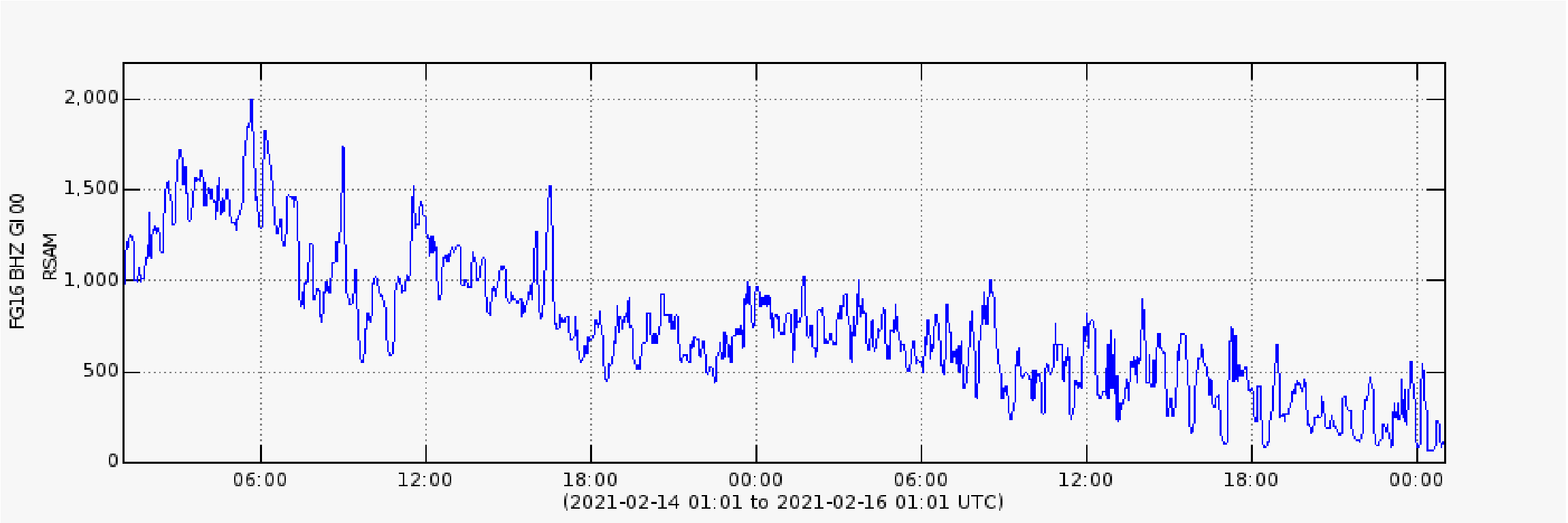
Figure 1: FG16 mean seismic amplitude graph.
Therefore, the effusive eruption is considered to be over. The westward flow towards the Seca ravine has disappeared, while the southwest flow towards the Ceniza ravine is 300 meters long and is expected to reduce this length in the coming hours. The number of explosions remains between 12 and 14 per hour, expelling ash columns to a height of 4800 meters above sea level (15,748 feet) moving in a northeast, north and east direction, with the probability of reach distances of up to 130 kilometers. Due to the direction of the wind, the likelihood of continuing to bring fine ash to the capital and surrounding municipalities is high.

In the hours or days to come, there should continue to be recorded moderate to strong explosions, accompanied by rumbling, shock waves, sounds of degassing and avalanches through the various ravines.
Source : Insivumeh


No comment yet, add your voice below!