
February 12 , 2021.
Indonesia , Sinabung :
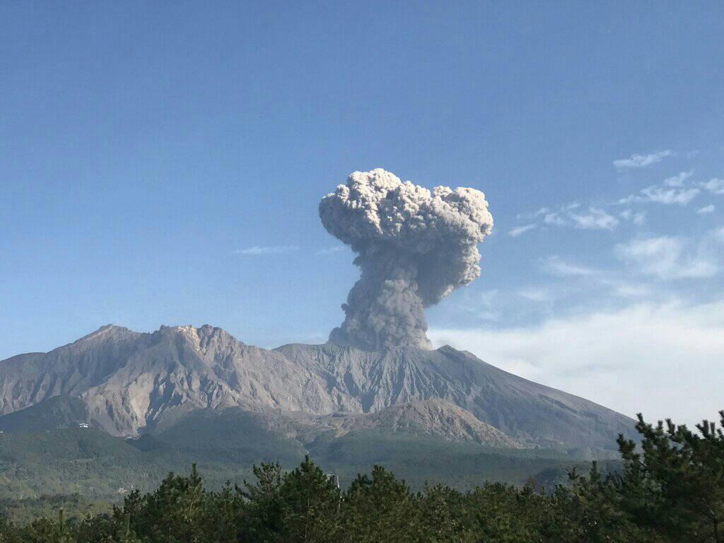
PVMBG reported that the eruption at Sinabung continued during 3-9 February, though weather conditions sometimes prevented visual confirmation. Dense white plumes rose as high as 1 km above the summit and drifted in multiple directions. An eruptive event was recorded on 5 February but was not seen, and on 6 February a pyroclastic flow traveled 2.5 km down the flank. The Darwin VAAC noted that ash plumes rose to 3 km (10,000 ft) a.s.l. and drifted W and NNW that same day. On 7 February ash plumes rose 1 km above the summit and drifted E, SE, and S, causing ashfall in the Karo Regency. The Alert Level remained at 3 (on a scale of 1-4), with a general exclusion zone of 3 km and extensions to 5 km in the SE sector and 4 km in the NE sector.
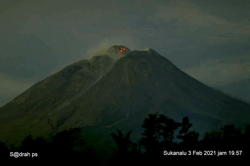
The activity level has been at level III (SIAGA) since May 20, 2019 at 10:00 a.m. WIB. Mount Sinabung (2460 m above sea level) has been erupting since 2013.
The volcano is clearly visible until it is covered in fog. We observe that the crater emits white smoke with a strong thickness, rising about 50-500 meters above the summit. The weather is sunny to cloudy, with weak to moderate winds to the east and southeast. The air temperature is around 18-26 ° C.
According to the seismographs of February 11, 2021, it was recorded:
1 hot cloud avalanche earthquake
180 avalanche earthquakes
17 earthquakes of emissions
11 low frequency earthquakes
65 hybrid / multi-phase earthquakes
1 deep volcanic earthquake – 4 shallow tectonic earthquakes
Source : GVP , PVGMB
Photo : Sadrah Ps.
Hawaii , Kilauea :
19°25’16 » N 155°17’13 » W,
Summit Elevation 4091 ft (1247 m)
Current Volcano Alert Level: WATCH
Current Aviation Color Code: ORANGE
Activity Summary:
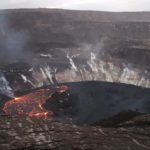
Kīlauea Volcano is erupting. Lava activity is confined to Halemaʻumaʻu with lava erupting from a vent on the northwest side of the crater. As of the evening of February 9, the lava in the western active portion of the lake in Halema‘uma‘u was about 214 m (702 ft) deep, with the eastern portion of the lava lake solidified at the surface. SO2 emission rates remain elevated.
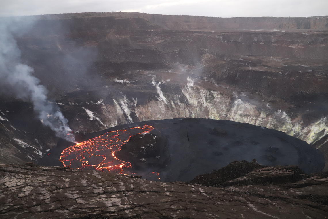
Twilight view of the lava lake in Halema‘uma‘u at Kīlauea Volcano’s summit. This photo, taken from the southern rim of Halema‘uma‘u crater and looking northward, shows the active western (left) portion of the lava lake, which has hot incandescent lava visible at boundaries between plates on the lava lake. The inactive eastern (right) portion of the lake appears dark.
Summit Observations:
The most recent sulfur dioxide emission rate measurements from February 10 are about 1,600 t/d—lower than the emission rates from the pre-2018 lava lake (around 5,000 t/d). The summit tiltmeters show inflationary tilt continuing today. Seismicity remains elevated but stable, with elevated tremor and a few minor earthquakes.
Halemaʻumaʻu lava lake Observations:
Lava from the west vent continues to supply the lava lake within Halema‘uma‘u crater.
The active western half of the lava lake was approximately 215 m (705 ft) deep on February 10, 2021. The stagnant eastern half of the lake remained about 15 feet lower than the active western half. Lava lake activity in the western half consisted of slow crustal movement at the base of the lava stream and crustal overturning at plate boundaries on the rest of the active portion.
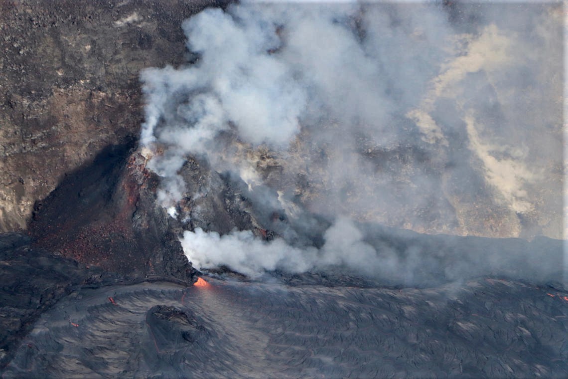
A zoomed-in aerial view of the active west vent in Halema‘uma‘u crater taken during the helicopter overflight on February 9. Lava erupted from the west vent continues to enter the active lava lake through an inlet at the base of the cone. SO2 emission rates remain elevated and were measured at 2,200 t/d on February 1.
Source : HVO.
Photos : USGS / N. Deligne , B. Carr.
Kamchatka , Klyuchevskoy :
VOLCANO OBSERVATORY NOTICE FOR AVIATION (VONA).
Issued: February 11 , 2021
Volcano: Klyuchevskoy (CAVW #300260)
Current aviation colour code: YELLOW
Previous aviation colour code: orange
Source: KVERT
Notice Number: 2021-23
Volcano Location: N 56 deg 3 min E 160 deg 38 min
Area: Kamchatka, Russia
Summit Elevation: 4750 m (15580 ft)
Volcanic Activity Summary:
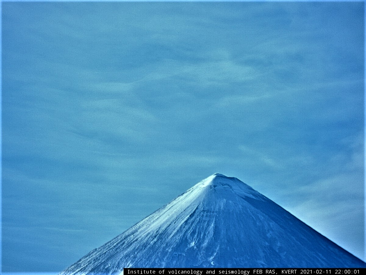
The explosive-effusive eruption of the volcano is over. According to seismic data by KB GS RAS (http://www.emsd.ru/~ssl/monitoring), the magnitude of volcanic tremor decreased from 34 to 0.89 mkm/s from 07 to 08 February. Temperature of the thermal anomaly of the volcano dropped sharply on 07 February, and continues to decline. There was no Strombolian activity on the night of 11-12 February. Only weak fumarole activity of the volcano is noting. Probably on 08 February, 2021, can be considered the end of the eruption. Activity of the volcano continues, and the danger of ash explosions remains. KVERT continues to monitor Klyuchevskoy volcano.
A moderate gas-steam activity of the volcano continues. The danger of ash explosions up to 19,700-23,000 ft (6-7 km) a.s.l. remains. Ongoing activity could affect low-flying aircraft.
Volcanic cloud height: NO ASH CLOUD PRODUSED
Other volcanic cloud information: NO ASH CLOUD PRODUSED
Source : Kvert
Photo : IVS FEB RAS, KVERT
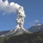
Japan , Sakurajima :
JMA reported that during 29 January-1 February incandescence from Minamidake Crater (at Aira Caldera’s Sakurajima volcano) was often visible nightly. Seven explosions generated eruption plumes that rose as high as 2 km above the crater rim and ejected bombs 1,000-1,300 km away from the crater. The sulfur dioxide emission rate was 1,100 tons per day on 2 February. The Alert Level remained at 3 (on a 5-level scale).
The Aira caldera in the northern half of Kagoshima Bay contains the post-caldera Sakurajima volcano, one of Japan’s most active. Eruption of the voluminous Ito pyroclastic flow accompanied formation of the 17 x 23 km caldera about 22,000 years ago. The smaller Wakamiko caldera was formed during the early Holocene in the NE corner of the Aira caldera, along with several post-caldera cones. The construction of Sakurajima began about 13,000 years ago on the southern rim of Aira caldera and built an island that was finally joined to the Osumi Peninsula during the major explosive and effusive eruption of 1914. Activity at the Kitadake summit cone ended about 4850 years ago, after which eruptions took place at Minamidake. Frequent historical eruptions, recorded since the 8th century, have deposited ash on Kagoshima, one of Kyushu’s largest cities, located across Kagoshima Bay only 8 km from the summit. The largest historical eruption took place during 1471-76.
Source : GVP , JMA.
Photo : Rizal M.
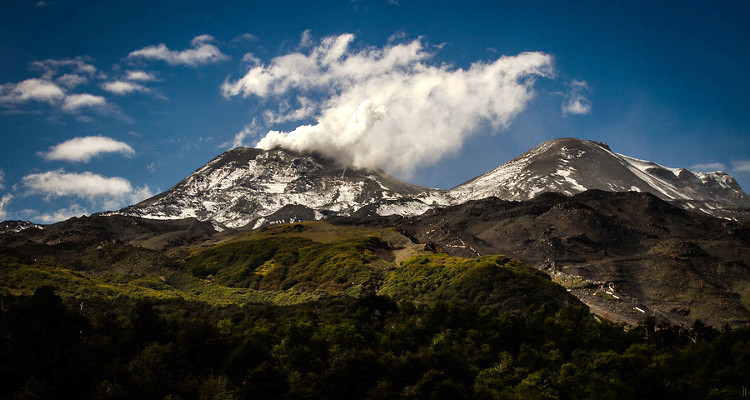
Chili , Nevados of Chillan :
Special Report on Volcanic Activity (REAV), Ñuble region, Nevados de Chillán volcanic complex, February 11, 2021, 5:30 p.m. local time (Continental Chile).
The National Service of Geology and Mines of Chile (Sernageomin) publishes the following PRELIMINARY information, obtained thanks to the monitoring equipment of the National Volcanic Surveillance Network (RNVV), processed and analyzed in the Volcanological Observatory of the Southern Andes ( Ovdas):
Yesterday, Thursday February 11, at 5:16 p.m. local time (20:16 UTC), the monitoring stations installed near the volcanic complex of Nevados de Chillán recorded an earthquake linked to the fracturing of the rock (Volcano-Tectonic).
The characteristics of the earthquake after its analysis are as follows:
TIME OF ORIGIN: 17:16 local time (20:16 UTC)
LATITUDE: 36.876 ° S
LONGITUDE: 71.366 ° W
DEPTH: 3.4 km
LOCAL MAGNITUDE: 3.6 (ML)
OBSERVATIONS:
No surface activity associated with this seismic event was observed. At the time of issuing this report, the seismicity maintains a level similar to that present before the event. There are no reports on how this event was felt by surrounding communities.
The volcanic technical alert remains at the Yellow level.
Source : Sernageomin .
Photo : agence uno , biobiochiles


No comment yet, add your voice below!