
July 31 , 2020.
Hawaii , Mauna Loa :
19°28’30 » N 155°36’29 » W,
Summit Elevation 13681 ft (4170 m)
Current Volcano Alert Level: ADVISORY
Current Aviation Color Code: YELLOW
Activity Summary:
Mauna Loa Volcano is not erupting. Rates of deformation and seismicity have not changed significantly over the past week and remain above long-term background levels.
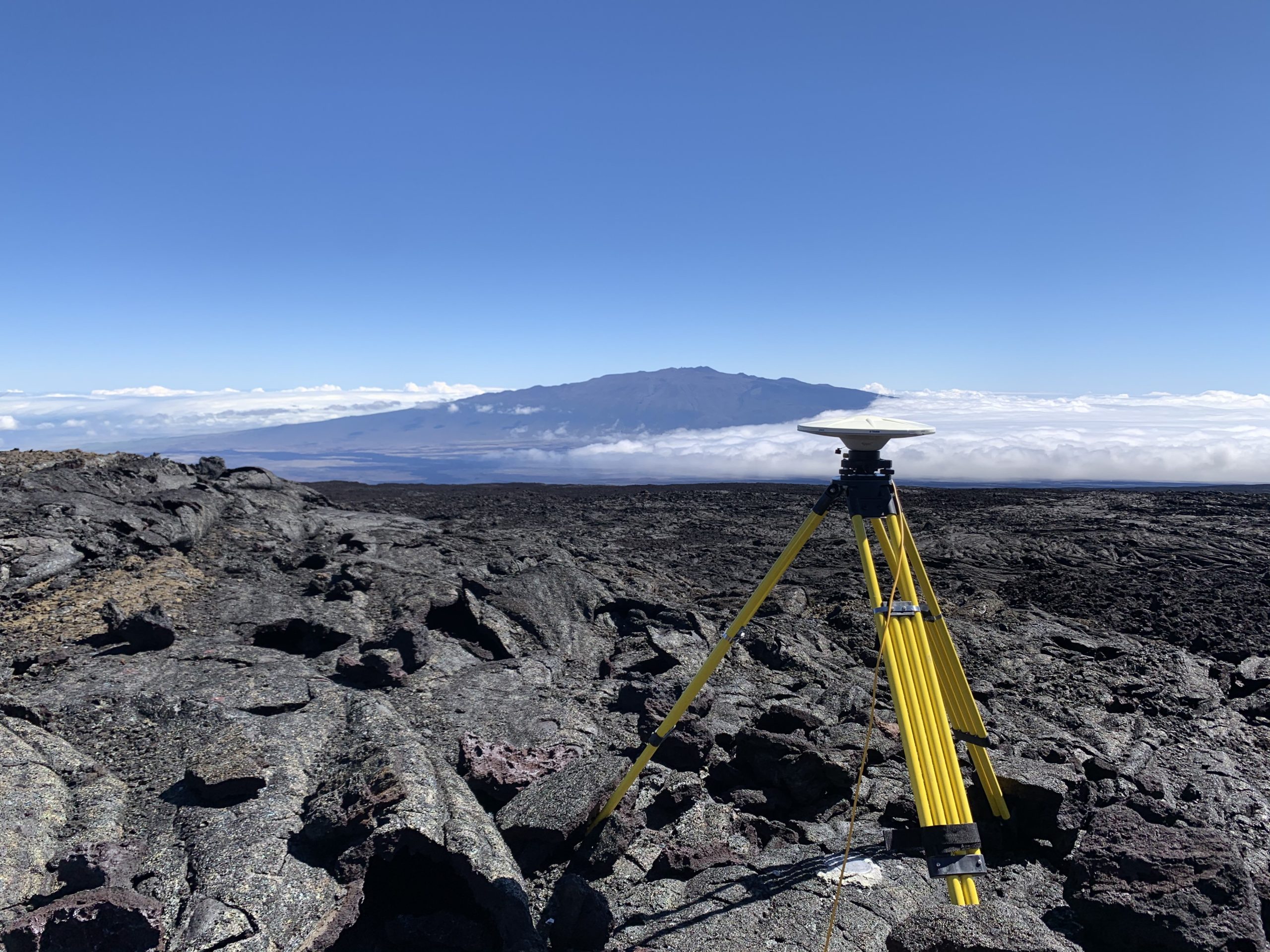
Over the past several weeks, HVO geophysicists have been conducting the annual high-precision Global Positioning System (GPS) survey of Mauna Loa, which supplements HVO’s continuous GPS monitoring stations. The annual GPS surveys provide information on vertical and horizontal deformation, informing HVO about the volume changes within subsurface magma reservoirs at Mauna Loa. This station was located on the north flank of Mauna Loa, with Mauna Kea (hugged by clouds on its east side) visible in the background. USGS photo by S. Conway.
Observations:
During the past week, HVO seismometers recorded 105 small-magnitude earthquakes on the volcano’s summit and upper-elevation flanks. Most of these earthquakes occurred at shallow depths of less than 8 kilometers (~5 miles) below ground level.
Global Positioning System (GPS) measurements show continued slow summit inflation, consistent with magma supply to the volcano’s shallow storage system.
Gas concentrations at the Summit and Sulphur Cone monitoring sites remain stable (below 2 ppm SO2). Fumarole temperatures as measured at both Sulphur Cone and the summit are ~98 C and are in the normal range.
Webcams show no changes to the landscape.
Source : HVO
Philippines , Kanlaon / Mayon / Taal / Bulusan :
KANLAON VOLCANO BULLETIN 31 July 2020 08:00 A.M.

Kanlaon Volcano’s monitoring network recorded three (3) volcanic earthquakes during the 24-hour observation period. Sulfur dioxide (SO2) emission was measured at an average of 723 tonnes/day on 26 July 2020. Ground deformation data from continuous GPS measurements indicate a slight deflation of the lower and mid slopes since January 2020. However, short-term electronic tilt monitoring on the southeastern flanks recorded inflation on the lower to mid slopes that began on June 21, 2020. These parameters indicate hydrothermal or magmatic processes occurring beneath the edifice.
MAYON VOLCANO BULLETIN 31 July 2020 08:00 A.M.
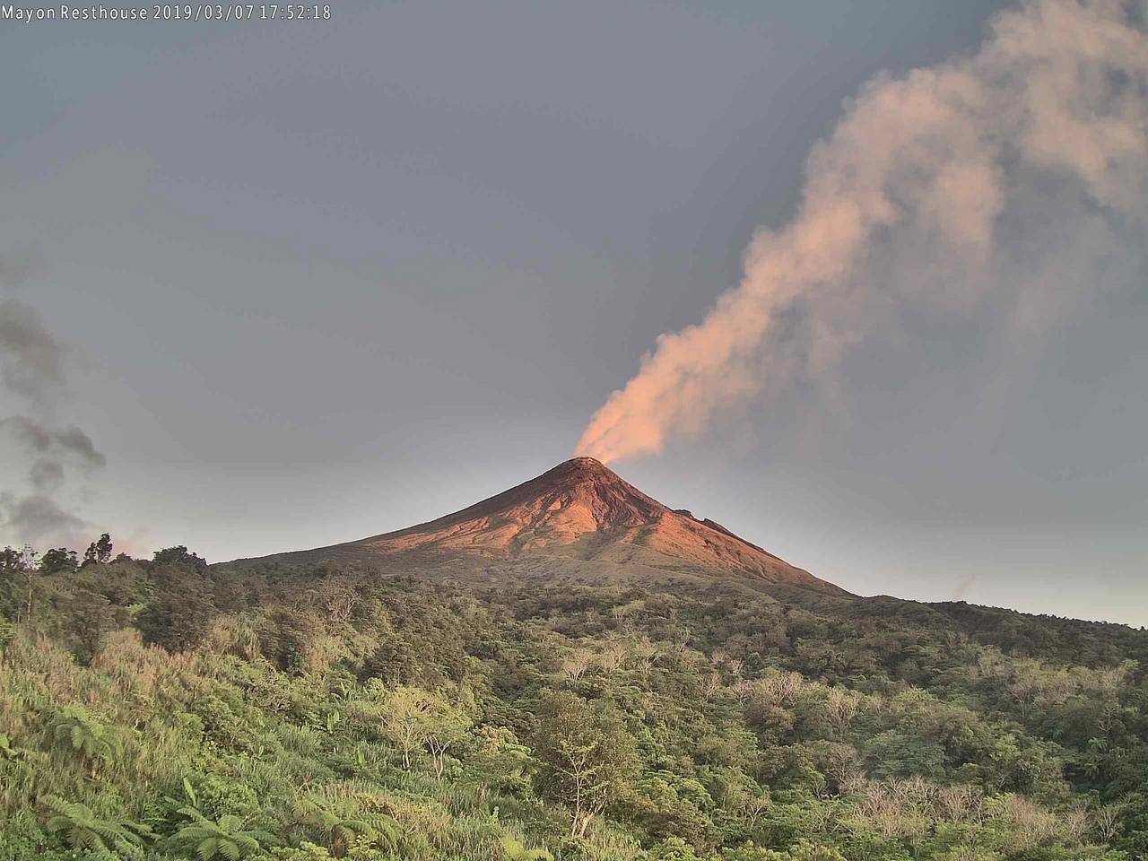
Mayon Volcano’s monitoring network did not detect any volcanic earthquake during the 24-hour observation period. Sulfur dioxide (SO2) emission was last measured at an average of 222 tonnes/day on 23 July 2020. Ground deformation data from Precise Leveling surveys on 12–19 June 2020 indicated slight inflation of the edifice relative to the February 2020 survey. Electronic tilt data also indicated non-steady inflation of the middle to upper edifice that began in late 2019. This follows an inflationary trend that has been recorded by continuous GPS monitoring since the middle of 2019.
TAAL VOLCANO BULLETIN 31 July 2020 08:00 A.M.
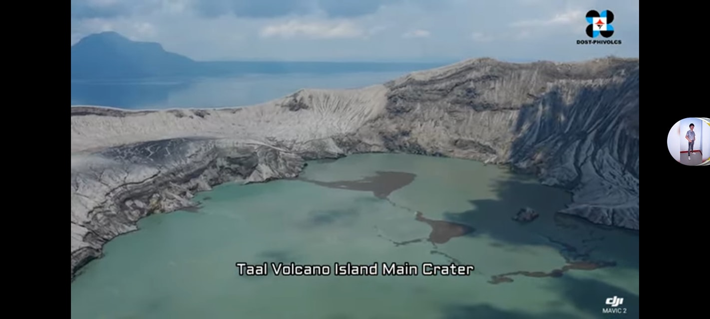
In the past 24-hour period, the Taal Volcano Network recorded one (1) volcanic earthquake that is associated mainly with rock-fracturing processes beneath and around the edifice. Weak steaming or fumarolic activity rising 20 meters high before drifting southwest was observed from vents on the Main Crater and fissure vents along the Daang Kastila Trail.
BULUSAN VOLCANO BULLETIN 31 July 2020 08:00 A.M.
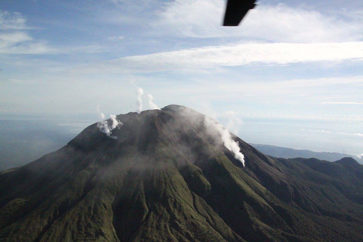
Bulusan Volcano’s monitoring network did not detect any volcanic earthquake during the 24-hour observation period. Ground deformation data from continuous GPS measurements indicate a cycle of inflation followed by deflation of the edifice beginning late February 2020, while the long-term trend since May 2019 denotes that the edifice is still deflated. These parameters indicate that volcanic processes are underway beneath the edifice that may be caused by deep-seated degassing or hydrothermal activity or magmatic intrusion.
Source : Phivolcs
Photos : Phivolcs , Volcanodiscovery , Phivolcs , Phivolcs .
Colombia , Chiles / Cerro Negro :
Weekly activity bulletin of Chiles and Cerro Negro volcanoes
Volcanic activity continues at: YELLOW LEVEL ■ (III): CHANGES IN THE BEHAVIOR OF VOLCANIC ACTIVITY.

From the follow-up of the activity of the VOLCANS CHILES AND CERRO NEGRO, the COLOMBIAN GEOLOGICAL SERVICE (SGC) reports that:
Compared to the previous week, during the period evaluated from July 21 to 27, 2020, there has been an increase in the frequency of earthquakes recorded in the region of the Chiles – Cerro Negro volcanoes. The prevalence of events associated with the rock fracture is maintained, with local magnitudes less than M 1.6, which were located in two main sources: a closer, south of the Chiles volcano, with epicentral distances of up to 4. km and depths less than 6 km from the summit (about 4700 m altitude); and another more distal, to the south-east of the Chiles volcano (epicentral distance up to 13 km and depth less than 12 km).
The changes recorded by the volcanic deformation sensors continue. The other volcanic monitoring parameters did not show significant variations and no manifestation of surface activity was observed.
Source : SGC .
Photo : hablemosdevolcanes.com.
Mexico , Popocatepetl :
July 30, 11:00 a.m. (July 30, 4:00 p.m. GMT)
During the last 24 hours, according to the monitoring system of the Popocatépetl volcano, 12 exhalations have been identified, accompanied by volcanic gases and sometimes small amounts of ash. In addition, 1,250 minutes of low to medium amplitude tremor associated with the emission of water vapor, gas and light amounts of ash were recorded, with heights of up to 1,000 m, dispersing in a West-North-West direction. During constant emissions, incandescent fragments projected a short distance from the crater were also observed.
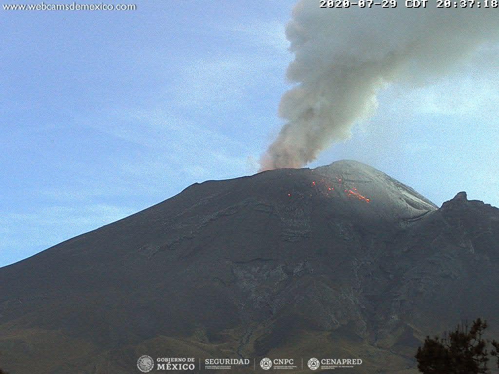
At night, there was partial visibility of the volcano, however, an incandescence could be observed above the crater.
From the morning and now, a constant emission of water vapor, gas and small amounts of ash is observed in a West-North-West direction.
Derived from the activity of the volcano, the National Center for the Operation of Communication and Civil Protection (CENACOM) reported a slight fall of ash in the municipalities of Amecameca and Ozumba belonging to the State of Mexico.
CENAPRED urges NOT TO APPROACH the volcano and especially the crater, because of the danger involved by the fall of ballistic fragments and, in the event of heavy rains, to move away from the bottom of the ravines because of the danger of mudslides and debris.
The Popocatépetl volcanic alert signal light is in YELLOW PHASE 2.
Source : Cenapred .


No comment yet, add your voice below!