
April 07 , 2020 .
La Réunion , Piton de la Fournaise :
Activity bulletin from Monday, April 6, 2020 at 2:30 p.m. (local time)
Recommended alert level: Backup
A sharp fall in the intensity of the tremor was observed today, 06/04/2020, around 1:30 p.m. local time (9:30 a.m. UT; Figure 1), announcing the end of the eruption on the surface.
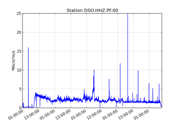
Figure 1: Evolution of the RSAM (indicator of the volcanic tremor and the intensity of the eruption) since 02/04/2020 00h UT time (04h local time) on the seismic station DSO located at the top of the volcano. (© OVPF / IPGP).
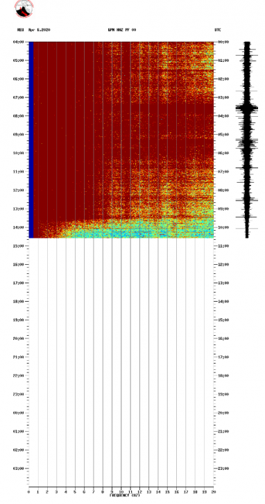
Figure 2: Spectrogram of the GPN seismological station, located in the Great Slopes (© OVPF / IPGP).
No hypothesis is ruled out as for the evolution of the situation to come (final stop, resumption of the activity on the same site, resumption of the activity on another site), taking into account the strong seismicity recorded since the day of 5/4/2020 00h (UT time) and until 09h (UT time; 13h local time) this day: with 243 superficial volcano-tectonic earthquakes (<2km deep) recorded under the summit craters (Figure 3 ). Even if since the end of the eruption the seismic activity has considerably decreased.
Points on the flow before the eruption stopped and Pelé’s hair:
Following a reconnaissance flight by the SAG and the PGHM carried out this morning around 10 am local time, the flow front could be located with precision (white star in Figure 3). The active front (south flow arm) was located at 360 m altitude, about 2 km from national road 2 (against 550 m altitude and 2.7 km from the road yesterday at 10:30 am for the arm North).
Thermal images acquired last night by an OVPF / IPGP team made it possible to estimate a forward speed of the flow front of 40-60 m / h during the evening of 5/4/2020.
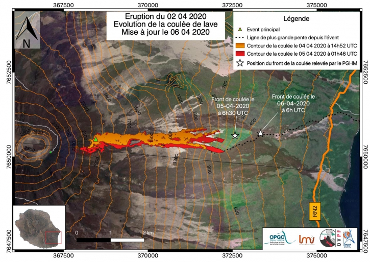
Figure 3: Mapping of the lava flow dated 4/4/2020 (orange) and 5/4/2020 (red) deduced from satellite images. The white stars represent the position of the flow front on 5/4/2020 at 10:30 a.m. local time (6:30 a.m. UT) and 6/4/2020 at 10 a.m. local time (6 a.m. UT). The dotted line represents the line of greatest slope (© OVPF / IPGP / LMV / OPGC).
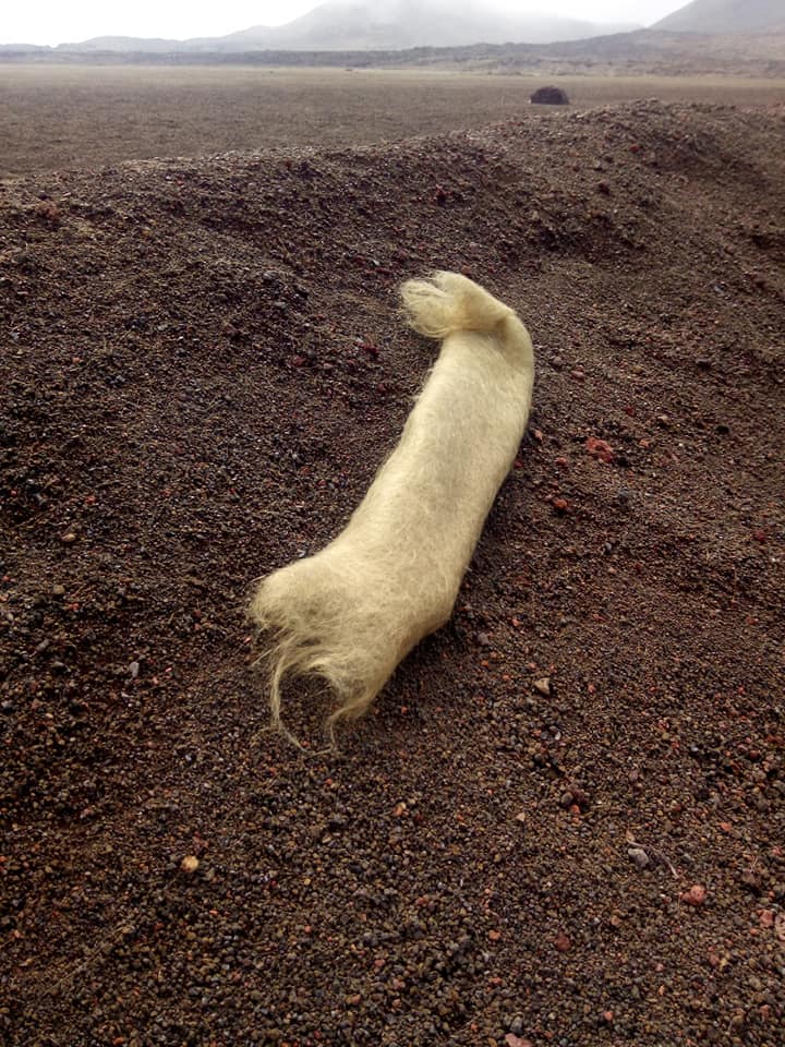
Large quantities of Pelé hair were again reported this morning in the areas located north of the volcano, especially in the La Plaine des Cafres sector where their dispersion was the highest. At the Plaine de Cafres (and especially in the Plaine des sables sector) this hair, gathered under the action of the wind, formed tufts of several tens of cm. There are also reports of hair fallout from Pelé from the Ravine des Cabris (Saint Pierre) to Sainte Marie, via Le Tampon, and the Plains region. This Pelé hair is formed when the lava ejections from the fountains stretch at the level of the eruptive site and are carried by the wind.
* During this confinement period, the OVPF premises are closed but all of the OVPF and IPGP teams remain mobilized to monitor this crisis remotely by telework and rely on a dense network instrumentation (100 permanent sensors installed on the volcano) whose data arrive in real time on the observatory’s servers.
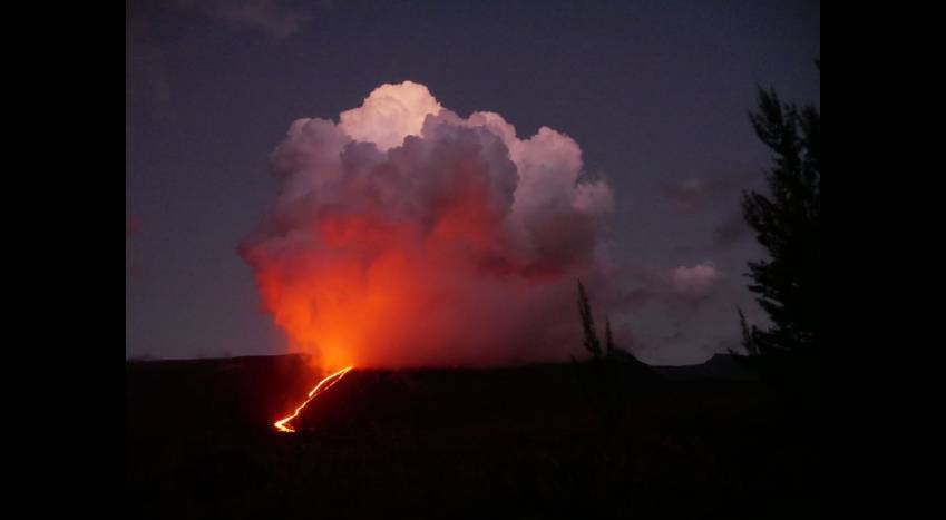
The second eruption of the year, which started on Thursday April 2, stopped yesterday in the early afternoon. In five days, the lava descended the big slopes, then stopped 2 km from the national road.
Yesterday at the start of the evening, the webcams of the volcanic observatory of Piton de La Fournaise (OVPF) still showed signs of life on the front of the flow: the red was still reflected in the sky. The explanation given by the OVPF team on social networks was simple: “Despite the end of the eruption around 1:30 pm, glowing is still visible. These are linked to the lava flows being cooled and to the lava tunnels which drain. Live, confined, the Reunion Islanders witnessed the last breaths of the eruption.
Source : OVPF. Clicanoo.
Read the article : http://www.ipgp.fr/fr/ovpf/bulletin-dactivite-lundi-6-avril-2020-a-14h30-heure-locale
Photos : Tunnels de lave Réunion : Rando-Volcan. FMA/Clicanoo .
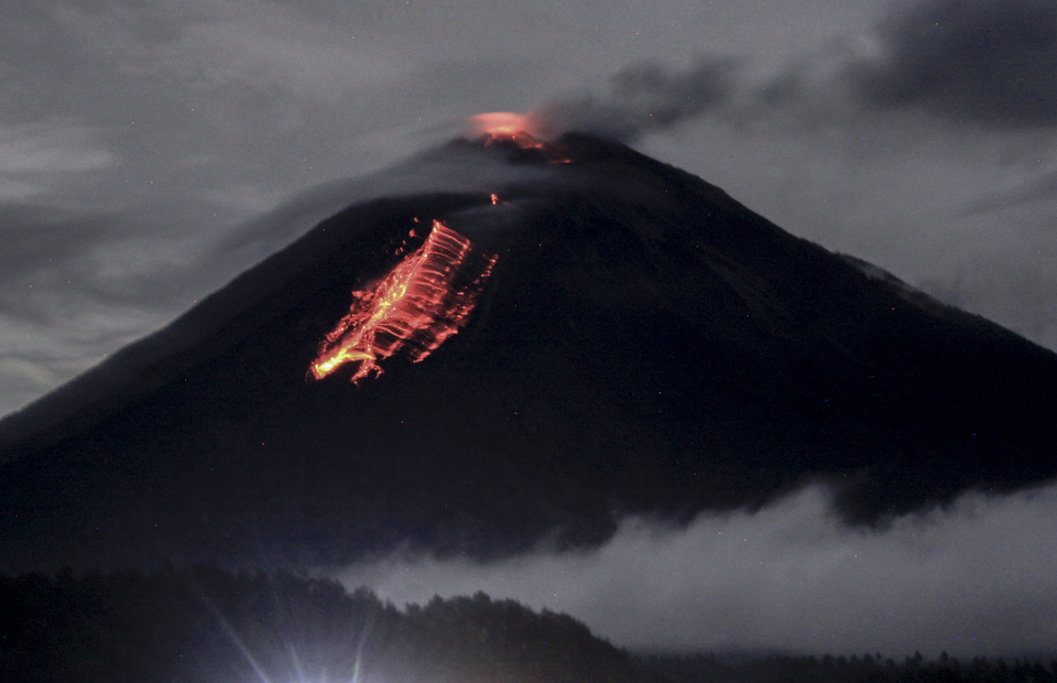
Peru , Sabancaya :
Analysis period: March 30 to April 5, 2020. Arequipa, March 6, 2020.
Alert level: ORANGE
The Peruvian Geophysical Institute (IGP) reports that the eruptive activity of the Sabancaya volcano remains at moderate levels; that is to say with the continuous recording of moderate explosions and consequent emissions of ash and gas. Consequently, for the following days, no significant change is expected regarding its activity.
The IGP recorded and analyzed the occurrence of approximately 362 earthquakes of volcanic origin (long period type earthquakes), associated with the circulation of fluids (magma, gas, etc.) inside the volcano. On April 1, 2020, at 5:50 p.m., an earthquake swarm of earthquakes of magnitude less than M3.4 was recorded. This seismicity was located 14 km northwest of the Sabancaya and 12 km deep. During this period, 9 explosions of low to medium intensity were recorded on average daily.

Monitoring the deformation of the volcanic structure does not record any significant anomalies. Visual surveillance identified columns of gas and ash up to 2 km high above the summit of the volcano, which were mainly dispersed towards the southwest and northeast sectors of the Sabancaya. Satellite surveillance identified the presence of a thermal anomaly worth 3 MW, associated with the presence of a lava dome on the surface of the volcano crater.
Source : IGP
Photo : IGP.
Indonesia , Semeru :
Level of activity at level II (WASPADA). The Semeru volcano (3676 m above sea level) is experiencing a continuous eruption. The last crisis occurred on March 5, 2020 with a height of the eruption column not observed.
The volcano is clearly visible until it is covered with fog. The smoke from the crater is observed to be white in color, with low to moderate intensity about 50 meters above the summit. The weather is sunny / rainy, the winds are light to moderate towards the North, the North-East, the South and the South-West.
According to the seismographs of April 6, 2020, it was recorded:
9 explosion / eruption earthquakes
11 avalanche earthquakes
10 emission earthquakes
2 harmonic earthquakes
1 shallow volcanic earthquake
3 deep volcanic earthquakes
1 local tectonic earthquake
2 distant tectonic earthquakes
1 flood earthquake.
Recommendation:
The community must not carry out activities within a radius of 1 km and in the area up to 4 km towards the south-south-east slope sector of the active crater which is an opening area of the active crater of G. Semeru (Jongring Seloko) as a channel for sliding warm clouds.
Be aware of the presence of a lava dome in the Seloko Jongring crater.
VONA: The last VONA code sent had the color code ORANGE, published on March 6, 2020 at 05:31:00. Volcanic ash was observed at an altitude of 3876 m above sea level or about 200 m above the summit.
Source : PVMBG .
Photo : Umarul Faruq.
Kamchatka , Klyuchevskoy :
VOLCANO OBSERVATORY NOTICE FOR AVIATION (VONA).
Issued: April 6 , 2020 .
Volcano: Klyuchevskoy (CAVW #300260)
Current aviation colour code: ORANGE
Previous aviation colour code: orange
Source: KVERT
Notice Number: 2020-39
Volcano Location: N 56 deg 3 min E 160 deg 38 min
Area: Kamchatka, Russia
Summit Elevation: 15580 ft (4750 m)
Volcanic Activity Summary:
A moderate explosive eruption of the Strombolian and sometimes Vulcanian types of the volcano continues. According to video and satellite data, a gas-steam plume containing some amount of ash is extending for 68 km to the east-northeast of the volcano.
A moderate explosive eruption of the volcano continues. Ash explosions up to 16,400-23,000 ft (5-7 km) a.s.l. could occur at any time. Ongoing activity could affect low-flying aircraft.
Volcanic cloud height:
16400-18040 ft (5000-5500 m) AMSL Time and method of ash plume/cloud height determination: 20200406/2230Z – Video data
Other volcanic cloud information:
Distance of ash plume/cloud of the volcano: 42 mi (68 km)
Direction of drift of ash plume/cloud of the volcano: ENE / azimuth 77 deg
Time and method of ash plume/cloud determination: 20200406/2200Z – Himawari-8
Source : Kvert .
Mexico , Popocatepetl :
April 06, 11:00 a.m. (April 06, 4:00 p.m. GMT)
In the past 24 hours, according to the monitoring systems of the Popocatépetl volcano, 100 exhalations have been identified, accompanied by water vapor, volcanic gases and small amounts of ash. The ash emissions were dispersed in the North West (NW) sector. Three volcano-tectonic earthquakes were also detected, one yesterday at 7:49 p.m. and two today at 1:27 a.m. and 6:24 a.m. (local), with a calculated magnitude of 2.1, 1.7 and 1.7, respectively. Finally, 499 minutes of tremors were recorded.
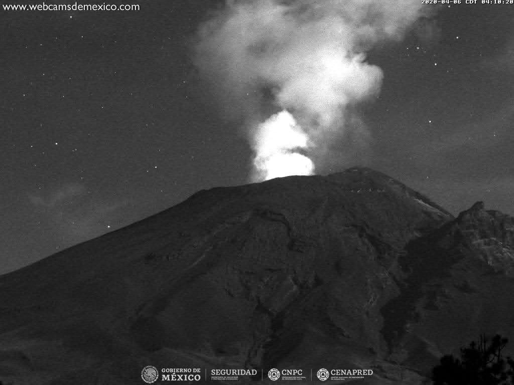
At the time of writing, volcanic gas and light ash emissions were scattered to the northwest (NW).
CENAPRED urges NOT to get close to the volcano and especially the crater, because of the danger involved in the fall of ballistic fragments and, in the event of heavy rain, to move away from the bottom of the ravines because of the danger of mud and rubble.
The Popocatépetl volcanic alert signaling light is in YELLOW PHASE 2.
Source : Cenapred .


No comment yet, add your voice below!