
February 11 , 2018.
Mayon , Philippines :
MAYON VOLCANO BULLETIN 11 February 2018 08:00 A.M.
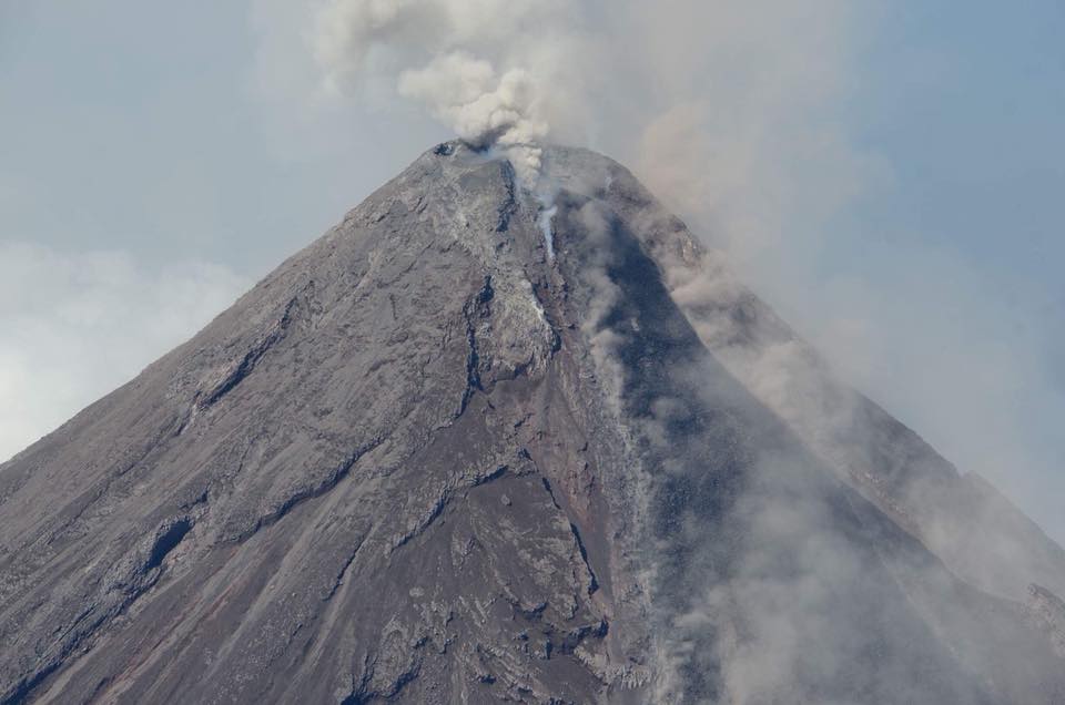
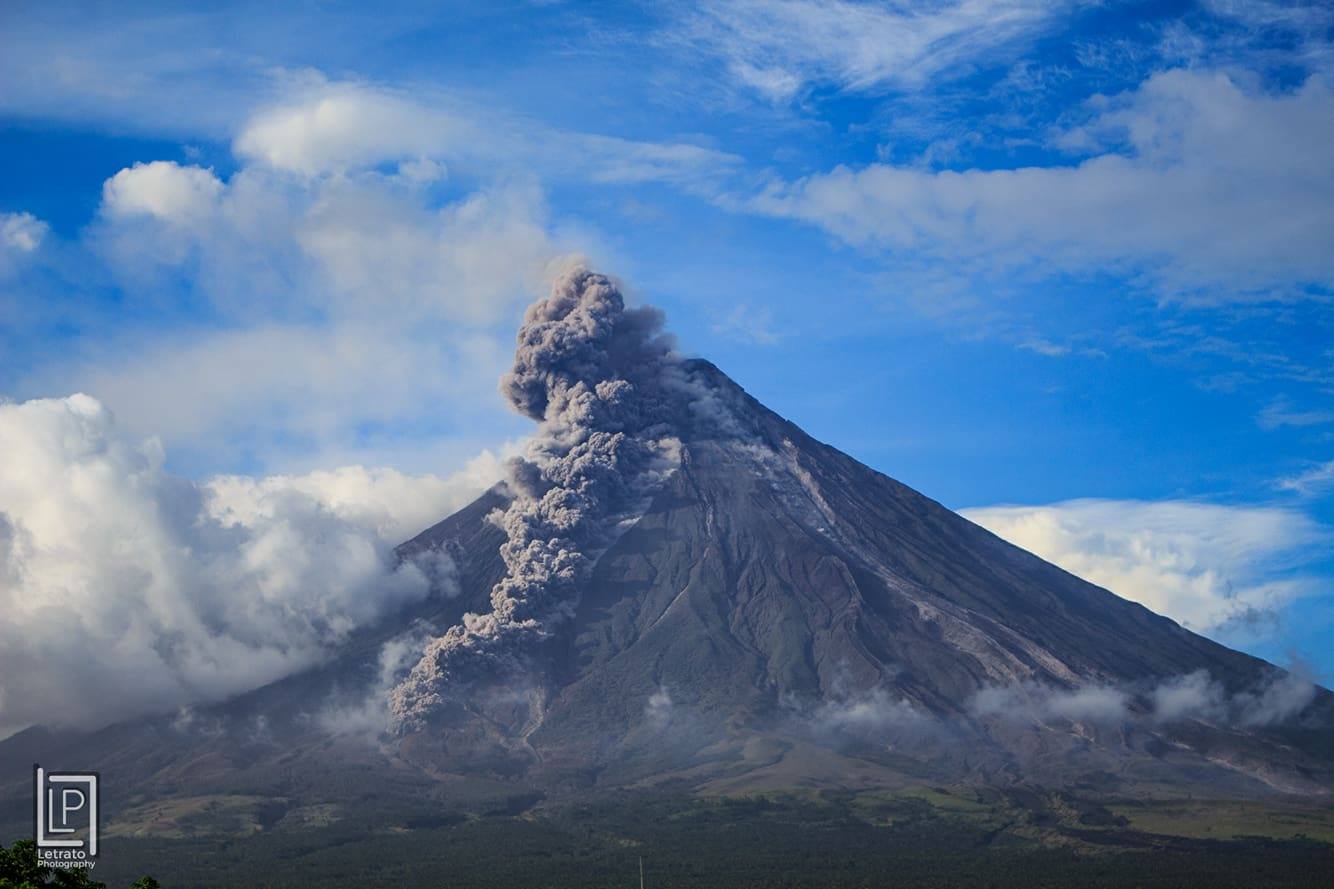
Mayon’s activity in the past 24 hours was characterized by sporadic and weak lava fountaining, lava flow and degassing from the summit crater. Discrete episodes of lava fountaining lasted four (4) to seven (7) minutes were accompanied by rumbling sounds audible beyond 10 kilometers of the summit crater. Incandescent lava fountains 400 meters tall generated steam-laden plumes that rose up to 800 meters from the summit before drifting southwest, west southwest, north northwest, and northwest. Throughout the night, lava flows and consequent incandescent rockfalls were observed in the Miisi and Bonga-Buyuan channels. Effused volumes of incandescent lava flows have advanced to 3.3 kilometers, 4.5 kilometers and 900 meters down the Miisi, Bonga and Basud Gullies, respectively, from the summit crater. Pyroclastic density currents or PDCs have deposited to the 4.6, 4.5 and 4.2 kilometer reaches of the Miisi, Bonga and Basud Gullies, respectively.
Flight over Mayon Volcano, 09 February 2018.
A total of one hundred eight (108) volcanic earthquakes, most of which corresponded to lava fountaining events were recorded by Mayon’s seismic monitoring network. Electronic tilt and continuous GPS still record sustained swelling or inflation of the edifice since November and October 2017, consistent with pressurization by magmatic intrusion.
Alert Level 4 remains in effect over Mayon Volcano. The public is strongly advised to be vigilant and desist from entering the eight (8) kilometer-radius danger zone, and to be additionally vigilant against pyroclastic density currents, lahars and sediment-laden stream flows along channels draining the edifice. Civil aviation authorities must also advise pilots to avoid flying close to the volcano’s summit as ash from any sudden eruption can be hazardous to aircraft.
DOST-PHIVOLCS maintains close monitoring of Mayon Volcano and any new development will be communicated to all concerned stakeholders.
Source : Phivolcs .
Photos : Gov. Al Francis C. Bichara , Joshua Eric Dandal .
Agung , Indonesia :
Based on the analysis of visual and seismic data and considering the potential threats of danger, the status of G. Agung was lowered from Level IV (Awas) to Level III (Siaga) on February 10, 2018 at 09:00.
Although the status of G. Agung has been lowered, volcanic activity has not completely subsided and the volcano still has the potential to erupt. Therefore, all parties involved must maintain vigilance.
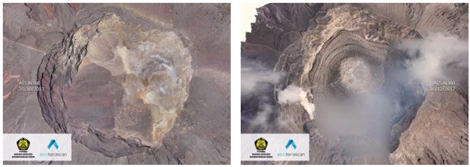
Visual of the crater of G. Agung using a drone (left: condition of the crater before it is filled with lava, October 20, 2017, right: condition of the crater after the lava filled the crater of a volume of 20 million m3 or 1/3 of the volume of the crater).
Potential hazards of secondary hazard in the form of mudslides can occur during heavy rains without being preceded by eruptions. The mudslide areas will follow the river valleys that originated on Mount Agung.
The results of modeling the potential distribution of volcanic ash in the air indicate that volcanic ash can be dispersed away from the summit of Mount Agung However, the potential disturbance of volcanic ash in the air depends on the speed and direction of the wind , so that the parties concerned will have to adapt the flight safety according to the actual state.
The potential danger of pyroclastic flows (hot clouds), at this moment is low because of the pressure accumulated in the body of Mount Agung which is not yet strong enough to catapult the lava dome from the surface of the crater.
Recommendations:
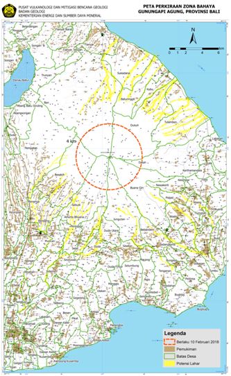
The communities around G. Agung and climbers / visitors / tourists must not ride or do any activity in the danger zone, in the G. Agung crater area and in all areas within 4 km radius. G. Agung. The estimated area risks are dynamic and continuously assessed and may change at any time based on the most recent observational data from G. Agung.
Thousands of people who have been forced to evacuate their homes on the Indonesian island of Bali because of the volcano can now return home, said Saturday, February 10 the authorities who lowered the alert level of Mount Agung.
Source : VSI, Strait Times.
Guagua Pichincha , Ecuador :
Mapping and thermal images in the area of the dome Cristal, volcano Guagua Pichincha
Summary:
On February 1, 2018, a group of technicians from the Institute of Geophysics (IG-EPN), Ecole Nationale Polytechnique, made a descent to the Cristal dome of Guagua Pichincha volcano (Figure 1) in order to carry out mapping work by drone, take direct measurements of the temperature of the volcano fumaroles and detect temperature anomalies with an infrared camera. The direct temperatures obtained in the fumarole fields showed temperatures between 87.0 ° C and 81.8 ° C, which are consistent with those recorded during the 2016 season. revealed also significant changes in the fumarole fields of the volcano. Direct observations and photographs taken with the drone did not reveal any changes in the known structures of the volcano.
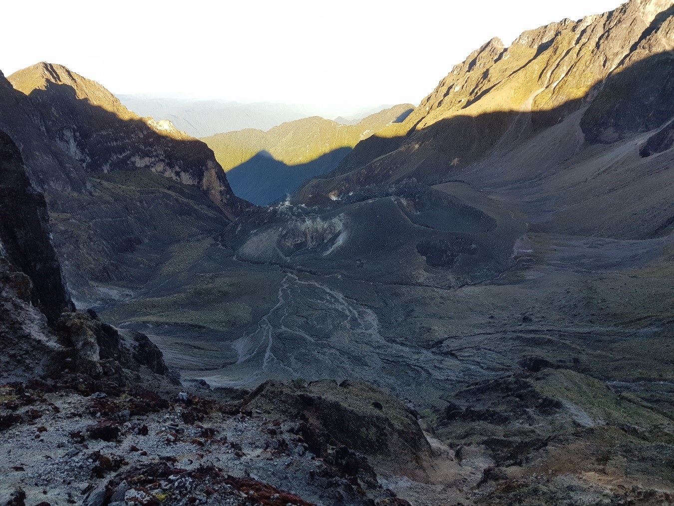
Figure 1. Crystal dome of the Guagua Pichincha volcano, seen from the top of Toaza (photo: S. Santamaría / IG-EPN).
1. Travel:
The group of technicians left at 05:00 from the Geophysical Institute towards Lloa, arriving at the Guagua Pichincha refuge at 06:40. The weather conditions were favorable for the work to be done, with a clear, cloudless sky in the amphitheater, it was decided to continue the mission (Figure 2). During the descent to the Crystal dome, a break was made at the edge of the Toaza to take thermal images with the infrared camera. The team finally arrived at the Cristal dome zone and its fumarolic fields at 09:00. After doing the measurement work with the thermocouple, we climbed to the top of the dome to begin aerial mapping with the drone. The team started the climb at 13:00.
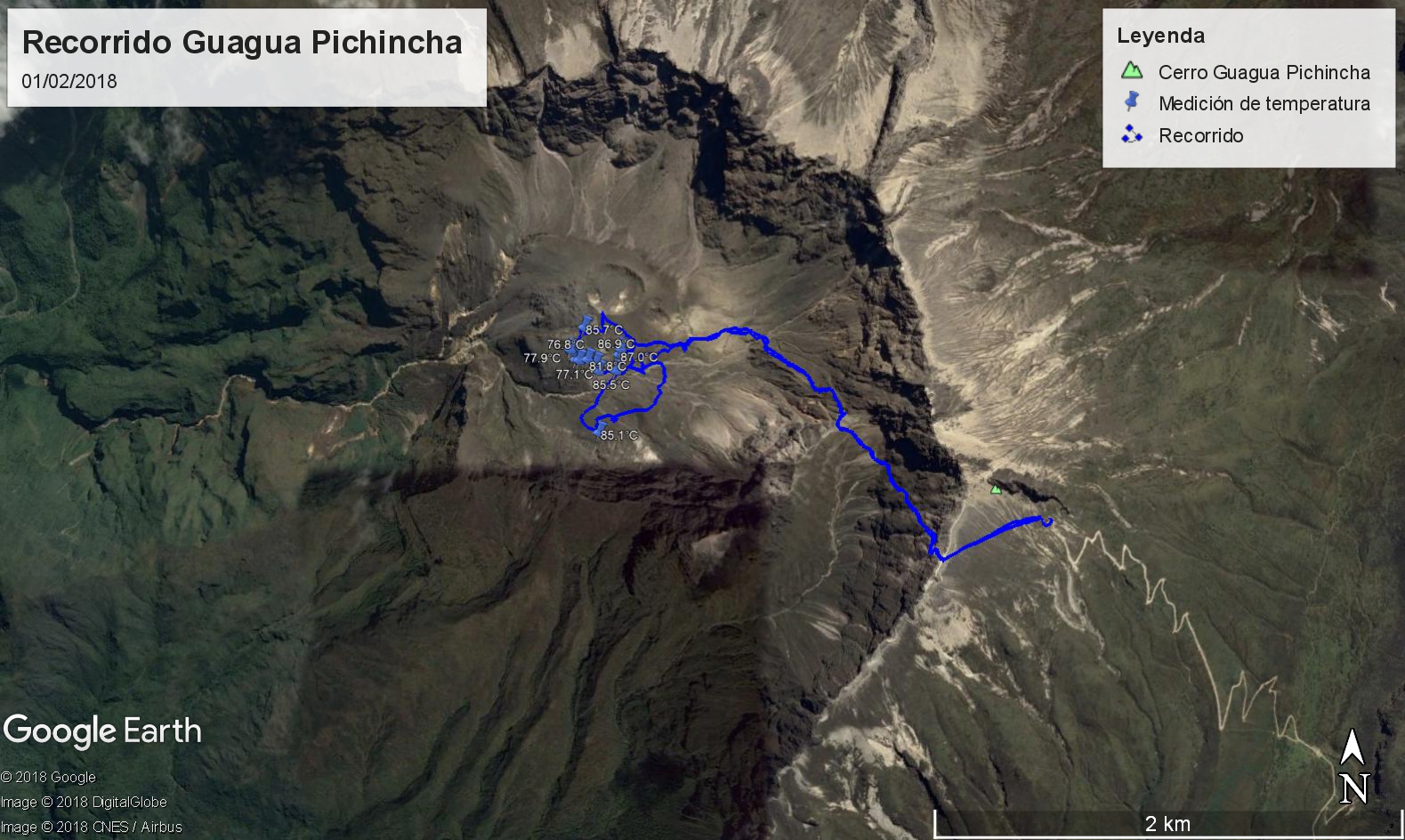
Figure 2. Route taken on February 1, 2018 in Guagua Pichincha volcano. The borrowed road is represented in blue. The figures correspond to the maximum temperature measured in each fumarole field.
2. Thermal monitoring.
2.1. Infrared images:
The work with infrared images was done in two stages. The first consisted in making panoramic images of the Crystal dome from the edge of the Toaza, and the second consisted in taking direct images of the « Muestro » and « La Locomotora » fumarole fields (Figure 3).
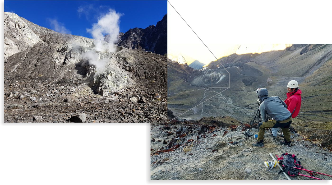
Figure 3. Thermal imaging of the fumarole fields of the Cristal dome (photos: S. Santamaría / IG-EPN).
Compared with previous campaigns, the distribution of thermal anomalies recorded on the Cristal dome did not show any significant changes (Figure 4); the most significant anomalies are those related to the fumarole fields of: Muestreo, Alineadas, Domo, Crater of 1981 and phreatic craters. At the north foot of Toaza, the fumaroles of La Locomotora do not change either. The apparent maximum temperature (TMA) was 42.8 ° C for Muestreo fumaroles, measured from Toaza. The TMA of the Muestreo and La Locomotora fumaroles measured in the vicinity were respectively 74.3 ° C and 61.3 ° C.
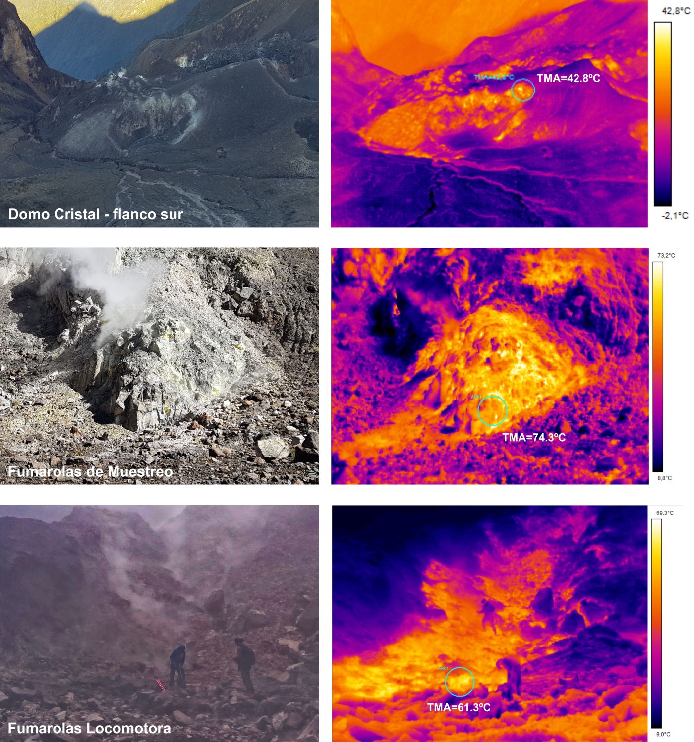
Figure 4. Thermal anomalies recorded during the campaign of 1 February 2018 (photos and images: S. Santamaría and E. Telenchana, analysis: Mr. F. Naranjo and S. Vallejo).
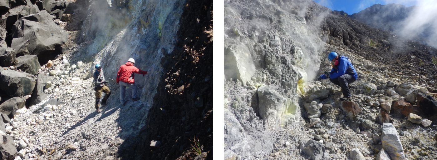
Figure 6. Direct temperature measurements in Domo fumaroles (left) and Muestreo (right) (photos: S. Santamaría and B. Bernard / IG-EPN).
The maximum measured temperature values are between 87.0 ° C and 81.8 ° C, which do not differ significantly from those taken during the campaign conducted in September 2016. These temperatures correspond approximately to the boiling point of water at the height of the Cristal dome (the boiling point is ~ 86.5 ° C at 4050 m altitude).
3. Visual monitoring and mapping.
While traveling in the Guagua Pichincha Amphitheater, no evidence was found to suggest morphological changes in the pre-existing structures of the Crystal Dome. Nor were there any variations in the geometry of the extruded dome during the 1999-2000 eruption.
To consolidate these observations and perform additional measurements, a drone flyover was used to capture photographic images to create a digital model of the high resolution Crystal dome. Unfortunately, during the flight, the weather conditions suddenly changed, blocking visibility from the ground, so the work was incomplete. However, the captured images were sufficient to corroborate the absence of significant changes in the geometry of the volcano.
Conclusions.
The results of thermal monitoring indicate that there have been no significant changes in volcano fumarole temperatures. Nor were there variations in the distribution of thermal abnormalities caused by smoking activity. No evidence has been found to suggest that the morphology of the Crystal Dome has changed in recent months. In this way, it can be suggested that there were no anomalies in the geothermal system of the volcano.
All the activities carried out allow a better understanding of the activity of the volcano and contribute to the reduction of the volcanic risk.
Source : IGEPN
Turrialba , Poas , Rincon de la Vieja , Costa Rica :
Daily report of the state of volcanoes Turrialba, Poás and Rincón de la Vieja; February 10, 2018, Updated at 11:00 o’clock.
Turrialba Volcano: The Turrialba volcano continues to emit ashes passively and continuously since last weekend. The seismic activity maintains a low level of activity of low amplitude Tremor bands and with some low frequency earthquakes. The present nebulosity does not allow a constant observation of the volcano.
The winds at the top of the volcano and the column of gas and ash move in a southerly, southwesterly, northwesterly, and northwesterly direction.
Ash falls have been reported on Moravia, Goicoechea, Curridabat, Coronado, Montes de Oca, Pavas, San Antonio de Belen and Alajuela. A smell of sulfur in Sabanilla, Goicoechea, Moravia, San Miguel, Santo Domingo de Heredia and Heredia is reported.

Poas Volcano: this volcano keeps a low release of gas, also has a low level of seismic activity, the winds carry the gas plume towards the West. The present nebulosity does not allow a constant observation of the volcano.
Rincón de la Vieja Volcano: activity over the past 24 hours.
In the last 24 hours, no eruption has been detected.
OVSICORI-UNA remains vigilant on the seismic and volcanic activity of the country.
Source : Ovsicori
Photo : RSN


No comment yet, add your voice below!