
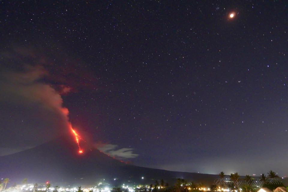
February 02 , 2018.
Mayon , Philippines :
MAYON VOLCANO BULLETIN 02 February 2018 08:00 A.M.
Sporadic and weak lava fountaining, continuous lava effusion and degassing from the summit crater characterized Mayon’s activity yesterday. Much of the activity produced low white to light-gray plumes, with the exception of four events that produced 750 to 1500 meter-tall gray ash plumes at 6:04 AM, 7:56 AM, 8:51 AM and 9:11 PM accompanied by loud booming sounds audible within 10 kilometers of the summit crater. Eleven (11) episodes of lava-collapse pyroclastic density current (PDC) events were visually observed between 8:51 AM yesterday and 2:01 AM this morning depositing along Miisi, Basud and Bonga Gullies within two kilometers of the summit crater. Throughout the night, quiet lava effusion fed lava flows and rockfall in the Miisi and Bonga-Buyuan channels and barrancos between these. The Miisi and Bonga-Buyuan lava flows have advanced to 3.2 kilometers and 4.0 kilometers, respectively, from the summit crater.
A total of three hundred thirty eight (338) volcanic earthquakes, most of which corresponded to sporadic and weak fountaining events, two (2) tremor events, eleven (11) distinct episodes of PDC generation from lava collapse and two (2) rockfall events were recorded by Mayon’s seismic monitoring network. Rockfall events were generated by the collapsing lava front and margins of the advancing lava flows on the Bonga and Miisi Gullies. Sulfur dioxide gas emission was measured at an average of 3,066 tonnes/day on 01 February 2018. Electronic tilt and continuous GPS measurements indicate a sustained swelling or inflation of the edifice since November and October 2017, consistent with pressurization by magmatic intrusion.
Alert Level 4 remains in effect over Mayon Volcano. The public is strongly advised to be vigilant and desist from entering the eight (8) kilometer-radius danger zone, and to be additionally vigilant against pyroclastic density currents, lahars and sediment-laden stream flows along channels draining the edifice. Civil aviation authorities must also advise pilots to avoid flying close to the volcano’s summit as ash from any sudden eruption can be hazardous to aircraft. DOST-PHIVOLCS maintains close monitoring of Mayon Volcano and any new development will be communicated to all concerned stakeholders.
Source : Phivolcs.
Photos : Raffy Tima, Jonathan Cellona.
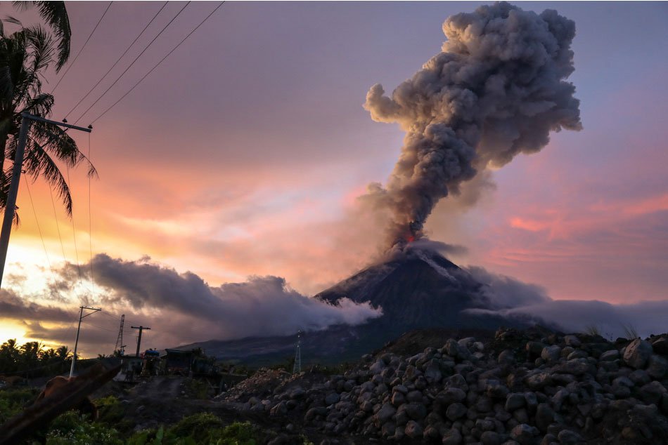
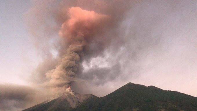
Fuego , Guatemala :
SPECIAL VULCANOLOGICAL BULLETIN 09-2018, Guatemala 01 February 2018, 09:45 hours (Local Time).
Vulcanian eruption of the Fuego volcano.
In the last few hours, the Fuego volcano has proposed a change in its eruptive pattern showing a vulcanian activity. The descent of pyroclastic flows mainly in the Seca (Santa Teresa), Trinidad, Las Lajas and Honda ravines is recorded. This generates explosions with ash columns reaching an altitude of about 7,000 meters (22,966 feet) moving more than 60 kilometers to the west, southwest and northeast of the volcano, causing falls of fine ashes on Santa Sofia, Morelia, El Porvenir, Finca Palo Verde, Sangre de Cristo, San Pedro Yepocapa, Panimache I and II, Ciudad Vieja, Antigua Guatemala, as well as west and southwest of Guatemala City .
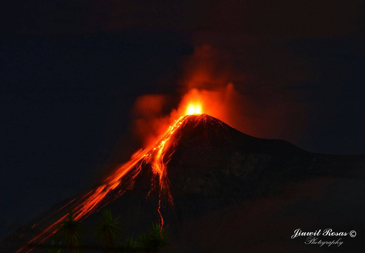
SPECIAL VULCANOLOGICAL BULLETIN 11-2018, Guatemala 1 February 2018, 4.30 pm (local time): ENDED ERUPTION.
The eruption of the Fuego volcano is over, with a duration of 20 hours, where lava flows were generated, a series of pyroclastic flows in the ravines Seca, Trinidad, Las Lajas and Honda, which accumulated volcanic material. The explosions that persist on the volcano, recorded by the seismic station FG3, are weak to moderate, expelling columns of ash at 4700 meters altitude. (15,419 feet) spreading 15 kilometers to the southwest.
There are still clouds of ash that will disappear in the coming hours. The incandescent source is not observed so the lava flows will disappear.
The seismic station FG3, registers a normal activity, the graph of the released energy (RSAM), decreased to normal ranges.
Source : Insivumeh.
Photos : Jiuwit Rosas , Jose Francisco Reyes Herrera.
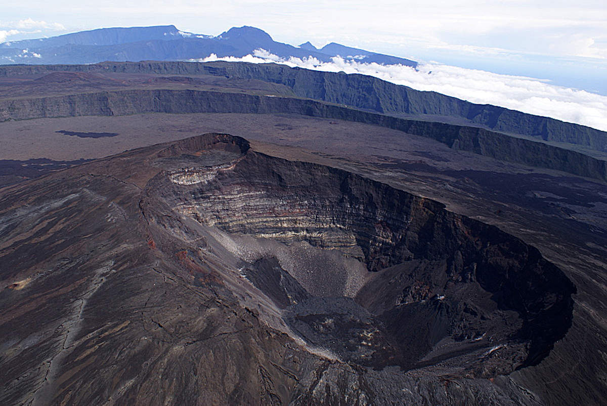
Piton de la Fournaise , La Réunion :
Monthly bulletin , Thursday, February 1, 2018.
Seismicity:
In January 2018, the OVPF recorded a total of:
• 16 superficial volcano-tectonic earthquakes (0 to 2 km deep) beneath the summit craters;
• 2 deep earthquakes (> 2 km deep);
• 115 collapses (in the crater Dolomieu, at the Enclos Fouqué ramparts and at the eruptive site of July / August 2017);
• 34 local earthquakes (under the island, Piton des Neiges side);
• 3 regional earthquakes (in the Indian Ocean area).
The volcano-tectonic activity under the Piton de la Fournaise massif thus remained weak in January 2018.
Deformation:
Throughout the month of January 2018, far-field GPS stations (at the base of the terminal cone and out of the Enclosure) continued to record a slow, continuous inflation, witnessing the pressurization of a deep source.
The main change comes from the stations around the summit craters which recorded during the first 18 days of January a high inflation (up to 1.2 cm of elongation of the summit zone in 2.5 weeks, Figure 1). This effect was also felt on the stations at the base of the terminal cone (up to 1.5 cm elongation) and in the far field (excluding Enclos ) but to a lesser extent (<0.5 cm elongation).
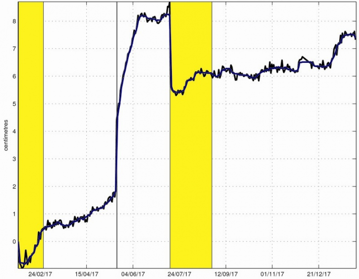
Figure 1: Illustration of the deformation over the last twelve months (the eruptions from January 31-February 27, 2017 and July 14-August 28, 2017 are shown in yellow and the injection of magma of May 17, 2017 is represented by a bar black). Here is shown a baseline (distance between two GPS receivers) crossing the Dolomieu crater from north to south (in black the raw data, in blue the data smoothed over a week). A rise is synonymous with elongation and therefore swelling of the volcano; conversely, a decrease is synonymous with contraction and therefore deflation of the volcano. (© OVPF / IPGP)
This high inflation observed at the level of the Piton de la Fournaise summit zone could be linked to a strong hydrothermal activity following the heavy rains of January (~ 1st fortnight of the month). The large influx of water into the superficial hydrothermal system and the rise in heat associated with a deep recharge (below sea level) have led to a thermal expansion of these hydrothermal fluids, at the origin of the inflation observed during the month (~ first half of the month).
Geochemistry of gases:
– Top emissions from the Piton de la Fournaise: persistence of low concentrations of H2S and sometimes SO2 in the air at the top of the volcano.
– CO2 concentrations in the soil at the level of the volcano deposit: intermediate concentrations. As with the deformations, the CO2 measurements were affected by the poor weather conditions of the first half of the month. The next steps will therefore be to follow.
Results :
All of these observations show for the month of January:
– a deep re-feeding of magma (below sea level) which is maintained;
– a pressurization of the superficial magmatic reservoir which remains weak;
– a significant hydrothermal activity in the first half of the month in connection with heavy rainfall.
Source : OVPF
Kadovar , Papua New Guinea :
VOLCANO INFORMATION BULLETIN – No. 18 02/02/2018 , Issue Date: 2nd February, 2018
Volcano: Kadovar, East Sepik. Papua New Guinea
Reporting Period: 31th January – 1st February 2018
Current Activity:
The eruption continues. The Main Crater produced moderate emissions of thick white vapor clouds, rising 100m before being blown to the SE. Steady continuous dull glow was observed for the last two nights.
A continuous white steam plume is rising from the SE Coastal Vent to 100 m above the island and is then blown to the SE.
The lava flow continues to grow – A distinct lobe has pushed out from the seaward nose of the flow, by about 20-30 m; this appears to be channeled by levees which have developed at the flows sides.
At 18:30 LT, 1st Feb, a collapse of the side of the lava flow facing Blup Blup was observed that resulted in a plume of grey ash and then vigorous steaming after the collapse which also glowed very brightly at night.
The main body of the flow has significantly bulged upwards, with a distinct ‘valley’ now visible between the bulge and the island’s flank. Thunder storms are active on the mainland, and this interferes with the identification of any noise from the island.
Ash plume: Mainly steam with minor ash is being emitted and is being blown to the SE. The plume extends for a few tens of kilometers.
Areas affected by ash fall: Downwind areas are affected by light haze.
Seismicity: High Frequency events were recorded during this period. Strong wind and waves are producing a very high background signal.
Other monitoring: The situation is also being monitored by various satellite techniques.
No significant SO2 emission was observed during this period, although rain and strong winds may be diluting and washing the gas from the atmosphere. No new deformation data is available.
Prognosis: Levels of SO2 being emitted have dropped recently and seismicity has lessened. Eruptive activity, however, continues at low levels. It has settled into a reasonable stable situation, but it is still possible for there to be variations in eruptive strength.
The continued quite rapid growth of the lava flow at the SE Coastal vent shows the eruption is still continuing. There is a slight possibility that small tsunami generation, but the situation is stabilizing.
Risk: High on Kadovar, on mainland and nearby islands – a small risk of tsunamis still exists
Source : RVO via John Kawatt.
Photo : BJG Productions.


No comment yet, add your voice below!