
January 23 , 2018.
Mayon , Philippines :
MAYON VOLCANO BULLETIN 23 January 2018 8:00 A.M.
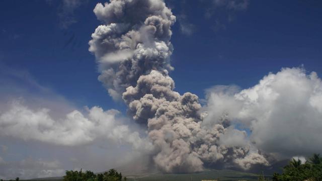
At 12:43 PM yesterday, a dense, five-kilometer tall eruption column was generated by a short-lived phreatomagmatic eruption at Mayon Volcano that lasted eight (8) minutes based on the seismic record. The event generated pyroclastic density currents or PDCs on gullies and barrancos heading the Miisi, Bonga, Buyuan, Basud, San Andres, Buang, Anoling and other minor rivers within four (4) kilometers of the summit vent, well within the Permanent Danger Zone (PDZ). Volcanic ash was blown west and fell on the Municipalities of Guinobatan, Camalig, Oas, Polangui and Iriga City. This was followed by a minor degassing event at 5:51 PM that generated a short, 500 meter-high ash plume. Between 9:37 PM and 5:25 AM the following morning, five (5) episodes of intense but sporadic lava fountaining from the summit crater lasting three (3) to thirty (30) minutes occurred. The lava fountains reached 500 meters to 700 meters high and generated ash plumes that reached 2.5 kilometers to 3 kilometers above the crater. The events fed lava flows on the Miisi and Bonga Gullies, sprayed near-vent lava spatter and fed incandescent rockfall on the summit area.
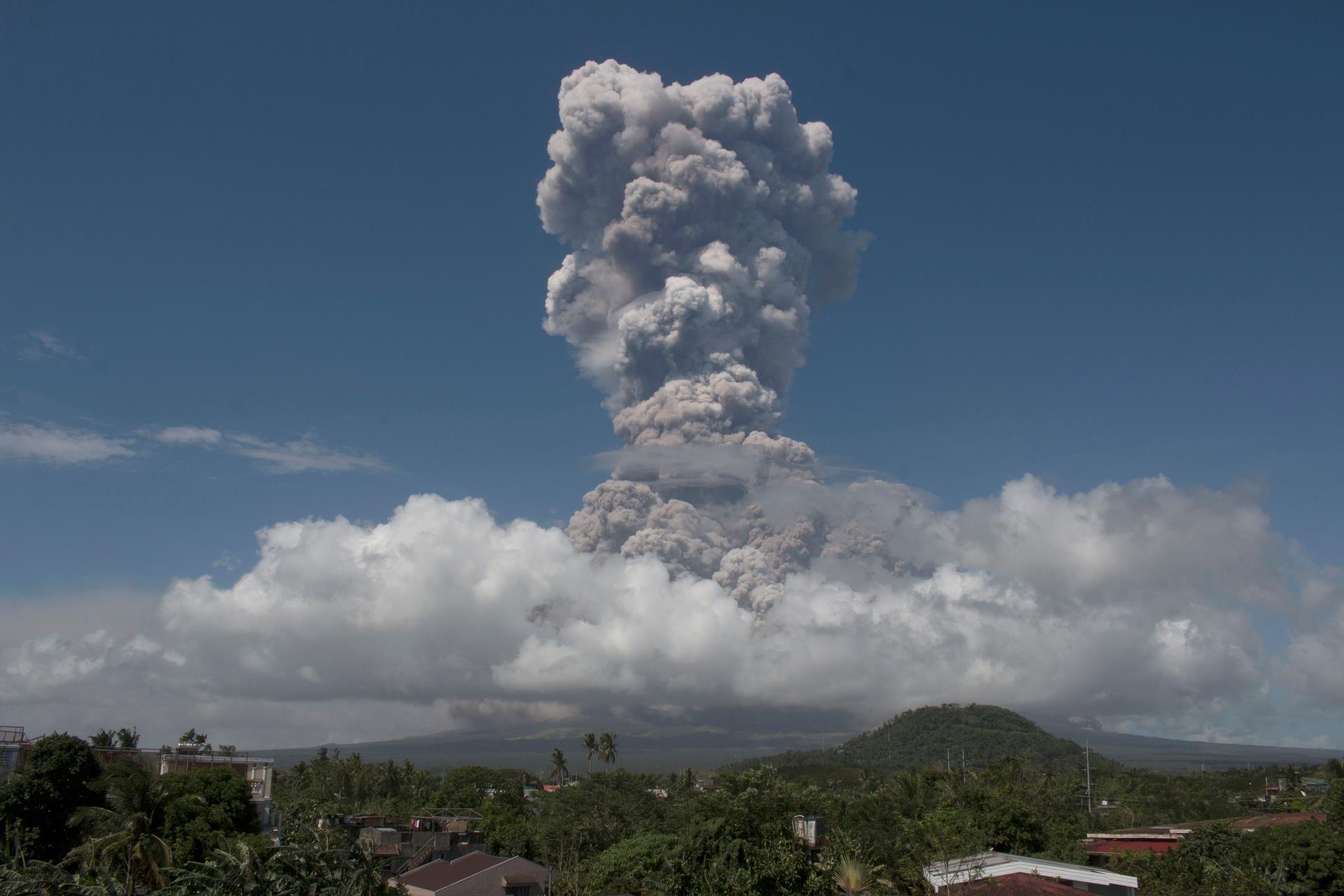
A total of two (2) explosion-type earthquakes corresponding to the vertical column eruptions, eighteen (18) tremor events, some corresponding to lava fountaining episodes, thirty five (35) rockfall events and (2) pyroclastic density currents or PDCs from lava collapse were recorded by Mayon’s seismic monitoring network. Rockfall events were generated by the collapsing lava front and margins of the advancing lava flow on the Miisi Gully and by shedding from the summit dome onto the Bonga Gully. Currently, the Miisi and Buyuan lava flows have advanced to three (3) kilometers and 200 meters, respectively, from the summit crater. Sulfur dioxide gas emission was measured at an average of 992 tonnes/day on 22 January 2018 prior to the phreatomagmatic event. Electronic tilt and continuous GPS measurements indicate a sustained swelling or inflation of the edifice since November and October 2017, consistent with pressurization by magmatic intrusion.
PHIVOLCS has raised the alert level to Alert Level 4 yesterday in effect over Mayon Volcano. The public is strongly advised to be vigilant and desist from entering the eight (8) kilometer-radius danger zone, and to be additionally vigilant against pyroclastic density currents, lahars and sediment-laden streamflows along channels draining the edifice. Civil aviation authorities must also advise pilots to avoid flying close to the volcano’s summit as ash from any sudden eruption can be hazardous to aircraft.
DOST-PHIVOLCS maintains close monitoring of Mayon Volcano and any new development will be communicated to all concerned stakeholders.
Source : Phivolcs :
Sabancaya , Peru :
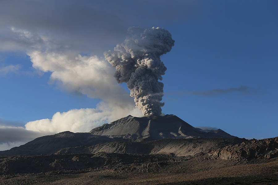
Explosive activity showed no change from the previous week, reaching a similar average of 57 explosions per day. Events associated with fluid movement (Long Period type) and ash emission (Type tremor) continue to predominate. Finally, earthquakes linked to the rise of the magma (Type Hybrids) maintain low levels in number and energy.
The eruptive columns of gas and ash remained similar to the previous week, reaching a maximum height of 3300 m above the crater. The dispersion of these materials occurred within a radius of about 50 km, mainly in the northwest direction.
Deformation monitoring at the GNSS station shows that the deformation curves maintain stable levels, without variations.
The volcanic gas (SO2) flux recorded on 19 January has a maximum value of 3410 tonnes / day, a value considered large.
Six thermal anomalies were recorded according to the MIROVA system, with values between 1 MW and 16 MW VRP (Irradiated Volcano Power).
In general, eruptive activity maintains moderate levels. No major changes are planned for the following days.
Source : IGP
Kadovar , Papua New Guinea :
Update from the RVO today (21st Jan 2018) suggests following observations for the Kadovar Volcano:
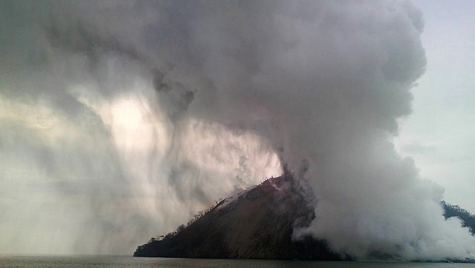
I. The dome of lava at the ‘SE Coastal Vent’ glows red at night and is slowly extending outwards into the sea. Due to the steepness of the volcano’s side this may collapse into the sea.
II. Estimates of islands deformations from satellite imagery data indicated that significant displacement of the SE side of volcano occurred at the time of the initial eruption event on 11th Jan 2018?
III. Photographic evidence of active faulting – wall movement suggests that the wall is potentially unstable and will collapse. I take it this may be referring to the crack extending from the SE vents down to the sea. We need to estimate the volume of material that could potentially fail into the sea which could generate a Tsunami if it where large enough.
IV. Continuing strong SO2 emissions, the presence of some high frequency earthquakes and slight increase in the frequency of those would suggest ongoing eruptive activity therefore – the situation is dynamic.
V. It is still possible, however that any new magma may stall before it reaches the surface.
VI. Due to the steepness of the island, landslides are possible, and together with the explosive nature of the magma, tsunamis may be generated. Fissures may allow water to interact with hot rocks or magma, leading to hydro volcanism (typically explosive activity).
Risk: On Kadovar Island – the whole island is affected by ash fall and SO2 gas – so risk is high
On the Mainland and other nearby Islands there is a risk of Tsunamis as cited in (iii) above.
Everybody must note that we are still on RED ALERT – the danger isn’t over yet.
Source : RVO , John Kawatt.
Kusatsu-Shirane , Japan :
One killed and 10 injured after Gunma’s Mount Kusatsu-Shirane erupts , Kyodo.
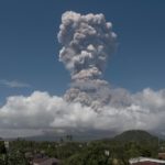
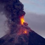
Mount Kusatsu-Shirane in the town of Kusatsu, Gunma Prefecture, erupted Tuesday morning, apparently triggering an avalanche that killed a member of Self-Defense Forces and injured at least 10 people, the Meteorological Agency said.
The mountain spewed black smoke after the eruption, which occurred at 9:59 a.m., according to the agency and the Kusatsu local government. The agency said it had detected a small volcanic tremor moments ahead of the eruption.
It warned of possible falling rocks within a 2-km radius of the mountain due to volcanic activity and raised the volcanic warning level from 1 to 3 on a scale of 5.
Level 3 bans visitors from entering the mountain and areas where it is deemed dangerous. It also urges the elderly, children and others in need of aid during evacuations to begin preparations to leave the area.
A Ground Self-Defense Force member who was training nearby was killed in the avalanche, with five others involved in the training injured, according to the GSDF.
A local fire department official said four people were thought to have been carried away by the avalanche, one of whom was buried.
The roof of a rest house at a ski resort in the area was also damaged by falling rocks, according to the official. About 80 skiers had been taking shelter there. A window on a cable car at the resort was also shattered, though the cause was not known. It was unclear if any of the skiers were among the injured.
Gunma Gov. Masaaki Osawa later requested the SDF to be dispatched to assist in rescue operations. In Tokyo, the central government set up a liaison office at the Prime Minister’s Office.
Mount Kusatsu-Shirane, at a height of 2,160 meters, is located near the border of Gunma and Nagano prefectures and is one of 50 volcanic mountains continuously monitored by the Meteorological Agency.
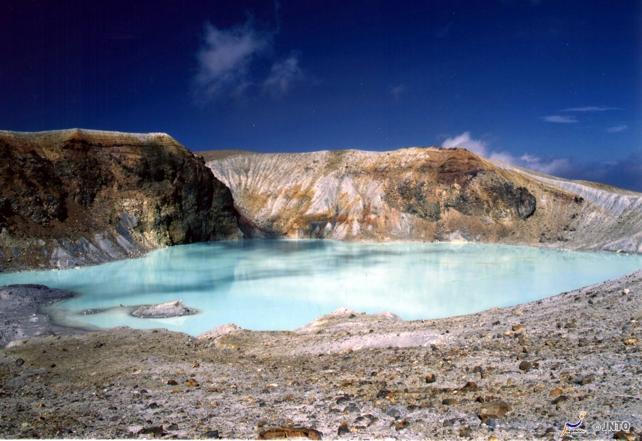
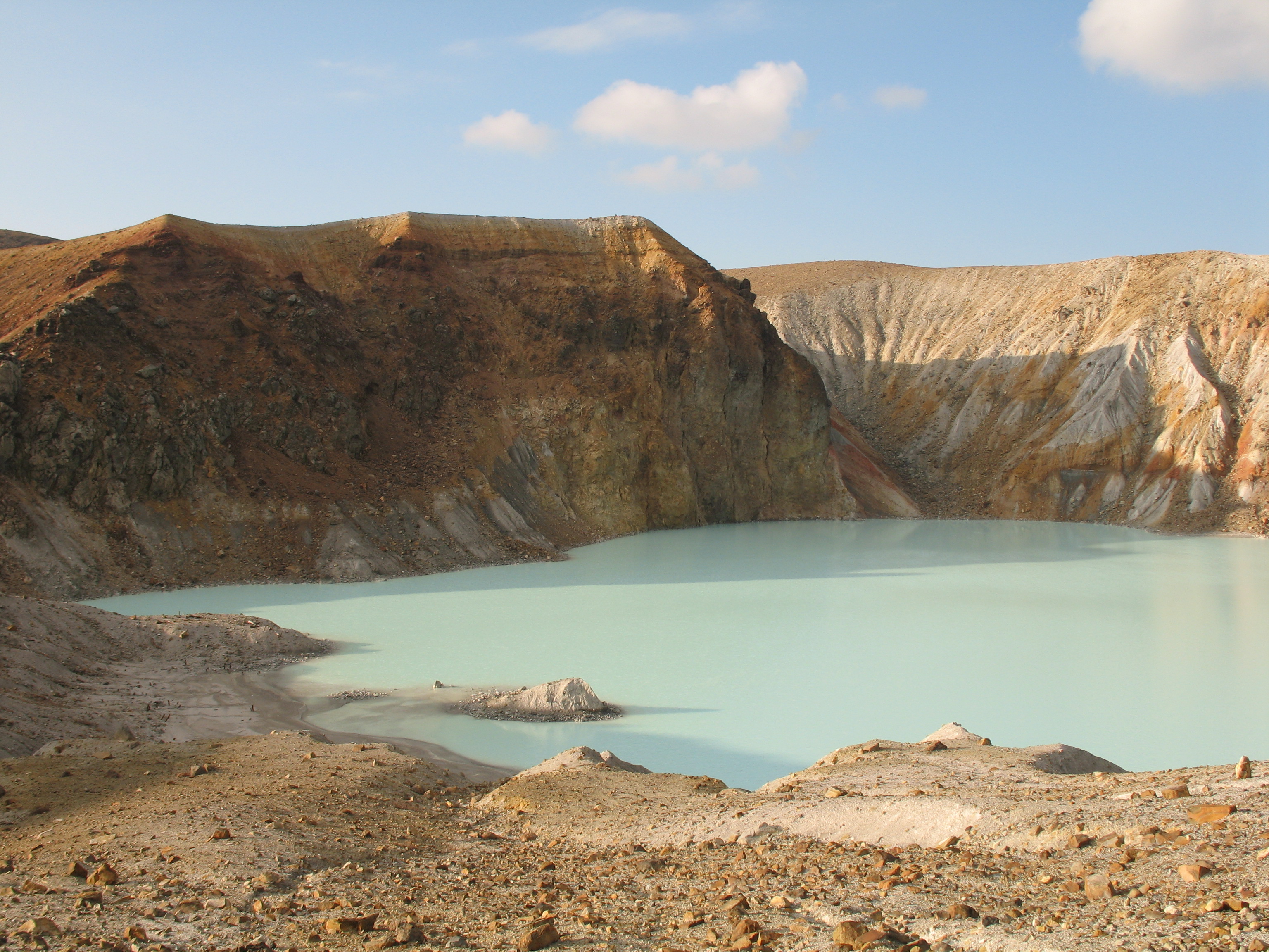
The summit of Kusatsu-Shiranesan volcano, located immediately north of Asama volcano, consists of a series of overlapping pyroclastic cones and three crater lakes. The andesitic-to-dacitic volcano was formed in three eruptive stages beginning in the early to mid Pleistocene. The Pleistocene Oshi pyroclastic flow produced extensive welded tuffs and non-welded pumice that covers much of the east, south and SW flanks. The latest eruptive stage began about 14,000 years ago. All historical eruptions have consisted of phreatic explosions from the acidic crater lakes or their margins. Fumaroles and hot springs that dot the flanks have strongly acidified many rivers draining from the volcano. The crater was the site of active sulfur mining for many years during the 19th and 20th centuries.
Source : Japantimes , GVP.
Photos : Summitpost , Haikugirl’s Japan.


No comment yet, add your voice below!