
January 22 , 2018.
Mayon , Philippines :
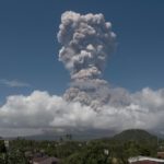
MAYON VOLCANO BULLETIN 22 January 2018 8:00 A.M.
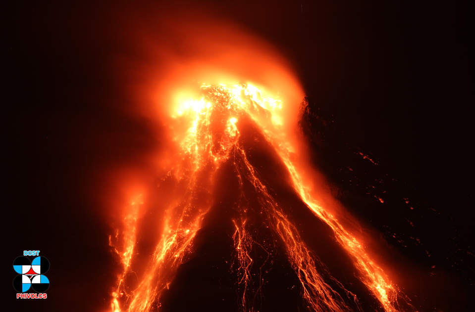
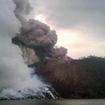
Lava eruption from the summit and lava collapse events characterized Mayon Volcano’s eruptive activity in the past 24 hours. Three (3) episodes of volcanic tremor, two of which corresponded to lava fountaining, sixty-four (64) rockfall events and one (1) pyroclastic density current or PDC were recorded by Mayon’s seismic monitoring network. Strombolian activity at 10:45 PM and 2:25 AM generated 500 meter- to 200 meter- high lava fountains, respectively, and ash plumes that rose 1,300 meters above the summit. The ash plumes were drifted southwest and ashfall was experienced in barangays of Oas and Guinobatan.
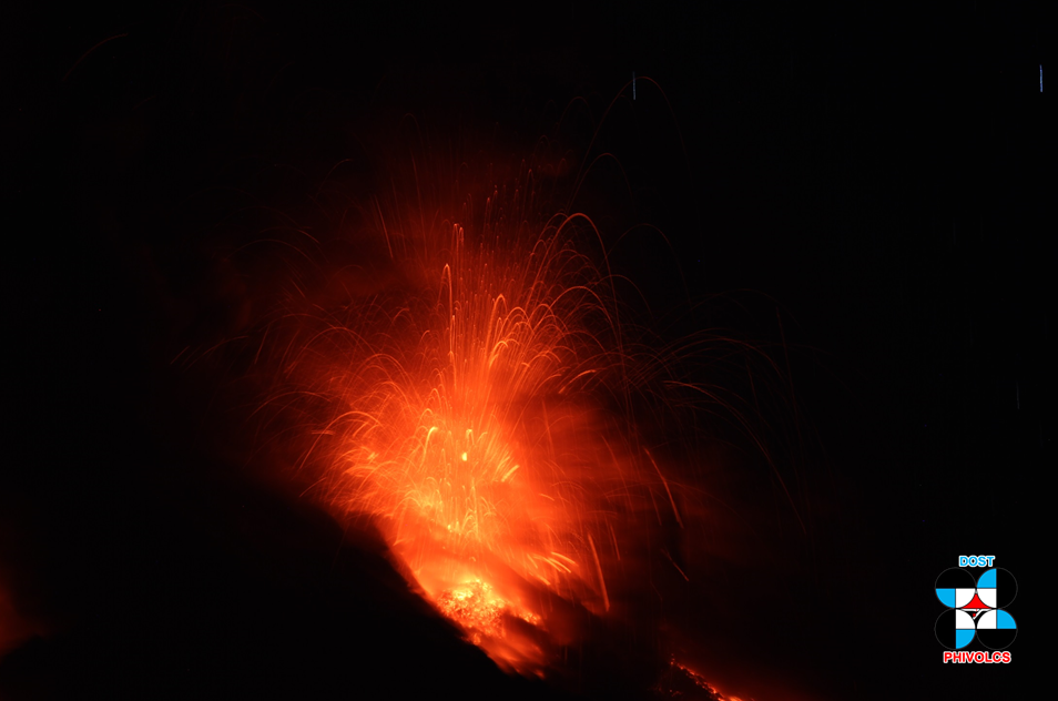
The lava fountains signified an increase in mass eruption rate, as lava was observed to be flowing more voluminously than before, feeding the advancing Miisi lava flow anew and feeding two new lava flows on the Bonga Gully and upper Buyuan watershed. Rockfall events were generated by the collapsing lava front and margins of the advancing lava flow and by shedding from the summit dome onto the Bonga Gully. Currently, the Miisi lava flow has advanced beyond three (3) kilometers from the summit crater well within the Permanent Danger Zone (PDZ). Weak ash clouds were lofted from the rockfall events as well as from the persistent disintegration of lava on the advancing front of the Miisi lava flow before drifting to the southwest. During night time, crater glow with incandescent rock flow along Miisi gully was observed. Sulfur dioxide gas emission was measured at an average of 689 tonnes/day on January 21, 2018. Electronic tilt measurements indicate a sustained swelling or inflation of the edifice since November 2017, consistent with pressurization by magmatic intrusion.
Alert Level 3 remains in effect over Mayon Volcano, which means that it is currently still in a relatively high level of unrest and hazardous eruption is still possible within weeks or even days. The public is strongly advised to be vigilant and desist from entering the six (6) kilometer-radius Permanent Danger Zone (PDZ) and the 7-km Extended Danger Zone (EDZ) on the southern flanks due to the danger of rockfalls, landslides and sudden explosions or dome collapse that may generate hazardous volcanic flows. Increased vigilance against pyroclastic density currents, lahars and sediment-laden streamflows along channels draining the edifice is also advised. Civil aviation authorities must also advise pilots to avoid flying close to the volcano’s summit as ash from any sudden eruption can be hazardous to aircraft. Based on the seasonal wind pattern, ash fall events may most likely occur on the southwest side of the volcano.
DOST-PHIVOLCS maintains close monitoring of Mayon Volcano and any new development will be communicated to all concerned stakeholders.
MAYON VOLCANO BULLETIN 22 January 2018 1:00 PM
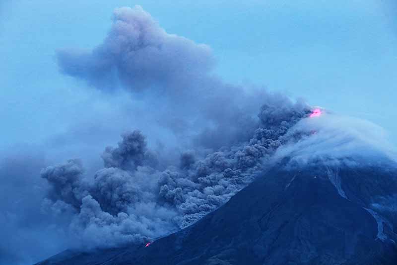
This serves as a notice for the raising of Mayon Volcano’s status from Alert Level 3 (increased tendency to hazardous eruption) to Alert Level 4 (hazardous eruption imminent).
Mayon Volcano in Albay Province has been exhibiting increased seismic unrest, lava fountaining and summit explosions.
In view thereof, DOST-PHIVOLCS is raising the Alert Level of Mayon Volcano from Alert 3 (increased tendency to hazardous eruption) to Alert Level 4 (hazardous eruption imminent). Because of this, the Danger Zone is extended to 8 kilometers radius from the summit vent. The public is strongly advised to be vigilant and desist from entering this danger zone. Civil aviation authorities must also advise pilots to avoid flying close to the volcano’s summit as ash from eruptions can be hazardous to aircraft. DOST-PHIVOLCS maintains close monitoring of Mayon Volcano and any new development will be communicated to all concerned stakeholders.
Source : Phivolcs.
Photo : Charism Sayat.
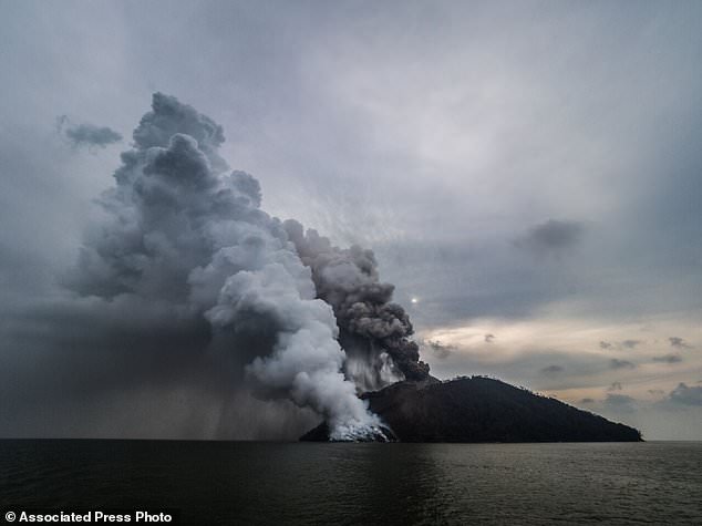
Kadovar , Papua New Guinea :
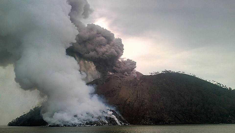
The island volcano in Papua New Guinea erupted again Sunday, sending plumes of steam and ash into the air. Thousands of people have been evacuated from the islands surrounding Kadovar Island off the north coast of the South Pacific since the eruption of the volcano on January 5th. Nearby flights were canceled due to ash plumes and ships were warned to stay away. island. Experts warned last week that seismic activity under the volcano meant that a major eruption could be imminent.
Papua New Guinea: eruption of the volcano on the island of Kadovar.
This volcano from Papua New Guinea erupted again on Sunday (21 January). He emitted smoke and ashes.
Thousands have had to be evacuated from nearby islands since the start of the volcanic eruption in early January. The volcano is located on the island of Kadovar, north of the main island of Papua New Guinea.
Flights to and from Papua New Guinea were canceled because visibility was limited due to ashes. Maritime traffic has been largely interrupted.
The experts also noted an increase in seismic activity in the immediate vicinity of the volcano, which may precede a major eruption.
The volcanological observatory of Rabaul, through its report, notes several discrete explosions, coming from the same vent, described as « moderate to strong ».
The main crater produces a gray / dark ash emission, rising 500 to 600 m above the summit. The observatory reports that the emission of sulfur dioxide emitted by the volcano has shown a strong signal in recent days. « Continuous emissions of sulfur dioxide, the presence of high frequency signals, the situation of the eruption indicate that the situation is dynamic, says the RVO.
The observatory indicates that the structure is unstable, following recent photographs showing significant movements on the South-East flank, as well as on the active fracture. The seismographs on Ruprup record discrete events at high frequency since Kadovar (2 seconds / 14/15 km). Their number has slightly increased. Some events are felt in Madang province.
The RVO has classified the Kadovar volcano as an » Holocene stratovolcano with andesitic dominant « .
Source : Los Angeles Times , De. Euronews.com , Loop PNG.
Photo : Beth Acknonero , Brenton-James Glover via AP .
Dukono , Indonesia :
VOLCANO OBSERVATORY NOTICE FOR AVIATION – VONA.
Issued: January 20 , 2018.
Volcano: Dukono (268010)
Current Aviation Colour Code: ORANGE
Previous Aviation Colour Code: orange
Source: Dukono Volcano Observatory
Notice Number: 2018DUK10
Volcano Location: N 01 deg 41 min 35 sec E 127 deg 53 min 38 sec
Area: North Maluku, Indonesia
Summit Elevation: 3933 FT (1229 M)
Volcanic Activity Summary:
Eruption with volcanic ash cloud at 08h55 UTC (17h55 local).
Volcanic Cloud Height:
Best estimate of ash-cloud top is around 5213 FT (1629 M) above sea level, may be higher than what can be observed clearly. Source of height data: ground observer.
Other Volcanic Cloud Information:
Ash cloud moving to Southeast.
Remarks:
Eruption and ash emission is continuing.
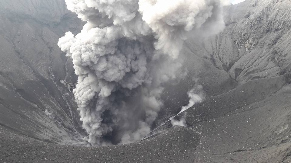
Activity Level of Level II (WASPADA). The Dukono (1229 m above sea level) has a continuous eruption.
Since yesterday until this morning visually the summit of the volcano can be observed clearly until the appearance of fog. The smoke rises from the main crater with a height of 200 to 300 meters above the summit, with low pressure, white / gray color and medium to thick intensity.
By the seismographs dated January 21, 2018, it was recorded:
A continuous tremor associated with ash emissions with an amplitude of 1-13 mm (dominant 2 mm).
2 earthquakes of eruption.
1 distant tectonic earthquake (TJ)
There was no rumbling heard at Dukono Post, 10 km north of the summit.
Recommendations:
Communities around G. Dukono and visitors / tourists should avoid activities, climbing and approaching the Malupang Warirang Crater within a radius of 2 km.
Source : VSI , Magma .
Photo : S Chermette / 80 jours voyages.
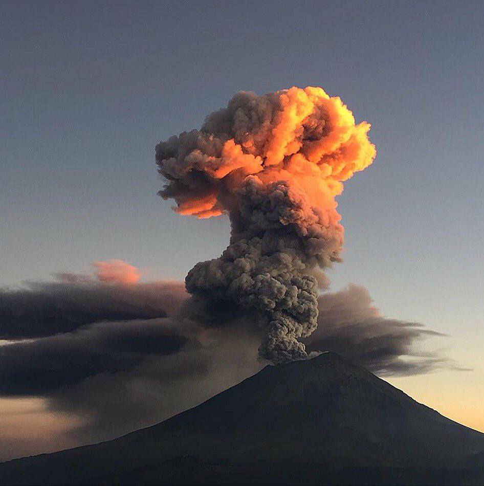
Popocatépetl , Mexico :
January 21, 11:00 am (January 21st, 5:00 pm GMT)
In the last 24 hours, through the monitoring systems of the Popocatepetl volcano, 67 low intensity exhalations accompanied by water vapor have been identified. In addition, 92 minutes of harmonic tremor of low amplitude and an explosion were recorded yesterday at 16h22.
During the night, there was an incandescent on the crater at the time of some exhalations.
At the time of this report, activity levels are stable.
CENAPRED urges not to approach the volcano and especially the crater, because of the risk of falling ballistic fragments and in case of heavy rains, to move away from the bottom of the ravines because of the risks of landslides and flows mud.
The volcanic warning light of the Popocatepetl volcano is located at Amarillo Phase 2
Source : Cenapred.


No comment yet, add your voice below!