
January 20 , 2018 .
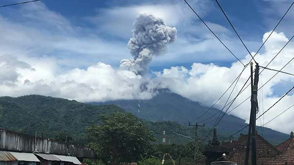
Agung , Indonesia :
VOLCANO OBSERVATORY NOTICE FOR AVIATION – VONA.
Issued: January 20 , 2018.
Volcano: Agung (264020)
Current Aviation Colour Code: ORANGE
Previous Aviation Colour Code: orange
Source: Agung Volcano Observatory
Notice Number: 2018AGU10
Volcano Location: S 08 deg 20 min 31 sec E 115 deg 30 min 29 sec
Area: Bali, Indonesia
Summit Elevation: 10054 FT (3142 M)
Volcanic Activity Summary:
Eruption with volcanic ash cloud at 11h20 UTC (19h20 local). Eruption and ash emission is not continuing. Bright glow from the crater was observed during the eruption. The eruption lasted for about 120 seconds.
Volcanic Cloud Height:
Best estimate of ash-cloud top is around 18054 FT (5642 M) above sea level, may be higher than what can be observed clearly. Source of height data: ground observer.
Other Volcanic Cloud Information:
Ash-cloud is moving East.
Remarks:
Seismic activity is characterized by high-frequency volcanic earthquakes.
On the basis of the results of the visual and instrumental data analysis and considering the potential threats of danger, on November 27, 2017 at 06:00, the status of G. Agung was raised from Level III (SIAGA) to Level IV (AWAS) . Since yesterday and until today visually the volcano is usually covered with fog. The emission of white fumes, low intensity and low pressure, reaches a height of about 100 m above the summit and tilts to the east. At night, the glow of the incandescent lava is not observed.
The records of the seismographs dated January 19, 2018 noted:
8 emission earthquakes
9 shallow volcanic earthquakes (VB)
8 deep volcanic earthquakes (VA)
1 tectonic earthquake (TL)
No low frequency earthquake (LF)
1 Earthquake of Eruption
A continuous tremor with an amplitude of 1 to 10 mm and a dominant value of 1 mm.
As of January 20, 2018 (00:00 to 18:00) it has been registered:
6 earthquake of emission
1 shallow volcanic earthquakes (VB)
6 deep volcanic earthquakes (VA)
No local tectonic earthquake (TL)
No low frequency earthquake (LF)
A continuous tremor with an amplitude of 1 to 10 mm and a dominant value of 1 mm.
Recommendations:
The communities around G. Agung and mountaineers / visitors / tourists should not climb, climb or do any activity in the danger zone around the G. Agung crater area and in all areas within 6 km from the crater of G. Agung. The estimated area risks are dynamic and continuously assessed and can be modified at any time based on the most recent observational data from G. Agung.
Level IV (AWAS) is only valid for a 6 km radius as mentioned above. Outside the activity area, everything can work like NORMAL and always SAFE.
Source : VSI , Magma .
Mayon , Philippines :
MAYON VOLCANO BULLETIN , 20 January 2018 , 8:00 A.M.
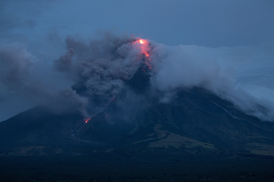
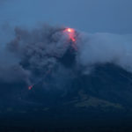
Quiet lava effusion from the new summit lava dome and lava collapse events characterized Mayon Volcano’s eruptive activity in the past 24 hours. Five (5) rockfall events were recorded by Mayon’s seismic monitoring network. Rockfall events were generated by the collapsing lava front and margins of the advancing lava flow on the Miisi Gully and by shedding from the summit dome onto the Bonga Gully. Currently, the Miisi lava flow has advanced to three (3) kilometers from the summit crater well within the Permanent Danger Zone (PDZ). Ash clouds were lofted from the rockfall events as well as from the persistent disintegration of lava on the advancing front of the Miisi lava flow before drifting to the southwest. Sulfur dioxide gas emission was measured at an average of 1131 tonnes/day on January 19, 2018. Electronic tilt measurements indicate a sustained swelling or inflation of the edifice since November 2017, consistent with pressurization by magmatic intrusion.
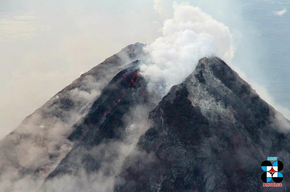
The summit dome installed in the crater notch – photo Phivolcs during the inspection flyover of 17.01.2018
Alert Level 3 remains in effect over Mayon Volcano, which means that it is currently still in a relatively high level of unrest and hazardous eruption is still possible within weeks or even days. The public is strongly advised to be vigilant and desist from entering the six (6) kilometer-radius Permanent Danger Zone (PDZ) and the 7-km Extended Danger Zone (EDZ) on the southern flanks due to the danger of rockfalls, landslides and sudden explosions or dome collapse that may generate hazardous volcanic flows. Increased vigilance against pyroclastic density currents, lahars and sediment-laden streamflows along channels draining the edifice is also advised.
Civil aviation authorities must also advise pilots to avoid flying close to the volcano’s summit as ash from any sudden eruption can be hazardous to aircraft. Based on the seasonal wind pattern, ash fall events may most likely occur on the southwest side of the volcano. DOST-PHIVOLCS maintains close monitoring of Mayon Volcano and any new development will be communicated to all concerned stakeholders.
Source : Phivolcs .
Nevados de chillan , Chile :
During this period, 5074 seismic events, of which eighty-four (84) were classified as volcano-tectonics (VT), processes related to the fracturing of a rigid material, with maximum local quantities (ML) of M 1.6 were recorded. The strongest earthquake was located 0.6 km northeast (NE) of the active crater at a depth of 2.1 km.
Similarly, four thousand nine hundred and ninety (4990) earthquakes associated with fluid dynamics within the volcano, of which 3385 were considered as long-period (LP) events, with maximum values reduced displacement (DRC) of 75 cm2 were recorded. They were located 0.8 km north-west (NW) of the active crater at a depth of 0.7 km. Finally 1605 tremor events (TR) were also recorded, with a maximum reduced displacement value of 369.2 cm2.
Between January 1 and January 15, pulsatile explosive behavior was recorded, with a total of 1027 explosions, associated mainly with magmatic gases almost without addition of ash and / or recording of acoustic signals picked up by the network of microphones installed on the slopes of the volcano, in continuation with the explosive phase that this volcano presents since the beginning of 2016.
The images obtained through the cameras installed near the volcanic complex, showed mainly gas emissions associated with the explosions, coming from the craters currently active with column heights lower than 1000 m compared to the level of the crater. During the nights, the cameras sporadically recorded incandescences associated with certain explosions and / or increases in gas emissions from the active crater.
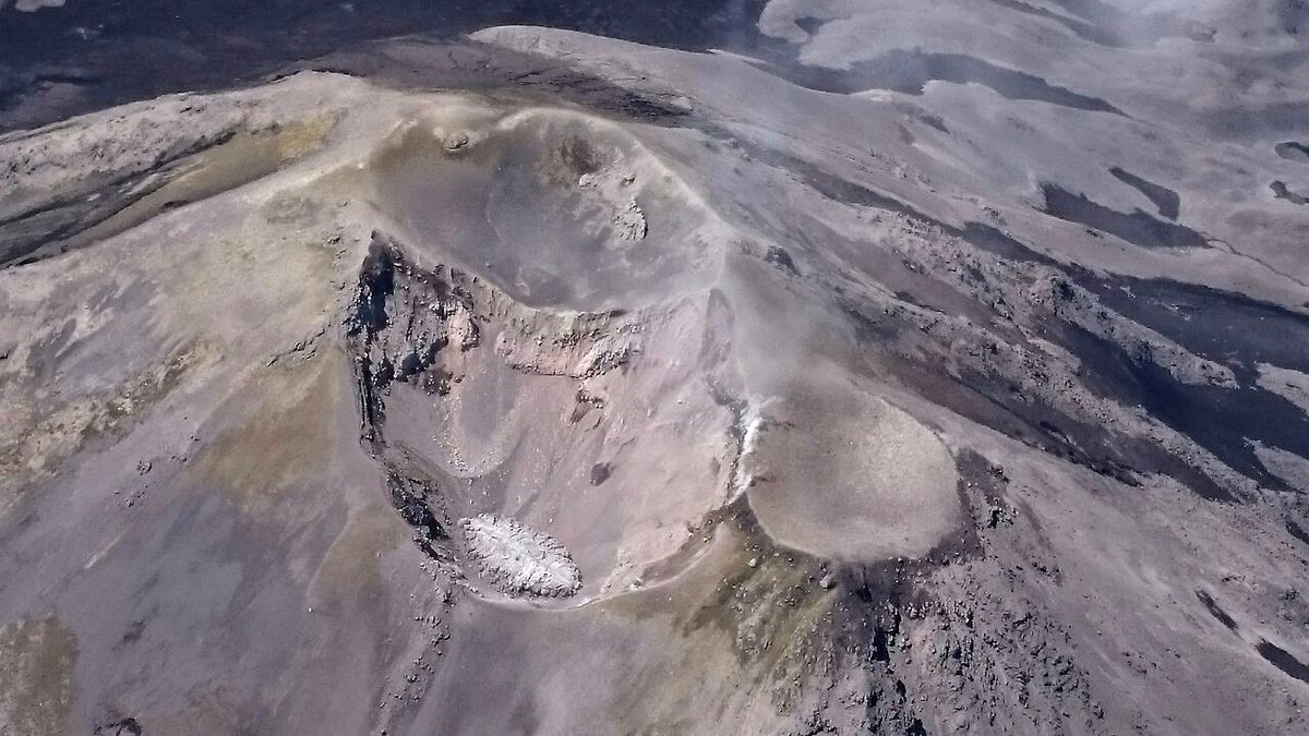
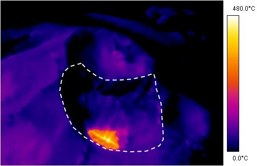
In order to better follow the growth of the dome located in the active crater of the Nevados volcanic complex of Chillan, the SERNAGEOMIN with the collaboration of the ONEMI of the Biobio region, made two consecutive overflights on the 9th and 12th of January where measurements of temperatures were taken, which gave values of 480 to 500 ° C on the surface of the dome, mainly
in the crack through which the reported explosions originate.
In addition, on the basis of the images obtained by these overflights, as well as by the satellite images, it was possible to determine a dome growth rate, with an average estimate of 1360 m3 / day (0.015 m3 / s). which is a low rate for such phenomena. The estimated total volume is about 37,000 m3. It is emphasized that the dome is nested in the active crater and is always below the edge level of it.
In the aforementioned overflights on January 9 and 12, images were also recorded with infrared (IR) cameras, determining average gas flow rates S02, 250 and 617 t / d, respectively. SO2 emissions fluctuated between 100 and 920 t / d, during a period of greater degassing. A gradual increase in S02 emissions has been observed, with regard to images taken from 2015 to date. However, these values are considered low for this volcano, which is consistent with the presence of the dome whose nature implies a high degree of degassing.
From the geodetic data, a very weak deformation with a deflationary effect was observed, due to very subtle changes in volume inside the volcano which occurred during the last months, depending on the activity. recorded, from 2016 to date, suggesting a small volume body set up in shallow layers.
No sulfur dioxide (SO 2) emissions in the volcanic complex sector have been reported, according to data published by the ozone monitoring instrument, Sulfur Dioxide Group (IMO) (http: // so2. gsfc.nasa.gov/) and the National Information and Satellite Data Service on the Environment (NESDIS).
A very low intensity thermal alert, less than 1 MW, was reported in the area associated with the volcanic complex on 1 January, according to the data processed by the Infrared Mean Observation of Volcanic Activity (MIROVA). These data are also consistent with the presence of the dome whose solid shell isolates the high temperatures inside, decreasing the area of the thermal anomaly to be detected.
The explosive activity associated with the growth of the lava dome in the active crater continues (ascending magma releases its gases by decompression, producing the explosions mentioned above). The extrusion phase continues, and is reflected in the stability of the released seismic energy. As a result, 90% of the dome is destroyed explosively, a phenomenon that could last a few months, depending on the volume of magma that rises from the depths. In this context, the destruction of the dome may be associated with vulcanian-type explosions stronger than those currently recorded which will depend on the volume and pressure of the underlying magma body, with the possibility of generating pyroclastic flows in the volcanic zone , as well as ash falls in areas near the volcano.
For all this, the level of volcanic alert is maintained at Yellow level: changes in the behavior of volcanic activity.
It is recommended to apply access restrictions to a 4 km zone around active craters.
Source : Sernageomin
Ebeko , Kamchatka :
50.69 N, 156.01 E;
Elevation 3792 ft (1156 m)
Aviation Colour Code is ORANGE
A moderate gas-steam with some amount of ash activity of the volcano continues. Ash explosions up to 16,400 ft (5 km) a.s.l. could occur at any time. Ongoing activity could affect low-flying aircraft and airport of Severo-Kurilsk.
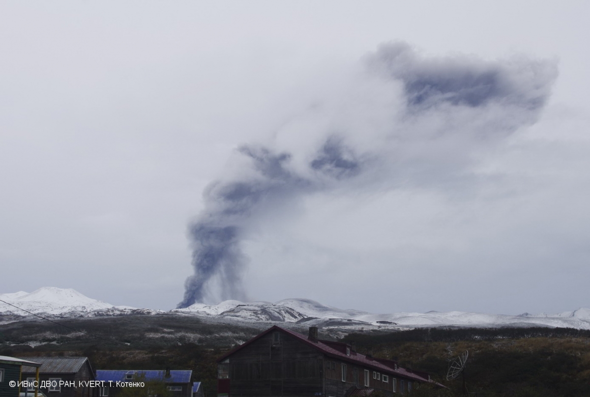
A moderate explosive activity of the volcano continues. According to visual data by volcanologists from Severo-Kurilsk, explosions sent ash up to 3.1 km a.s.l. on 11-12, 14-16 and 18 January, weak ashfalls were noting at Severo-Kurilsk on 15-16 and 18 January. Satellite data by KVERT showed the volcano was quiet or obscured by clouds.
Source : Kvert .
Photo : T. Kotenko, IVS FEB RAS, KVERT , 17/10/2017 .


No comment yet, add your voice below!