March 4, 2024. EN. Ecuador / Galapagos Islands : Fernandina , Iceland : Reykjanes Peninsula , La Réunion : Piton de la Fournaise , Indonesia : Ili Lewotolok , Chile : Descabezado Grande .

March 04 , 2024.


Ecuador / Galapagos Islands , Fernandina :

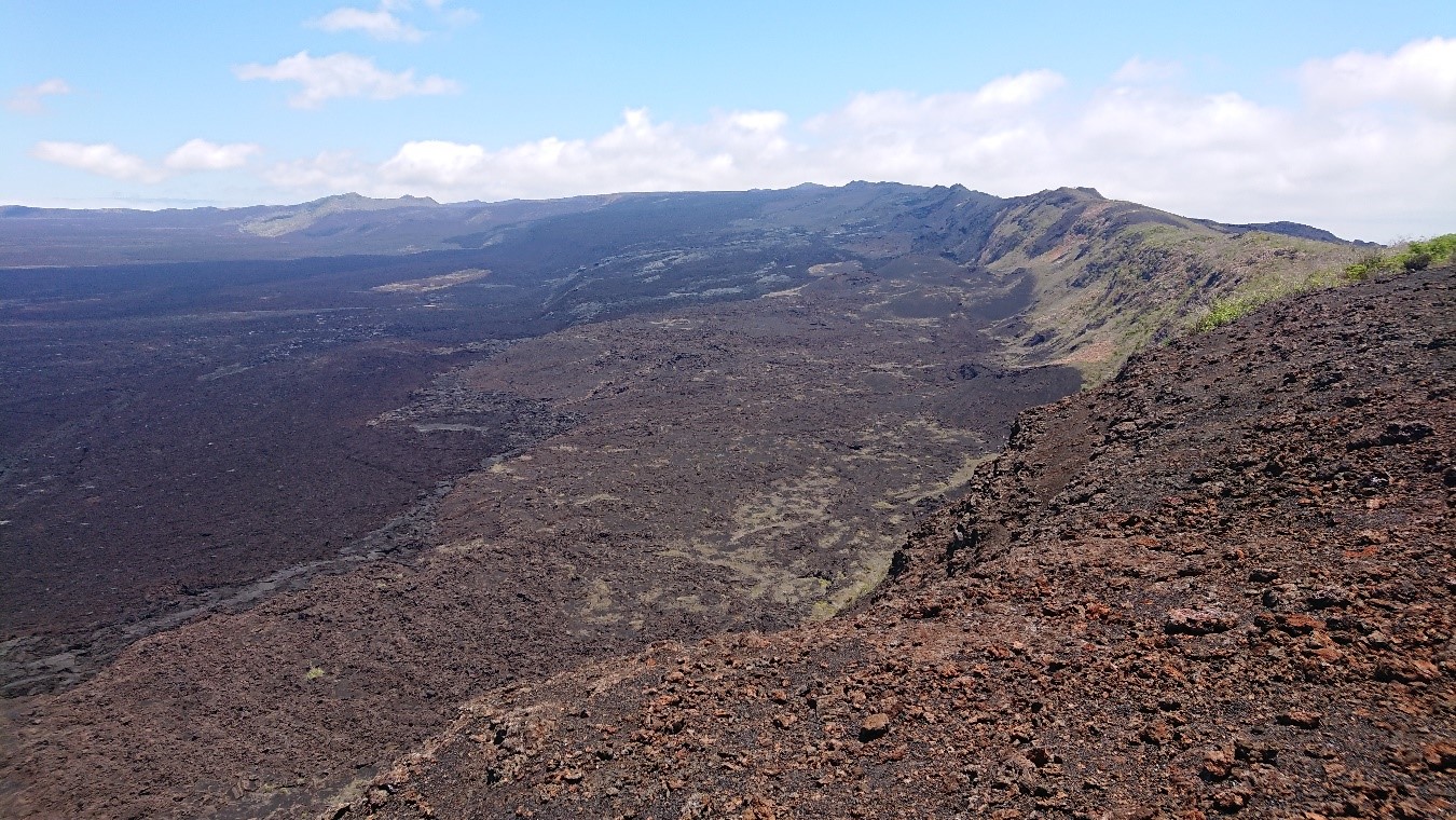
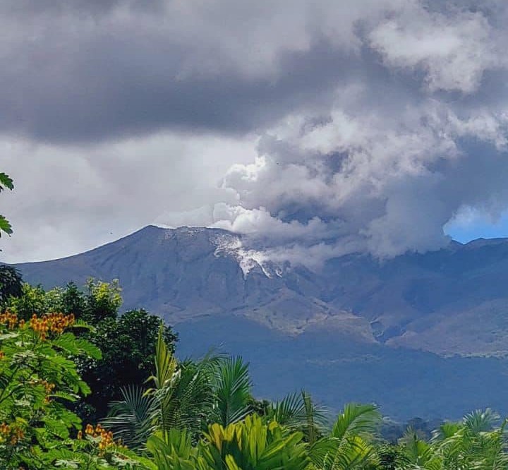
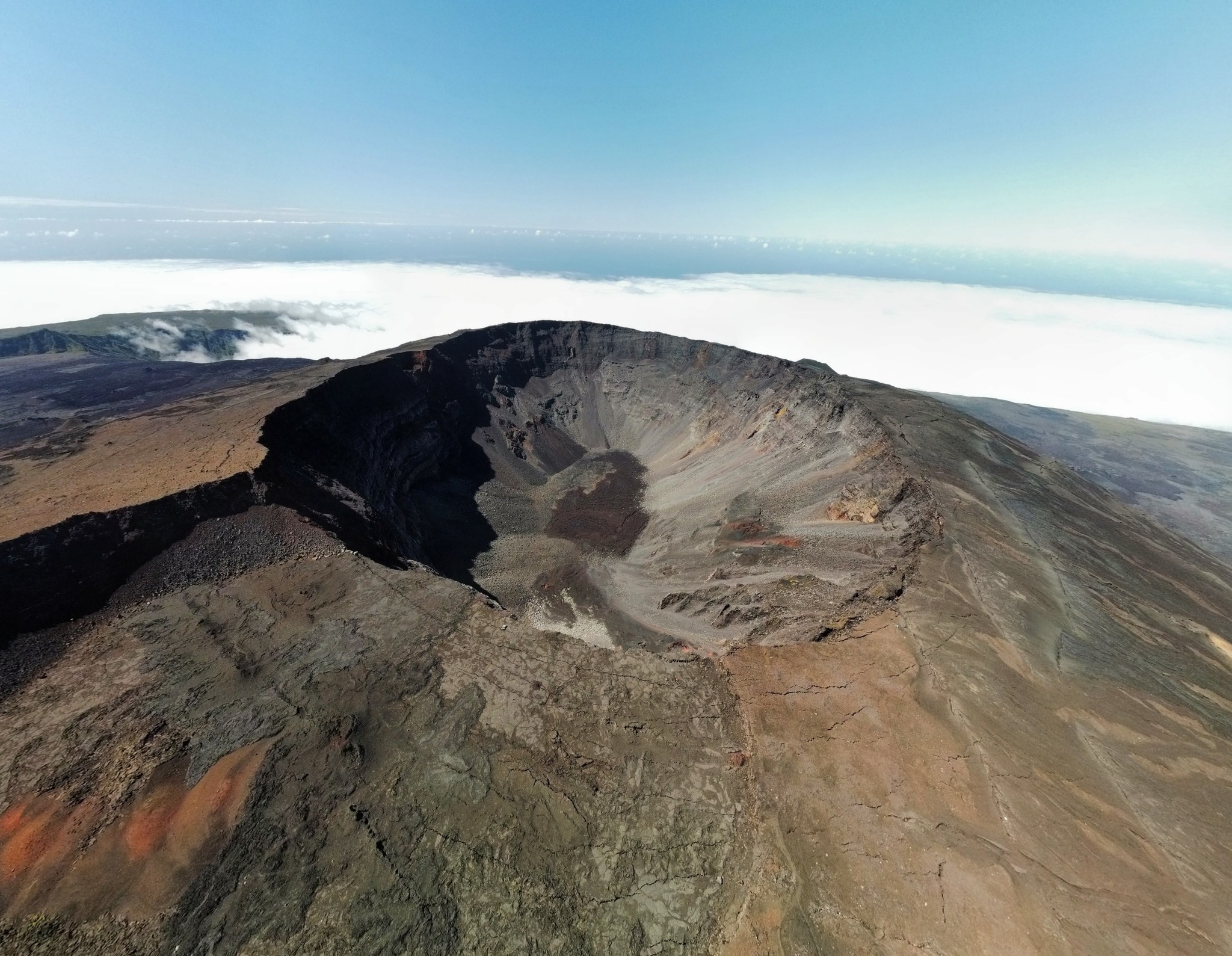
Special Volcanic Report – Fernandina. The Fernandina (La Cumbre) volcano, Galapagos Islands, begins a new eruptive period.

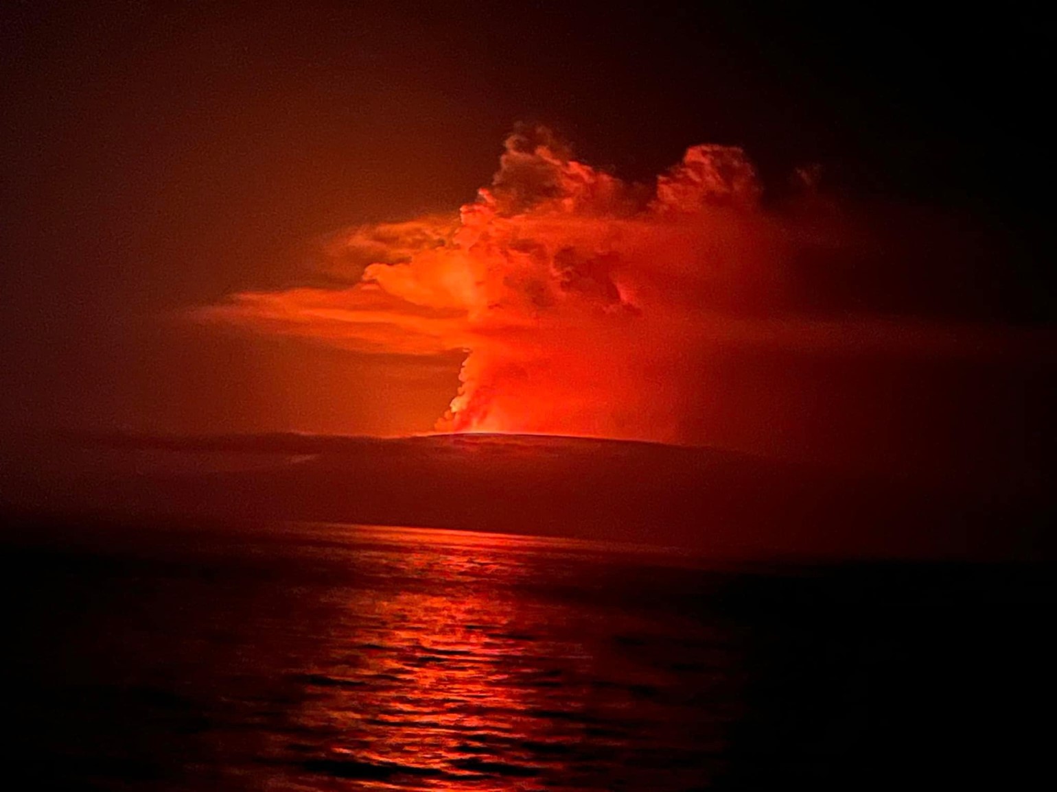
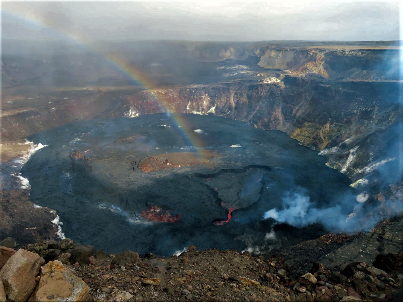
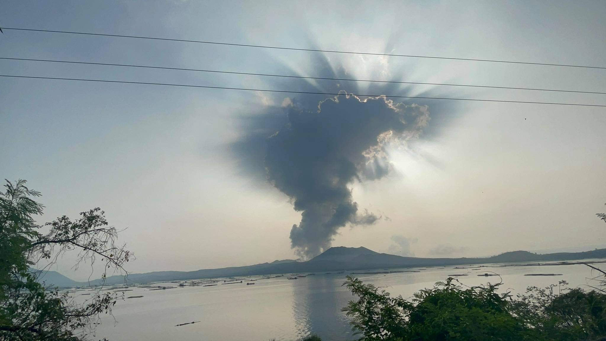
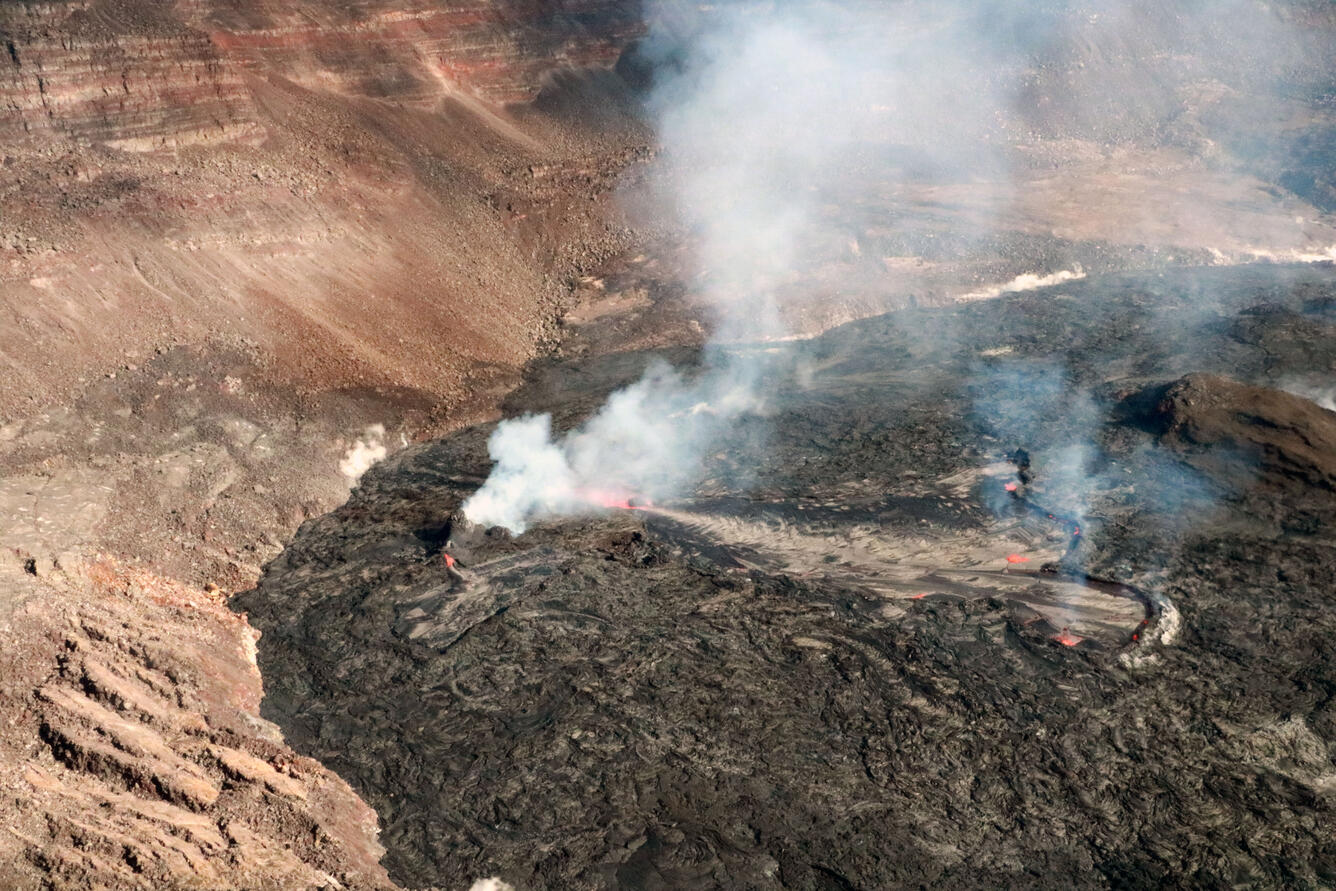
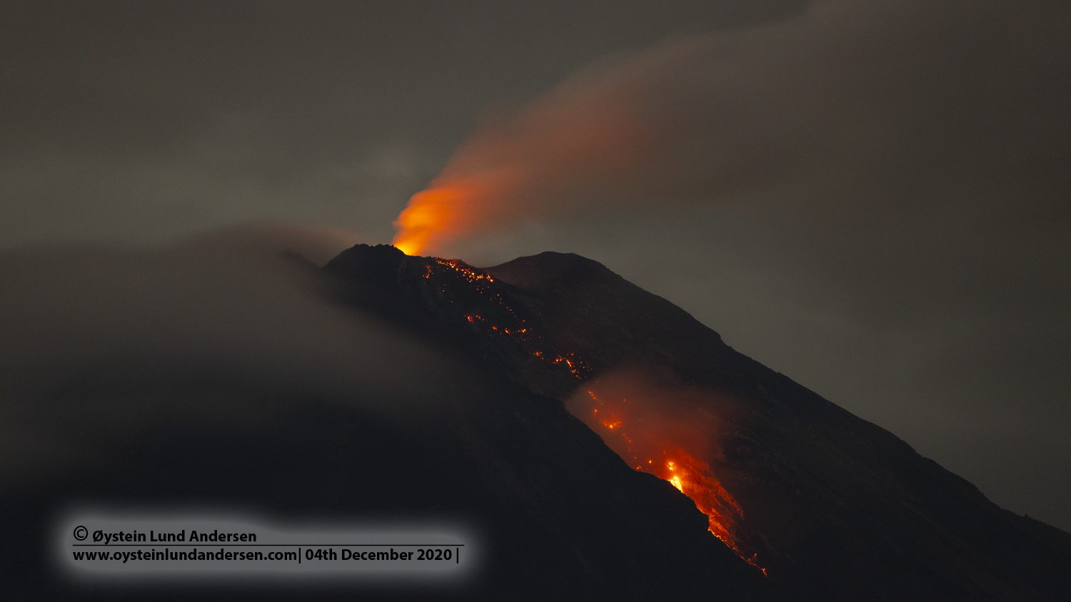
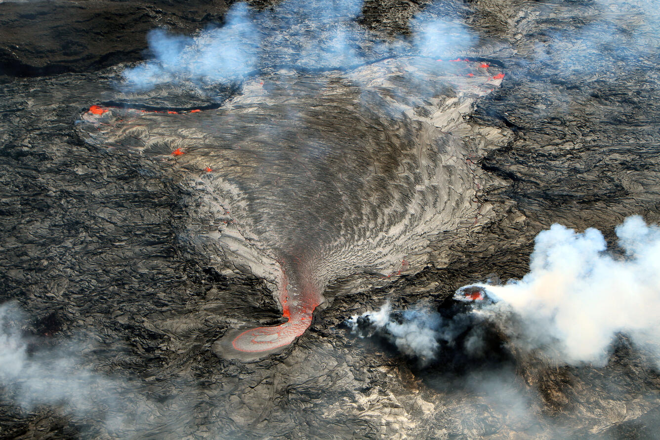
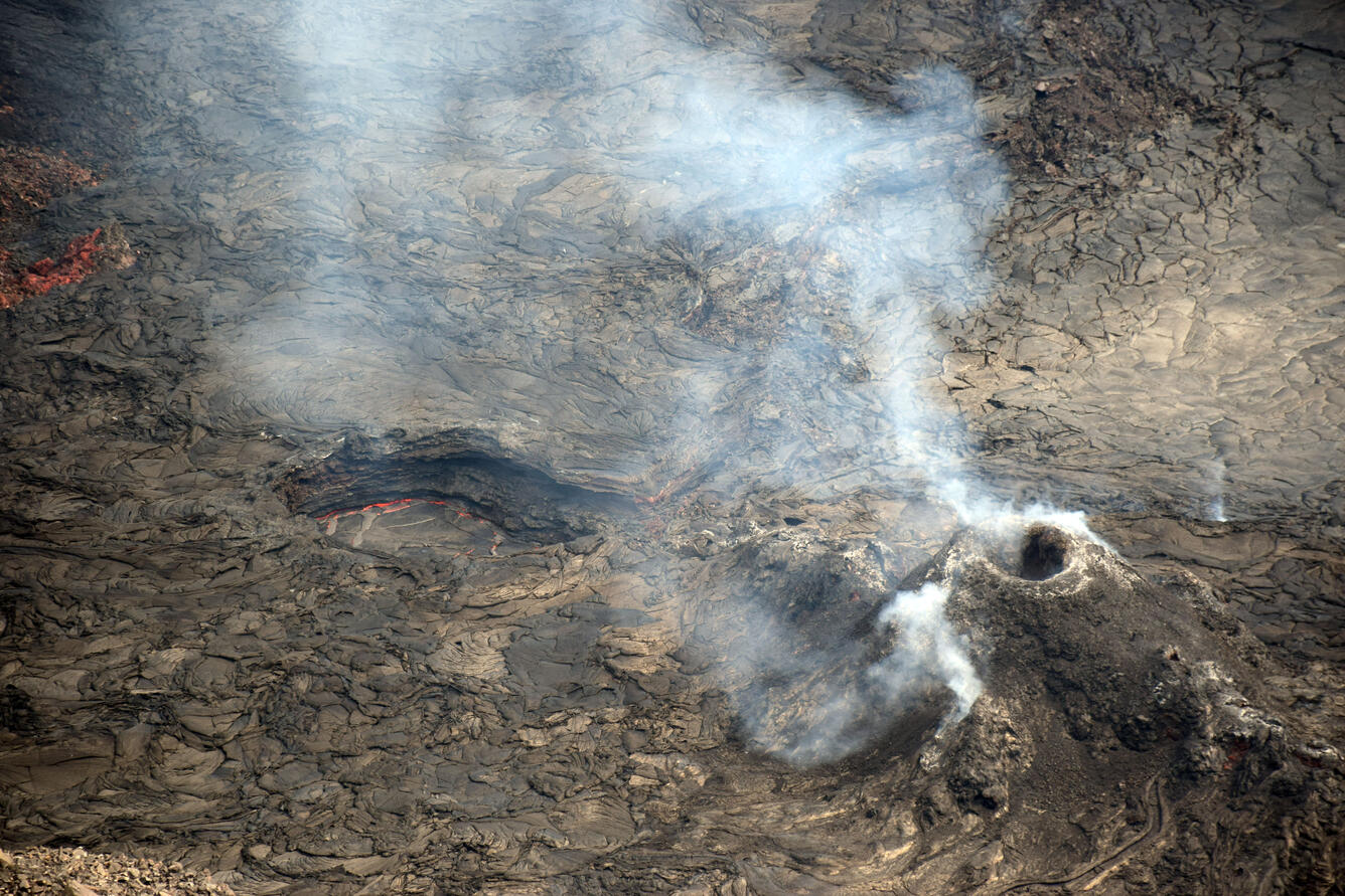
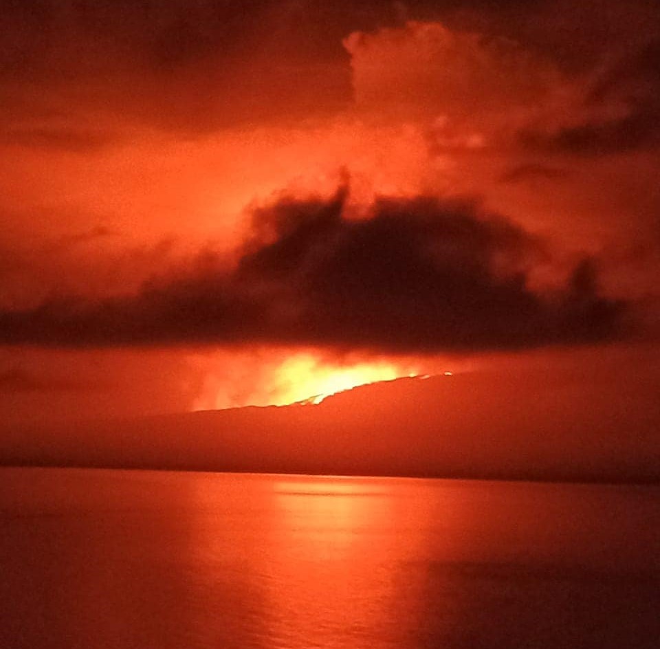
Figure 1. Start of the eruption of the Fernandina volcano (Galapagos). In the image, the gas emission is observed at a height between 2 and 3 km above the summit level towards the West. The incandescence corresponds to lava flows. Photograph retrieved from Facebook authors Doménica Guerrero and Jeff O’Marley Herrera. Published by Radio Santa Cruz.

summary
On Saturday March 2, 2024 at 11:50 p.m. (Galapagos time), the Fernandina volcano (La Cumbre) began a new eruptive process, 4 years after its last eruption (January 2020). Gas emissions and thermal anomalies were detected using the GOES-16 and VIIRS satellite systems. Images shared on social networks confirm the eruption through a circumferential crack located in the upper part of the southeastern flank. In the hours that followed, the gas cloud, without much ash, moved under the influence of the wind towards the West, the North-North-West and the South-South-East. It is important to note that Fernandina Island does not have any human settlements and therefore there is no risk to people. The duration of the eruption cannot be accurately predicted, nor whether it will reach the seashore, but based on volcano deformation data accumulated since the last eruptive period, it is likely that the current eruption will be larger than those observed in 2017, 2018 and 2020. The Institute of Geophysics continues to monitor the phenomenon and will notify in the event of significant changes.

Background
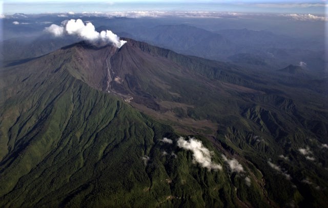
The Fernandina volcano (La Cumbre) presented its last eruptive process on January 12, 2020, which lasted approximately 9 hours and was characterized by the opening of a fissure located under the eastern edge of the caldera, where flows of lava were emitted towards the eastern flank. (IGEPN, 2020a). Additionally, a gas cloud was generated, reaching a maximum height of 3.5 km above sea level. In the weeks following the eruption, an increase in seismicity associated with ground deformation was recorded (IGEPN Report, 2020b; IGEPN, 2021). With between 28 and 30 recorded eruptions since 1800, Fernandina Volcano has the highest eruption recurrence rate in the Galapagos Islands.

Ash and gas clouds:
Starting at 11:50 p.m. TL (Galapagos time) on March 2, the geostationary satellite GOES-16 recorded gas emission about 2-3 km above summit level with very low ash content. The broadcast was most intense until around 04:00 TL before fading. The gas cloud moved towards the West, the North-North-West and the South-South-East without going beyond populated areas.

Lava flows
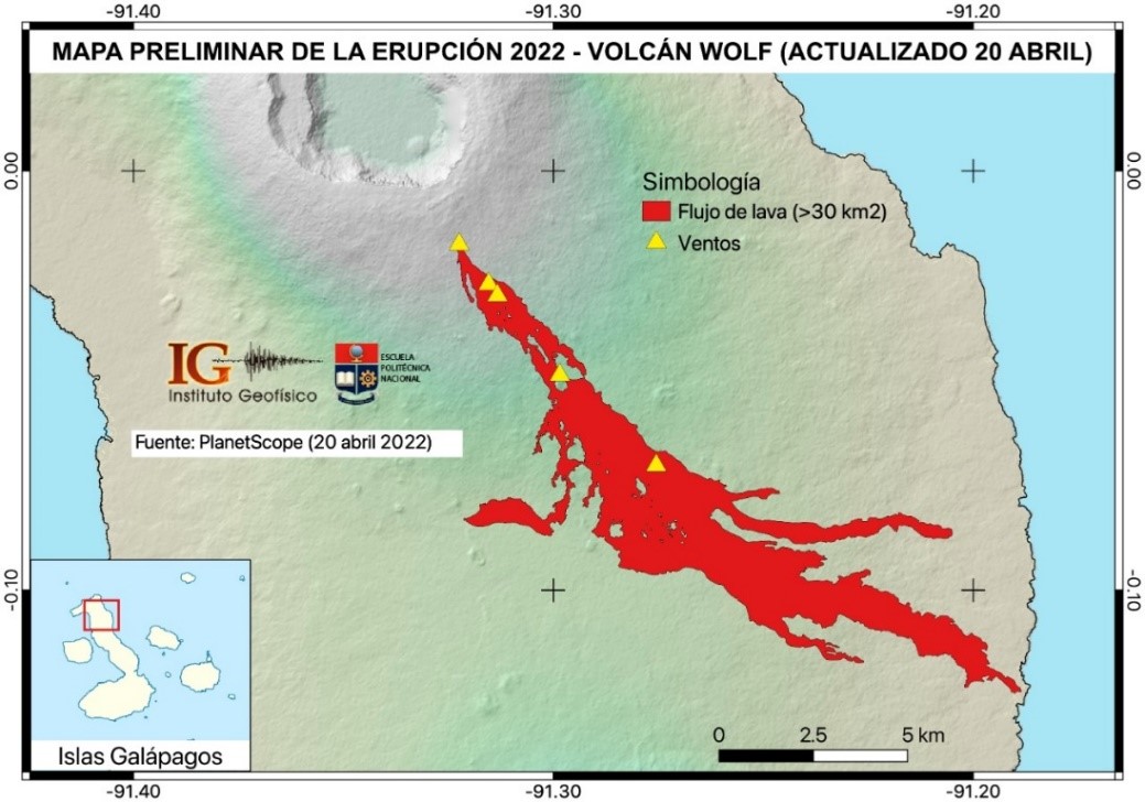
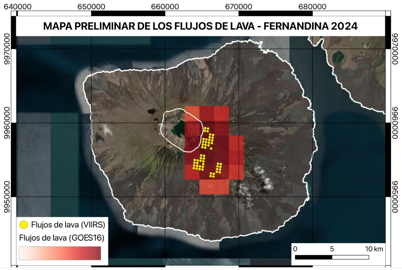
The geostationary satellite GOES-16 recorded thermal anomalies on the southeastern flank of the Fernandina volcano (La Cumbre) from 11:50 p.m. TL (Galapagos) on March 2, corresponding to the descent of lava flows. Additionally, the polar satellites SUOMI-NPP and NOAA-20 recorded more than 1,000 thermal anomalies as they passed over the Galapagos at 00:44 TL and 01:35 TL on March 3, respectively. With this combined information, the first preliminary map of the eruption was prepared using tools developed by the Geophysical Institute (Vasconez et al., 2022). The figure shows that the lava flows come from a circumferential crack located on the southeast flank of the volcano. Previously, the fissure has a length of between 3 and 5 km, while the lava flows have a maximum range of 5 to 6 km, without reaching the sea.

Source : IGEPN

Photos : Doménica Guerrero / JeffO’Marley Herrera, John Garate via Sherine France , IGEPN.


Iceland , Reykjanes Peninsula : 

Continued increased likelihood of an eruption. Magma continues to accumulate beneath Svartsengi

Updated 3. March at 12:15 UTC

Likely scenario over the next few days

Magma volume beneath Svartsengi continues to increase, which could lead to another magma propagation and even a volcanic eruption.
A volcanic eruption could start with a very short warning time, event less than 30 minutes.
A volcanic eruption is most likely to occur in the area between mt. Stóra-Skógfell and mt. Hagafell.
The Icelandic Meteorological Office has updated the hazard assessment map due to the decrease in seismic activity in the Reykjanes peninsula.

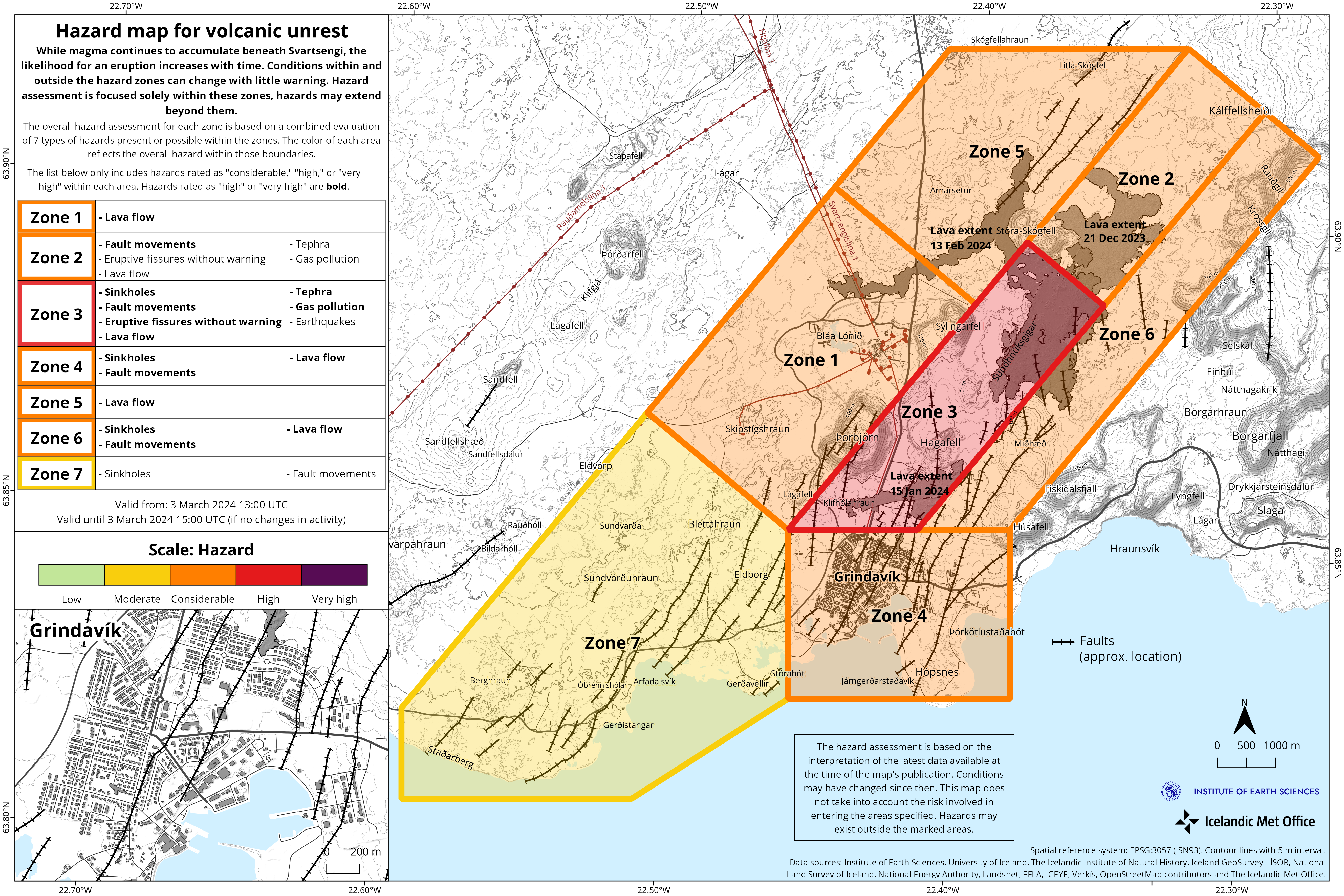
Considering the developments in activity since yesterday, the hazard level has been lowered in two zones – Zones 2 and 3. The hazard level remains unchanged in other areas, thus the hazard assessment is now the same as it was prior to yesterday‘s event.

The hazard assessment map is valid from 13:00 UTC today, 3 March, until 15:00 Tuesday 5 March unless development in activity call for a re-evaluation.

Source et photo : IMO


La Réunion , Piton de la Fournaise :

Seismicity
In February 2024, the OVPF-IPGP recorded in total at the Piton de la Fournaise massif:
• 12 superficial volcano-tectonic earthquakes (0 to 2.5 km above sea level) under the summit craters;
• 3 deep earthquakes (below sea level);
• 24 long-period earthquakes;
• 263 landslides.
The month of February 2024 was marked by low seismicity under the Piton de la Fournaise with only 12 superficial volcano-tectonic earthquakes and three deep earthquakes recorded.
Only two deep volcano-tectonic earthquakes could be located, under the Dolomieu crater and under the western part of the Enclos Fouqué. The others – of lower magnitudes – could not be located.
Numerous (263) landslides in the Dolomieu Crater, at the Cassé de la Rivière de l’Est and at the level of recent lava flows were also recorded.

Deformation
In November 2023, a resumption of peak inflation was recorded. This stopped at the end of November and was followed by a period of peak deflation until the end of 2023.
A trend towards a resumption of building inflation seems visible since the second half of February on the baselines located at the base of the terminal cone. This trend will be confirmed with next month’s observations.

Balance sheet
Since December 2023, magma replenishment and pressurization of the surface reservoir have ceased.
In February 2024, seismicity remained low with only 12 volcano-tectonic earthquakes recorded under the summit craters. A trend towards a resumption of building inflation seems visible since the second half of February on the baselines located at the base of the terminal cone. This trend will be confirmed with next month’s observations.
Note that since 2016, the replenishment of the superficial magmatic reservoir under the Piton de la Fournaise has taken place in pulses, thus such phases of calm in deformations and seismicity have already been observed on several occasions between 2016 and 2023 over periods ranging from 15 days to several months.

Source : OVPF.
Photo : Tunnels de lave Réunion : Rando-Volcan ( archive).

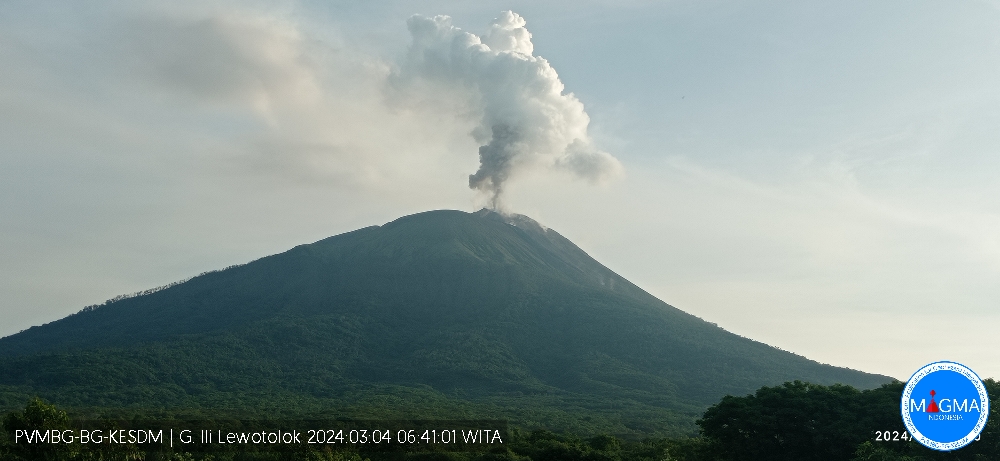
Indonesia , Ili Lewotolok : 

An eruption of Mount Ili Lewotolok occurred on Monday, March 4, 2024 at 06:36 WITA with the height of the ash column observed at ±500 m above the summit (±1923 m above sea level). The ash column was gray in color with moderate to thick intensity, oriented towards the Northwest. This eruption was recorded on a seismograph with a maximum amplitude of 14.7 mm and a duration of 30 seconds.

SEISMICITY OBSERVATIONS:
11 eruption/explosion earthquakes with amplitude of 14.7 to 38 mm and duration of 30 to 115 seconds.
103 emission earthquakes with an amplitude of 1.6 to 27.5 mm and earthquake duration of 21 to 107 seconds.
16 non-harmonic tremors with amplitude from 2 to 28.3 mm and earthquake duration from 84 to 334 seconds.
1 local tectonic earthquake with an amplitude of 11.3 mm, and duration of the earthquake of 39 seconds.

RECOMMENDATION
At Level III activity level (SIAGA), it is recommended:
-Communities around Mount Ili Lewotolok as well as visitors/climbers/tourists should not enter or conduct activities within a 2 km radius around the Mount Ili Lewotolok activity center, and residents of the villages of Lamawolo, Lamatokan and Jontona village should always be alert to the potential threat of danger from lava avalanches and hot clouds originating from the eastern part of the summit/crater of Mount Ili Lewotolok.

Source et photo : Magma Indonésie .

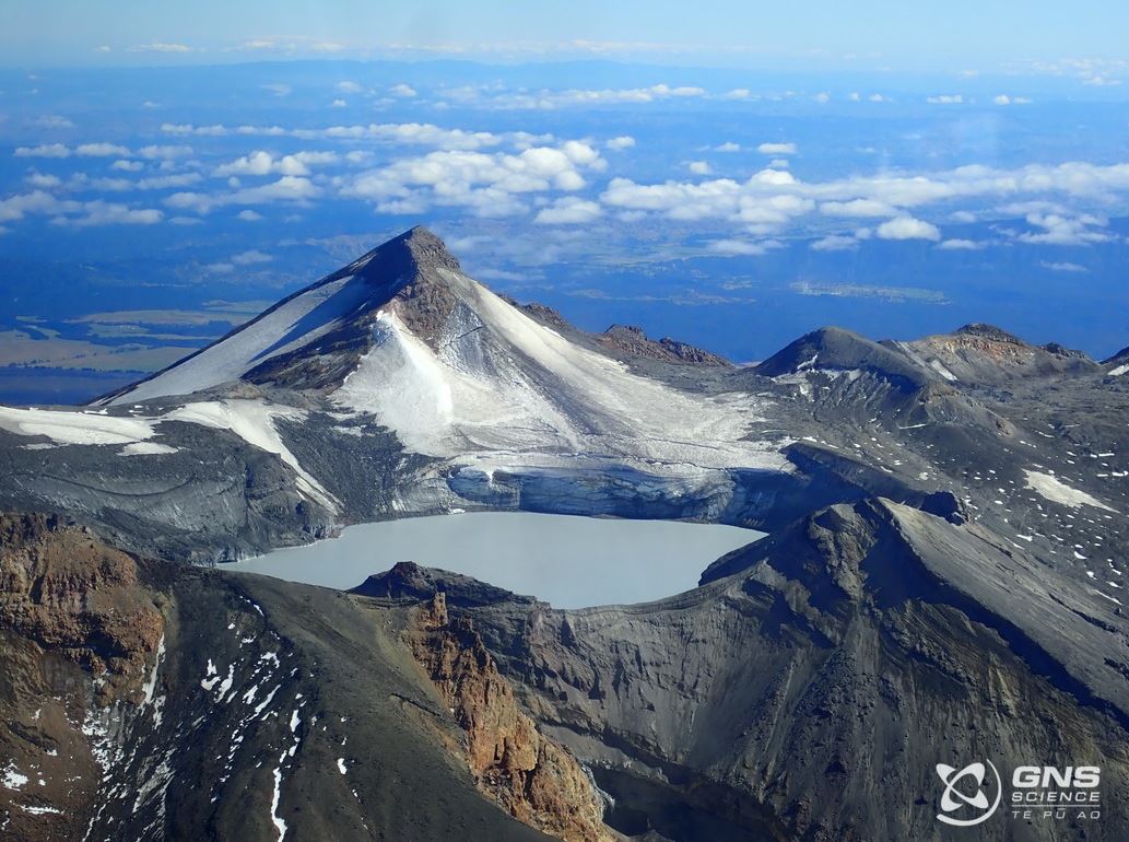
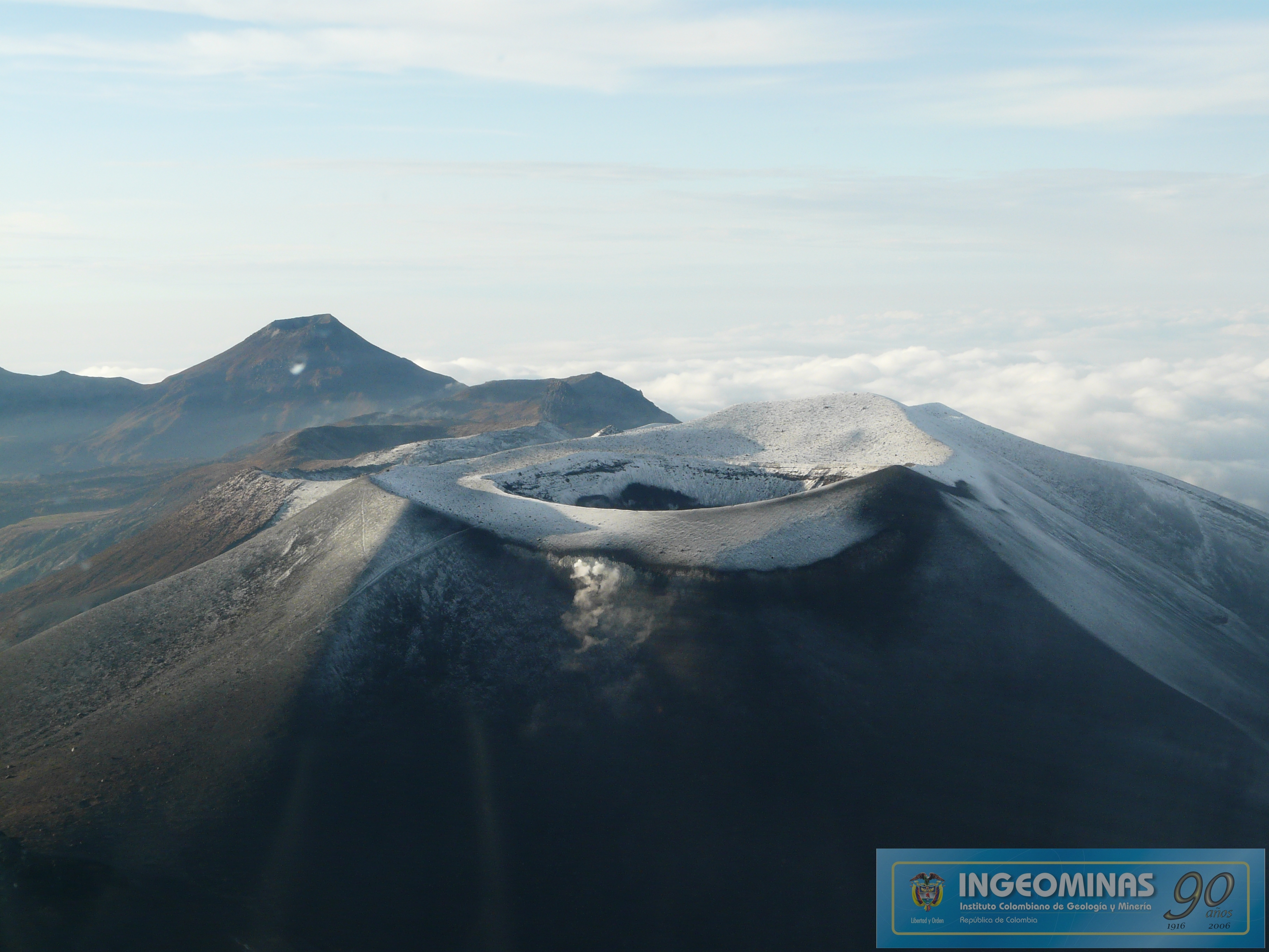
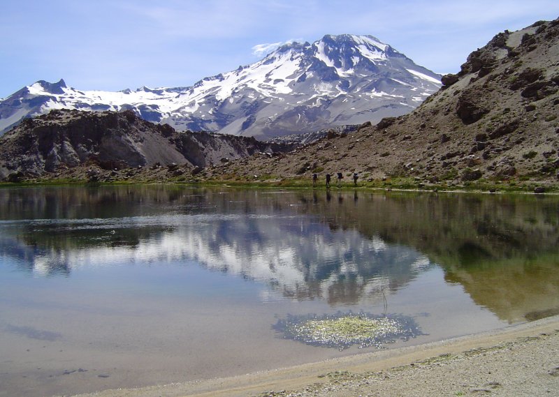
Chile , Descabezado Grande :

Special Report on Volcanic Activity (REAV), Maule region, Descabezado Grande volcanic complex, March 3, 2024, 4:58 a.m. local time (mainland Chile)

The National Geology and Mining Service of Chile (Sernageomin) announces the following PRELIMINARY information, obtained through the monitoring equipment of the National Volcanic Monitoring Network (RNVV), processed and analyzed at the Andes del Sud Volcanological Observatory ( Ovdas):

On Sunday March 3, 2024 at 4:38 a.m. local time (7:38 a.m. UTC), monitoring stations installed near the Descabezado Grande volcanic complex recorded an earthquake associated with the fracturing of rocks inside the volcanic system (VT volcano-tectonic type) .


The characteristics of the earthquake after its analysis are as follows:

ORIGINAL TIME: 04:38 local time (07:38 UTC)
LATITUDE: 35.580° S
LONGITUDE: 70.752°E
DEPTH: 2.2 km
LOCAL MAGNITUDE: 3 (ML)

Comments:

After the mentioned event, other lower energy volcano-tectonic events were recorded. Images from IP cameras did not show superficial activity.

The technical volcanic alert remains at the Green level.

Source : Sernageomin.

Photo : Wikiheinz

04 Mars 2024. FR. Equateur / Iles Galapagos : Fernandina , Islande : Péninsule de Reykjanes , La Réunion : Piton de la Fournaise , Indonésie : Ili Lewotolok , Chili : Descabezado Grande .

04 Mars 2024.


Equateur / Iles Galapagos , Fernandina :

Rapport volcanique spécial – Fernandina. Le volcan Fernandina (La Cumbre), îles Galapagos, entame une nouvelle période éruptive .

Figure 1. Début de l’éruption du volcan Fernandina (Galapagos). Sur l’image, l’émission de gaz est observée à une hauteur comprise entre 2 et 3 km au-dessus du niveau du sommet vers l’Ouest. L’incandescence correspond aux coulées de lave. Photographie récupérée auprès des auteurs Facebook Doménica Guerrero et Jeff O’Marley Herrera. Publié par Radio Santa Cruz.

résumé
Le samedi 2 mars 2024 à 23h50 (heure des Galapagos), le volcan Fernandina (La Cumbre) a entamé un nouveau processus éruptif, 4 ans après sa dernière éruption (janvier 2020). Les émissions de gaz et les anomalies thermiques ont été détectées à l’aide des systèmes satellitaires GOES-16 et VIIRS. Des images partagées sur les réseaux sociaux confirment l’éruption à travers une fissure circonférentielle située dans la partie supérieure du flanc Sud-Est. Dans les heures qui ont suivi, le nuage de gaz, sans beaucoup de cendres, s’est déplacé sous l’effet du vent vers l’Ouest, le Nord-Nord-Ouest et le Sud-Sud-Est  . Il est important d’indiquer que l’île Fernandina ne compte aucun établissement humain et qu’il n’y a donc aucun risque pour les personnes. La durée de l’éruption ne peut pas être prédite avec précision, ni si elle atteindra le bord de mer, mais selon les données sur la déformation du volcan accumulées depuis la dernière période éruptive, il est probable que l’éruption actuelle sera plus importante que celles observées en 2017. 2018 et 2020. L’Institut de Géophysique continue de surveiller le phénomène et notifiera en cas de changements significatifs.


Antécédents
Le volcan Fernandina (La Cumbre) a présenté son dernier processus éruptif le 12 janvier 2020, qui a duré environ 9 heures et s’est caractérisé par l’ouverture d’une fissure située sous le bord Est de la caldeira, où des coulées de lave ont été émises vers le flanc Est. (IGEPN, 2020a). De plus, un nuage de gaz a été généré, atteignant une hauteur maximale de 3,5 km au-dessus du niveau de la mer. Dans les semaines qui ont suivi l’éruption, une augmentation de la sismicité associée à la déformation du sol a été enregistrée (Rapport IGEPN, 2020b ; IGEPN, 2021). Avec entre 28 et 30 éruptions enregistrées depuis 1800, le volcan Fernandina présente le taux de récurrence d’éruption le plus élevé des îles Galapagos.

Nuages ​​de cendres et de gaz :
À partir de 23 h 50 TL (heure des Galapagos) le 2 mars, le satellite géostationnaire GOES-16 a enregistré une émission de gaz à environ 2-3 km au-dessus du niveau du sommet avec une très faible teneur en cendres . L’émission a été la plus intense jusqu’à environ 04h00TL avant de diminuer. Le nuage de gaz s’est dirigé vers l’Ouest, le Nord-Nord-Ouest et le Sud-Sud-Est sans dépasser les zones peuplées.

Coulées de lave
Le satellite géostationnaire GOES-16 a enregistré des anomalies thermiques sur le flanc Sud-Est du volcan Fernandina (La Cumbre) à partir de 23h50 TL (Galapagos) le 2 mars, correspondant à la descente de coulées de lave. De plus, les satellites polaires SUOMI-NPP et NOAA-20 ont enregistré plus de 1000 anomalies thermiques lors de leur passage au-dessus des Galapagos à 00h44 TL et 01h35 TL le 3 mars, respectivement. Grâce à ces informations combinées, la première carte préliminaire de l’éruption a été préparée à l’aide d’outils développés par l’Institut géophysique (Vasconez et al., 2022). La figure montre que les coulées de lave proviennent d’une fissure circonférentielle située sur le flanc Sud-Est du volcan. Au préalable, la fissure a une longueur comprise entre 3 et 5 km, tandis que les coulées de lave ont une portée maximale de 5 à 6 km, sans atteindre la mer.

Source : IGEPN

Photos : Doménica Guerrero / JeffO’Marley Herrera, John Garate via Sherine France , IGEPN.


Islande , Péninsule de Reykjanes : 

Probabilité toujours accrue d’une éruption. Le magma continue de s’accumuler sous Svartsengi.

Mise à jour le 3 mars à 12h15 UTC

Scénario probable dans les prochains jours

Le volume de magma sous Svartsengi continue d’augmenter, ce qui pourrait conduire à une autre propagation du magma et même à une éruption volcanique.
Une éruption volcanique pourrait démarrer avec un délai d’avertissement très court, voire inférieur à 30 minutes.
Une éruption volcanique est plus susceptible de se produire dans la zone située entre les monts. Stóra-Skógfell et le mont. Hagafell.
Le Bureau météorologique islandais a mis à jour la carte d’évaluation des risques en raison de la diminution de l’activité sismique dans la péninsule de Reykjanes.

Compte tenu de l’évolution de l’activité depuis hier, le niveau de danger a été abaissé dans deux zones – les zones 2 et 3. Le niveau de danger reste inchangé dans les autres zones, de sorte que l’évaluation des dangers est désormais la même qu’avant l’événement d’hier.

La carte d’évaluation des risques est valable à partir de 13h00 UTC aujourd’hui 3 mars jusqu’à 15h00 le mardi 5 mars, sauf si l’évolution de l’activité nécessite une réévaluation.

Source et photo : IMO


La Réunion , Piton de la Fournaise :

Sismicité
Au mois de février 2024, l’OVPF-IPGP a enregistré au niveau du massif du Piton de la Fournaise au total :
• 12 séismes volcano-tectoniques superficiels (0 à 2,5 km au-dessus du niveau de la mer) sous les cratères sommitaux ;
• 3 séismes profonds (sous le niveau de la mer) ;
• 24 séismes de type longue-période ;
• 263 éboulements.
Le mois de février 2024 aura été marqué par une faible sismicité sous le Piton de la Fournaise avec uniquement 12 séismes volcano-tectoniques superficiels  et trois séismes profonds enregistrés.
Seuls deux séismes volcano-tectoniques profonds ont pu être localisés, sous le cratère Dolomieu et sous la partie Ouest de l’Enclos Fouqué . Les autres – de plus faibles magnitudes – n’ont pas pu être localisés.
De nombreux (263) éboulements dans le Cratère Dolomieu, au Cassé de la Rivière de l’Est et au niveau des coulées de lave récentes ont aussi été enregistrés .

Déformation
En novembre 2023, une reprise de l’inflation sommitale a été enregistrée  . Celle-ci s’est arrêtée à la fin novembre et fut suivie d’une période de déflation sommitale jusque fin 2023.
Une tendance à la reprise de l’inflation de l’édifice semble visible depuis la deuxième quinzaine de février sur les lignes de base situées à la base du cône terminal. Cette tendance sera à confirmer avec les observations du mois prochain.
Bilan
Depuis décembre 2023 la réalimentation en magma et la pressurisation du réservoir superficiel ont cessé.
En février 2024, la sismicité est restée faible avec uniquement 12 séismes volcano-tectoniques enregistrés sous les cratères sommitaux. Une tendance à la reprise de l’inflation de l’édifice semble visible depuis la deuxième quinzaine de février sur les lignes de base situées à la base du cône terminal. Cette tendance sera à confirmer avec les observations du mois prochain.
A noter que depuis 2016, les réalimentations du réservoir magmatique superficiel sous le Piton de la Fournaise se font par impulsions, ainsi de telles phases d’accalmie dans les déformations et la sismicité ont déjà été observées à plusieurs reprises entre 2016 et 2023 sur des périodes allant de 15 jours à plusieurs mois.
Source : OVPF.
Photo : Tunnels de lave Réunion : Rando-Volcan ( archive).

Indonésie , Ili Lewotolok : 

Une éruption du mont Ili Lewotolok s’est produite le lundi 4 mars 2024 à 06h36 WITA avec la hauteur de la colonne de cendres observée à ± 500 m au-dessus du sommet (± 1923 m au-dessus du niveau de la mer). La colonne de cendres était de couleur grise avec une intensité modérée à épaisse , orientée vers le Nord-Ouest. Cette éruption a été enregistrée sur un sismographe avec une amplitude maximale de 14,7 mm et une durée de 30 secondes.

OBSERVATIONS DE JA SISMICITE:
11 séismes d’éruption / explosions d’une amplitude de 14,7 à 38 mm et d’une durée de 30 à 115 secondes.
103 tremblements de terre d’émissions d’une amplitude de 1,6 à 27,5 mm et durée du séisme de 21 à 107 secondes.
16 tremors non harmoniques d’une amplitude de 2 à 28,3 mm et d’une durée de tremblement de terre de 84 à 334 secondes.
1 séisme tectonique local d’une amplitude de 11,3 mm, et durée du séisme de 39 secondes.

RECOMMANDATION
Au niveau d’activité Niveau III (SIAGA), il est recommandé :
-Les communautés autour du mont Ili Lewotolok ainsi que les visiteurs/grimpeurs/touristes ne doivent pas entrer ou mener des activités dans un rayon de 2 km autour du centre d’activités du mont Ili Lewotolok, et les habitants des villages de Lamawolo, Lamatokan  et le village de Jontona doivent toujours être attentifs à la menace potentielle de danger provenant d’avalanches de lave et de nuages ​​chauds provenant de la partie orientale du sommet/cratère du mont Ili Lewotolok.

Source et photo : Magma Indonésie .

Chili , Descabezado Grande :

Rapport spécial sur l’activité volcanique (REAV), région du Maule, complexe volcanique Descabezado Grande, 03 Mars 2024, 04 h 58, heure locale (Chili continental)

Le Service national de géologie et des mines du Chili (Sernageomin) annonce les informations PRÉLIMINAIRES suivantes, obtenues grâce à l’équipement de surveillance du Réseau national de surveillance volcanique (RNVV), traitées et analysées à l’Observatoire volcanologique des Andes del Sud (Ovdas) :

Le Dimanche 03 Mars 2024 à 04h38 heure locale (07h38 UTC) , les stations de surveillance installées à proximité du complexe volcanique Descabezado Grande ont enregistré un séisme associé à la   fracturation de roches  à l’intérieur du système volcanique ( type volcano-tectonique VT ).


Les caractéristiques du séisme après son analyse sont les suivantes :

HEURE D’ORIGINE : 04h38 heure locale (07h38 UTC)
LATITUDE : 35.580° S
LONGITUDE: 70,752°E
PROFONDEUR : 2,2 km
MAGNITUDE LOCALE : 3 (ML)

Observations :

Postérieurement à l’évènement mentionné , il a été enregistré d’autres évènements de type volcano-tectonique  de plus faible énergie . Les images des caméras IP n’ont pas montré d’activité superficielle .

L’alerte technique volcanique reste au niveau Vert.

Source : Sernageomin.

Photo : Wikiheinz

May 06 , 2022. EN . Indonesia : Ibu , New Zealand : Ruapehu , Italy : Vulcano , Colombia , Puracé , Ecuador / Galapagos : Wolf , Hawaii : Kilauea .

May 06 ,  022.


Indonesia , Ibu :

VOLCANO OBSERVATORY NOTICE FOR AVIATION – VONA

Issued : May 05 , 2022
Volcano : Ibu (268030)
Current Aviation Colour Code : ORANGE
Previous Aviation Colour Code : orange
Source : Ibu Volcano Observatory
Notice Number : 2022IBU31
Volcano Location : N 01 deg 29 min 17 sec E 127 deg 37 min 48 sec
Area : North Maluku, Indonesia
Summit Elevation : 4240 FT (1325 M)

Volcanic Activity Summary :
Eruption with volcanic ash cloud at 09h25 UTC (18h25 local).

Volcanic Cloud Height :
Best estimate of ash-cloud top is around 7440 FT (2325 M) above sea level, may be higher than what can be observed clearly. Source of height data: ground observer.

Other Volcanic Cloud Information :
Ash-cloud moving to west.

Remarks :
Eruption and ash emission is continuing.

Source : Magma Indonésie .

Photo : PVMBG.


New Zealand , Ruapehu :

The temperature of the water in Ruapehu’s crater lake has risen again and GNS Science is keeping a close eye on what this might mean for the risk of a substantial eruption.

The agency’s duty volcanologist Geoff Kilgour said Friday it’s pretty much steady as she goes ahead of the weekend with the volcanic alert status at Ruapehu unchanged at 2.
But the temperature rise is being monitored closely for a range of reasons.
Kilgour’s explanation illustrates the scientific skill needed to assess the risk of an eruption of volcanic material and ash. He said the temperature of the crater lake, Te Wai a-moe, has gone up from 39 degrees Celsius to 40 C since Tuesday’s last volcanic alert level bulletin.
This wasn’t so concerning on its own as it was continuing a trend that started earlier in the week. But whether the rise meant more or less risk of an eruption wasn’t certain, Kilgour said.
The temperature rise did indicate there was more volcanic fluid and gas coming into the lake, which acts as a cap that helps prevent eruptions of material and ash.

The larger central vent opened only recently for the first time in the latest round of more significant activity at Ruapehu. That central vent is the main source of volcanic fluid and gas heating the water. Central vent [produces] a really large bubble, tens of metres across, » said Kilgour.
On whether the slow warming increased the risk of an actual eruption, Kilgour said: « That’s a tricky one. »

The fact that central vent was open could help ease pressure below the lake as “it’s releasing some of the pressure there”. That pressure reduction could cut the risk of an eruption.
But, on the other hand, the fact central vent was open could also mean hot volcanic magma may rise towards the waters of the lake, resulting in the production of more steam and ejection of water.

Given the lake acts as a cap helping stop explosions of volcanic material and ash, any resulting significant lowering of the lake’s water level would be of concern.
« Then we might see larger eruptions start to happen, » said Kilgour.

GNS Science said this week that the chances of a prolonged eruptive episode or a larger eruption, such as occurred in 1995-96 with wider ashfall impacts, is higher than it was two months ago but remains very unlikely. Such an eruption would most likely only follow a sequence of smaller eruptions.

Source : stuff.co.nz

Photo : Geonet.


Italy , Vulcano :

WEEKLY BULLETIN, from April 25, 2022 to May 01, 2022. (issue date May 03, 2022)

ACTIVITY STATUS SUMMARY

In the light of the surveillance data, it is highlighted:
1) Temperature of the crater fumaroles: The temperatures recorded on the rim of the crater show stable values at high levels
2) CO2 flux in the crater area: The latest measurements show high values.
3) SO2 flux in the crater area: SO2 flux at a medium-high and stable level
4) Geochemistry of fumarolic gases: No update is available: the last sampling of March 31 confirmed the downward trend in the concentration of magmatic gases in the fumaroles of Vulcano.

5) CO2 fluxes at the base of the La Fossa cone and in the Vulcano Porto area: The CO2 fluxes recorded in the C. Sicilia, Rimessa and P4max sites continue to show a slight downward trend, but remain on medium-high values; in the Faraglione site there are values ​​close to the background.
6) Geochemistry of thermal aquifers: The temperature measured in the Camping Sicilia well is at high and stable values. The electrical conductivity shows low values, although slightly increasing.
The level values ​​measured in the Bambara well show a moderate upward trend. Conductivity values ​​continue to show a gradual decrease even though they remain at medium-high levels.
7) Local seismicity: low level of local seismic activity
8) Regional seismicity: low seismic fracturing activity.
9) Deformations – GNSS: The network of permanent GNSS stations has not recorded any significant changes.
10) Deformations – Inclinometry: The inclinometric network has not recorded any significant changes.
11) Other observations: Monthly CO2 flux campaign: a clear decrease in CO2 emissions is observed in the Vulcano Porto area; however, average soil CO2 emissions still remain at abnormal levels.
Monthly drilling campaign: there is a stabilization of the supply of fluids of fumarolic origin to the thermal aquifer, which still remains at abnormal levels.
Gravimetry: No significant changes were recorded during the period considered.

CRATER FUMEROLES TEMPERATURE:

Along the upper edge, the maximum emission temperature has very stable values ​​(T1: 382-383°C), with a weekly average of 383°C (hourly data recorded between April 26 and May 3). The fumarole field has equivalent emission temperatures over the entire summit fracture line, confirming a thermal anomaly still maintained by a constant vapor flow: fumarole F5 (sensor T3) showed emission temperatures (T MAX 377; min 376°C) superimposed on the temperatures of sensor T2 placed in F5AT, up to the date of the failure (April 28).
The maximum temperature recorded at the level of the sensor placed on the internal slope was 111°C, but the site is disturbed by exogenous effects.

CO2 FLOW AT THE BASE OF LA FOSSA CONE AND IN THE VULCANO PORTO AREA
The CO2 fluxes at the base of the crater in the C. Sicilia site show average to high values, above the background, although in sharp decrease compared to the November-December 2021 period; average values ​​were recorded on the Rimessa site, stable compared to last week; the P4max site displays medium-high values, which fluctuate cyclically; in the Faraglione site there are values ​​close to the background level

Source : INGV.

Read the article: https://www.ct.ingv.it/index.php/monitoraggio-e-sorveglianza/prodotti-del-monitoraggio/bollettini-settimanali-multidisciplinari/634-bollettino-settimanale-sul-monitoraggio-vulcanico-geochimico-e-sismico-del-vulcano-Vulcano-del-2022-05-03/file

Photos : INGV , INGV-Roma1 .


Colombia , Puracé :

Weekly bulletin of the activity of the Puracé volcano – Los Coconucos volcanic chain
The activity level of the volcano continues at the Yellow activity level or (III): changes in the behavior of volcanic activity.

From the analysis and evaluation of the information obtained through the monitoring network of the Puracé volcano – Los Coconucos volcanic chain, during the week of April 26 to May 2, 2022, the COLOMBIAN GEOLOGICAL SERVICE – Volcanological and Seismological Observatory de Popayán informs that:

Regarding the number and released energy of recorded seismic events, a stable behavior was observed, compared to previous weeks. For the period evaluated, 464 seismic events were recorded, of which 67 were associated with rock fracturing processes (type VT) and 397 with fluid dynamics in volcanic conduits; Of these, 357 were classified as long period type events (LP type), six (6) hybrid type (HB) events, 13 low frequency events (BF type) and 21 as low input tremor pulses. energy (type TR).
The geodetic network of GNSS (Global Navigation Satellite System) stations for monitoring ground deformation continues to record a process associated with inflation.

Regarding volcanic gas monitoring, sulfur dioxide (SO2) flux emissions recorded by telemetry and field stations show an increase compared to the previous week, reaching flow values ​​in the mobile instrument of 2011 t/day for April. 28 and a throughput in permanent stations with a maximum emitted of 2409 t/day. The other gas analysis instruments in the volcanic influence zone do not show any relevant changes for the evaluated period.

In the monitoring of surface activity, images were obtained during the week thanks to the Mina, Lavas Rojas and Cerro Sombrero web cameras, which showed degassing of the volcanic system, with a white column oriented preferentially towards the North -West.

Sensors monitoring magnetic and electric fields and infrasonic waves did not record variations associated with changes in volcanic activity.
Therefore, it is concluded that significant variations in volcanic activity continue to be recorded, in accordance with the behavior expected at activity level III (yellow level), which could evolve towards states of greater activity. The Colombian Geological Service continues to monitor the evolution of the volcanic phenomenon and will report any changes that may occur in due course.

Source : SGC.

Photo : Ingeominas.


Ecuador / Galapagos , Wolf :

APPARENT END OF THE ERUPTIVE PERIOD.

The Wolf volcano (height: 1710 m) located in the northern part of Isabela Island in the Galapagos archipelago, began a new eruptive period at 11:20 p.m. on January 6, 2022, Galapagos time (00:20 on January 7, 2022, Galapagos time). mainland of Ecuador). The evolution of this eruption was monitored by seismic stations and different satellite systems, thanks to which it was possible to check mainly the emission and the advance of the lava flows, as well as the emissions of volcanic gases.
The lava flows were emitted from an approximately 8 km radial fissure with at least 5 vents located on the southeast flank of the volcano. The lavas flowed to a maximum distance of about 18.5 km, without having reached the coastal margin (Figure 1) and covered an approximate area of more than 30 km2.

Preliminary map of lava flows emitted during the eruption of the Wolf volcano which began in January 2022 (Galapagos Islands). The map was made based on satellite images from PlanetScope. It can be observed that the lava flows covered an area of ​​more than 30 km2, and that their maximum distribution area was about 18.5 km from the highest vent, without having reached the coastal margin (F.J. Vasconez).

Hundreds of satellite thermal alerts were recorded daily based on the location of these lava flows. However, these alerts have gradually decreased in recent days until they are almost absent, which is interpreted as a decrease in the emission rate of lava flows and a significant cooling of them. Likewise, the degassing of sulfur dioxide (SO2) shows a downward trend, so that at the date of this report, a month has already passed without reports of SO2 emissions.

Findings:
The monitoring parameters that allow us to assess the evolution of the eruption are: seismic activity, degassing, deformation, thermal alerts, ash emissions. These parameters reached their maximum peak in early January 2022, after which they decreased until returning to baseline (non-eruptive) values. At present, thanks to satellite images, there is no advance of the lava fronts, which seem to have stopped 150-200 meters from the coast and have been gradually cooled.
Based on the technical criteria set out above, this eruptive period is considered to be over. The IG-EPN remains attentive to the possible changes that the Wolf volcano could present and will inform in a timely manner through its official communication channels.

Source : IGEPN.

Read the full article: https://www.igepn.edu.ec/servicios/noticias/1931-informe-especial-volcan-wolf-no-2022-003


Hawaii , Kilauea :

19°25’16 » N 155°17’13 » W,
Summit Elevation 4091 ft (1247 m)
Current Volcano Alert Level: WATCH
Current Aviation Color Code: ORANGE

Activity Summary:
The summit eruption of Kīlauea Volcano, within Halemaʻumaʻu crater, has continued over the past 24 hours. All recent lava activity has been confined to the crater, and current data indicate that this scenario is likely to continue. No significant changes have been noted in the summit or East Rift Zone.

Halemaʻumaʻu crater Lava Lake Observations:
Eruption of lava from the Halemaʻumaʻu western vent into the active lava lake and onto the crater floor has continued over the past 24 hours. The active lava lake has experienced continuous surface activity, and its surface level has been relatively steady over this period. Yesterday saw the continuation of relatively sluggish lava ooze-outs along the northeastern and southern margins of the crater floor, and this morning a particularly vigorous and expansive ooze-out began along the northwestern margin just after 2:00 a.m. Overflight measurements on April 6, 2022 indicated that the crater floor had seen a total rise of about 99 meters (325 feet) and that 66 million cubic meters (18 billion gallons) of lava had been effused since the beginning of this eruption on September 29, 2021.

Summit Observations:
Summit tiltmeters began tracking sharp deflationary tilt around 5:00 a.m. this morning, which continues at this time. Volcanic tremor remains above background levels. A sulfur dioxide (SO2) emission rate of approximately 2,600 tonnes per day (t/d) was measured yesterday, May 4, 2022.

Source : HVO.

Photo : USGS / K. Lynn

06 Mai 022. FR. Indonésie : Ibu , Nouvelle Zélande : Ruapehu , Italie : Vulcano , Colombie , Puracé , Equateur / Galapagos : Wolf , Hawaii : Kilauea .

06 Mai 022.


Indonésie , Ibu :

AVIS D’OBSERVATION DU VOLCAN POUR L’AVIATION – VONA

Publié : 05 mai 2022
Volcan : Ibu (268030)
Code Couleur Aviation Actuel : ORANGE
Code Couleur Aviation précédent : orange
Source : Observatoire du volcan Ibu
Numéro d’avis : 2022IBU31
Emplacement du volcan : N 01 deg 29 min 17 sec E 127 deg 37 min 48 sec
Région : North Maluku, Indonésie
Altitude du sommet : 4240 FT (1325 M).

Résumé de l’activité volcanique :
Eruption avec nuage de cendres volcaniques à 09h25 UTC (18h25 locale).

Hauteur des nuages volcaniques :
La meilleure estimation du sommet du nuage de cendres est d’environ 7440 FT (2325 M) au-dessus du niveau de la mer, peut être plus élevée que ce qui peut être observé clairement. Source des données de hauteur : observateur au sol.

Autres informations sur les nuages volcaniques :
Nuage de cendres se déplaçant vers l’Ouest.

Remarques :
L’éruption et l’émission de cendres se poursuivent.

Source : Magma Indonésie .

Photo : PVMBG.


Nouvelle Zélande , Ruapehu :

La température de l’eau du lac de cratère de Ruapehu a de nouveau augmenté et GNS Science surveille de près ce que cela pourrait signifier pour le risque d’une éruption importante.

Le volcanologue de service de l’agence, Geoff Kilgour, a déclaré vendredi que c’était à peu près stable alors qu’elle avançait le week-end avec le statut d’alerte volcanique à Ruapehu inchangé à 2.
Mais la hausse de la température est surveillée de près pour diverses raisons.
L’explication de Kilgour illustre la compétence scientifique nécessaire pour évaluer le risque d’une éruption de matières volcaniques et de cendres. Il a déclaré que la température du lac de cratère, Te Wai a-moe, est passée de 39 degrés Celsius à 40 ° C depuis le dernier bulletin d’alerte volcanique de mardi.

Ce n’était pas si préoccupant en soi car cela poursuivait une tendance qui avait commencé plus tôt dans la semaine. Mais il n’était pas certain que la hausse signifiait plus ou moins de risque d’éruption, a déclaré Kilgour. L’augmentation de la température a indiqué qu’il y avait plus de fluide volcanique et de gaz entrant dans le lac, ce qui agit comme un bouchon qui aide à prévenir les éruptions de matériaux et de cendres.

Le plus grand évent central n’a ouvert que récemment pour la première fois lors de la dernière série d’activités plus importantes sur le Ruapehu. Cet évent central est la principale source de fluide volcanique et de gaz chauffant l’eau. L’évent central a produit une très grosse bulle, des dizaines de mètres de diamètre », a déclaré Kilgour.

Sur la question de savoir si le lent réchauffement augmentait le risque d’une véritable éruption, Kilgour a déclaré: « C’est délicat » . Le fait que l’évent central était ouvert pourrait aider à réduire la pression sous le lac, car « il libère une partie de la pression là-bas ». Cette réduction de pression pourrait réduire le risque d’éruption.
Mais, d’un autre côté, le fait que l’évent central soit ouvert pourrait également signifier que du magma volcanique chaud peut remonter vers les eaux du lac, entraînant la production de plus de vapeur et l’éjection d’eau.

Étant donné que le lac agit comme un bouchon aidant à arrêter les explosions de matériaux volcaniques et de cendres, toute baisse significative du niveau d’eau du lac qui en résulterait serait préoccupante. « Ensuite, nous pourrions voir des éruptions plus importantes commencer à se produire », a déclaré Kilgour.

Le GNS Science a déclaré cette semaine que les chances d’un épisode éruptif prolongé ou d’une éruption plus importante, comme celle qui s’est produite en 1995-96 avec des impacts de chutes de cendres plus larges, sont plus élevées qu’il y a deux mois, mais restent très peu probables. Une telle éruption ne suivrait très probablement qu’une séquence d’éruptions plus petites.

Source : stuff.co.nz

Photo : Geonet.


Italie , Vulcano :

BULLETIN HEBDOMADAIRE, du 25 Avril 2022 au 01 Mai 2022. (date d’émission 03 Mai  2022)

SOMMAIRE DE L’ÉTAT DE L’ACTIVITÉ

À la lumière des données de surveillance, il est mis en évidence :
1) Température des fumerolles du cratère : Les températures enregistrées sur le rebord du cratère montrent des valeurs stables sur des niveaux élevés
2) Flux de CO2 dans la zone du cratère : Les dernières mesures attestent de valeurs élevées.
3) Flux de SO2 dans la zone du cratère : flux de SO2 à un niveau moyen-élevé et stable
4) Géochimie des gaz fumeroliens : Aucune mise à jour n’est disponible : le dernier prélèvement du 31 mars a confirmé la tendance à la baisse de la concentration des gaz magmatiques dans les fumerolles de Vulcano.

5) Flux de CO2 à la base du cône de La Fossa et dans la zone de Vulcano Porto : Les flux de CO2 enregistrés dans les sites C. Sicilia, Rimessa et P4max continuent d’afficher une légère tendance à la baisse, mais restent sur des valeurs moyennes-élevées ; dans le site de Faraglione, il y a des valeurs proches de l’arrière-plan.
6) Géochimie des aquifères thermiques : La température mesurée dans le puits Camping Sicilia se situe à des valeurs élevées et stables. La conductivité électrique montre des valeurs faibles, bien qu’en légère augmentation.
Les valeurs de niveau mesurées dans le puits Bambara montrent une tendance modérée à la hausse. Les valeurs de conductivité continuent d’afficher une diminution progressive même si elles restent à des niveaux moyens-élevés.
7) Sismicité locale : faible niveau d’activité sismique locale
8) Sismicité régionale : faible activité sismique de fracturation.
9) Déformations – GNSS : Le réseau de stations GNSS permanentes n’a pas enregistré de changements significatifs.
10) Déformations – Inclinométrie : Le réseau inclinométrique n’a pas enregistré de changements significatifs.
11) Autres observations : Campagne mensuelle de flux de CO2 : une nette diminution des émissions de CO2 est observée dans la zone de Vulcano Porto ; cependant, les émissions moyennes de CO2 des sols restent encore à des niveaux anormaux.
Campagne de forage mensuelle : on observe une stabilisation de l’apport des fluides d’origine fumerolienne à l’aquifère thermique, qui reste encore à des niveaux anormaux.
Gravimétrie : Aucun changement significatif n’a été enregistré au cours de la période considérée.

TEMPÉRATURE DES FUMEROLES DU CRATERE :

Le long du bord supérieur, la température maximale d’émission a des valeurs très stables (T1 : 382-383°C), avec une moyenne hebdomadaire de 383°C (données horaires relevées entre le 26 avril et le 3 mai). Le champ fumerolien a des températures d’émission équivalentes sur toute la ligne de fracture sommitale, confirmant une anomalie thermique toujours entretenue par un flux de vapeur constant : la fumerolle F5 (capteur T3) a montré des températures d’émission (T MAX 377 ; min 376°C) superposables aux températures du capteur T2 placé dans F5AT, jusqu’à la date de la panne (28 avril).
La température maximale enregistrée au niveau du capteur placé sur la pente interne était de 111°C mais le site est perturbé par des effets exogènes.

FLUX DE CO2 À LA BASE DU CÔNE DE LA FOSSA ET DANS LA RÉGION DE VULCANO PORTO
Les flux de CO2 à la base du cratère dans le site de C. Sicilia montrent des valeurs moyennes à élevées, supérieures au fond, bien qu’en forte diminution par rapport à la période novembre-décembre 2021 ; des valeurs moyennes ont été relevées sur le site de Rimessa , stables par rapport à la semaine dernière ; le site P4max affiche des valeurs moyennes-élevées, qui fluctuent de manière cyclique ; dans le site Faraglione il y a des valeurs proches du niveau de fond

Source : INGV.

Lire l’article https://www.ct.ingv.it/index.php/monitoraggio-e-sorveglianza/prodotti-del-monitoraggio/bollettini-settimanali-multidisciplinari/634-bollettino-settimanale-sul-monitoraggio-vulcanico-geochimico-e-sismico-del-vulcano-Vulcano-del-2022-05-03/file

Photos : INGV , INGV-Roma1 .


Colombie , Puracé :

Bulletin hebdomadaire de l’activité du volcan Puracé – Chaîne volcanique Los Coconucos
Le niveau d’activité du volcan continue au niveau d’activité Jaune ou (III) : changements dans le comportement de l’activité volcanique.

À partir de l’analyse et de l’évaluation des informations obtenues grâce au réseau de surveillance du volcan Puracé – chaîne volcanique Los Coconucos, au cours de la semaine du 26 avril au 2 mai 2022, le SERVICE GÉOLOGIQUE COLOMBIEN – Observatoire volcanologique et sismologique de Popayán informe que :

En ce qui concerne le nombre et l’énergie libérée des événements sismiques enregistrés, un comportement stable a été observé, par rapport aux semaines précédentes. Pour la période évaluée, 464 événements sismiques ont été enregistrés, dont 67 étaient associés à des processus de fracturation des roches (type VT) et 397 à la dynamique des fluides dans des conduits volcaniques ; Parmi ces derniers, 357 ont été classés comme événements de type longue période (type LP), six (6) événements de type hybride (HB), 13 événements de basse fréquence (type BF) et 21 comme impulsions de tremor à faible apport d’énergie (type TR).  
Le réseau géodésique de stations GNSS (Global Navigation Satellite System) pour la surveillance de la déformation du sol continue d’enregistrer un processus associé à l’inflation.

En ce qui concerne la surveillance des gaz volcaniques, les émissions de flux de dioxyde de soufre (SO2) enregistrées par la télémétrie et les stations de terrain montrent une augmentation par rapport à la semaine précédente, atteignant des valeurs de débit dans l’instrument mobile de 2011 t/jour pour avril. 28 et un débit en stations permanentes avec un maximum émis de 2409 t/jour. Les autres instruments d’analyse de gaz dans la zone d’influence volcanique ne montrent pas de changements pertinents pour la période évaluée.

Dans le suivi de l’activité de surface, des images ont été obtenues au cours de la semaine grâce aux caméras Web Mina, Lavas Rojas et Cerro Sombrero, qui ont montré un dégazage du système volcanique, avec une colonne blanche orientée préférentiellement vers le Nord-Ouest.

Les capteurs de surveillance des champs magnétiques et électriques et des ondes infrasonores n’ont pas enregistré les variations associées aux changements de l’activité volcanique.
Par conséquent, il est conclu que des variations importantes de l’activité volcanique continuent d’être enregistrées, conformément au comportement attendu au niveau d’activité III (niveau jaune), qui pourrait évoluer vers des états d’activité plus importante. Le Service géologique colombien continue de surveiller l’évolution du phénomène volcanique et signalera tout changement qui pourrait survenir en temps opportun.

Source : SGC.

Photo : Ingeominas.


Equateur / Galapagos , Wolf :

FIN APPARENTE DE LA PÉRIODE ÉRUPTIVE.

Le volcan Wolf (hauteur: 1710 m ) situé dans la partie Nord de l’île Isabela dans l’archipel des Galapagos, a commencé une nouvelle période éruptive à 23h20 le 6 janvier 2022, heure des Galapagos (00h20 le 7 janvier 2022, heure continentale de l’Équateur). L’évolution de cette éruption a été suivie par des stations sismiques et différents systèmes satellitaires, grâce auxquels il a été possible de vérifier principalement l’émission et l’avancée des coulées de lave, ainsi que les émissions de gaz volcaniques.
Les coulées de lave ont été émises par une fissure radiale d’environ 8 km avec au moins 5 évents situés sur le flanc Sud-Est du volcan. Les laves ont coulé jusqu’à une distance maximale d’environ 18,5 km, sans avoir atteint la marge côtière (figure 1) et ont couvert une superficie approximative de plus de 30 km2.

Carte préliminaire des coulées de lave émises lors de l’éruption du volcan Wolf qui a débuté en janvier 2022 (îles Galapagos). La carte a été réalisée sur la base d’images satellites de PlanetScope. On peut observer que les coulées de lave ont couvert une superficie de plus de 30 km2, et que leur aire de répartition maximale a été d’environ 18,5 km depuis l’évent le plus haut , sans avoir atteint la marge côtière (F.J. Vasconez).

Des centaines d’alertes thermiques par satellite ont été enregistrées quotidiennement en fonction de l’emplacement de ces coulées de lave. Cependant, ces alertes ont progressivement diminué ces derniers jours jusqu’à ce qu’elles soient presque absentes, ce qui est interprété comme une diminution du taux d’émission des coulées de lave et un refroidissement significatif de celles-ci. De même, le dégazage du dioxyde de soufre (SO2) montre une tendance à la baisse, de sorte qu’à la date de ce rapport, un mois s’est déjà écoulé sans rapports d’émissions de SO2.

Conclusions:
Les paramètres de surveillance qui nous permettent d’évaluer l’évolution de l’éruption sont : l’activité sismique, le dégazage, la déformation, les alertes thermiques, les émissions de cendres. Ces paramètres ont atteint leur pic maximal début janvier 2022, après quoi ils ont diminué jusqu’à revenir aux valeurs de base (non éruptives). À l’heure actuelle, grâce aux images satellites, il n’y a pas d’avancée des fronts de lave, qui semblent s’être arrêtés à 150-200 mètres de la côte et ont été progressivement refroidis.
Sur la base des critères techniques énoncés ci-dessus, cette période éruptive est considérée comme terminée. L’IG-EPN reste attentif aux changements possibles que le volcan Wolf pourrait présenter et informera en temps opportun via ses canaux de communication officiels.

Source : IGEPN.

Lire l’article en entier https://www.igepn.edu.ec/servicios/noticias/1931-informe-especial-volcan-wolf-no-2022-003


Hawaii , Kilauea :

19°25’16 » N 155°17’13 » O,
Altitude du sommet : 4091 pieds (1247 m)
Niveau d’alerte volcanique actuel : ATTENTION
Code couleur actuel de l’aviation : ORANGE

Résumé de l’activité :
L’éruption au sommet du volcan Kīlauea, dans le cratère Halema’uma’u, s’est poursuivie au cours des dernières 24 heures. Toute l’activité de lave récente a été confinée au cratère, et les données actuelles indiquent que ce scénario est susceptible de se poursuivre. Aucun changement significatif n’a été noté au sommet ou dans la zone du Rift Est.

Observations du lac de lave du cratère Halemaʻumaʻu :
L’éruption de lave de l’évent Ouest de Halema’uma’u dans le lac de lave actif et sur le fond du cratère s’est poursuivie au cours des dernières 24 heures. Le lac de lave actif a connu une activité de surface continue et son niveau de surface a été relativement stable au cours de cette période. Hier, des suintements de lave relativement lents se sont poursuivis le long des marges Nord-Est et Sud du fond du cratère, et ce matin, un suintement particulièrement vigoureux et expansif a commencé le long de la marge Nord-Ouest juste après 2 heures du matin. Les mesures prises lors du survol le 6 avril, 2022 a indiqué que le fond du cratère avait connu une élévation totale d’environ 99 mètres (325 pieds) et que 66 millions de mètres cubes (18 milliards de gallons) de lave avaient été effusés depuis le début de cette éruption le 29 septembre 2021.

Observations du sommet :
Les inclinomètres du sommet ont commencé à suivre une forte inclinaison déflationniste vers 5 heures du matin ce matin, qui se poursuit à cette heure. Le tremor volcanique reste au-dessus des niveaux de fond. Un taux d’émission de dioxyde de soufre (SO2) d’environ 2 600 tonnes par jour (t/j) a été mesuré hier, le 4 mai 2022.

Source : HVO.

Photo : USGS / K. Lynn

March 25 , 2022. EN . Canary Islands / La Palma : Cumbre Vieja , Philippines : Taal , The Azores : São Jorge , Alaska : Pavlof , Indonesia : Anak Krakatau , Ecuador / Galapagos : Sierra Negra .

25 Mars 2022.


Canary Islands / La Palma , Cumbre Vieja :

As of 7:01 p.m. on March 24, 2022, the Canaria seismic sensor network, operated by INVOLCAN, records a swarm of long-period type seismic events on the Cumbre Vieja volcano. So far, more than 60 small amplitude events located at depths of about 10-13 km have been recorded. These long-period seismic events do not reflect a process of magmatic intrusion but a release of hydrothermal fluids caused by the cooling of the magmatic reservoir.

A new seismic recovery occurs with a swarm, which experienced a deep earthquake of 2.9 to 28 km (initially 3.1) as the most remarkable event and a few others with magnitudes between 1.7 and 2.3 to shallower depth.
 
 
In principle, having a deep seismicity is not something unusual, it was rather predictable, let’s say it’s a small swarm in depth, and now we will see if it pressurizes or not, for the moment it have to wait to see if it has more seismicity and look at the deformation. With the M3.1, it looks like it’s pressurizing something in the superficial reservoir at 12-9 km…
The amount of gas is appreciable both for the emissions in the cone, with plumes of steam and even some ash, as well as in the area of the port of Naos, where toxic levels of gases such as CO2 and H2S continue to be observed , which makes it advisable not to be living there and if you go there, do it with adequate protective measures and always accompanied with gauges.

Sources : Involcan, Volcanes y Ciencia Hoy .

Photo : Involcan , Micha Fürer.


Philippines , Taal :

TAAL VOLCANO BULLETIN 25 March 2022 8:00 AM

In the past 24-hour period, the Taal Volcano Network recorded two (2) volcanic tremor events having durations of two (2) minutes. One phreatomagmatic burst was recorded at 2:26 AM based on seismic records and visual cameras that produced a 500 meter-tall plume from the Main Crater. Activity at the Main Crater was dominated by upwelling of hot volcanic fluids in its lake which generated plumes 1,000 meters tall that drifted southwest. Sulfur dioxide (SO2) emission averaged 5,751 tonnes/day on 23 March 2022. Temperature highs of 63.7°C were last measured from the Main Crater Lake on 25 February 2022. Based on ground deformation parameters from electronic tilt, continuous GPS and InSAR monitoring, Taal Volcano Island and the Taal region has begun deflating in October 2021.


Alert Level 2 (Increased Unrest) prevails over Taal Volcano. DOST-PHIVOLCS reminds the public that at Alert Level 2, sudden steam- or gas-driven explosions, volcanic earthquakes, minor ashfall, and lethal accumulations or expulsions of volcanic gas can occur and threaten areas within and around TVI. DOST-PHIVOLCS strongly recommends that entry into Taal Volcano Island, Taal’s Permanent Danger Zone or PDZ must be strictly prohibited, especially the vicinities of the Main Crater and the Daang Kastila fissure, and extended stays on Taal Lake.

Source : Phivolcs.

Photo : Seys Marasigan / Seys Channel


Azores , São Jorge :

The President of the Government of the Azores, José Manuel Bolieiro, is traveling this Thursday to São Jorge due to the seismic crisis that has been taking place since Saturday on the island, which has already led to the activation of the regional emergency plan.

On Wednesday, the Civil Protection of the Azores activated the regional emergency plan, after the activation on Monday of the municipal emergency plans of the two municipalities of São Jorge, Calheta and Velas.
Also on Wednesday, the Azores Volcanic Earthquake Information and Monitoring Center (CIVISA) raised the volcanic alert level on the island of São Jorge to V4 (out of a total of five), meaning  » real possibility of eruption,” according to the regional government.

Faced with this scenario, the Azores Executive recommended that the most vulnerable population in the main affected area of São Jorge Island leave their homes.
Since Saturday, there have been more than 2,000 earthquakes on the island of São Jorge, of which 142 are felt by the population.

Earthquakes felt on São Jorge Island (Status Update, March 24, 2022, 10:00 p.m.)
The Azores Seismo-Volcanic Information and Monitoring Center (CIVISA) reports that seismic activity has been recorded since 4:05 p.m. (local time = UTC-1) on March 19 in the central part of the island of São Jorge, more precisely along an area oriented West-North-West / East-South-East, in a sector between Velas and Fajã do Ouvidor. She continues above normal.

The strongest earthquake occurred on March 19 at 6:41 p.m. (local time = UTC-1) and had a magnitude of 3.3 (Richter).
Several earthquakes were felt by the population. From 10:00 a.m. to 10:00 p.m. on March 24, 8 earthquakes were felt.

Sources : OVGA , Civisa .

Photo :  S. Clerc  / Voyagement votre.


Alaska , Pavlof :

55°25’2″ N 161°53’37 » W,
Summit Elevation 8261 ft (2518 m)
Current Volcano Alert Level: WATCH
Current Aviation Color Code: ORANGE

Satellite data showed elevated surface temperatures consistent with minor lava effusion at the active east vent near the summit of Pavlof. Seismic tremor continued with two small explosions detected in local infrasound data over the past day.

Small explosions associated with the current eruption could happen at any time and may be accompanied by small ash plumes within the immediate vicinity of the volcano. The level of unrest at Pavlof can change quickly and the progression to more significant eruptive activity can occur with little or no warning.

Pavlof is monitored by local seismic and infrasound sensors, satellite data, web cameras, and remote infrasound and lightning networks.

Source : AVO

Photo : Aguero Jr, Rafael , avril 2020.


Indonesia , Anak Krakatau :

VOLCANO OBSERVATORY NOTICE FOR AVIATION – VONA

Issued : March 25 , 2022
Volcano : Anak Krakatau (262000)
Current Aviation Colour Code : ORANGE
Previous Aviation Colour Code : orange
Source : Anak Krakatau Volcano Observatory
Notice Number : 2022KRA18
Volcano Location : S 06 deg 06 min 07 sec E 105 deg 25 min 23 sec
Area : Lampung, Indonesia
Summit Elevation : 502 FT (157 M)

Volcanic Activity Summary :
Eruption with ash clouds at 02h55 UTC (09h55 local time). The eruption lasted for 104 seconds.

Volcanic Cloud Height :
Best estimate of ash-cloud top is around 5302 FT (1657 M) above sea level, may be higher than what can be observed clearly. Source of height data: ground observer.

Other Volcanic Cloud Information :
Visuals directly from the cctv were observed eruptions with the color of the thick black eruption smoke 1500m from the top of the volcano, the wind direction slowly moving to east

Remarks :
Eruption recorded on seismogram with maximum amplitude 57 mm and maximum duration 104 second.

Sources : Magma Indonésie , PVMBG.


Ecuador / Galapagos , Sierra Negra :

GRAVIMETRY MEASUREMENT CAMPAIGN ASSOCIATED WITH THE RECENT ERUPTIVE PROCESS OF THE SIERRA NEGRA VOLCANO.

The Sierra Negra volcano, located on Isabela Island in the Galapagos province, is located 23 km southeast of downtown Puerto Villamil. On June 26, 2018, a new eruptive process began and its activity continued until mid-August of the same year, with the emission of lava flows which were directed mainly towards the northern part of the volcano.

Fig. 1: Caldera of the Sierra Negra volcano (Photo: IG-EPN).

Between February 24 and March 9, 2022, technicians from the Geophysical Institute of the National Polytechnic School (IG-EPN) and Simon Fraser University (SFU) of Canada conducted a gravity monitoring campaign on the volcano Sierra Negra. The campaign that was carried out both inside the caldera and in the surrounding areas of the volcano consisted of making measurements with two micro-gravimeters (a Scintrex CG-5 and a LaCoste & Romberg G) in several stations located on the North, North-East, East and South-West flanks. The objective was to measure the anomalies in the local gravitational field, associated with the eruptive process of the volcano.

By means of gravimetric measurements, the minute variations in gravity associated with mass changes produced before, during and after the eruptive process of a volcano can be perceived.

During the campaign, the team established two new measurement points on the Sierra Negra volcano, in addition to the stations previously measured. In addition, the maintenance of the ash measurement monitors installed on the flanks of the Sierra Negra volcano and in its caldera was carried out.

The Geophysical Institute of the National Polytechnic School maintains permanent surveillance in the Sierra Negra volcano and will report anomalies in the activity of the said volcano in a timely manner.

Source et photo : IGEPN

25 Mars 2022. FR. Canaries / La Palma : Cumbre Vieja , Philippines : Taal , Les Açores : São Jorge , Alaska : Pavlof , Indonésie : Anak Krakatau , Equateur / Galapagos : Sierra Negra .

25 Mars 2022.


Canaries / La Palma , Cumbre Vieja :

À partir de 19:01 ce 24 mars 2022, le réseau de capteurs sismiques Canaria, exploité par INVOLCAN, enregistre un essaim d’événements sismiques de type longue période sur le volcan de Cumbre Vieja. Jusqu’à présent, plus de 60 évènements de petite amplitude localisés à des profondeurs d’environ 10-13 km ont été enregistrés. Ces évènements sismiques à longue période ne reflètent pas un processus d’intrusion magmatique mais une libération de fluides hydrothermaux causée par le refroidissement du réservoir magmatique.

Une nouvelle reprise sismique se produit avec un essaim, qui a connu un tremblement de terre profond de 2,9 à 28 km ( initialement 3.1) comme évènement le plus remarquable et quelques autres avec des magnitudes comprises entre 1,7 et 2, 3 à plus faible profondeur.
 
En principe, avoir une sismicité profonde n’est pas quelque chose d’inhabituel, c’était plutôt prévisible , disons que c’est un petit essaim en profondeur, et maintenant on va voir si ça pressurise ou pas, pour l’instant il faut attendre de voir s’il a plus de sismicité et regarder la déformation. Avec le M3.1, on dirait qu’il pressurise quelque chose dans le réservoir superficiel à 12-9 km… 
La quantité de gaz est appréciable tant pour les émissions dans le cône, avec des panaches de vapeur et même quelques cendres, ainsi que dans la zone du port de Naos, où des niveaux toxiques de gaz tels que CO2 et H2S continuent d’être observés, ce qui rend conseillé de ne pas être vivre là-bas et si vous y allez, faites-le avec des mesures de protection adéquates et toujours accompagnés avec des jauges.

Sources : Involcan, Volcanes y Ciencia Hoy .

Photo : Involcan , Micha Fürer.


Philippines , Taal :

BULLETIN D’ACTIVITE DU VOLCAN TAAL , 25 mars 2022 , 08h00 .

Au cours des dernières 24 heures, le réseau de capteurs du volcan Taal a enregistré deux (2) événements de tremors volcaniques d’une durée de deux (2) minutes. Une bouffée phréato-magmatique a été enregistrée à 2h26 du matin sur la base d’enregistrements sismiques et de caméras visuelles , ce qui a produit un panache de 500 mètres de haut depuis le cratère . L’activité du cratère a été dominée par la remontée de fluides volcaniques chauds dans le lac qui a généré des panaches de 1 000 mètres de haut qui ont dérivé vers le Sud-Ouest. Les émissions de dioxyde de soufre (SO2) étaient en moyenne de 5 751 tonnes/jour le 23 mars 2022. Des températures maximales de 63,7 °C ont été mesurées pour la dernière fois depuis le Main Crater Lake le 25 février 2022. Sur la base des paramètres de déformation du sol de l’inclinaison électronique, du GPS continu et de la surveillance InSAR, L’île du volcan Taal et la région du Taal ont commencé à se dégonfler en octobre 2021.


Le niveau d’alerte 2 (agitation accrue) prévaut sur le volcan Taal. Le DOST-PHIVOLCS rappelle au public qu’au niveau d’alerte 2, des explosions soudaines de vapeur ou de gaz, des tremblements de terre volcaniques, des chutes de cendres mineures et des accumulations ou expulsions mortelles de gaz volcanique peuvent se produire et menacer les zones à l’intérieur et autour de TVI. Le DOST-PHIVOLCS recommande fortement que l’entrée sur l’île du volcan Taal, la zone de danger permanent ou PDZ de Taal soit strictement interdite, en particulier aux alentours du cratère principal et de la fissure Daang Kastila, ainsi que les séjours prolongés sur le lac Taal.

Source : Phivolcs.

Photo : Seys Marasigan / Seys Channel


Les Açores , São Jorge :

Le président du gouvernement des Açores, José Manuel Bolieiro, se rend ce jeudi à São Jorge en raison de la crise sismique qui a lieu depuis samedi sur l’île, qui a déjà conduit à l’activation du plan régional d’urgence.

Mercredi, la protection civile des Açores a activé le plan d’urgence régional, après l’activation lundi des plans d’urgence municipaux des deux municipalités de São Jorge, Calheta et Velas.
Mercredi également, le Centre d’information et de surveillance des tremblements de terre volcaniques des Açores (CIVISA) a relevé le niveau d’alerte volcanique sur l’île de São Jorge à V4 (sur un total de cinq), ce qui signifie « possibilité réelle d’éruption », selon le gouvernement régional.

Face à ce scénario, l’exécutif des Açores a recommandé à la population la plus vulnérable de la principale zone touchée de l’île de São Jorge de quitter ses foyers.
Depuis samedi, il y a eu plus de 2 000 tremblements de terre sur l’île de São Jorge, dont 142 sont ressentis par la population.

Tremblements de terre ressentis sur l’île de São Jorge (Point d’état, 24 Mars 2022 , 22:00)
Le Centre d’information et de surveillance sismo-volcanique des Açores (CIVISA) rapporte qu’une activité sismique est enregistrée depuis 16h05 (heure locale = UTC-1) le 19 mars dans la partie centrale de l’île de São Jorge, plus précisément le long d’une zone orientée Ouest-Nord-Ouest / Est-Sud-Est, dans un secteur entre Velas et Fajã do Ouvidor. Elle continue au-dessus de la normale.

Le tremblement de terre le plus énergique s’est produit le 19 mars à 18h41 (heure locale = UTC-1) et avait une magnitude de 3,3 (Richter).
Plusieurs tremblements de terre ont été ressentis par la population. De 10h00 à 22h00 le 24 mars, 8 tremblements de terre ont été ressentis .

Sources : OVGA , Civisa .

Photo :  S. Clerc  / Voyagement votre.


Alaska , Pavlof :

55°25’2″ N 161°53’37 » O,
Altitude du sommet : 8261 pieds (2518 m)
Niveau d’alerte volcanique actuel : ATTENTION
Code couleur actuel de l’aviation : ORANGE

Les données satellitaires ont montré des températures de surface élevées compatibles avec un épanchement de lave mineur à l’évent actif Est près du sommet du Pavlof. Le tremor sismique s’est poursuivi avec deux petites explosions détectées dans les données infrasonores locales au cours de la dernière journée.

De petites explosions associées à l’éruption actuelle peuvent se produire à tout moment et peuvent être accompagnées de petits panaches de cendres à proximité immédiate du volcan. Le niveau d’agitation du Pavlof peut changer rapidement et la progression vers une activité éruptive plus importante peut se produire avec peu ou pas d’avertissement.

Le Pavlof est surveillé par des capteurs sismiques et infrasonores locaux, des données satellitaires, des caméras Web et des réseaux de capteurs d’infrasons et de foudre à distance.

Source : AVO

Photo : Aguero Jr, Rafael , avril 2020.


Indonésie , Anak Krakatau :

AVIS D’OBSERVATION DU VOLCAN POUR L’AVIATION – VONA

Émis : 25 mars 2022
Volcan : Anak Krakatau (262000)
Code Couleur Aviation Actuel : ORANGE
Code Couleur Aviation précédent : orange
Source : Observatoire du volcan Anak Krakatau
Numéro d’avis : 2022KRA18
Emplacement du volcan : S 06 deg 06 min 07 sec E 105 deg 25 min 23 sec
Région : Lampung, Indonésie
Altitude du sommet : 502 FT (157 M)

Résumé de l’activité volcanique :
Eruption avec nuages ​​de cendres à 02h55 UTC (09h55 heure locale). L’éruption a duré 104 secondes.

Hauteur des nuages ​​volcaniques :
La meilleure estimation du sommet du nuage de cendres est d’environ 5302 FT (1657 M) au-dessus du niveau de la mer, peut être plus élevée que ce qui peut être observé clairement. Source des données de hauteur : observateur au sol.

Autres informations sur les nuages ​​volcaniques :
Des visuels directement de la vidéosurveillance ont observés des éruptions avec une épaisse fumée d’éruption de couleur noire à 1500m au dessus du sommet du volcan, la direction du vent se déplaçant lentement vers l’Est

Remarques :
Eruption enregistrée sur sismogramme avec une amplitude maximale de 57 mm et une durée maximale de 104 secondes.

Sources : Magma Indonésie , PVMBG.


Equateur / Galapagos , Sierra Negra :

CAMPAGNE DE MESURES DE GRAVIMÉTRIE ASSOCIÉE AU RÉCENT PROCESSUS ÉRUPTIF DU VOLCAN SIERRA NEGRA.

Le volcan Sierra Negra, situé sur l’île Isabela dans la province des Galapagos, est situé à 23 km au Sud-Est du centre-ville de Puerto Villamil. Le 26 juin 2018, un nouveau processus éruptif a commencé et son activité s’est poursuivie jusqu’à la mi-août de la même année, avec l’émission de coulées de lave qui étaient dirigées principalement vers la partie Nord du volcan.


Fig. 1: Caldeira du volcan Sierra Negra  (Photo : IG-EPN).

Entre le 24 février et le 9 mars 2022, des techniciens de l’Institut géophysique de l’École nationale polytechnique (IG-EPN) et de l’Université Simon Fraser (SFU) du Canada ont mené une campagne de surveillance gravimétrique sur le volcan Sierra Negra. La campagne qui a été menée à la fois à l’intérieur de la caldeira et dans les zones environnantes du volcan a consisté à effectuer des mesures avec deux micro-gravimètres (un Scintrex CG-5 et un LaCoste & Romberg G) dans plusieurs stations situées sur les flancs Nord, Nord-Est, Est et Sud-Ouest. L’objectif était de mesurer les anomalies dans le champ gravitationnel local, associées au processus éruptif du volcan.

Au moyen de mesures gravimétriques, les minuscules variations de gravité associées aux changements de masse produits avant, pendant et après le processus éruptif d’un volcan peuvent être perçues.

Au cours de la campagne, l’équipe a établi deux nouveaux points de mesure sur le volcan Sierra Negra, en plus des stations précédemment mesurées. En outre, l’entretien des moniteurs de mesures des cendres installés sur les flancs du volcan Sierra Negra et dans sa caldeira a été effectué.

L’Institut géophysique de l’École nationale polytechnique maintient une surveillance permanente dans le volcan Sierra Negra et signalera en temps opportun les anomalies dans l’activité dudit volcan.

Source et photo : IGEPN

March 13, 2022. EN . Hawaii : Kilauea , Alaska : Pavlof , Indonesia : Semeru , Ecuador : Sangay / Reventador / Wolf , Guatemala : Fuego .

Marcu 13 , 2022.


Hawaii , Kilauea :

19°25’16 » N 155°17’13 » W,
Summit Elevation 4091 ft (1247 m)
Current Volcano Alert Level: WATCH
Current Aviation Color Code: ORANGE

Activity Summary:
The summit eruption of Kīlauea Volcano, within Halemaʻumaʻu crater, continued over the past 24 hr. All recent activity has been confined to the smaller active lake within the crater, and there are no indications of activity migrating elsewhere on Kīlauea.

Halemaʻumaʻu Lava Lake Observations:
Eruption of lava from the western vent into the active lava lake surface (approximately 2.5% of Halemaʻumaʻu crater floor) continued through yesterday. The active western lava lake surface of Halema‘uma‘u crater has remained at a steady elevation over the past 24 hours, corresponding with slightly deflationary tilt for the past three days. The highest point on the Halemaʻumaʻu crater floor has risen approximately 97 meters (318 feet) since the eruption began on September 29, 2021.

This aerial photo, taken south of Halema‘uma‘u crater, shows the active part of the eruption at Kīlauea summit during a routine Hawaiian Volcano Observatory monitoring overflight on March 2, 2022. Though the bottom of Halema‘uma‘u crater is paved by lava erupted since this eruption began on September 29, 2021, recent activity has usually remained within the west portion of the the crater, in the vicinity of the west vent.

Summit Observations:
Summit tilt yesterday continued a slightly deflationary trend through yesterday. Seismic data shows that the volcanic tremor is still elevated this morning and earthquake activity at the summit remains below background levels. A sulfur dioxide (SO2) emission rate of approximately 1900 tonnes per day (t/d) was measured on March 10.

Source : HVO.

Photo : USGS / K. Mulliken.


Alaska , Pavlof :

55°25’2″ N 161°53’37 » W,
Summit Elevation 8261 ft (2518 m)
Current Volcano Alert Level: WATCH
Current Aviation Color Code: ORANGE

Low-level eruption continues. Small explosions continued over the past day and were detected in local seismic and infrasound data. Web camera observations were obscured by clouds, but it is likely that these explosions produced small ash clouds that dispersed in the immediate vicinity of the active east vent near the summit. Moderate intensity seismic tremor continues. Elevated surface temperatures were observed in the satellite images over the past day, consistent with continued activity from the east flank vent near the summit.

Near-IR false color WorldView-3 satellite image on March 5 at Pavlof. No active lava flows are visible but the active east vent is hot (near-IR red) and ballistic impacts are visible in the snow around this vent. Only steaming is visible from the north vent.

The small explosions associated with this eruption could happen at any time and may be accompanied by small ash plumes within the immediate vicinity of the volcano. The level of unrest at Pavlof can change quickly and the progression to more significant eruptive activity can occur with little or no warning.

Pavlof is monitored by local seismic and infrasound sensors, satellite data, web cameras, and remote infrasound and lightning networks.

Source : AVO

Photo : Loewen, M. W.


Indonesia , Semeru :

VOLCANO OBSERVATORY NOTICE FOR AVIATION – VONA

Issued : March 13 , 2022
Volcano : Semeru (263300)
Current Aviation Colour Code : ORANGE
Previous Aviation Colour Code : orange
Source : Semeru Volcano Observatory
Notice Number : 2022SMR59
Volcano Location : S 08 deg 06 min 29 sec E 112 deg 55 min 12 sec
Area : East java, Indonesia
Summit Elevation : 11763 FT (3676 M)

Volcanic Activity Summary :
Eruption with volcanic ash cloud at 01h12 UTC (08h12 local)

Volcanic Cloud Height :
Best estimate of ash-cloud top is around 14003 FT (4376 M) above sea level, may be higher than what can be observed clearly. Source of height data: ground observer.

Other Volcanic Cloud Information :
Ash-cloud moving to southwest

Earthquakes are related to magma and tectonic activity. It was recorded:
– 35 earthquakes of eruptions/explosions
– 1 avalanche earthquake
– 11 emission earthquakes
– 5 distant tectonic earthquakes

Sources : Magma Indonésie , PVMBG.

Photo : Oystein lund Andersen .


Ecuador , Sangay / Reventador / Wolf :

DAILY REPORT OF THE STATE OF SANGAY VOLCANO, Saturday March 12, 2022.
Information Geophysical Institute – EPN.

Surface Activity Level: High, Surface Trend: No change.
Internal activity level: High, Internal trend: No change.

Seismicity: From March 11, 2022, 11:00 a.m. to March 12, 2022, 11:00 a.m.:
Explosion (EXP) 25
Long Periods (LP) 31
Emission Tremors (TREMI) 2

Rains / Lahars:
Thanks to the Windy satellite system, it was possible to verify the possible occurrence of rains in the volcano area. **In the event of heavy rains, these could remobilize the accumulated materials, generating mudslides and debris that would descend on the flanks of the volcano and flow into the adjacent rivers.**

Emission / ash column:
In the morning, an emission with low ash content and direction North-East was observed, up to about 1000 meters above the level of the crater. 4 VAAC alerts were recorded up to 870 meters above crater level with a direction between North-East and North-West.

Gas:
In the MOUNTS system, 873 tons of SO2 were recorded, with data from March 11.

Other Monitoring Parameters:
The MIROVA system recorded 2 moderate thermal alerts (42 MW and 90 MW). The FIRMS system recorded 57 thermal alerts over the past 24 hours.

Observation:
The weather conditions are permanently cloudy.

Alert level: Orange.

                                                                                                             ——————————————————————————————


DAILY REPORT OF THE STATE OF THE REVENTADOR VOLCANO, Saturday March 12, 2022.
Information Geophysical Institute – EPN.

Surface Activity Level: High, Surface Trend: No change.
Internal activity level: Moderate, Internal trend: No change.

Seismicity: From March 11, 2022, 11:00 a.m. to March 12, 2022, 11:00 a.m.:
Explosion (EXP) 20
Long Periods (LP) 52
Emission Tremors (TREMI) 16
Harmonic tremor (TRARM): 2

Rains / Lahars:
The forecast from the Windy satellite system showed the possible occurrence of light rain in the area.

Gas:
In the MOUNTS system, 1373.1 tonnes of SO2 were recorded, with data from March 11.

Emission / ash column:
Ash emissions were observed with heights greater than 1000 meters above the level of the crater, and directions oscillating between north and west. Similarly, a VAAC alert of 988 meters above crater level was recorded, heading northwest.

Other Monitoring Parameters:
No thermal alerts have been recorded in the last 24 hours.

Observation:
During the afternoon of yesterday, several emissions were observed, already described above.

Alert level: Orange.

                                                                              ——————————————————————————————————————

DAILY REPORT OF THE STATE OF WOLF VOLCANO. Saturday March 12, 2022.

Surface Activity Level: High, Surface Trend: Unchanged
Internal activity level: High, Internal trend: No change

Seismicity: From March 11, 2022, 11:00 a.m. to March 12, 2022, 11:00 a.m.:
Volcano tectonics ( VT) 1

Other Monitoring Parameters:
The FIRMS system recorded 159 thermal alerts. The MIROVA system recorded 2 high thermal alerts (889 MW and 606 MW).

Observation:
Thanks to the images provided by the GOES-16 satellite, the thermal anomalies caused by the advance of the lava flows can be seen

Alert level: Without alert.

Source : IGEPN.

Photos : Igepn , Patricio Ramon, 2005 (Instituto Geofisca, Escuela Politecnica Nacional),  Jeffo Marquez.


Guatemala , Fuego :

SPECIAL VOLCANOLOGICAL BULLETIN. UPDATE ON VOLCANIC ACTIVITY.

Following what is described in the BEFGO bulletin n° 014-2022 and on the basis of instrumental parameters and field monitoring, degassing is recorded in the crater of the Fuego volcano at an altitude of 4300 m above sea level, with explosions with weak, moderate and strong characteristics with abundant emissions of gas and ash which disperse towards the West and the South-West. These explosions also generate weak to moderate avalanches towards the ravines of the volcano, in particular towards the ravines of Ceniza, Trinidad and Las Lajas. Due to this activity, tephra falls are reported in the communities of Morelia, Panimaché I, Panimaché II.

Ash can be blown away and remain suspended at low levels in the air, creating a hazy environment for several hours, which can be detrimental to human health. In the presence of rain, lahars can be generated in all the ravines of the volcano, however, these should be more recurrent and larger in the ravines of El Jute, Las Lajas, Ceniza and Trinidad.

It is not excluded that new lava flows will be generated towards other ravines, as well as the continuation of violent explosions loaded with ash and avalanches of moderate characteristics towards one of the ravines of the Fuego volcano, reason for which one should not stay near or in the canyons of the volcano.

Source : Insivumeh.

Photo : Conred.

February 04 , 2022 . EN . Indonesia : Anak Krakatau , Kilauea : Hawaii , Indonesia : Batu Tara , Ecuador / Galapagos : Wolf , Guatemala : Santiaguito .

February 04 , 2022 .


Indonesia , Anak Krakatau :

VOLCANO OBSERVATORY NOTICE FOR AVIATION – VONA

Issued : February 04 , 2022
Volcano : Anak Krakatau (262000)
Current Aviation Colour Code : ORANGE
Previous Aviation Colour Code : orange
Source : Anak Krakatau Volcano Observatory
Notice Number : 2022KRA02
Volcano Location : S 06 deg 06 min 07 sec E 105 deg 25 min 23 sec
Area : Lampung, Indonesia
Summit Elevation : 502 FT (157 M)

Volcanic Activity Summary :
– Volcanic ash cloud at 09:15 UTC (16:15 local time) on 02/03. Gas emission with possible volcanic ash content. Visuals directly from the CCTV we observe that a thick gray smoke blows at a height of 200m above the summit of the volcano.
– Eruption with ash clouds at 23:00 UTC (05:00 local time) on 02/04.
– Eruption with ash clouds at 05:46 UTC (12:46 local time) on 04/02. The eruption lasted 59 seconds


Volcanic Cloud Height :
Best estimate of ash-cloud top is around 2102 FT (657 M) above sea level, may be higher than what can be observed clearly. Source of height data: ground observer.

Other Volcanic Cloud Information :
Visuals directly from the cctv were observed eruptions with the color of the thick white-gray eruption smoke 500m from the top of the volcano, the wind direction slowly to the south west.

The volcano was clearly visible until it was covered in fog. Smoke from the crater was observed to be gray with moderate to thick intensity, about 25-200 meters above the summit. The weather is cloudy, the winds weak in the East and in the South

Earthquakes related to magma activity:
– 2 harmonic earthquakes
– 1 low frequency earthquake
– 2 shallow volcanic earthquakes
– 3 deep volcanic earthquakes
– Continuous tremor with an amplitude of 1-10 mm, mainly 5 mm.

Sources : Magma Indonésie , PVMBG.

Photos : Copernicus , PVMBG.


Kilauea , Hawaii :

19°25’16 » N 155°17’13 » W,
Summit Elevation 4091 ft (1247 m)
Current Volcano Alert Level: WATCH
Current Aviation Color Code: ORANGE

Activity Summary:
The summit eruption of Kīlauea Volcano, within Halemaʻumaʻu crater, has diminished in vigor this morning. Lava effusion has slowed in association with summit deflation that began just before midnight. These trends suggest that the summit eruption is heading into another pause. All recent lava activity has been confined to Halemaʻumaʻu crater, and there are no indications of the eruption migrating elsewhere on Kīlauea.

Halemaʻumaʻu Lava Lake Observations:
Effusion of lava from the western vent within Halemaʻumaʻu crater has been slowing this morning, and the active lava lake in the western portion of the crater has been stagnating. Before the slowdown, activity yesterday included multiple, intermittent ooze-outs of lava along the northern and eastern margins of the crater; some of these ooze-outs remain weakly active at this time. Additionally, a small spatter cone—less than 6 meters (20 feet) tall—near the eastern end of the crater was erupting lava fountains up to approximately 10 meters (33 feet) in height for several hours last night, before shutting down early this morning. These lava fountains fed a short lava flow that was contained near the eastern margin of the crater.

The western part of Kīlauea’s current summit eruption, showing the active part of the lava lake in Halema‘uma‘u crater. This lava lake is being fed from a small pond to the north of the impressive west vent. This photo was taken around 9:30 a.m. on Tuesday, February 1, 2022, from the west rim of Halemaʻumaʻu.  

While stagnating, the surface of the active lava lake has also dropped about 9 meters (30 feet) since 11 p.m. HST last night, in association with summit deflation and presumably reflecting a decrease in lava supply. As of 8 a.m. HST this morning, the active lava lake is approximately 81 meters (266 feet) deep relative to when lava emerged on September 29, 2021. Measurements on January 25 indicated that the total lava volume effused since the beginning of the eruption was approximately 45 million cubic meters (12.0 billion gallons) at that time.

Summit Observations:
Summit tiltmeters began tracking deflationary tilt just before midnight. The rate has slowed so far this morning, but summit deflation continues at this time. Volcanic tremor associated with the eruption has also dropped off and presently continues at reduced strength, while earthquake activity in the summit region remains below background level. A sulfur dioxide (SO2) emission rate of approximately 4,500 tonnes per day (t/d) was measured yesterday, February 1, when eruptive activity was more vigorous than this morning.

Source : HVO.

Photo : USGS / D. Downs.


Indonesia , Batu Tara :

Based on analyses of satellite imagery, the Darwin VAAC reported that on 31 January an ash plume from Batu Tara rose to an altitude of 1.5 km (5,000 ft) a.s.l. and drifted ESE.

The small isolated island of Batu Tara in the Flores Sea about 50 km N of Lembata (fomerly Lomblen) Island contains a scarp on the eastern side similar to the Sciara del Fuoco of Italy’s Stromboli volcano. Vegetation covers the flanks to within 50 m of the summit. Batu Tara lies north of the main volcanic arc and is noted for its potassic leucite-bearing basanitic and tephritic rocks. The first historical eruption, during 1847-52, produced explosions and a lava flow.

Source : GVP .

Photo : Nick Hughes, October 2010


Equateur / Galapagos , Wolf :

IG reported that the eruption at Wolf continued during 26 January-1 February. Daily thermal alert counts, anywhere from a few to well over one hundred, indicated advancing lava flows on the SE flank.

DAILY REPORT OF THE STATE OF WOLF VOLCANO. 03 February 2022.

Surface Activity Level: High, Surface Trend: Downward
Internal activity level: High, Internal trend: Downward

Seismicity: From February 02, 2022, 11:00 a.m. to February 03, 2022, 11:00 a.m.:
No seismic event was recorded.


Rains / Lahars:
No rain was detected thanks to the satellite images of the WINDY application.

Emission / ash column:
In the past 24 hours, Washington’s VAAC has not recorded any satellite-observed emissions.

Other Monitoring Parameters:
MIROVA records 2 very high thermal alerts (6005 and 2955 MW) and 1 high (298 MW) in the last 24 hours. WORLDVIEW records 190 thermal alerts over the past 12 hours.

Observation:
The thermal anomalies observed by the GOES-16 satellite over the past 24 hours are maintained

Source : IGEPN.

Photo : Jeffo Marquez


Guatemala , Santiaguito :

UPDATE ON THE ACTIVITY DUE TO THE DESCENT OF PYROCLASTIC FLOWS, SPECIAL VOLCANOLOGICAL BULLETIN.

Following the increase in activity that the Santa María-Santiaguito volcanic complex has presented since the night of January 29 and based on the seismic recording and observer reports from OVSAN (Santiaguito Volcano Observatory ), early today (02/03/2022) are recorded pyroclastic flows of the type « blocks and ashes » with moderate characteristics, which affected the West and South-West flanks and generated ash clouds of 600 to 800 meters high. Due to the wind in the direction of the Northwest and West, ash falls have been recorded since the early hours of the morning in San Martin Sacatepéquez, Llanos del Pinal, Xecaracoj (Quetzaltenango) and Loma Linda (El Palmar), all from the department of Quetzaltenango.


From the early hours of Sunday January 30 until yesterday morning (February 03, 2022), 20 pyroclastic flows of moderate characteristics moving 1 to 3 km in the San Isidro channel were recorded. Abundant and sustained degassing is also constantly observed on the crater of the Caliente dome.
Santiaguito Volcano is expected to continue in the coming days to weeks with more material collapses that generate moderate to strong pyroclastic flows, generating more ash clouds that move beneath the wind.

In the following hours, ash could continue to move west, northwest and north, and fall in the aforementioned places and even on the city of Quetzaltenango. In addition, it is recommended not to stay near the domes and/or their channels.

INSIVUMEH maintains instrumental and visual monitoring of volcanic activity on the Santa María-Santiaguito complex through its seismic stations, web cameras and OVSAN observers.

Source : Insivumeh

Photo : Noticias la Red GT San José del Golfo


04 Février 2022 . FR. Indonésie : Anak Krakatau , Kilauea : Hawaii , Indonésie : Batu Tara , Equateur / Galapagos : Wolf , Guatemala : Santiaguito .

04 Février 2022 .


Indonésie , Anak Krakatau :

AVIS D’OBSERVATION DU VOLCAN POUR L’AVIATION – VONA

Émis : 04 février 2022
Volcan : Anak Krakatau (262000)
Code Couleur Aviation Actuel : ORANGE
Code Couleur Aviation précédent : orange
Source : Observatoire du volcan Anak Krakatau
Numéro d’avis : 2022KRA02
Emplacement du volcan : S 06 deg 06 min 07 sec E 105 deg 25 min 23 sec
Région : Lampung, Indonésie
Altitude du sommet : 502 FT (157 M)

Résumé de l’activité volcanique :

– Nuage de cendres volcaniques à 09h15 UTC (16h15 heure locale) le 03/02 .Émission de gaz avec possible teneur en cendres volcaniques. Visuels directement de la vidéosurveillance on observe qu’une épaisse fumée grise souffle à une hauteur de 200m au dessus du sommet du volcan.
– Éruption avec nuages de cendres à 23h00 UTC (05h00 heure locale) le 04/02.
– Éruption avec des nuages de cendres à 05h46 UTC (12h46 heure locale) le 04/02 . L’éruption a duré 59 secondes.


Hauteur des nuages volcaniques :
La meilleure estimation du sommet du nuage de cendres est d’environ 2102 FT (657 M) au-dessus du niveau de la mer, peut être plus élevée que ce qui peut être observé clairement. Source des données de hauteur : observateur au sol.

Autres informations sur les nuages volcaniques :
Visuellement et directement de la vidéosurveillance , il a été observé des éruptions avec une couleur de l’épaisse fumée d’éruption blanche /grise à 500m au dessus du sommet du volcan, la direction du vent faible est vers le Sud-Ouest.

Le volcan était clairement visible jusqu’à ce qu’il soit couvert de brouillard. Il a été observé que la fumée issue du cratère était grise avec une intensité modérée à épaisse, à environ 25-200 mètres au dessus du sommet. Le temps est nuageux, les vents faibles à l’Est et au Sud

Tremblements de terre liés à l’activité du magma:
– 2 tremblements de terre harmoniques
– 1 tremblement de terre à basse fréquence
– 2 tremblements de terre volcaniques peu profond
– 3 séismes volcaniques profonds
– Tremor continu avec une amplitude de 1-10 mm, principalement 5 mm.

Sources : Magma Indonésie , PVMBG.

Photos : Copernicus , PVMBG.


Kilauea , Hawaii :

19°25’16 » N 155°17’13 » O,
Altitude du sommet : 4091 pieds (1247 m)
Niveau d’alerte volcanique actuel : ATTENTION
Code couleur actuel de l’aviation : ORANGE

Résumé de l’activité :
L’éruption au sommet du volcan Kīlauea, dans le cratère Halema’uma’u, a diminué de vigueur ce matin. L’effusion de lave a ralenti en association avec la déflation au sommet qui a commencé juste avant minuit. Ces tendances suggèrent que l’éruption du sommet se dirige vers une autre pause. Toute l’activité de lave récente a été confinée au cratère Halema’uma’u, et il n’y a aucune indication de l’éruption migrant ailleurs sur le Kīlauea.

Observations du lac de lave du cratère Halemaʻumaʻu :
L’effusion de lave de l’évent Ouest dans le cratère Halema’uma’u a ralenti ce matin, et le lac de lave actif dans la partie Ouest du cratère a stagné. Avant le ralentissement, l’activité d’hier comprenait de multiples suintements intermittents de lave le long des marges Nord et Est du cratère; certains de ces suintements restent faiblement actifs en ce moment. De plus, un petit cône d’éclaboussures – moins de 6 mètres (20 pieds) de haut – près de l’extrémité Est du cratère a fait éruption avec des fontaines de lave jusqu’à environ 10 mètres (33 pieds) de hauteur pendant plusieurs heures la nuit dernière, avant de s’arrêter tôt cette nuit. Ce matin , ces fontaines de lave ont alimenté une courte coulée de lave contenue près de la marge orientale du cratère.

La partie Ouest de l’éruption actuelle du sommet du Kīlauea, montrant la partie active du lac de lave dans le cratère Halema’uma’u. Ce lac de lave est alimenté par un petit étang au Nord de l’impressionnant évent Ouest. Cette photo a été prise vers 9 h 30 le mardi 1er février 2022, depuis la rive Ouest du cratère Halemaʻumaʻu. 

Tout en stagnant, la surface du lac de lave actif a également chuté d’environ 9 mètres (30 pieds) depuis 23 heures HST la nuit dernière, en association avec la déflation au sommet et reflétant vraisemblablement une diminution de l’approvisionnement en lave. À 8 h HST ce matin, le lac de lave actif était d’environ 81 mètres (266 pieds) de profondeur par rapport au moment où la lave a émergé le 29 septembre 2021.  

Observations du sommet :
Les inclinomètres du sommet ont commencé à suivre l’inclinaison déflationniste juste avant minuit. Le taux a ralenti jusqu’à présent ce matin, mais la déflation au sommet se poursuit en ce moment. Le tremor volcanique associé à l’éruption a également diminué et se poursuit actuellement à un niveau réduit , tandis que l’activité sismique dans la région du sommet reste inférieure au niveau de fond. Un taux d’émission de dioxyde de soufre (SO2) d’environ 4 500 tonnes par jour (t/j) a été mesuré hier, 1er février, alors que l’activité éruptive était plus vigoureuse que ce matin.

Source : HVO.

Photo : USGS / D. Downs.


Indonésie , Batu Tara :

Sur la base d’analyses d’images satellite, le VAAC de Darwin a signalé que le 31 janvier, un panache du cendres de Batu Tara s’est élevé à une altitude de 1,5 km (5 000 pieds) d’altitude et a dérivé vers l’Est – Sud-Est .

La petite île isolée de Batu Tara dans la mer de Flores à environ 50 km au Nord de l’île de Lembata (anciennement Lomblen) contient un escarpement sur le côté Est similaire à la Sciara del Fuoco du volcan italien Stromboli. La végétation recouvre les flancs jusqu’à moins de 50 m du sommet. Le Batu Tara se trouve au Nord de l’arc volcanique principal et se distingue par ses roches basanitiques et téphritiques contenant de la leucite potassique. La première éruption historique, de 1847 à 1852, a produit des explosions et une coulée de lave.

Source : GVP .

Photo : Nick Hughes, October 2010


Equateur / Galapagos , Wolf :

L’IG a rapporté que l’éruption du volcan Wolf s’est poursuivie du 26 janvier au 1er février. Les comptages quotidiens d’alertes thermiques, allant de quelques unités à bien plus d’une centaine, ont indiqué l’avancée des coulées de lave sur le flanc Sud-Est .

RAPPORT QUOTIDIEN DE L’ETAT DU VOLCAN WOLF . 03 Février 2022  .

Niveau d’activité Superficiel: Haut , Tendance de surface : Descendante
Niveau d’activité interne: Haut , Tendance interne : Descendante

Sismicité : Du 02 Février 2022 , 11:00h au 03 Février 2022 , 11:00h : 
Aucun événement sismique n’a été enregistré.  


Pluies / Lahars :
Aucune pluie n’a été détectée grâce aux images satellites de l’application WINDY.

Émission / colonne de cendres :
Au cours des dernières 24 heures, Le VAAC de Washington n’a pas enregistré d’ émissions observées par satellite.

Autres paramètres de surveillance :
MIROVA enregistre 2 alertes thermiques très hautes (6005 et 2955 MW) et 1 haute (298 MW) dans les dernières 24 heures. WORLDVIEW enregistre 190 alertes thermiques au cours des 12 dernières heures.

Observation:
Les anomalies thermiques observées par le satellite GOES-16 au cours des dernières 24 heures sont maintenues

Source : IGEPN.

Photo : Jeffo Marquez


Guatemala , Santiaguito :

POINT SUR L’ACTIVITE DUE A LA DESCENTE DE FLUX PYROCLASTIQUES, BULLETIN VOLCANOLOGIQUE SPECIAL.

Suite à l’augmentation de l’activité que le complexe volcanique de Santa María-Santiaguito a présenté depuis la nuit du 29 janvier et sur la base de l’enregistrement sismique et des rapports d’observateurs de l’OVSAN (Observatoire du volcan Santiaguito), tôt aujourd’hui ( 02/03/ 2022) sont enregistrées des coulées pyroclastiques de type « blocs et cendres » aux caractéristiques modérées, qui ont affecté les flancs Ouest et Sud-Ouest et généré des nuages ​​de cendres de 600 à 800 mètres de haut. En raison du vent en direction du Nord-Ouest et de l’Ouest, des chutes de cendres ont été enregistrées depuis les premières heures du matin à San Martin Sacatepéquez, Llanos del Pinal , Xecaracoj (Quetzaltenango) et Loma Linda (El Palmar), toutes du département de Quetzaltenango.


Depuis les premières heures du dimanche 30 janvier jusqu’au matin d’hier ( 03 Février 2022), 20 coulées pyroclastiques de caractéristiques modérées  se déplaçant de 1 à 3 km dans le canal de San Isidro ont été enregistrées . Un dégazage abondant et soutenu est également observé en permanence sur le cratère du dôme Caliente.
On s’attend à ce que dans les jours, voire les semaines à venir, le volcan Santiaguito continue avec davantage d’effondrements de matériaux qui génèrent des flux pyroclastiques modérés à forts, générant davantage de nuages ​​de cendres qui se déplacent sous le vent.

Dans les heures suivantes, des cendres pourraient continuer à se déplacer vers l’Ouest, le Nord-Ouest et le Nord, et tomber dans les endroits susmentionnés et même sur la ville de Quetzaltenango. De plus, il est recommandé de ne pas rester à proximité des dômes et/ou de leurs canaux.

L’INSIVUMEH maintient une surveillance instrumentale et visuelle de l’activité volcanique sur le complexe Santa María-Santiaguito grâce à ses stations sismiques, ses caméras Web et ses observateurs OVSAN.

Source : Insivumeh

Photo : Noticias la Red GT San José del Golfo


January 31, 2022 . EN. Italy / Sicily : Etna , Hawaii : Kilauea , Alaska : Semisopochnoi , Russia / Kuril Islands : Chikurachki , Ecuador / Galapagos : Wolf , Costa Rica : Rincon de la Vieja .

January 31 ,  2022 .


Italy / Sicily , Etna :

COMMUNICATION ON ETNA ACTIVITY, January 30, 2022 05:11 (04:11 UTC).

The National Institute of Geophysics and Volcanology, Osservatorio Etneo announces that from 00:15 GMT we observe the resumption of a modest and sporadic explosive activity at the level of the Southeast Crater. The activity produces weak ash emissions which disperse quickly in the summit area.
The amplitude of the volcanic tremor is on medium-low values. The source of the volcanic tremor is located in correspondence with the Southeast crater at an altitude of approximately 2500 m above sea level. The rate of occurrence of infrasonic events is low.

The stations of the soil deformation monitoring networks operating on the volcano do not show any significant variations.

Further updates will be communicated soon.

Source : INGV.

Photo : Etna Walk.


Hawaii , Kilauea :

19°25’16 » N 155°17’13 » W,
Summit Elevation 4091 ft (1247 m)
Current Volcano Alert Level: WATCH
Current Aviation Color Code: ORANGE

Activity Summary:
Eruption of lava from the west vent within Halemaʻumaʻu crater, at the summit of Kīlauea, remains essentially paused, though a small amount of active lava may remain visible at the surface. All recent lava activity has been confined to the crater, and there are no indications of activity migrating elsewhere on Kīlauea.

A view of the Halema‘uma‘u lava lake, at Kīlauea summit, from the western crater rim. Lava within the main western lava lake (lower center) drained overnight, and now all active surface lava is confined to the small lava pond north (left) of the west vent.

Halemaʻumaʻu Lava Lake Observations:
As of 8 a.m. HST this morning, no active lava is visible in Halema‘uma‘u crater. Over the past 24 hours, active lava was visible in the west vent cone and the small pond north of the west vent cone, within Halema‘uma‘u crater. A small lava flow along the north margin of the crater was occasionally active over the past day. Field crews working within Kīlauea caldera yesterday noted that loud gas-jetting sounds continued from the small and steep spatter cone in the eastern section of Halema‘uma‘u. The lava lake depth has very gradually decreased less than one meter (3 ft) over the past 24 hours. At approximately 8 a.m. this morning, the lava lake depth was 77 meters (253 feet) deep relative to when lava emerged on September 29, 2021. Measurements on January 25, 2022, indicated that the total lava volume effused since the beginning of the eruption was approximately 45 million cubic meters (12.0 billion gallons) at that time.

A telephoto view of the west vent and lava pond within Halema‘uma‘u crater, at Kīlauea summit. On January 28, HVO field crews only observed active lava within the small lava pond to the north (upper left) of the west vent (lower right). A diffuse volcanic gas plume was being emitted from the west vent.

Summit Observations:
Summit tiltmeters recorded very little ground deformation over the past 24 hours. Volcanic tremor, associated with the eruption of lava at the west vent, is at almost non-eruptive levels, which correlates with very little lava activity at the west vent. Earthquake activity in the summit region remains low, with only a few earthquakes occurring over the past 24 hours. The most recent sulfur dioxide (SO2) emission rate of approximately 2,800 tonnes per day (t/d) was measured on January 25, 2022, when lava was being erupted by the west vent; current SO2 emissions are likely significantly decreased and comparable to emission rates measured on January 24, 2022, during the most recent eruptive pause, of about 100 t/d.

Source : HVO.

Photos : USGS / L. DeSmither .


Alaska , Semisopochnoi :

51°55’44 » N 179°35’52 » E,
Summit Elevation 2625 ft (800 m)
Current Volcano Alert Level: WATCH
Current Aviation Color Code: ORANGE

Low-level eruptive activity continues at Semisopochnoi from the North Cerberus cone. Seismicity remains elevated. Steam and low-level ash emissions were observed in web camera images and local seismic and infrasound sensors have recorded numerous small explosions over the past day.

Small eruptions producing minor ash deposits within the vicinity of the active north crater of Mount Cerberus and ash clouds usually under 10,000 ft (3 km) above sea level have characterized the recent activity. Small explosions and associated ash emissions may continue and could be difficult to detect, especially when thick cloud cover obscures the volcano.

Semisopochnoi is monitored by local seismic and infrasound sensors, satellite data, web cameras, and remote infrasound and lightning networks.

Source : AVO.

Photo : Alaska Volcano Observatory / U.S. Geological Survey.


Russia /  Kurils Islands , Chikurachki :

VOLCANO OBSERVATORY NOTICE FOR AVIATION (VONA)

Issued: January 31 , 2022 .
Volcano: Chikurachki (CAVW #290360)
Current aviation colour code: ORANGE
Previous aviation colour code: green
Source: KVERT
Notice Number: 2022-10
Volcano Location: N 50 deg 19 min E 155 deg 27 min
Area: Northern Kuriles, Russia
Summit Elevation: 1816 m (5956.48 ft)

Volcanic Activity Summary:
A strong gas-steam activity of the volcano continues from 01:00 UTC on 31 January. Probably a gas-steam plume containing some amount of ash; such plume extended for 75 km to the southwest of the volcano at 02:00 UTC on 31 January. Activity of the volcano continues.
The strong gas-steam activity of the volcano continues. Ash explosions up to 6 km (19,700 ft) a.s.l. could occur at any time. Ongoing activity could affect low-flying aircraft.

Volcanic cloud height:
4500-5000 m (14760-16400 ft) AMSL Time and method of ash plume/cloud height determination: 20220131/0318Z – JPSS-1 (14m15)

Other volcanic cloud information:
Distance of ash plume/cloud of the volcano: 80 km (50 mi)
Direction of drift of ash plume/cloud of the volcano: SSW / azimuth 209 deg
Time and method of ash plume/cloud determination: 20220131/0318Z – JPSS-1 (14m15)

The tephra deposits in the foreground at the eastern base of Chikurachki were emplaced during a major explosive eruption in 1986. The eruption began on 18 November and reached its peak on 20-21 November when maximum ash plume heights of 10-11 km were reported. Pyroclastic flows traveled down the ESE flank. On 22 November lava flow extrusion began and continued through to 7 December, descending to 560 m elevation on the SE flank

Chikurachki, the highest volcano on Paramushir Island in the northern Kuriles, is actually a relatively small cone constructed on a high Pleistocene volcanic edifice. Oxidized basaltic-to-andesitic scoria deposits covering the upper part of the young cone give it a distinctive red color. Frequent basaltic plinian eruptions have occurred during the Holocene. Lava flows from 1781-m-high Chikurachki reached the sea and form capes on the NW coast; several young lava flows also emerge from beneath the scoria blanket on the eastern flank. The Tatarinov group of six volcanic centers is located immediately to the south of Chikurachki, and the Lomonosov cinder cone group, the source of an early Holocene lava flow that reached the saddle between it and Fuss Peak to the west, lies at the southern end of the N-S-trending Chikurachki-Tatarinov complex. In contrast to the frequently active Chikurachki, the Tatarinov volcanoes are extensively modified by erosion and have a more complex structure. Tephrochronology gives evidence of only one eruption in historical time from Tatarinov, although its southern cone contains a sulfur-encrusted crater with fumaroles that were active along the margin of a crater lake until 1959.

Source : Kvert , GVP.

Photos : M. Karasev , Alexander Belousov, 2000 (Institute of Volcanology, Kamchatka, Russia).


Ecuador / Galapagos , Wolf :

DAILY REPORT OF THE STATE OF WOLF VOLCANO. January 30, 2022.

Surface Activity Level: High, Surface Trend: Downward
Internal activity level: High, Internal trend: Downward

Seismicity: From January 29, 2022, 11:00 a.m. to January 30, 2022, 11:00 a.m.:
Long Periods (LP) 1

Rains / Lahars:
No rain was detected thanks to the satellite images of the WINDY application.

Emission / ash column:
In the past 24 hours, Washington’s VAAC has not recorded any satellite-observed emissions.

Other Monitoring Parameters:
WORLDVIEW applications recorded 18 thermal anomalies and MIROVA recorded 1 high thermal anomaly (672 MW) at Wolf Volcano in the past 24 hours. Around 19:52 UTC, through the MOUNTS project, a measurement of 2173 t is recorded for the Wolf volcano.

Observation:
The thermal anomalies observed by the GOES-16 satellite over the past 24 hours are maintained

Source : IGEPN.

Photo : Parque Nacional Galápagos.


Costa Rica , Rincon de la Vieja :

Rincón de la Vieja volcano activity report, January 30, 2022.

On January 30, 2022 at 1:08 p.m. local time, an eruption was recorded at the level of the Rincón de la Vieja volcano, the height reached by the column is unknown due to the visibility conditions of the site.
Duration of the activity: 4 minutes.
Ash fall reported: No ash fall is reported
Sulfur Odor Reported: No sulfur odor reported.

Comments:
Eruption of the Rincón de la Vieja volcano at 1:08 p.m. The height of the plume is unknown due to cloud cover at the top of the volcano. So far, no damage has been reported. The tremor remains segmented and fluctuating in amplitude. Few low frequency volcanic earthquakes are recorded. No appreciable deformation of the volcanic edifice is recorded.

Source : Ovsicori.

Photo : Volcanes sin Fronteras