November 30, 2023. EN. Cape Verde : Brava , Iceland : Reykjanes Peninsula , Italy / Sicily : Etna , Indonesia : Karangetang , Japan : Sakurajima .

November 30 , 2023.


Cape Verde , Brava :

According to the Cape Verde National Institute of Meteorology and Geophysics (INMG), seismicity at Brava increased on 30 October and remained elevated. A M 3.6 earthquake was recorded at 1819 on 30 October and was followed by eight more events of similar magnitudes that were felt by residents. A M 4.8 was recorded at 21h00 and was followed by a 48-hour-long seismic swarm mostly consisting of low-magnitude events that were unable to be located. The Alert Level was raised to 2 (the second level on a five-level scale) on 30 October.

The rate of seismicity was variable, with two events every 1-10 minutes during 30 October-1 November. Most of the events were located at depths of 3-4 km; the hypocenters were initially located in the Praia de Águada area but then they migrated towards the center of the island. Continuous harmonic tremor emerged on 9 November and was interpreted as indicating the movement of magmatic gases. On 15 November seismicity increased and was characterized by more intense periods of volcanic tremor, long-period events, and “burst” events defined as identical events separated by a few seconds. In addition, residents began to feel earthquakes more often. The Alert Level was raised to 3. Three earthquakes all with magnitudes greater than three occurred during 18-19 November, and harmonic tremor again intensified on 19 November.

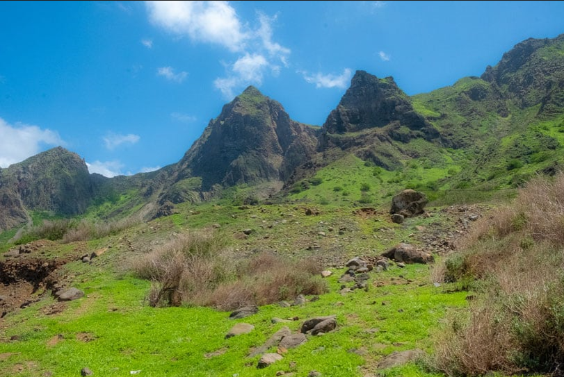
Brava Island, 20 km W of Fogo, is the westernmost of the southern Cape Verde islands. The 10-km-wide island contains 15 morphologically youthful craters located along two or three lineaments intersecting along the crest of the island. The youthfulness of the craters and numerous minor earthquakes in recent years indicate that a significant volcanic hazard still exists (Wolff and Turbeville, 1985). Most of the younger eruptions originated from the interaction of phonolitic magmas with a large groundwater reservoir contained within an older volcanic series characterized by thick welded ignimbrites and block-and-ash flow deposits. Carbonatitic lavas are also found.

Sources: Instituto Nacional de Meteorologia e Geofísica (INMG), Governo de Cabo Verde, GVP.

Photo : paulinaontheroad.


Iceland , Reykjanes  Peninsula :

Deformation and seismicity continue to decrease while an eruption remain possible
If there would be an eruption, the most likely place would be east of Sýlingarfell.
Updated 29. November at 17:00 UTC

The seismic activity has continued to slowly decrease over the last two days. Yesterday, about 340 earthquakes were measured near the magma intrusion in the area east of Sýlingarfell, and since midnight today, around 150 earthquakes have been recorded. Most of the earthquakes have been smaller than magnitude 1.0.

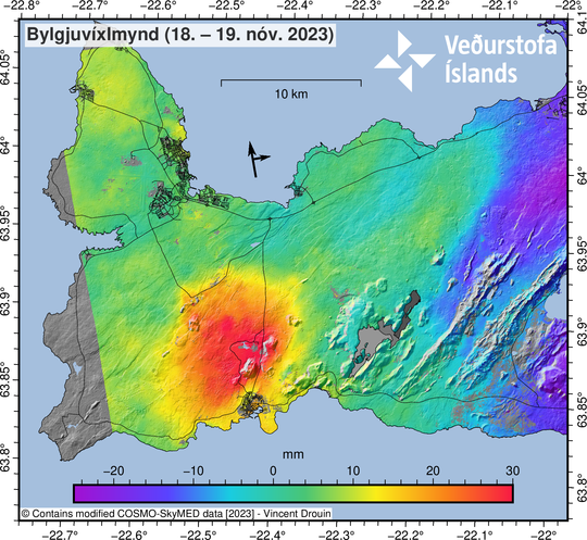
The rate of uplift near Svartsengi has been decreasing, but it is still ongoing at a rate of about 1 cm per day. The majority of the displacement in the region is currently attributed to inflow under Svartsengi with a smaller portion flowing into the magmatic intrusion. In other words, the deformation measured and modeled at Svartsengi is now much greater than that seen near the magma intrusion, but all deformation signals are slowly diminishing. Observed signs of inflow into the magmatic intrusion is now limited to the area east of Sýlingarfell. Despite the slowing down of seismic activity and deformation, an eruption is still considered to be possible. If an eruption does occur, the location thought to be most likely is east of Sýlingarfell.

Source : IMO , GVP


Italy / Sicily , Etna :

Press release on the activity of Etna, November 30, 2023, 05:09 (04:09 UTC).

The National Institute of Geophysics and Volcanology, Osservatorio Etneo, communicates that according to the analysis of images from surveillance cameras, we observe that Strombolian activity continues at the level of the Southeast crater. This activity, variable in intensity and frequency of individual explosions, produces modest emissions of ash which, in accordance with the forecast model, disperse quickly in the east direction and in any case near the summit area.

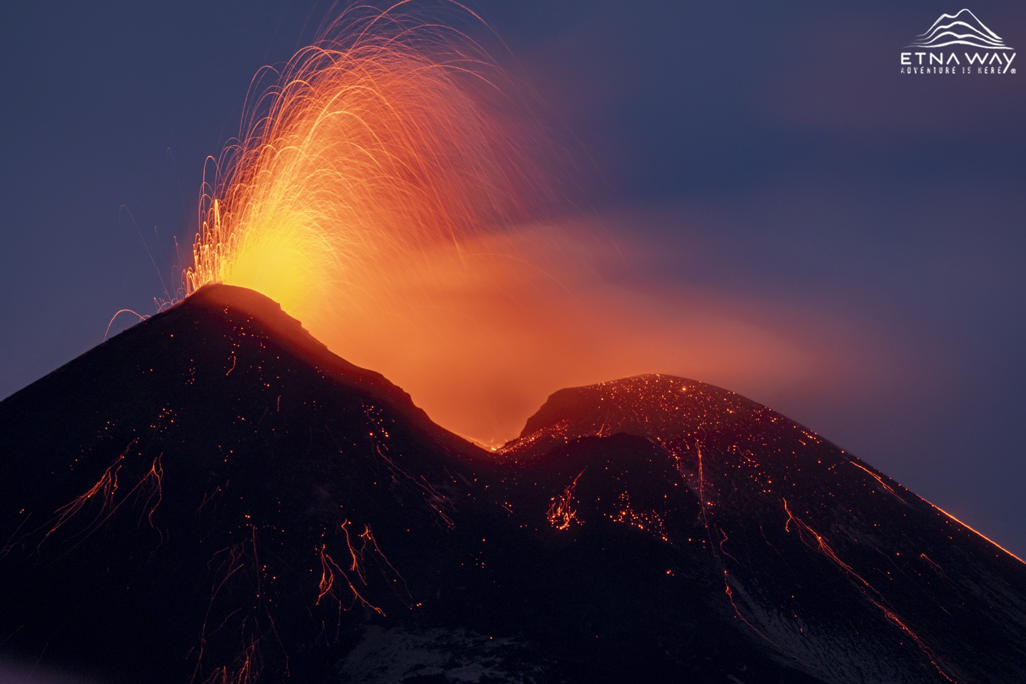
The average amplitude of volcanic tremor continues to show a variable trend over time, with rapid oscillations between medium and high values. The sources remain in the Southeast crater area. Regarding infrasound activity, the sources of the localized events are located in the Southeast crater area and show medium-high intensity. The presence of strong wind does not allow a reliable estimation of the frequency of appearance of infrasound events.
Analysis of the inclinometer network data shows no ground deformation apart from signal oscillations.

Further updates will be communicated shortly.

Source : INGV

Photo : Etnaway


Indonesia , Karangetang :

Reduction of the activity level of Mount Karangetang, North Sulawesi, from level III (SIAGA) to level II (WASPADA).

Visual observation
For the period from November 1 to 28, 2023, the weather is generally clear to cloudy, the mountain is sometimes covered with fog, when it is sunny, smoke from the crater is observed at most 200 m above the summit, the wind is weak to moderate. No visual eruption activity occurred, lava avalanches from the main crater were not observed during the day or night, incandescences were still visible at a maximum of 10 m above the dome. Conditions in the North Crater observed fine to medium white crater smoke with a maximum height of 200 m, at night there was still visible incandescence in the body of the lava dome, no avalanches were observed

Instrumental observation
Seismicity for the period November 1 to 28, 2023 recorded;
5 avalanche earthquakes,
90 emissions earthquakes
68 hybrid/multiple phase earthquakes,
19 deep volcanic earthquakes,
4 local tectonic earthquakes,
2 earthquakes felt on the lI – IV MMI scale
192 deep tectonic earthquakes,
and 1 continuous tremor.

Assessment
Based on visual observation data, the volcanic activity of Mount Karangetang shows a decline. Effusive eruptions identified as lava flows and lava avalanches are no longer observed, however, emissions appear to be increasing, this is due to the release of gas still present. Based on seismicity data, avalanche earthquakes which are an indication of an effusive eruption (lava flow) have decreased. Judging from this fact, the supply of magma has decreased. RSAM data (true seismic amplitude measurement) shows a decrease since November 27, 2023, as well as deformation data (Tiltmeter) seen on the Y axis and the X axis shows deflation, so the activity volcanicity of Mount Karangetang is decreasing. Based on thermal anomaly records detected by Terra and Aqua satellite images on the surface of Karangetang crater, it is shown that the decline has been at a low level since September 2023.
Hot avalanche clouds could occur as the old lava dome is still on top and could collapse/slide at any time with incoming lava. Another feature of the warm clouds that avalanches produce on Mount Karangetang is the accumulation of avalanche lava/landslide material.

Conclusions and Recommendations
Based on the results of the volcanic activity assessment, Mount Karangetang was lowered from Level III (SIAGA) to Level II (WASPADA) effective November 29, 2023 at 4:00 p.m. WITA with recommendations tailored to the threat of potential danger.

Source : PVMBG

Photo : hshdude / esia


Japan , Sakurajima :

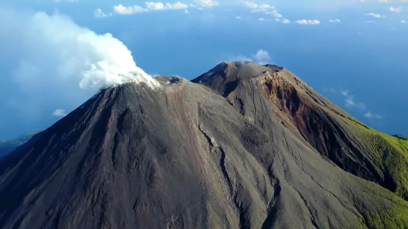
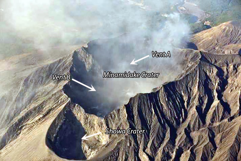
JMA reported ongoing activity at Minamidake Crater (Aira Caldera’s Sakurajima volcano) during 20-27 November, with incandescence at the crater observed nightly. Explosions at 1905 on 20 November and 0226 on 21 November produced ash plumes that rose 1.2 km above the crater rim and drifted SW. Eruptive events on 22 November produced emissions that rose 1 km and drifted N and E. During an overflight of the crater on 24 November plumes obscured views of Minamidake Crater, though observers noted no changes at the geothermal area at Showa Crater. The Alert Level remained at 3 (on a 5-level scale), and the public was warned to stay 2 km away from both craters.

The Aira caldera in the northern half of Kagoshima Bay contains the post-caldera Sakurajima volcano, one of Japan’s most active. Eruption of the voluminous Ito pyroclastic flow accompanied formation of the 17 x 23 km caldera about 22,000 years ago. The smaller Wakamiko caldera was formed during the early Holocene in the NE corner of the caldera, along with several post-caldera cones. The construction of Sakurajima began about 13,000 years ago on the southern rim and built an island that was joined to the Osumi Peninsula during the major explosive and effusive eruption of 1914. Activity at the Kitadake summit cone ended about 4,850 years ago, after which eruptions took place at Minamidake. Frequent eruptions since the 8th century have deposited ash on the city of Kagoshima, located across Kagoshima Bay only 8 km from the summit. The largest recorded eruption took place during 1471-76.

Source : Agence météorologique japonaise (JMA) , GVP

Photo : via INGV.

30 Novembre 2023. FR. Cap Vert : Brava , Islande : Péninsule de Reykjanes , Italie / Sicile : Etna , Indonésie : Karangetang , Japon : Sakurajima .

30 Novembre 2023.


Cap Vert , Brava :

Selon l’Institut national de météorologie et de géophysique du Cap-Vert (INMG), la sismicité sur Brava a augmenté le 30 octobre et est restée élevée. Un tremblement de terre de M 3,6 a été enregistré à 18 h 19 le 30 octobre et a été suivi de huit autres événements de magnitude similaire qui ont été ressentis par les résidents. Un M 4,8 a été enregistré à 21 heures et a été suivi d’un essaim sismique de 48 heures composé principalement d’événements de faible magnitude qui n’ont pas pu être localisés. Le niveau d’alerte a été porté à 2 (le deuxième niveau sur une échelle de cinq niveaux) le 30 octobre.

Le taux de sismicité était variable, avec deux événements toutes les 1 à 10 minutes du 30 octobre au 1er novembre. La plupart des événements se sont produits à des profondeurs de 3 à 4 km ; les hypocentres étaient initialement situés dans la zone de Praia de Águada mais ont ensuite migré vers le centre de l’île. Un tremor harmonique continu est apparu le 9 novembre et a été interprété comme indiquant un mouvement de gaz magmatiques. Le 15 novembre, la sismicité a augmenté et s’est caractérisée par des périodes de tremors volcaniques plus intenses, des événements de longue péride et des événements de type « bouffées » définis comme des événements identiques séparés de quelques secondes. De plus, les habitants ont commencé à ressentir plus souvent les tremblements de terre. Le niveau d’alerte a été porté à 3. Trois tremblements de terre, tous d’une magnitude supérieure à trois, se sont produits les 18 et 19 novembre, et les tremors harmoniques se sont à nouveau intensifiés le 19 novembre.

L’île de Brava, à 20 km à l’Ouest de Fogo, est la plus occidentale des îles du Sud du Cap-Vert. L’île de 10 km de large contient 15 cratères morphologiquement jeunes situés le long de deux ou trois linéaments se croisant le long de la crête de l’île. La jeunesse des cratères et les nombreux tremblements de terre mineurs de ces dernières années indiquent qu’un risque volcanique important existe toujours (Wolff et Turbeville, 1985). La plupart des éruptions plus récentes proviennent de l’interaction de magmas phonolitiques avec un grand réservoir d’eau souterraine contenu dans une série volcanique plus ancienne caractérisée par d’épaisses ignimbrites soudées et des dépôts de blocs et de cendres. On trouve également des laves carbonatiques.

Sources: Instituto Nacional de Meteorologia e Geofísica (INMG), Governo de Cabo Verde, GVP.

Photo : paulinaontheroad.


Islande , Péninsule de Reykjanes :

La déformation et la sismicité continuent de diminuer alors qu’une éruption reste possible. S’il devait y avoir une éruption, l’endroit le plus probable serait à l’Est de Sýlingarfell.
Mise à jour le 29 novembre à 17h00 UTC

L’activité sismique a continué à diminuer lentement au cours des deux derniers jours. Hier, environ 340 tremblements de terre ont été mesurés à proximité de l’intrusion magmatique dans la zone à l’Est de Sýlingarfell, et depuis minuit aujourd’hui, environ 150 tremblements de terre ont été enregistrés. La plupart des séismes ont été inférieurs à une magnitude de 1,0.

Le taux de soulèvement près de Svartsengi a diminué, mais il se poursuit à un rythme d’environ 1 cm par jour. La majorité du déplacement dans la région est actuellement attribuée à l’afflux sous Svartsengi, une plus petite partie s’écoulant dans l’intrusion magmatique. En d’autres termes, la déformation mesurée et modélisée à Svartsengi est désormais bien supérieure à celle observée à proximité de l’intrusion magmatique, mais tous les signaux de déformation diminuent lentement. Les signes observés d’afflux dans l’intrusion magmatique sont désormais limités à la zone à l’Est de Sýlingarfell. Malgré le ralentissement de l’activité sismique et la déformation, une éruption est toujours considérée comme possible. Si une éruption se produit, l’endroit le plus probable se situe à l’Est de Sýlingarfell.

Source : IMO , GVP


Italie / Sicile , Etna :

Communiqué sur l’activité de l’Etna , 30 Novembre 2023 , 05:09 (04:09 UTC) .

L’Institut National de Géophysique et Volcanologie, Osservatorio Etneo, communique que d’après l’analyse des images des caméras de surveillance, on observe que l’activité strombolienne se poursuit au niveau du cratère Sud-Est. Cette activité, variable en intensité et en fréquence des explosions individuelles, produit de modestes émissions de cendres qui, conformément au modèle de prévision, se dispersent rapidement dans la direction Est et en tout cas à proximité de la zone sommitale.

L’amplitude moyenne du tremor volcanique continue de montrer une tendance variable dans le temps, avec des oscillations rapides entre des valeurs moyennes et élevées. Les sources restent dans la zone du cratère Sud-Est. En ce qui concerne l’activité infrasonore, les sources des événements localisés se trouvent dans la zone du cratère Sud-Est et montrent une intensité moyenne-élevée. La présence de vent fort ne permet pas une estimation fiable de la fréquence d’apparition des événements infrasonores.
L’analyse des données du réseau inclinométrique ne montre aucune déformation du sol en dehors des oscillations du signal.

D’autres mises à jour seront communiquées rapidement.

Source : INGV

Photo : Etnaway


Indonésie , Karangetang :

Réduction du niveau d’activité du mont Karangetang, Sulawesi du Nord, du niveau III (SIAGA) au niveau II (WASPADA).

Observation visuelle
Pour la période du 1er au 28 novembre 2023, le temps est généralement clair à nuageux, la montagne est parfois couverte de brouillard, lorsqu’il fait soleil, de la fumée du cratère est observée au maximum à 200 m au-dessus du sommet, le vent est faible à modéré . Aucune activité visuelle d’éruption ne s’est produite, les avalanches de lave du cratère principal n’ont été observées ni de jour ni de nuit, des incandescences étaient encore visibles à un maximum de 10 m au-dessus du dôme. Les conditions dans le cratère Nord ont observé une fumée de cratère blanche fine à moyenne avec une hauteur maximale de 200 m, la nuit il y avait encore une incandescence visible dans le corps du dôme de lave, aucune avalanche n’a été observée

Observation instrumentale
La sismicité pour la période du 1er au 28 novembre 2023 a enregistré ;
5   tremblements de terre d’avalanches,
90  tremblements de terre d’émissions
68 tremblements de terre hybrides/ phases multiples,
19 tremblements de terre volcaniques profonds,
4  tremblements de terre tectoniques locaux,
2 séismes ressentis à l’échelle lI – IV MMI
192 tremblements de terre tectoniques profonds,
et 1 tremor continu .

Évaluation
Sur la base des données d’observation visuelle, l’activité volcanique du mont Karangetang montre un déclin. Les éruptions effusives identifiées comme des coulées de lave et des avalanches de lave ne sont plus observées, cependant, les émissions semblent augmenter, cela est dû à la libération de gaz encore présent. D’après les données de sismicité, les séismes d’avalanche qui sont une indication d’une éruption effusive (coulée de lave) a diminué. À en juger par ce fait, l’apport de magma a diminué. Les données RSAM (mesure d’amplitude sismique réelle) montrent une diminution depuis le 27 novembre 2023, ainsi que les données de déformation (Tiltmeter) vues sur l’axe Y et l’axe X montrent une déflation, de sorte que l’activité volcanique du mont Karangetang diminue. Sur la base des enregistrements d’anomalies thermiques détectés par les images satellites Terra et Aqua à la surface du cratère du Karangetang, il est montré que la baisse est à un niveau bas depuis septembre 2023.
Des nuages ​​chauds d’avalanches pourraient se produire car l’ancien dôme de lave est toujours au sommet et  pourrait s’effondrer/glisser à tout moment avec la lave qui arrive. Une autre caractéristique des nuages ​​chauds que produisent les avalanches sur le mont Karangetang est l’accumulation de matériaux de lave avalancheux/glissement de terrain.

Conclusions et Recommendations
Sur la base des résultats de l’évaluation de l’activité volcanique, le mont Karangetang a été abaissé du niveau III (SIAGA) au niveau II (WASPADA) à compter du 29 novembre 2023 à 16h00 WITA avec des recommandations adaptées à la menace de danger potentiel .

Source : PVMBG

Photo : hshdude / esia


Japon , Sakurajima :

Le JMA a signalé une activité continue dans le cratère Minamidake (volcan Sakurajima ) du 20 au 27 novembre, avec une incandescence dans le cratère observée la nuit. Les explosions à 19 h 05 le 20 novembre et à 02 h 26 le 21 novembre ont produit des panaches de cendres qui se sont élevés à 1,2 km au-dessus du bord du cratère et ont dérivé vers le Sud-Ouest. Les événements éruptifs du 22 novembre ont produit des émissions qui se sont élevées de 1 km et ont dérivé vers le Nord et l’Est. Lors d’un survol du cratère le 24 novembre, des panaches ont obscurci la vue du cratère Minamidake, bien que les observateurs n’aient noté aucun changement dans la zone géothermique du cratère Showa. Le niveau d’alerte est resté à 3 (sur une échelle de 5 niveaux) et le public a été averti de rester à 2 km des deux cratères.

La caldeira d’Aira dans la moitié Nord de la baie de Kagoshima contient le volcan post-caldeira Sakurajima, l’un des plus actifs du Japon. L’éruption de la volumineuse coulée pyroclastique d’Ito a accompagné la formation de la caldeira de 17 x 23 km il y a environ 22 000 ans. La plus petite caldeira de Wakamiko s’est formée au début de l’Holocène dans le coin Nord-Est de la caldeira d’Aira, ainsi que plusieurs cônes post-caldeira. La construction du Sakurajima a commencé il y a environ 13 000 ans sur le bord Sud de la caldeira d’Aira et a construit une île qui a finalement été reliée à la péninsule d’Osumi lors de la grande éruption explosive et effusive de 1914. L’activité du cône du sommet de Kitadake s’est terminée il y a environ 4850 ans, après quoi des éruptions ont eu lieu depuis le Minamidake. De fréquentes éruptions historiques, enregistrées depuis le VIIIe siècle, ont déposé des cendres sur Kagoshima, l’une des plus grandes villes de Kyushu, située de l’autre côté de la baie de Kagoshima à seulement 8 km du sommet. La plus grande éruption historique a eu lieu entre 1471 et 1476.

Source : Agence météorologique japonaise (JMA) , GVP

Photo : via INGV.

October 08 , 2021. EN. Hawaii : Kilauea , Spain / La Palma : Cumbre Vieja , Philippines : Taal, Alaska : Semisopochnoi , Indonesia : Ili Lewotolok .

October 08 , 2021.


Hawaii , Kilauea :

19°25’16 » N 155°17’13 » W,
Summit Elevation 4091 ft (1247 m)
Current Volcano Alert Level: WATCH
Current Aviation Color Code: ORANGE

Activity Summary:  
Kīlauea volcano is erupting. As of this morning, October 7, 2021, lava continues to erupt from two vents; one along the floor and one in the western wall of Halemaʻumaʻu crater. All lava activity is confined within Halemaʻumaʻu crater in Hawai‘i Volcanoes National Park. Seismicity and volcanic gas emission rates remain elevated.

Summit Observations:  
Sulfur dioxide (SO2) emission rates remain high, with a measured emission rate of approximately 7,000 tonnes per day on October 6, 2021. Seismicity remains elevated but stable. Summit tiltmeters continue to record deflationary tilt.

Halemaʻumaʻu Lava Lake Observations:
Lava continues to erupt from two vents within Halemaʻumaʻu crater. Over the past 24 hours, the lava lake level rose approximately 1 meter (3 ft) with a total rise of about 32 meters (105 ft) since lava emerged on September 29. The total thickness of lava filling Halemaʻumaʻu is now 258 meters (846 ft) with a lake surface elevation of approximately 775 meters (2543 ft) above sea level. The west vent continues to have the most vigorous fountain with sustained lava fountain heights of about 12 meters (39 ft). The lava lake is now above the base of the vent and the fountain has built a spatter rampart around most of it. Another vent continues to be active in the southern part of the lake with lava fountain heights averaging 1 meter (3 ft) above the lake surface .

A large crustal submersion event in the ongoing Halema’uma’u crater eruption occurred in the late afternoon on October 6, 2021. This photo was taken from the northwest rim of the crater looking east.

Due to the location of vents, the lava lake is not level across its surface. Areas closer to the vent in the western part are about 2 m (7 ft) higher in elevation compared to the north and south part of the lake and 4 m (7 ft) higher than the east end of the lava lake. Crustal foundering, a process by which cooled lava crust on the lake surface sinks into the hot underlying lake lava, is observed on the active surface of the lava lake. The active lava lake surface is perched 1-2 meters (3-7 ft) above a 20-meter-wide (66 ft) ledge that extends outward to the Halemaʻumaʻu crater wall. The central island and several of the smaller eastern islets from the 2020 lava lake are now visible on the lake surface. All the smaller islets became submerged at the beginning of the eruption, but have gradually emerged since. The central island shows a dark ring marking of cooled lava from partial submersion at the beginning of the eruption.

Source : HVO.

Photos : USGS webcam , USGS/ K. Lynn


Spain / La Palma , Cumbre Vieja : 

A new tongue of lava reaches the sea through the beaches of Los Guirres and El Charcón.

The technical director of the Canary Islands Volcanic Emergency Plan (Pevolca), Miguel Ángel Morcuende, reported this Wednesday after the meeting of the Pevolca expert committee that a new lava tongue has been created and has reached the sea. “At the end of the existing flow, about 350 meters from the coast, there was a fork and the flow ended up flowing between Los Guirres beach and El Charcón. This situation started to be noticed yesterday at 5:00 pm and razed other banana plantations and destroyed several hangars and some buildings, « he explained. In view of this, the volcanologist of the National Geographic Institute, María José Blanco, added that he is « a branch of the main flow that flowed further south », which reached the delta that formed during the eruption of the San Juan volcano. in 1949 between the beach of Los Guirres and the beach of El Charcón. This forced the evacuation of the population as well as emergency scientists and technicians in s the La Bombilla region.


The new lava tongue that separated from the main flow and reached Las Hoyas and El Charcon, destroyed nearly 10 new hectares of green space, which includes houses, water reservoirs and other constructions. , as well as banana trees. In total, the lava flows from the volcano have already affected 431 hectares.

The activity has become more explosive in recent hours. The director of the National Geographical Institute of the Canaries, Maria Jose Blanco, said there has been a deterioration in air quality due to weather conditions and weak wind, making it difficult to dilute the cloud ash and sulfur dioxide. This situation, he said, will continue until Saturday, October 9, and affects the operation of La Palma airport, which closed its activities on Thursday, Aena said.

An earthquake recorded at 12:17 this Thursday of magnitude 4.3 « was felt with an intensity III practically throughout the island ». Blanco explained that over the past 24 hours, the number of earthquakes has increased as well as the maximum magnitude observed, but the seismicity recorded on the island of La Palma continues to be located in the area where it is located. is produced on September 11 and 12, at depths between 10 and 15 kilometers, and also at greater depths. It is precisely the great depths, like the 35 kilometers deep at which this latest 4.3 earthquake occurred, that causes experts to downplay the importance. “At the moment, we have no data that would make us think that a new emission center could appear,” explained Pevolca’s technical director, Miguel Ángel Morcuende, “since no new deformation of the terrain has occurred. is registered, and it still is.

During the day on Wednesday, sulfur dioxide values remained at low levels except for a one-off episode in El Paso and Los Llanos at 10 a.m., explained the director of the National Geographic Institute of Canaries, Maria José Blanco, this Thursday following the meeting of the Canary Islands Volcanic Emergency Plan (Pevolca). Tonight, she continued, « there has been a large increase in sulfur dioxide concentrations at the Tazacorte, Los Llanos and El Paso stations, this being more intense in this increase, where a value Hourly maximum of 667 micrograms / cubic meter was measured at seven in the morning, exceeding the alert threshold set at 500 on two consecutive occasions.

Another earthquake, of magnitude 3.8, is recorded southwest of Villa de Mazo
The National Geographic Institute recorded an earthquake with a magnitude of 3.8 southwest of Villa de Mazo, on the island of La Palma, at a depth of 37 kilometers. The movement took place at 3:26 p.m. in the Canaries and was felt by the population, indicates the IGN in a press release. This Thursday, there were other tremors in the same area, one in 4.3 also southwest of Villa de Mazo, 35 kilometers deep, recorded at 12:17, also felt by the population. This earthquake, the largest since the eruption began on September 19, was followed by three others of magnitude 3.3, 3.4 and 3.3 located northeast of the municipality of Fuencaliente and at a depth which oscillates between 12 and 14 kilometers. To date, there have been over 60 seismic movements on the island.

Sources : IGN , El Pais .

Photos : LMV Volcanology Team , aviaçào tv , La Palma Ahora.com. El Pais.


Philippines , Taal :

PHIVOLCS reported that sulfur dioxide emissions at Taal averaged 8,854 tonnes/day beginning on 27 September, and peaked on 5 October at 25,456 tonnes/day which was the highest ever sulfur dioxide gas flux recorded at the volcano. On 27 September the number of daily volcanic earthquakes significantly decreased. During 27 September-5 October upwelling of hot volcanic fluids in the lake was visible and gas-and-steam plumes rose as high as 3 km above the lake. The report noted that a sudden increase in inflation below Taal Volcano Island was recorded in August. The Volcano Alert Level remained at a 2 (on a scale of 0-5). PHIVOLCS reminded the public that the entire Taal Volcano Island is a Permanent Danger Zone (PDZ) and that boating on Taal Lake was prohibited.

TAAL VOLCANO BULLETIN 08 October 2021 8:00 AM

In the past 24-hour period, the Taal Volcano Network did not detect any volcanic earthquake but a low-level background tremor has persisted since 7 July 2021. Activity at the Main Crater was dominated by upwelling of hot volcanic fluids in its lake which generated plumes 1,200 meters tall that drifted northeast. Sulfur dioxide (SO2) emission averaged 9,635 tonnes/day on 07 October 2021. In addition, vog was observed over Taal Volcano and vicinity. Based on ground deformation parameters from electronic tilt, continuous GPS and InSAR monitoring, Taal Volcano Island has begun inflating in August 2021 while the Taal region continues to undergo very slow extension since 2020.

Sources :  GVP , Phivolcs.

Photo : Rizal M


Alaska , Semisopochnoi :

51°55’44 » N 179°35’52 » E,
Summit Elevation 2625 ft (800 m)
Current Volcano Alert Level: WATCH
Current Aviation Color Code: ORANGE

Seismicity has remained elevated with intermittent bursts of activity and at least two explosions were detected in infrasound data over the past day. No new ash clouds were observed in satellite data and observations by local web cameras have been obscured by clouds.

Small eruptions producing minor ash deposits within the vicinity of the active north crater of Mount Cerberus and ash clouds usually under 10,000 feet above sea level have characterized the recent activity, which shows no signs of abating. Small explosions may continue to occur and could be difficult to detect, especially during poor weather conditions.

Semisopochnoi Island is monitored by local seismic and infrasound sensors, satellite data, web cameras, and remote infrasound and lightning networks.

Source : AVO

Photo : Read, Cyrus /  Alaska Volcano Observatory / U.S. Geological Survey.


Indonesia , Ili Lewotolok :

VOLCANO OBSERVATORY NOTICE FOR AVIATION – VONA

Issued : October 07 , 2021
Volcano : Ili Lewotolok (264230)
Current Aviation Colour Code : ORANGE
Previous Aviation Colour Code : orange
Source : Ili Lewotolok Volcano Observatory
Notice Number : 2021LEW44
Volcano Location : S 08 deg 16 min 19 sec E 123 deg 30 min 18 sec
Area : East Nusa Tenggara, Indonesia
Summit Elevation : 4554 FT (1423 M)

Volcanic Activity Summary :
Eruption with volcanic ash cloud at 09h28 UTC (17h28 local). Eruption and ash emission is not continuing.

Volcanic Cloud Height :
Best estimate of ash-cloud top is around 6474 FT (2023 M) above sea level, may be higher than what can be observed clearly. Source of height data: ground observer.

Other Volcanic Cloud Information :
Ash-cloud moving to West

Remarks :
Seismic activity is characterized by continuous volcanic tectonic earthquake.

Level of activity at level III (Siaga) since November 29, 2020 at 1:00 p.m. WITA.
The last eruption occurred on October 5, 2021, resulting in an eruption column height of 500 m. It is observed that the color of the emission column goes from white to gray.
The volcano was clearly visible until it was covered in fog. The smoke from the crater is white / gray with low to moderate intensity, about 100-600 meters above the summit. The weather is sunny, the wind is weak to strong in the North, West and Northwest. The air temperature is approximately 23.2 to 35.1 ° C. An eruption was observed at a height of 300-500 meters, the color of the smoke was white / gray. The eruption was accompanied by a burst of incandescent lava about 300 meters to the southeast, rumbling and a weak to loud explosion sound.

According to the seismographs of October 7, 2021, it was recorded:
25 earthquake eruptions / explosions
82 emission earthquakes
1 harmonic tremor
84 non-harmonic tremors
1 distant tectonic earthquake
Continuous tremor, amplitude 0.5-1 mm (mainly 0.5 mm)

Sources : Magma Indonésie , PVMBG.

Photo : Archive PVMBG.