
July 03 , 2022.
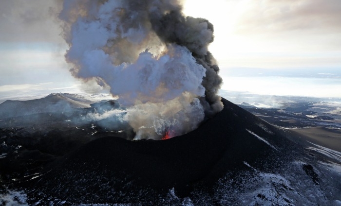
Russia / Kuril Islands , Ebeko :
VOLCANO OBSERVATORY NOTICE FOR AVIATION (VONA)
Issued: July 03 , 2022.
Volcano: Ebeko (CAVW #290380)
Current aviation colour code: ORANGE
Previous aviation colour code: orange
Source: KVERT
Notice Number: 2022-60
Volcano Location: N 50 deg 41 min E 156 deg 0 min
Area: Northern Kuriles, Russia
Summit Elevation: 1156 m (3791.68 ft)
Volcanic Activity Summary:
A moderate eruptive activity of the volcano continues. According to visual data by volcanologists from Severo-Kurilsk, an explosion sent ash up to 3.0 km a.s.l., an ash cloud is drifting to the east of the volcano.
A moderate eruptive activity of the volcano continues. Ash explosions up to 6 km (19,700 ft) a.s.l. could occur at any time. Ongoing activity could affect low-flying aircraft and airport of Severo-Kurilsk.
Volcanic cloud height:
3000 m (9840 ft) AMSL Time and method of ash plume/cloud height determination: 20220703/0007Z – Visual data
Other volcanic cloud information:
Distance of ash plume/cloud of the volcano: 5 km (3 mi)
Direction of drift of ash plume/cloud of the volcano: E / azimuth 90 deg
Time and method of ash plume/cloud determination: 20220703/0007Z – Visual data
Source : Kvert.
Photo : Yuri Demyanchuk.
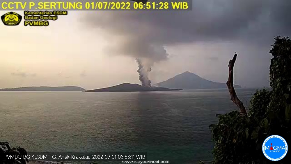
Indonesia : Anak Krakatau :
Mount Anak Krakatau erupted on Friday July 1, 2022 at 06:50 WIB with an ash column height observed at ± 500 m above the summit (± 657 m above sea level). It is observed that the ash column is gray to black with a thick intensity, oriented towards the North-East. This eruption was recorded on a seismograph with a maximum amplitude of 42 mm and a duration of 77 seconds.
CLIMATOLOGY
The weather is cloudy to overcast, the wind is light, oriented to the South-West. The air temperature is around 26-28°C. Humidity 60-80%.
SEISMICITY OBSERVATION
2 emission earthquakes with an amplitude of 39 to 40 mm and a duration of 35 to 55 seconds.
30 low frequency earthquakes with an amplitude of 25 to 45 mm and a duration of 4 to 13 seconds.
1 continuous tremor with an amplitude of 5 to 45 mm, dominant value of 6 mm.
Source : Magma Indonésie.
Hawaii , Kilauea :
19°25’16 » N 155°17’13 » W,
Summit Elevation 4091 ft (1247 m)
Current Volcano Alert Level: WATCH
Current Aviation Color Code: ORANGE
Activity Summary:
The summit eruption of Kīlauea volcano, within Halemaʻumaʻu crater, continued over the past 24 hours. All recent lava activity has been confined to the crater, and current data indicate that this scenario is likely to continue. No significant changes have been noted at the summit or in either rift zone.
Summit Observations:
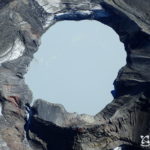
Eruption of lava from the Halemaʻumaʻu western vent into the active lava lake has continued over the past 24 hours, with weak ooze-outs along the northern crater floor. The height of the lave lake rose yesterday but did not become high enough to overflow its banks before stabilizing. Overflight measurements on June 17, 2022, indicated that the crater floor had seen a total rise of about 120 meters (394 feet) .Summit tiltmeters measured inflationary tilt through most of yesterday, consistent with the inflation phase of a summit deflation-inflation (DI) event and ending a DI-event that started on June 24. Tilt turned to slightly deflationary early this morning. A sulfur dioxide (SO2) emission rate of approximately 1,100 tonnes per day (t/d) was measured on June 30, 2022.
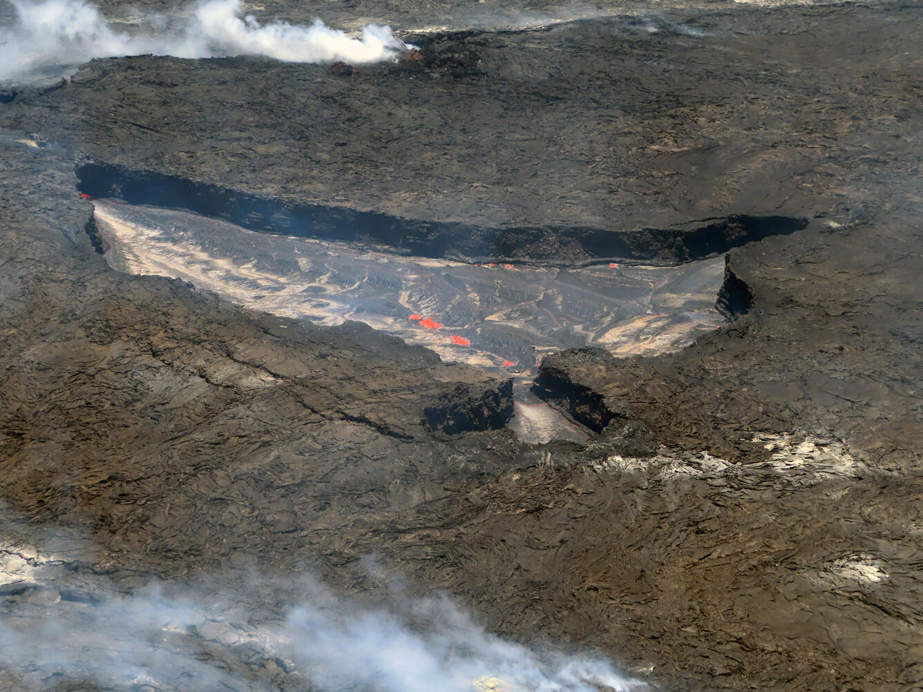
This image shows the active lake surface of Halema‘uma‘u, as seen during a Kīlauea summit eruption observational field shift on June 29, 2022. The lava is flowing from left to right in this photo, and multiple areas of spatter can be seen (the red patches in the center of the photo and along the margin of the lake). The active lake is 23 feet (7 meters) below the rest of the lake surface. The main portion of the lake is 3 feet (1 meter) above the small pinched out section.
Rift Zone Observations:
No unusual activity has been noted along the East Rift Zone or Southwest Rift Zone; steady rates of ground deformation and seismicity continue along both. Measurements from continuous gas monitoring stations downwind of Puʻuʻōʻō in the middle East Rift Zone remain below detection limits for SO2, indicating that SO2 emissions from Puʻuʻōʻō are negligible.
Source : HVO.
Source : USGS / L. Gallant.
La Martinique , Montagne Pelée :
Weekly report on the activity of Mount Pelee for the period from June 24, 2022 to July 01, 2022.
Between June 24, 2022 at 4 p.m. (UTC) and July 01, 2022 at 4 p.m. (UTC), the OVSM no volcano-tectonic earthquake was recorded by the OVSM. However, bad weather conditions disturbed the quality of the data which could explain the absence of detection of low amplitude events.
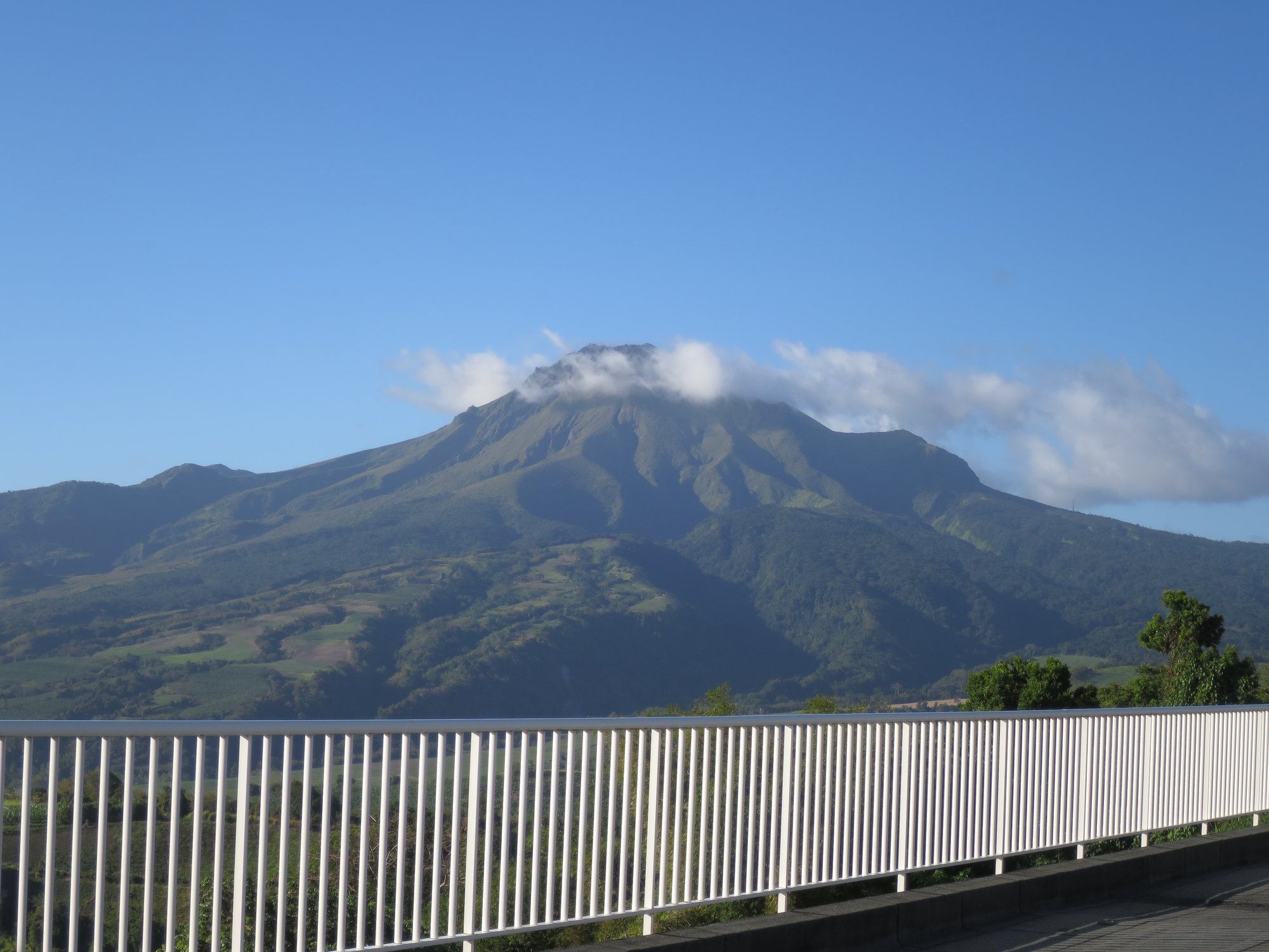
The zone of degassing at sea at shallow depth between St Pierre and le Prêcheur is still observed. The IGP took fluid samples in order to understand the origin of this degassing and to assess its possible relationship with the Mount Pelée hydrothermal system.
An extension of two areas of degraded vegetation located between Morne Plumé and the Chaude River was observed during a helicopter flight carried out on February 9 and May 5, with the support of Dragon 972, and confirmed by analysis of satellite images. and drone (overflight of May 11).
The alert level remains YELLOW: vigilance.
Source et photo : OVSM-IPGP.
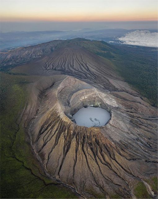
Costa Rica , Turrialba / Poas / Rincon de la Vieja :
Turrialba Volcano
Latitude: 10.025°N; Longitude: 83.767°W;
Altitude: 3340 m above sea level
Current activity level: warning
Possible manifestations: Small eruptions, significant emission of acid gases, temperature rise (incandescence), seismic swarms or volcanic tremor, slight inflation-extension of the volcanic edifice.
The last phreatic eruption occurred on February 27. Seismicity is maintained with a tendency to gradually decrease. The number of high frequency LP type events decreased this week, very few VT type events were recorded, the other seismic parameters remained stable. Geodetic monitoring shows that the Irazú-Turrialba Massif continues to sag and contract. The SO2 flux has a weekly average of 133 +/- 94 t/d.
Poas Volcano
Latitude: 10.2°N; Longitude: 84.233°W;
Altitude: 2780 m above sea level
Current activity level: warning
Possible manifestations: Small eruptions, significant emission of acid gases, increase in temperature (incandescence), seismic swarms or volcanic tremor, slight inflation-extension of the volcanic edifice.
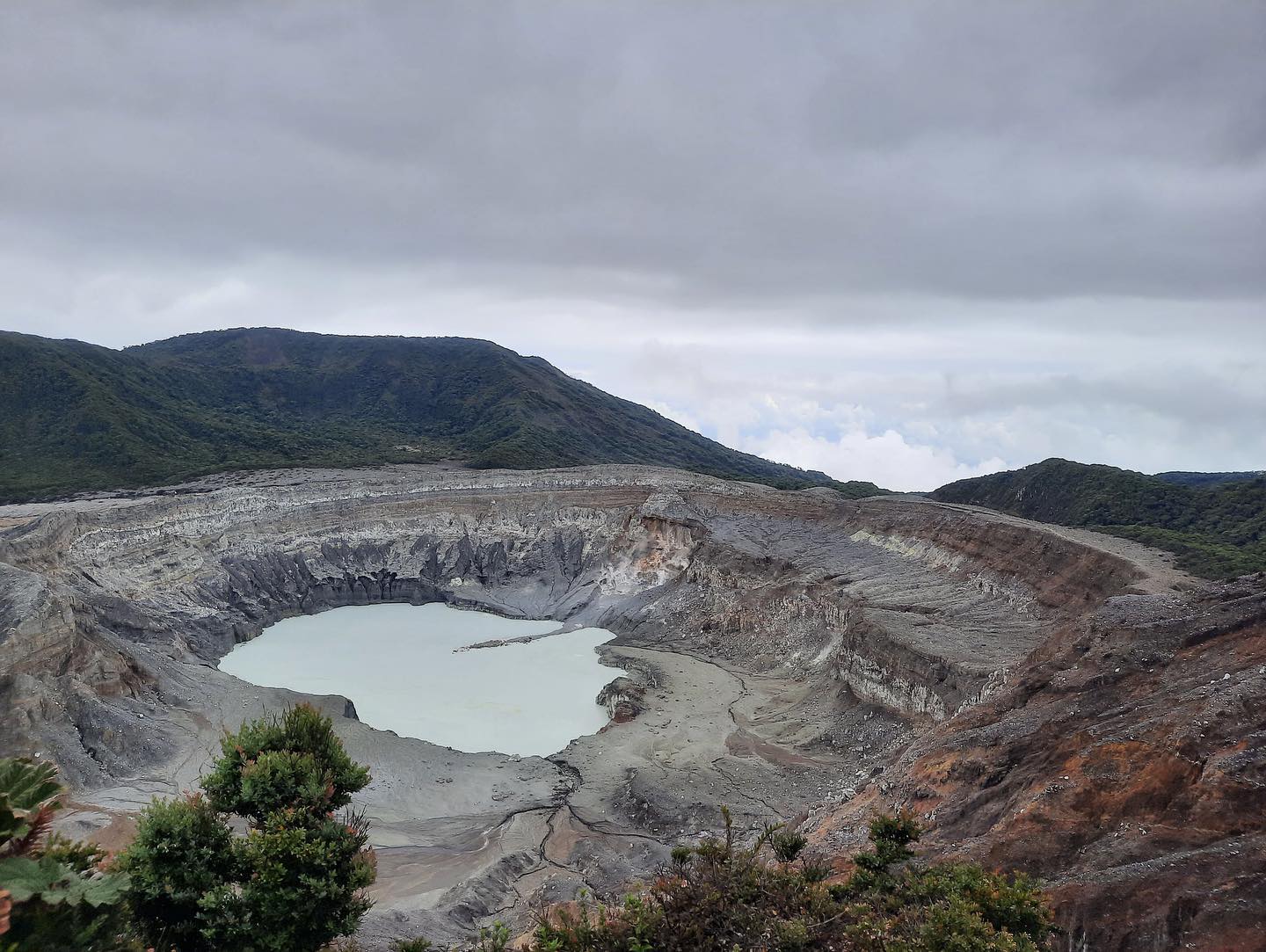
Seismic activity remains comparable to that of last week. The geodetic network shows a slight extension. The SO2/CO2 ratio has a weekly average of 0.22 +/- 0.09
decreases compared to the previous week and the H2S/SO2 ratio has a stable weekly average of 0.02 +/- 0.02. The SO2 flow measured with the DOAS service station has a weekly average of 95 +/- 60 t/d, a value similar to the previous week. The SO2 concentration at the Mirador has exceeded 6 ppm over the past week. The lake level remained stable during the week. Temperatures of up to 93°C have been measured in the East Terrace fumarole field.
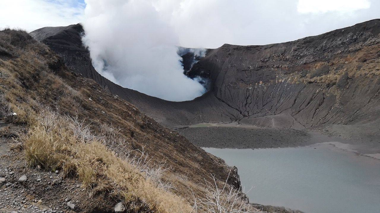
Rincon de la Vieja Volcano
Latitude: 10.83°N; Longitude: 85.324°W;
Altitude: 1895m.
Current activity level: warning
Possible manifestations: Small eruptions, significant emission of acid gases, increase in temperature (incandescence), seismic swarms or volcanic tremor, slight inflation-extension of the volcanic edifice.
The last eruption occurred on June 15. The tremor disappeared and the RSAM calmed down. The number of LP type events and « tornillos » is maintained at a high value. Distal VT-type events were recorded in the Las Pailas area. The fundamental frequency of « tornillo » type events continues to decrease. Geodetic monitoring shows no significant deformation. The SO2 flux shows peaks around 100 t/d.
Source : Ovsicori.
Photos : RSN , New Summit Academy Costa Rica , Soy Tico .


No comment yet, add your voice below!