
June 12 , 2022.
Italy / Sicily , Etna :
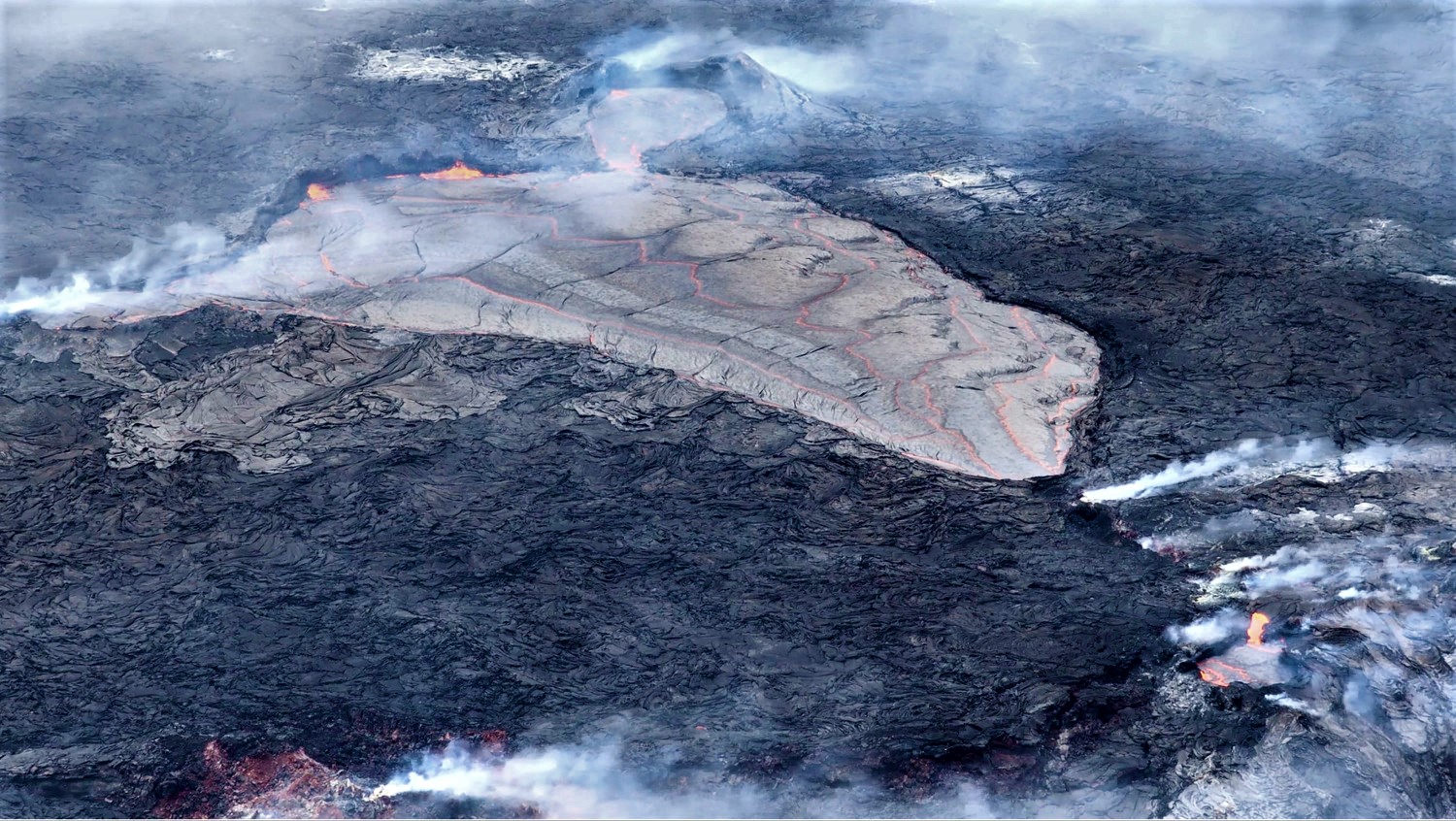
Communication on the activity of Etna, June 11, 2022, 22:00 (20:00 UTC).
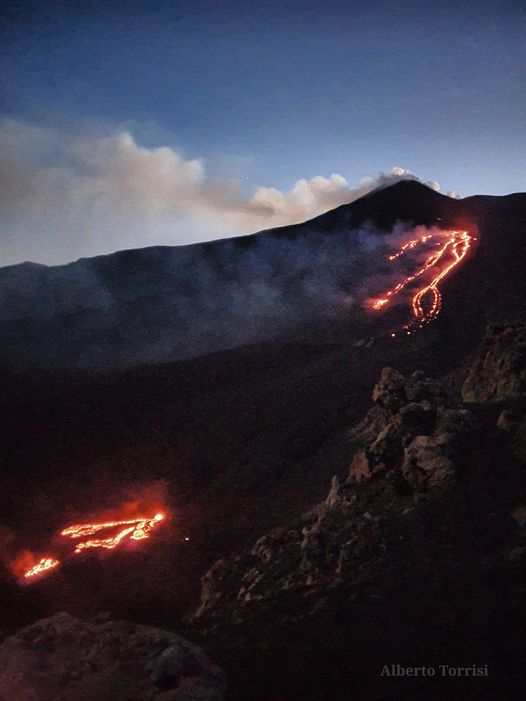
The National Institute of Geophysics and Volcanology, Osservatorio Etneo, announces that the opening of a new effusive vent has occurred at an altitude of approximately 1900 m above sea level near the fracture system located in the North wall of the Valle del Bove in the Serracozzo region where on June 7, an effusive mouth opened. The emitted flow appears poorly fed and the lava flow has extended over a few tens of meters.
During the day, the effusive activity produced by the vent which opened on May 29 at an altitude between 2900 and 2750 m a.s.l. while the explosive activity at the level of the Southeast Crater continued , both with a variable rate.
The average amplitude of the volcanic tremor does not show significant variations; although in the last two days there has been a trend of a gradual and slight increase in its values, they remain within the range of average values. The sources of the tremor are located in the Southeast Crater, at a depth between 2900 and 3000 m above sea level. The infrasound activity is moderate and mainly located in correspondence with the Bocca Nuova crater; however, the strong wind, altering the detection capacity of the network, induces an underestimation of the data collected.
The stations of the inclinometer and GNSS network do not show any significant deformations of the ground.
Further updates will be communicated soon.
Source : INGV
Photo : Alberto Torrisi
Philippines , Bulusan :
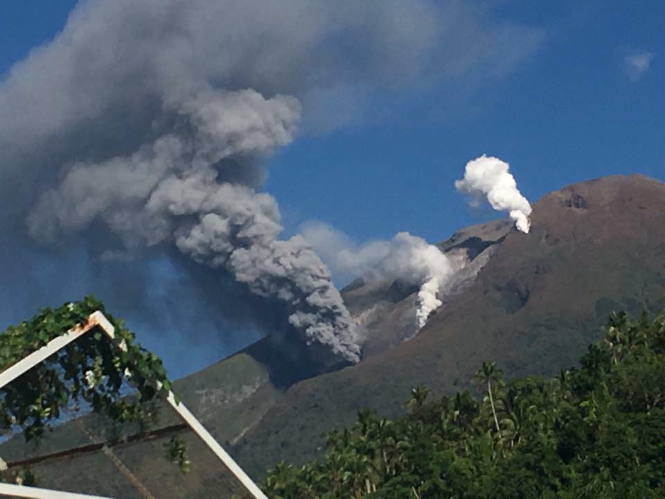
BULUSAN VOLCANO ADVISORY 12 June 2022, 4:20 A.M.
A phreatic eruption was detected by the Bulusan Volcano Network at 3:37 AM this morning. The event lasted 18 minutes based on the seismic record but the eruption plume was not visible in camera monitors.
The public is reminded that Alert Level 1 status prevails over Bulusan Volcano, which means that it is currently in an abnormal condition. Local government units and the public are reminded that entry into the 4-kilometer radius Permanent Danger Zone (PDZ) must be strictly prohibited and that vigilance in the 2-kilometer Extended Danger Zone (EDZ) on the southeast sector must be exercised due to the increased possibilities of sudden and hazardous phreatic eruptions. Civil aviation authorities must also advise pilots to avoid flying close to the volcano’s summit as ash from any sudden phreatic eruption can be hazardous to aircraft. Furthermore, people living within valleys and along river/stream channels especially on the southeast, southwest and northwest sector of the edifice should be vigilant against sediment-laden stream flows and lahars in the event of heavy and prolonged rainfall should phreatic eruption occur.
DOST-PHIVOLCS is closely monitoring Bulusan Volcano’s condition and any new development will be communicated to all concerned stakeholders.
Source et photo ( archive) : Phivolcs.
Chile , Villarica :
Seismology
The seismological activity of the period was characterized by the recording of:
A continuous tremor signal with energy values evaluated from the RSAM between 0.2 and 0.8 um/s, values considered low. This tremor signal had dominant frequencies of 1.1 Hz.
3 VT-type seismic events, associated with rock fracturing (Volcano-Tectonics). The most energetic earthquake presented a value of local magnitude (ML) equal to 1.6, located 9.3 km east-southeast of the volcanic edifice, at a depth of 4.7 km from the crater.
7287 LP type seismic events, associated with fluid dynamics within the volcanic system (Long Period type). In general, this seismicity presented Reduced Displacement values of less than 11 cm2.
The occurrence of an earthquake with DR equal to 50 cm2 that occurred on May 22 stands out. No event had the minimum energy to be localized
335 TR-type seismic events, associated with sustained dynamics over time of fluids within the volcanic system (TRemor). The size of the largest earthquake assessed from the reduced displacement parameter (RD) was equal to 11 cm2. No event presented the minimum energy to be located.
Fluid Geochemistry
Data on sulfur dioxide (SO2) emissions obtained through optical differential absorption spectroscopy (DOAS) equipment, corresponding to the Los Nevados and Tralco stations, installed 10 km to the East-North-East ( ENE) and 6 km east-southeast (ESE) of the active crater, respectively, showed an average value of 260 ± 45 t / d, with a maximum daily value of 715 t / d on May 7. According to the activity of the volcano, these values remain at levels considered low.
No anomalies were reported in the emissions of sulfur dioxide (SO2) into the atmosphere in the area near the volcano, according to data published by the Tropospheric Monitoring Instrument.
Satellite thermal anomalies
During the period, a thermal alert was recorded in the area associated with the volcano on May 16 with a Volcanic Radiative Power (VRP) of 2 MW, a value considered low according to data processed by the Medium Infrared Observation of Volcanic Activity (MIROVA). Through the analysis of Sentinel 2L2A satellite images, 7 radiance anomalies were detected in the area associated with the crater, on May 3, 5, 10, 13, 15, 18 and 25, with a maximum anomalous radiance zone of 6300 m2 on May 15.
Geodesy
According to data provided by 5 GNSS stations installed around the volcanic edifice, displacements of low magnitude were observed, mainly associated with seasonal changes, not showing significant signs of deformation that indicate changes in the dynamics inside. of the volcano.
Surveillance cameras
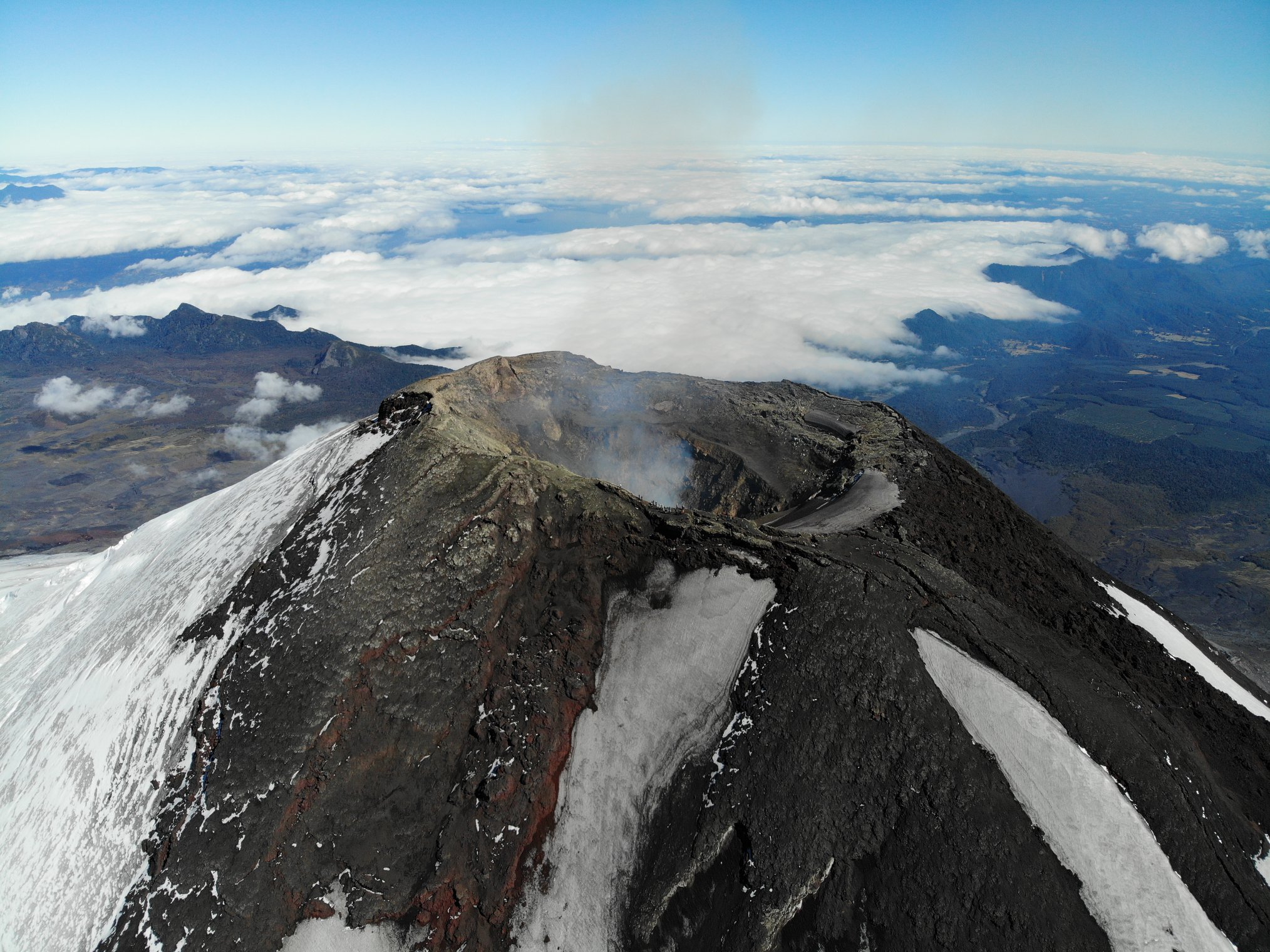
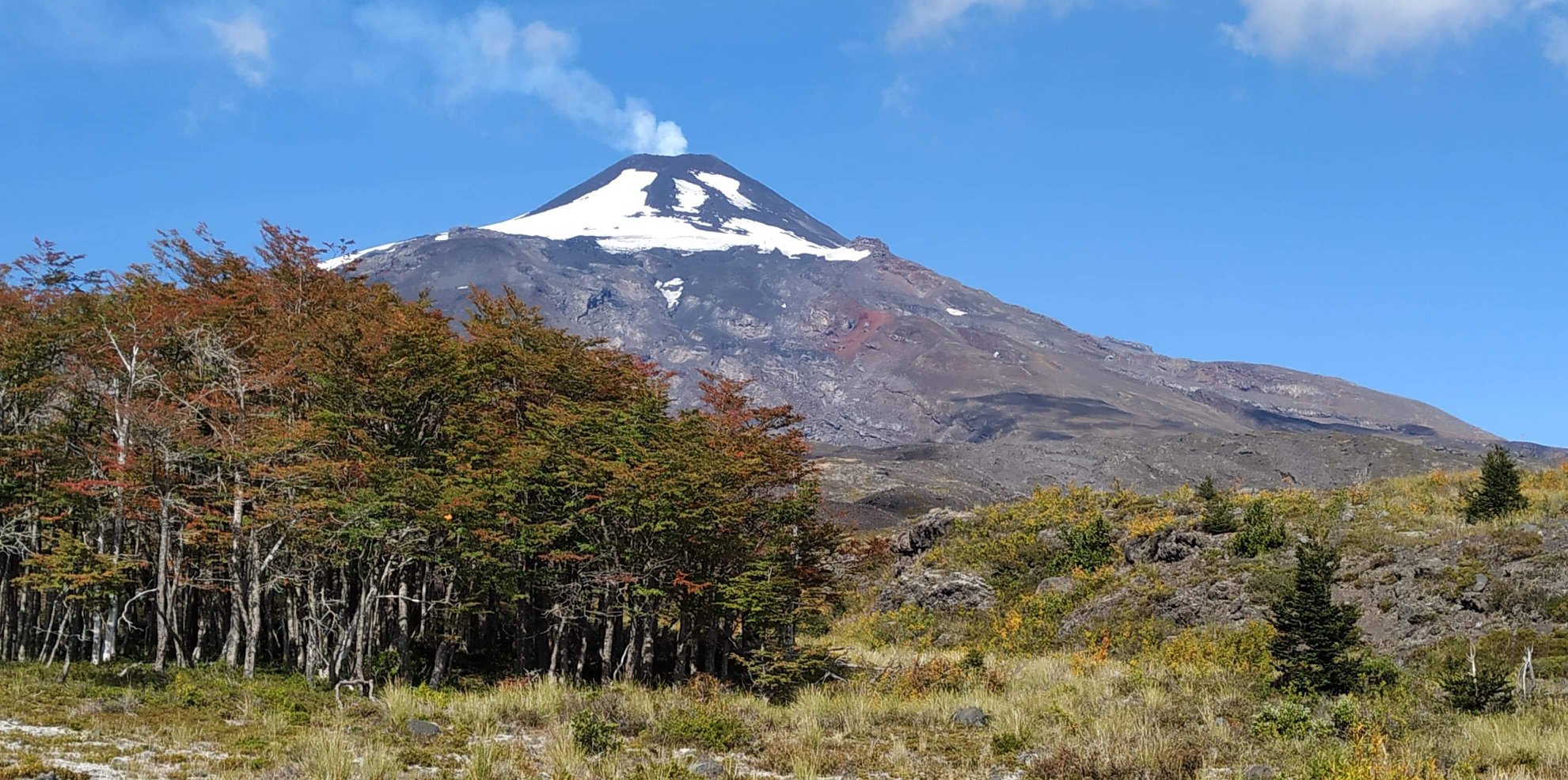
The images provided by the fixed camera installed near the volcano recorded normal degassing, with a maximum column height of 940 meters, on May 10. Since May 25, a continuous record of nocturnal incandescence has been observed.
Activity remained at levels considered low, suggesting stability of the volcanic system.
Observation:
Due to the characteristics of the open conduit of the Villarrica volcano, possible minor explosions could affect a radius of 300 m from the edge of the crater.
The volcanic technical alert is maintained at:
GREEN TECHNICAL ALERT: Active volcano with stable behavior – There is no immediate risk
Source : Sernageomin
Photos : Take a Way ( 2020). Yv’an roue libre: Patagonie .
Hawaii , Kilauea :
19°25’16 » N 155°17’13 » W,
Summit Elevation 4091 ft (1247 m)
Current Volcano Alert Level: WATCH
Current Aviation Color Code: ORANGE
Activity Summary:
The summit eruption of Kīlauea Volcano, within Halemaʻumaʻu crater, continued over the past 24 hours. All recent lava activity has been confined to the crater, and current data indicate that this scenario is likely to continue. No significant changes have been noted at summit or in the East Rift Zone.
Halemaʻumaʻu crater Lava Lake Observations:
Eruption of lava from the Halemaʻumaʻu crater western vent into the active lava lake and ooze-outs onto the crater floor have continued over the past 24 hours. The active lava lake has shown continuous surface activity with lava lake levels stable over the last 24 hours, remaining below overflow. Lava was also flowing from the vent onto the western side of the crater floor this morning. Minor lava ooze-out activity occurred along the edges of the crater floor. Overflight measurements on May 10, 2022 indicated that the crater floor had seen a total rise of about 106 meters (348 feet).
Lava lake activity continues in Halema‘uma‘u, at the summit of Kīlauea Volcano. A small stream of lava was pouring into a small pond northwest of the main lava lake, near the west vent.
Summit Observations:
Summit tiltmeters recorded deflation over the past 24 hours. A sulfur dioxide (SO2) emission rate of approximately 1,900 tonnes per day (t/d) was measured on June 8, 2022.
Source : HVO
Photo : USGS /M. Patrick
Mexico , Popocatepetl :
June 11, 11:00 a.m. (June 11, 4:00 p.m. GMT)
During the last 24 hours, according to the monitoring systems of the Popocatépetl volcano, 36 low intensity exhalations have been detected, accompanied by water vapor, volcanic gases and sometimes a low ash content. In addition, eight minutes of low amplitude tremor were recorded.

During the morning and at the time of this report, a slight emission of water vapor and volcanic gases is observed with a direction in the West-South-West sector.
CENAPRED urges NOT TO APPROACH the volcano and especially the crater, because of the danger of falling ballistic fragments and, in case of heavy rains, to stay away from the bottom of the ravines because of the danger of mudslides and of debris.
The Popocatépetl volcanic alert traffic light is in YELLOW PHASE 2.
Source et photo : Cenapred.


No comment yet, add your voice below!