
June 09 , 2022.
Indonesia , Anak Krakatau :
VOLCANO OBSERVATION NOTICE FOR AVIATION – VONA
Issued: June 08, 2022
Volcano: Anak Krakatau (262000)
Current Aviation Color Code: ORANGE
Previous Aviation Color Code: orange
Source: Anak Krakatau Volcano Observatory
Notification number: 2022KRA45
Volcano location: S 06 deg 06 min 07 sec E 105 deg 25 min 23 sec
Region: Lampung, Indonesia
Summit elevation: 502 FT (157 M).
Volcanic Activity Summary:
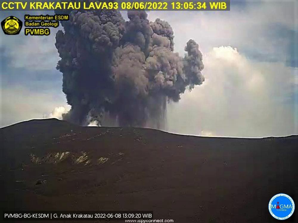
-Eruption with ash clouds at 06:05 UTC (13:05 local time). The eruption lasted 75 seconds.
-Eruption with ash clouds at 4:59 p.m. UTC (11:59 p.m. local time). The eruption lasted 131 seconds.
Volcanic cloud height:
Best estimate of ash cloud top is about 2102 FT (657 M) above sea level, may be higher than can be observed clearly. Source of height data: ground observer.
Other volcanic cloud information:
– Visuals directly from CCTV observed eruption columns with a color of thick black eruption smoke 500m above the summit of the volcano, the wind direction is oriented towards the South.
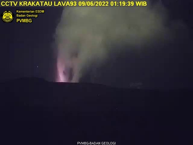
-For the second eruption, an incandescence was observed.
Remarks :
-Eruption recorded on seismogram with a maximum amplitude of 50 mm and a maximum duration of 75 seconds.
-Eruption recorded on seismogram with a maximum amplitude of 55 mm and a maximum duration of 131 seconds.
Source et photo : Magma Indonésie.
Italy , Stromboli / Etna :
WEEKLY BULLETIN STROMBOLI, from May 30, 2022 to June 05, 2022. (issue date June 07, 2022)
ACTIVITY STATUS SUMMARY
In the light of the surveillance data, it is highlighted:
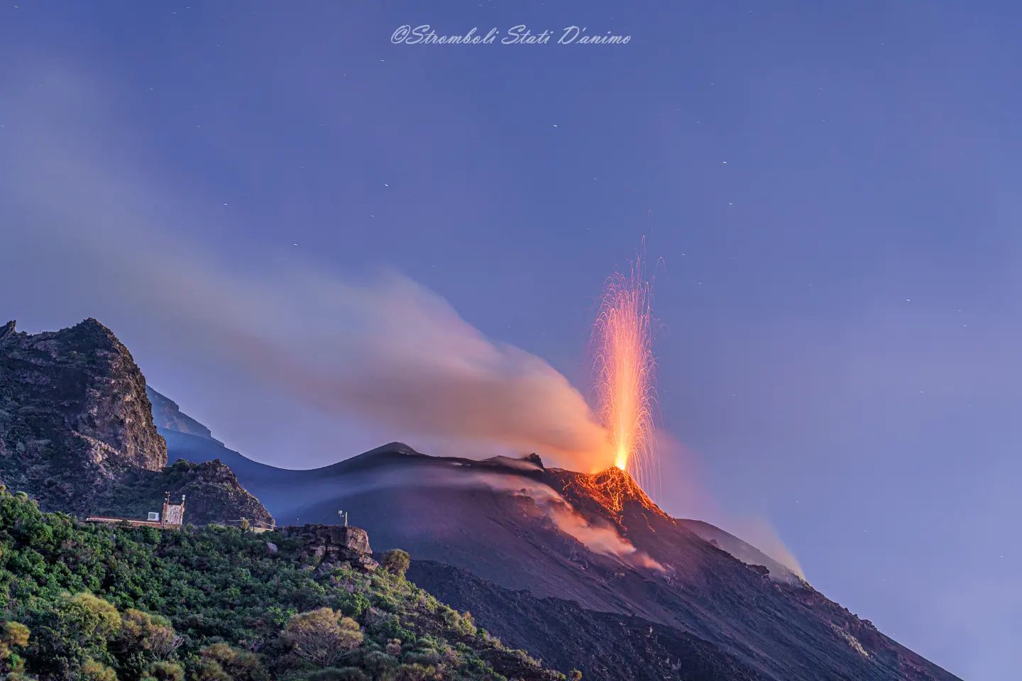
1) VOLCANOLOGICAL OBSERVATIONS: In this period a normal explosive activity of Strombolian type was observed. The total hourly frequency of explosions fluctuated between low values (4 events / h) and medium-low (9 events / h). The intensity of the explosions was medium to high in the North crater area and low in the Center-South crater area.
2) SEISMOLOGY: The seismological parameters monitored do not show any significant variations.
3) GROUND DEFORMATIONS: The island’s ground deformation monitoring networks did not show any significant changes during the week.
4) GEOCHEMISTRY: SO2 flux at an average level
C/S ratio in the plume on average values (C/S = 10.8).
Flux of CO2 on the floor of the crater (Pizzo) on average values (about 8235 g/m2*g).
Isotope ratio of Helium dissolved in the thermal water table at high values (last sample taken on 05/30/2022, R/Ra 4.37).
5) SATELLITE OBSERVATIONS: The thermal activity observed by satellite in the summit area was at a low level.
VOLCANOLOGICAL OBSERVATIONS
During the observation period, the eruptive activity of Stromboli was characterized through the analysis of images recorded by the INGV-OE surveillance cameras (altitude 190m, Punta Corvi, altitude 400m and Pizzo). The explosive activity was mainly produced by 3 (three) eruptive vents located in the North crater area and 1 (one) eruptive vent located in the Center-South crater area. All the mouths are located inside the depression which occupies the terrace of the crater.
Observations of explosive activity captured by surveillance cameras.
Sector N1 located in the area of the North crater produced explosions of low intensity (less than 80 m high) to strong (greater than 150 m high) emitting coarse materials (lapilli and bombs). Sector N2, with three emission points, showed continuous impulsive degassing accompanied occasionally by weak spattering activity. The average frequency of explosions varied between 3 and 5 events/h.
In the Center-South zone, sectors C and S1 did not show significant explosive activity. Sector S2 showed explosions of mostly low intensity (less than 80 m in height) and sometimes medium (less than 150 m) emitting mostly fine materials. The frequency of explosions varied between less than 1 and 4 events/h
Statement on the activity of Etna, June 08, 2022, 15:38 (13:38 UTC).
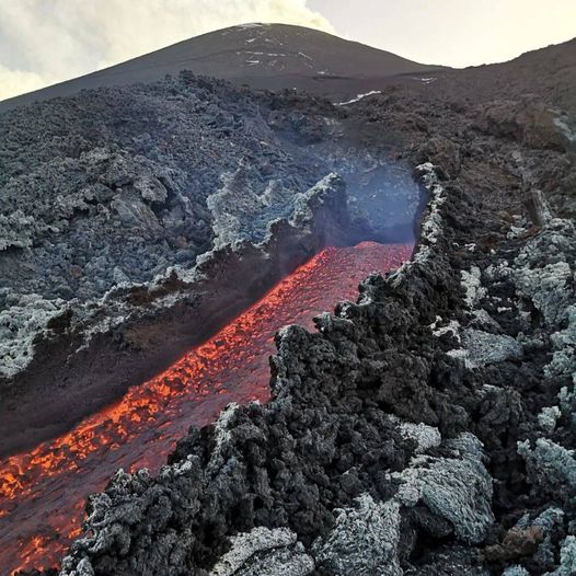
The National Institute of Geophysics and Volcanology, Osservatorio Etneo announces that during the inspection carried out today near the effusive vent which opened in the late afternoon of June 7, 2022, the personnel of the INGV-OE found that the emission point is located at an altitude of 1979 m. The flow is poorly fed and largely cooled and has reached a maximum length of about 170 m. The lava front rises to an altitude of about 1938 m and cools.
On the other hand, the effusive activity of the vents opened on May 29 continues unchanged, between 2900 and 2700 m, with active lava fronts which are located at an altitude between approximately 2000 and 2100 m.
The average amplitude of the volcanic tremor does not show significant variations compared to what was previously reported and oscillates between medium and medium-high values. The sources are located under the Southeast Crater at an altitude of about 2900 m. above sea level.
The infrasound activity is weak, however the strong wind, altering the detection capacity of the network, which induces an underestimation of the data collected.
Data from inclinometer and GNSS networks continue to show the absence of significant deformations in the hours preceding and accompanying the opening and activity of the new eruptive fissure so far.
Further updates will be communicated soon.
Source : INGV.
Photos : Stromboli Stati D’animo , guidevulcanologicheetnanord .
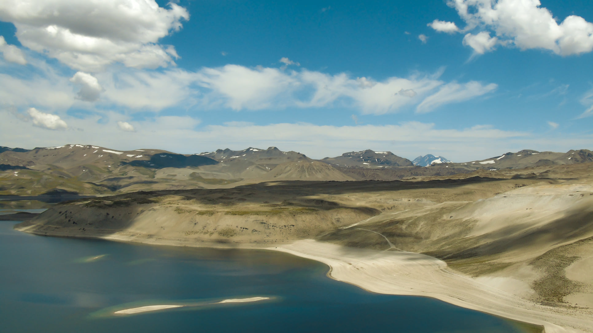
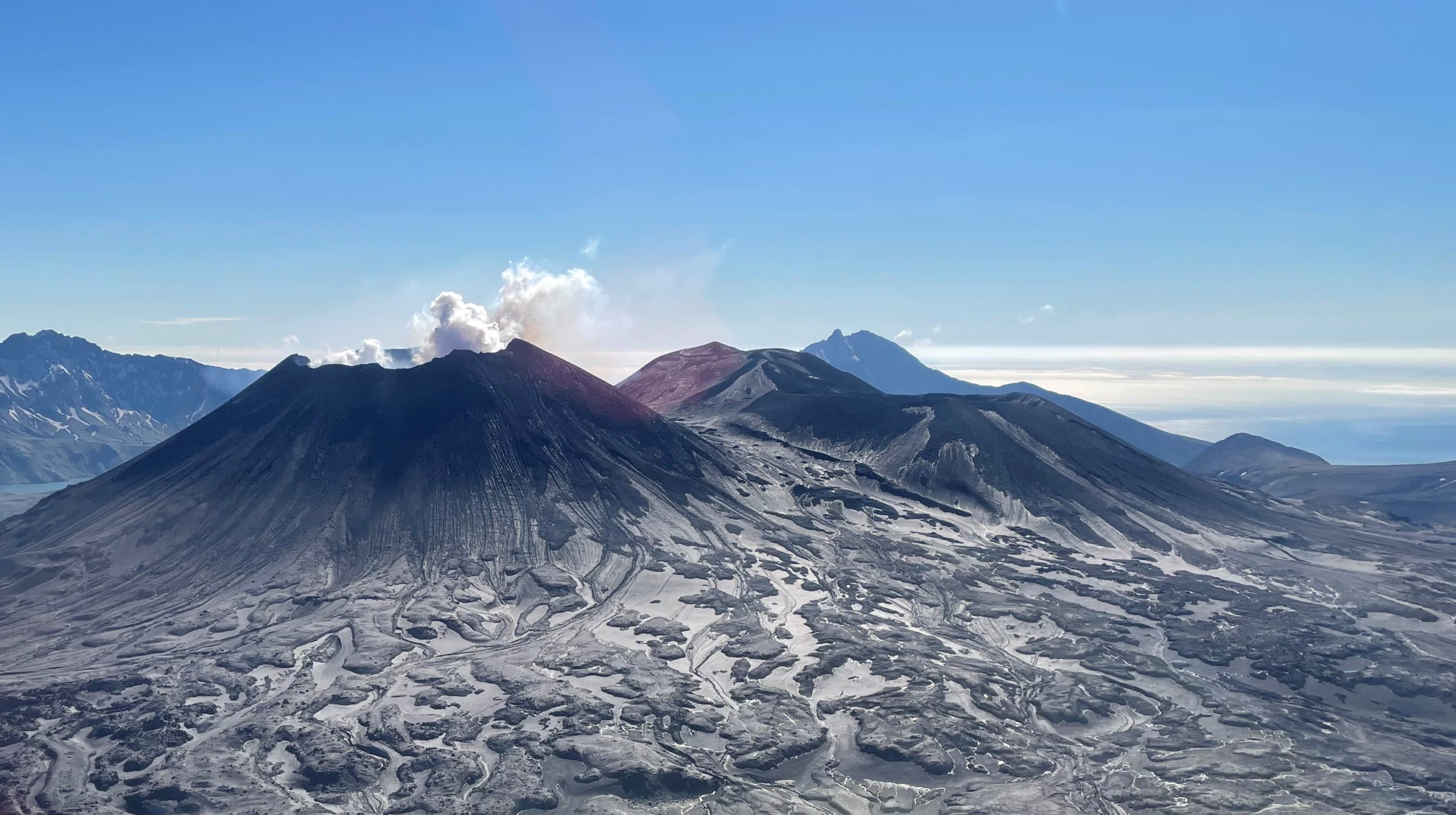
Chile , Laguna del Maule :
Seismology
The seismological activity of the period was characterized by the recording of:
-4,990 VT-type seismic events, associated with rock fracturing (Volcano-Tectonics). The most energetic earthquake presented a value of Local Magnitude (ML) equal to M3.3, located 7.7 km south-south-west of the center of the lagoon, at a depth of 6.6 km with reference to the average height of the lagoon.
-24 LP-type seismic events, associated with fluid dynamics within the volcanic system (Long Period type). The most energetic earthquake presented a reduced displacement value (RD) of 2.9 cm2 and a local magnitude value (ML) equal to M1.2, located 12.4 km west-south-west of the volcanic edifice, at a depth of 25.5 km from the center of the lagoon.
-7 TR-type seismic events, associated with fluid dynamics within the volcanic system (TRemor). The size of the largest earthquake estimated from the reduced displacement parameter (RD) was equal to 8.7 cm2. No event presented the minimum energy to locate
-1 TO (« tornillo ») type seismic event, associated with fluid dynamics within the volcanic system of magnitude (ML) equal to M1.4, located 13.9 km west of the volcanic edifice , at a depth of 13.5 km from the center of the lagoon.
Fluid Geochemistry
No anomalies were reported in the emissions of sulfur dioxide (SO2) into the atmosphere in the area near the volcanic complex.
Geodesy
According to data obtained from the geodetic monitoring network installed in the complex (5 GNSS stations and 4 electronic inclinometers), in addition to satellite radar interferometry, it was observed that the inflationary process monitored since 2012 continues, with slightly lower growth rates than the average recorded last year. For 30 days, the maximum uplift has continued to be recorded at the GNSS MAU2 station, in the southwestern sector of the lagoon, with a rate of 1.9 ± 0.2 cm/month.
Although the volcano-tectonic seismic activity suggests a slight increase in its occurrence and the deformation data remains constant, the other monitoring parameters assessed remain unchanged. Despite the above, a stability of the volcanic system is still envisaged.
The volcanic technical alert is maintained at:
GREEN TECHNICAL ALERT: Active volcano with stable behavior – There is no immediate risk
Source : Sernageomin
Read the article : https://rnvv.sernageomin.cl/rnvv/TI_Santiago_prod/reportes_LB/2022/RAV_20220608_Maule_v5.pdf
Photo : Franco Vera.
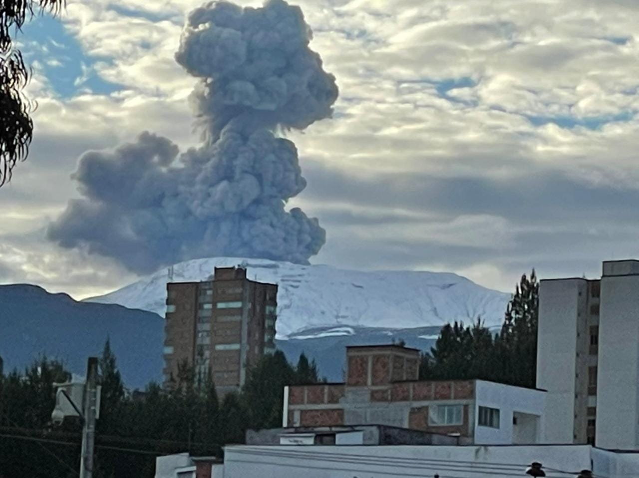
Colombia , Nevado del Ruiz :
Bulletin of activity level of the Nevado del Ruiz volcano.
The activity level continues at the yellow activity level or (III): changes in the behavior of volcanic activity.
Regarding the monitoring of the activity of the Nevado del Ruiz volcano, the COLOMBIAN GEOLOGICAL SERVICE reports that:
Seismicity related to fluid dynamics inside volcanic conduits increased in number of earthquakes and decreased in seismic energy released, compared to the previous week. This seismic activity was characterized by the appearance of continuous volcanic tremors, tremor pulses, long and very long period type earthquakes. In general, these signals exhibited moderate to low energy levels, variable spectral content, and were located primarily within Arenas Crater. Thanks to the cameras installed in the area of the volcano and the report of the officials of the National Natural Park of Los Nevados, the gas and ash emissions associated with some of these signals have been confirmed. Likewise, thanks to the FLIR cameras (Thermographic Cameras) of the volcanic monitoring network, changes in the relative temperature of the emitted material have been observed.
Seismicity associated with rock fracturing maintained similar levels in terms of number of earthquakes and seismic energy released, compared to the previous week. This seismic activity was located mainly in the distal South-West, South-East, North-East, North-West sectors of the volcano and in the Arenas Crater. The depth of the earthquakes varied between 0.5 and 8.5 km. The maximum magnitude recorded during the week was 1.4 ML (Local Magnitude), corresponding to the earthquake that occurred on June 1 at 6:30 p.m. (local time), located 2.4 km southwest of the Arenas crater, at a depth of 3.2 km.
Several episodes of « Drumbeat » type seismicity (drum beat), low energy level and short duration, associated with rock fracturing and fluid seismicity, were recorded on June 02, 03 and 06 .
The Nevado del Ruiz volcano continues at the yellow activity level.
Source : SGC
Read the article : https://www2.sgc.gov.co/Noticias/boletinesDocumentos/Boletin_semanal_de_actividad_del_volcan_Nevado_del_Ruiz_del_31_de_mayo_al_06_de_junio_de_2022.pdf
Photo : Ivan Jaramillo Nicholas.
Alaska , Semisopochnoi :
51°55’44 » N 179°35’52 » E,
Summit Elevation 2625 ft (800 m)
Current Volcano Alert Level: WATCH
Current Aviation Color Code: ORANGE
Low-level eruptive activity continues with minor ash emissions visible continuously in web camera images over the past day during periods of clear weather. These small ash clouds rose hundreds of feet above the vent and quickly dispersed. Periods of seismic tremor continue to be observed.
Small eruptions producing minor ash deposits within the vicinity of the active north crater of Mount Cerberus and ash clouds usually under 10,000 ft (3 km) above sea level have characterized the recent activity. Small explosions and associated ash emissions may continue and could be difficult to detect, especially when thick cloud cover obscures the volcano.
Degassing occurring from the North Cerberus vent of Semisopochnoi Volcano in between ashy eruptive activity. View is from the west. Photo taken during the 2021 Steadfast campaign
Semisopochnoi is monitored by local seismic and infrasound sensors, satellite data, web cameras, and remote infrasound and lightning networks.
AVO reported that low-level eruptive activity at Semisopochnoi’s North Cerberus cone continued during 31 May-6 June. Seismicity remained elevated with intermittent tremor; one explosion was recorded during 31 May-1 June and multiple small explosions were recorded during 4-6 June. Weather clouds mostly prevented satellite and webcam views. Minor ash emissions rising to low heights were visible in webcam images during 6-7 June. The Aviation Color Code remained at Orange and the Volcano Alert Level remained at Watch.
Sources : AVO , GVP , US Geological Survey Alaska Volcano Observatory (AVO)
Photo : Lerner, Allan / Alaska Volcano Observatory / U.S. Geological Survey .


No comment yet, add your voice below!