
May 04 , 2022.
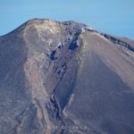
Vanuatu , Gaua (Mount Garet ) :
14°16’0”S 167°30’0”E
Summit 2615ft (797m)
Current Vanuatu Volcano Alert Level: Level 2
Gaua volcano has now increased in the high level of the major unrest state. The Volcanic Alert Level remains at Level 2.
New analyses suggest that this volcano activity is likely to continue at this same level of major unrest (Level 2) or increase to the minor eruption state (Level 3). Volcanic hazards remain on the Gaua volcanic cone (e.g. volcanic gases). The danger zone for life safety is limited on the volcanic cone.
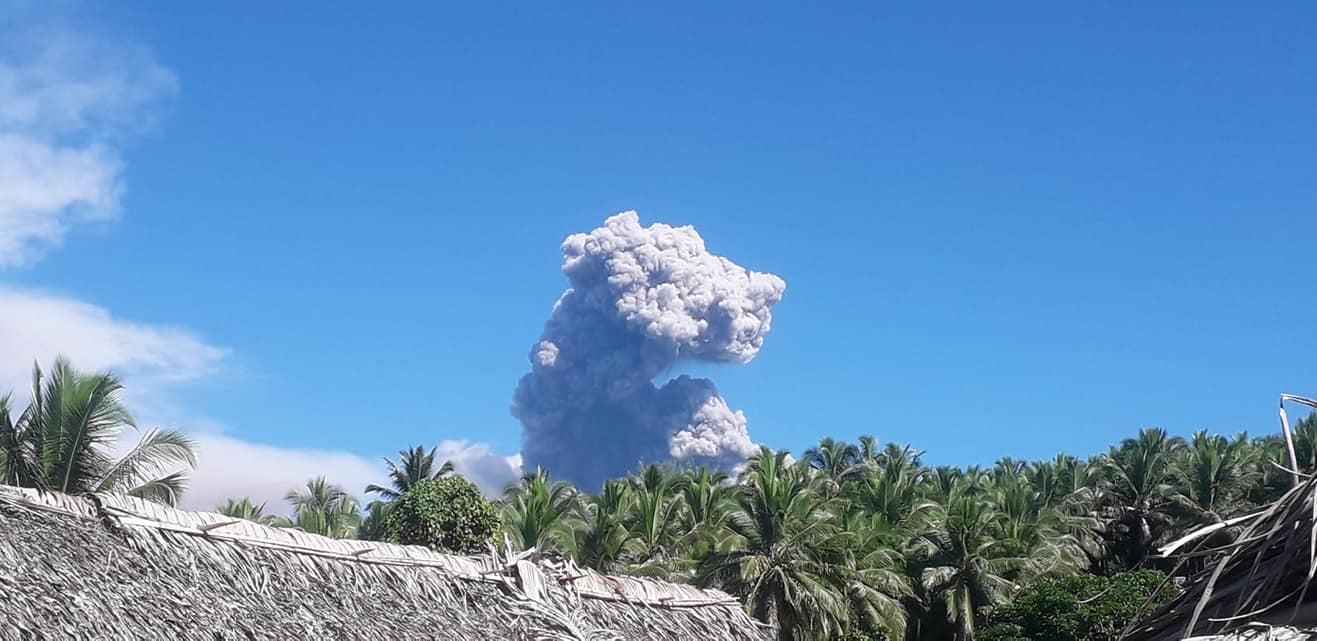
Ground observations and satellite data confirmed that the current activity consists of ongoing volcanic steam cloud which may contain volcanic gases at Mt. Garet. This morning a significant thick ash plume emitted from the vent after a strong heavy sound of explosion that was heard by villagers, especially in Naveto village of North-East Gaua. Visitors will continue to smell volcanic gas while approaching the volcanic cone.
Gaua volcano is one of the active volcano in Vanuatu. Historically, the formation of Mount Garet active cone of and other small cinder cones in the SW part of the caldera has left a crescent-shaped caldera lake, Lake Letas. The symmetrical, flat-topped Mount Garet cone is topped by three active craters.
Source : Geohazard.
Photo : Extrem Pursuit .
Peru , Sabancaya :
Analysis period: from April 25, 2022 to May 01, 2022, Arequipa, May 03, 2022.
Alert level: ORANGE
The Geophysical Institute of Peru (IGP) reports that the eruptive activity of the Sabancaya volcano remains at moderate levels, that is to say with the recording of an average of 40 daily explosions, with columns of ash and of gas up to 2.5 km altitude above the summit of the volcano and their subsequent dispersion. Therefore, for the following days, no significant change is expected in eruptive activity.
The IGP recorded and analyzed the occurrence of 323 earthquakes of volcanic origin, associated with the circulation of magmatic fluids inside the Sabancaya volcano. An average of 40 explosions was recorded daily, in addition to recording Volcano-Tectonic (VT) type events associated with rock fracturing inside the Sabancaya volcano.
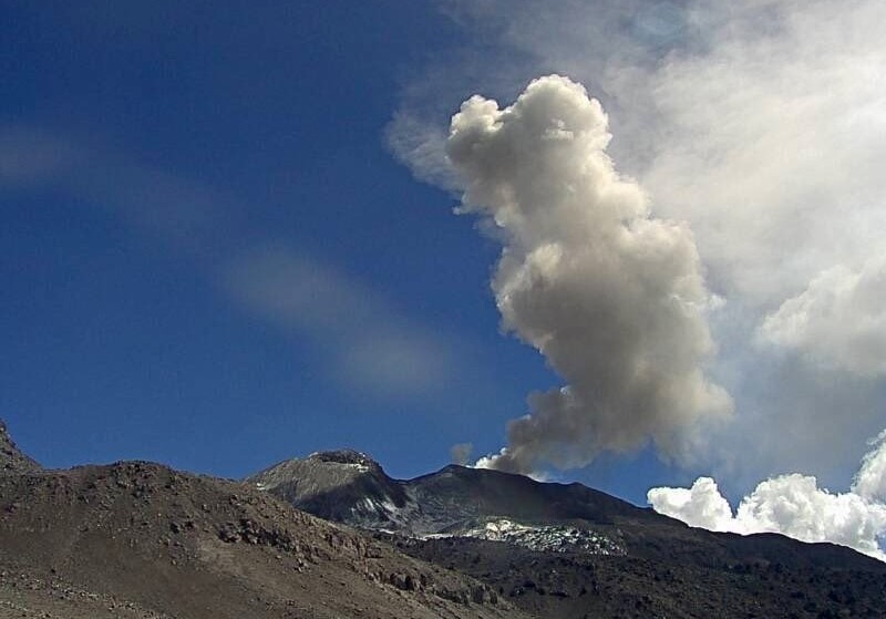
Monitoring the deformation of the volcanic structure using GNSS techniques (processed with fast orbits) does not show any significant anomalies. However, in general, an inflation process has been observed in the northern sector (surroundings of the Hualca Hualca volcano). Visual surveillance identified columns of gas and ash up to 2.5 km above the summit of the volcano, which were scattered towards the western, southeast and southern sectors of Sabancaya. Satellite recordings have identified the presence of 8 thermal anomalies, with a maximum value of 29 MW, associated with the presence of a lava body on the surface of the volcano’s crater.
RECOMMENDATIONS
• Keep the volcanic alert level orange.
• Do not approach within a radius of less than 12 km from the crater.
Source : Cenvul
Photo : Ingemmet .
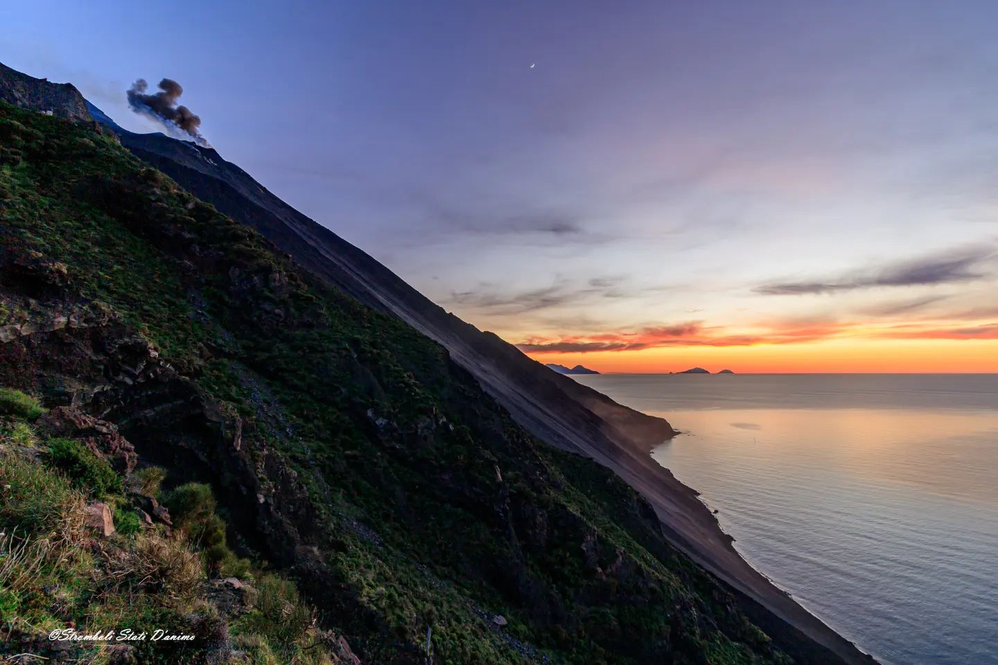
Italy , Stromboli :
WEEKLY BULLETIN, from April 25, 2022 to May 01, 2022, (issue date May 03, 2022)
ACTIVITY STATUS SUMMARY
In the light of the surveillance data, it is highlighted:
1) VOLCANOLOGICAL OBSERVATIONS: In this period a normal explosive activity of Strombolian type was observed. The total hourly frequency of explosions fluctuated between medium-low values (7-9 events/h) with the sole exception of April 30 with medium values (11 events/h). The intensity of the explosions was low in the area of the North crater and variable from low to high in the area of the Center-South crater.
2) SEISMOLOGY: The seismological parameters monitored do not show any significant variations.
3) SOIL DEFORMATIONS: The island’s soil deformation monitoring networks did not show any significant variation.
4) GEOCHEMISTRY: SO2 flux at a medium-low level
CO2 fluxes in the crater area show stable values on average levels.
The C/S value in the plume is at medium levels.
The isotope ratio of helium shows high values (data on April 26, 2022).
5) SATELLITE OBSERVATIONS: The thermal activity observed by satellite was at a low level.
VOLCANOLOGICAL OBSERVATIONS
During the observation period, the eruptive activity of Stromboli was characterized through the analysis of images recorded by the INGV-OE surveillance cameras (altitude 190m, Punta Corvi, altitude 400m and Pizzo). The explosive activity was mainly produced by 3 (three) eruptive vents located in the North crater area and 2 (two) eruptive vents located in the Center-South crater area. All the mouths are located inside the depression which occupies the terrace of the crater.
Due to unfavorable weather conditions, the visibility of the crater terrace on April 26, 2022 was insufficient for a correct description of the eruptive activity.
Sector N1 located in the North crater area produced mainly low intensity explosions (less than 80 m high) emitting coarse materials (lapilli and bombs) mixed with fine materials (ash). Sector N2, with two emission points, showed low intensity explosive activity (less than 80 m in height) emitting coarse materials. The average frequency of explosions varied between 5 and 6 events/h.
In the Center-South zone, sectors C and S1 did not show any significant explosive activity. Sector S2, with two emission points, presented explosions of varying intensity from low to high (the products sometimes reached 250 m in height) emitting coarse materials. The frequency of the explosions varied between 1 and 5 events/h.
Source : INGV.
Photo : Stromboli stati d’animo.
Azores , San Jorge :
SEISMO-VOLCANIC SWARM ON SAN JORGE ISLAND. 03 May 2022.
After a magnitude 2.9 earthquake felt today which appears to have occurred at a depth of 9 km, there has been pressurization with a seismic swarm of several hundred earthquakes in the shape of a deep spasmodic tremor at a depth of about 8-10 km as in La Palma, announcing more pre-eruptive symptoms. We are still at LEVEL V4 and with already more than 30,000 recorded earthquakes.
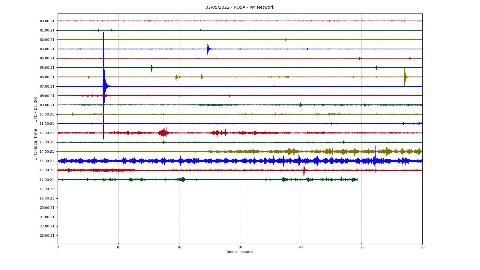
If we look at the accumulated released seismic energy, we see that after an initial release the process has been flat for almost a month, but it hasn’t stopped, it continues to release energy, it is still active and running and may stop or grow, but one clear thing is that it is there ready to manifest. Today is another preview.

The seismic crisis is expected to increase with more intense and frequent earthquakes, with greater release of seismic energy before the eruption, and of course there will be one or more rupture events which will be followed by the appearance of tremor in 24-48h and of course the opening of an eruptive point or an eruption.
Source : Volcanes y Ciencia Hoy .
Indonesia , Ili Lewotolok :
VOLCANO OBSERVATORY NOTICE FOR AVIATION – VONA
Issued : May 04 , 2022
Volcano : Ili Lewotolok (264230)
Current Aviation Colour Code : ORANGE
Previous Aviation Colour Code : orange
Source : Ili Lewotolok Volcano Observatory
Notice Number : 2022LEW12
Volcano Location : S 08 deg 16 min 19 sec E 123 deg 30 min 18 sec
Area : East Nusa Tenggara, Indonesia
Summit Elevation : 4554 FT (1423 M)
Volcanic Activity Summary :
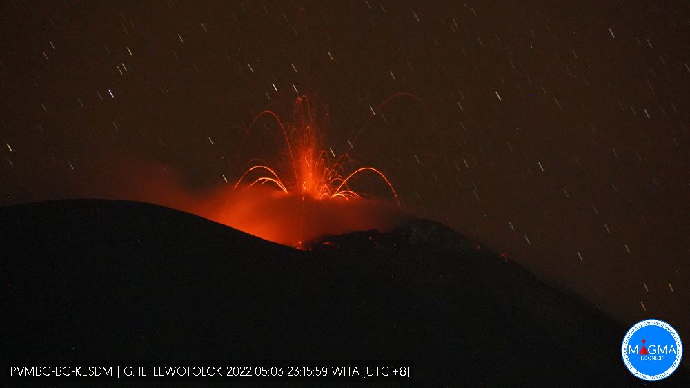
Eruption with volcanic ash cloud at 04h45 UTC (12h45 local). Eruption and ash emission is not continuing.
Volcanic Cloud Height :
Best estimate of ash-cloud top is around 6474 FT (2023 M) above sea level, may be higher than what can be observed clearly. Source of height data: ground observer.
Other Volcanic Cloud Information :
Ash-cloud moving to west.
Remarks :
Seismic activity is Dominated by gas emission and Volcanic tremor earthquake.
Source et Photo : Magma Indonésie.
Ecuador , Reventador :
DAILY REPORT OF THE STATE OF THE REVENTADOR VOLCANO, Tuesday May 03, 2022.
Information Geophysical Institute – EPN.
Surface Activity Level: High, Surface Trend: No change.
Internal activity level: Moderate, Internal trend: No change.
Seismicity: From May 02, 2022, 11:00 a.m. to May 03, 2022, 11:00 a.m.:
Explosion (EXP) 40
Rains / Lahars:
Rains were recorded in the area but no recording of lahars.
Emission / ash column:
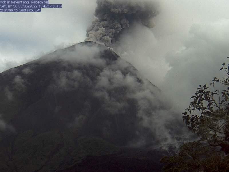
The VAAC agency in Washington reported an emission of ash from a height of 688 meters above sea level in a westerly direction.
Other Monitoring Parameters:
The FIRMS satellite system recorded 5 thermal anomalies in the past 24 hours. The Mirova satellite system recorded 1 moderate thermal anomaly and 1 weak thermal anomaly in the past 24 hours.
Observation:
Yesterday afternoon and night most of the time the volcano was cloudy. Today in the morning, the volcano was clear for a while and it was possible to observe an emission of gas and ash from a height greater than 600 m to the west
Alert level: Orange.
Source : IGEPN
Photos : IGEPN .
Iceland , Reykjanes Peninsula :
Around 1400 earthquakes were detected last week by the IMO’s SIL-seismic network. For the past three weeks detections have gone well over 100 earthquakes and is mostly due to increased earthquake activity in Reykjanes for the past weeks. Around 700 earthquakes have been manually reviewed by the natural hazard specialist on duty at the IMO during the past week. Earthquakes that have not yet been reviewed are mostly located near Þorbjörn and Elvörp on the Reykjanes peninsula.
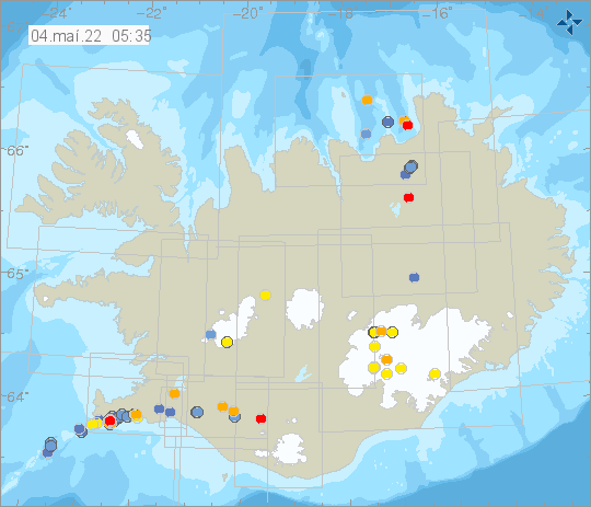
Most activity was distributed on the Reykjanes peninsula but was dense around Þorbjörn, Eldvörp, Sundhnjúkagígar and by Kleifarvatn and Trölladyngja. Other mentionable activity is seismic activity in Öxarfjörður and east of Grímsey, and by Herðubreiðartögl. The largest earthquake of the week was a M3.4 on the 30th of April in South Langjökull and it was felt in Haukadalur. One event was detected in Hekla during the week. Calm weather conditions last week can partly explain the large number of minor earthquakes detected in Reykjanes.
Source : Vedur is


No comment yet, add your voice below!