
April 18 , 2022.
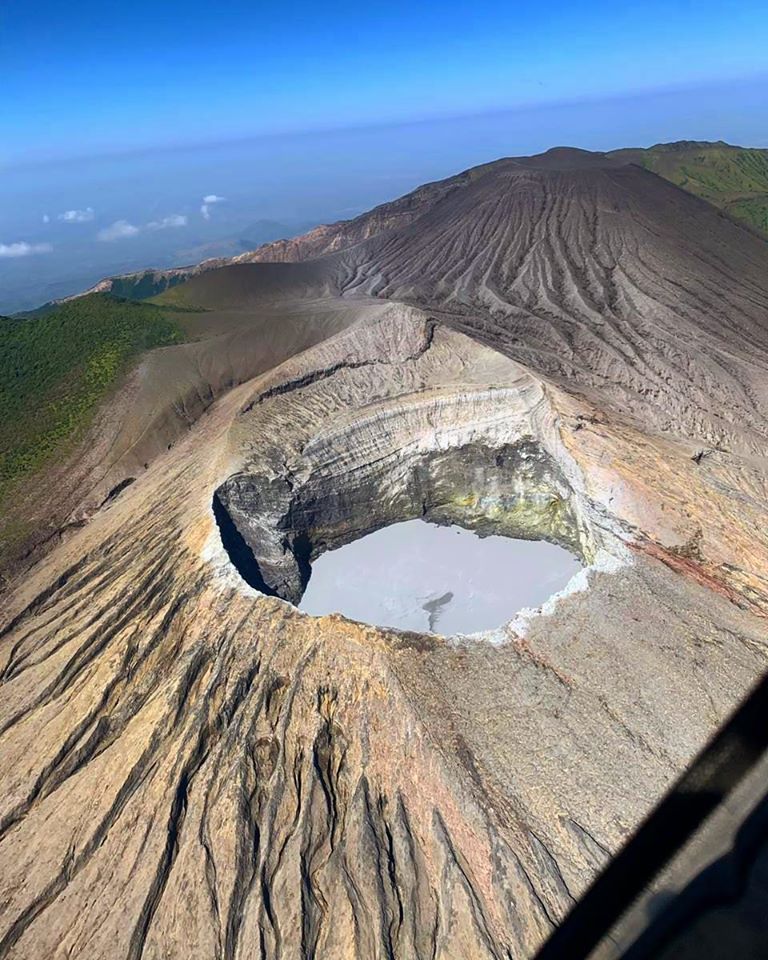
Indonesia , Anak Krakatau :
VOLCANO OBSERVATORY NOTICE FOR AVIATION – VONA
Issued : April 17 , 2022
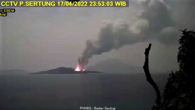
Volcano : Anak Krakatau (262000)
Current Aviation Colour Code : ORANGE
Previous Aviation Colour Code : yellow
Source : Anak Krakatau Volcano Observatory
Notice Number : 2022KRA31
Volcano Location : S 06 deg 06 min 07 sec E 105 deg 25 min 23 sec
Area : Lampung, Indonesia
Summit Elevation : 502 FT (157 M)
Volcanic Activity Summary :
Strombolian eruption with thick ash cloud at 11:30 UTC (18:30 Local) and ash emission is continuning
Volcanic Cloud Height :
Best estimate of ash-cloud top is around 2422 FT (757 M) above sea level, may be higher than what can be observed clearly. Source of height data: ground observer.
Other Volcanic Cloud Information :
Ash-cloud moving to southwest.
Remarks :
Seismic activity is characterized by continuous volcanic tremor
Source : Magma Indonésie.
Photo : PVMBG.
Philippines , Taal :
TAAL VOLCANO BULLETIN 18 April 2022 8:00 AM
In the past 24-hour period, the Taal Volcano Network recorded two (2) volcanic tremor events having durations of two (2) minutes to three (3) hours. Activity at the Main Crater was dominated by the generation of plumes 900 meters tall that drifted southwest. Sulfur dioxide (SO2) emission averaged 155 tonnes/day on 15 April 2022. Temperature highs of 63.7°C were last measured from the Main Crater Lake on 25 February 2022. Based on ground deformation parameters from electronic tilt, continuous GPS, and InSAR monitoring, Taal Volcano Island and the Taal region has begun deflating in October 2021.
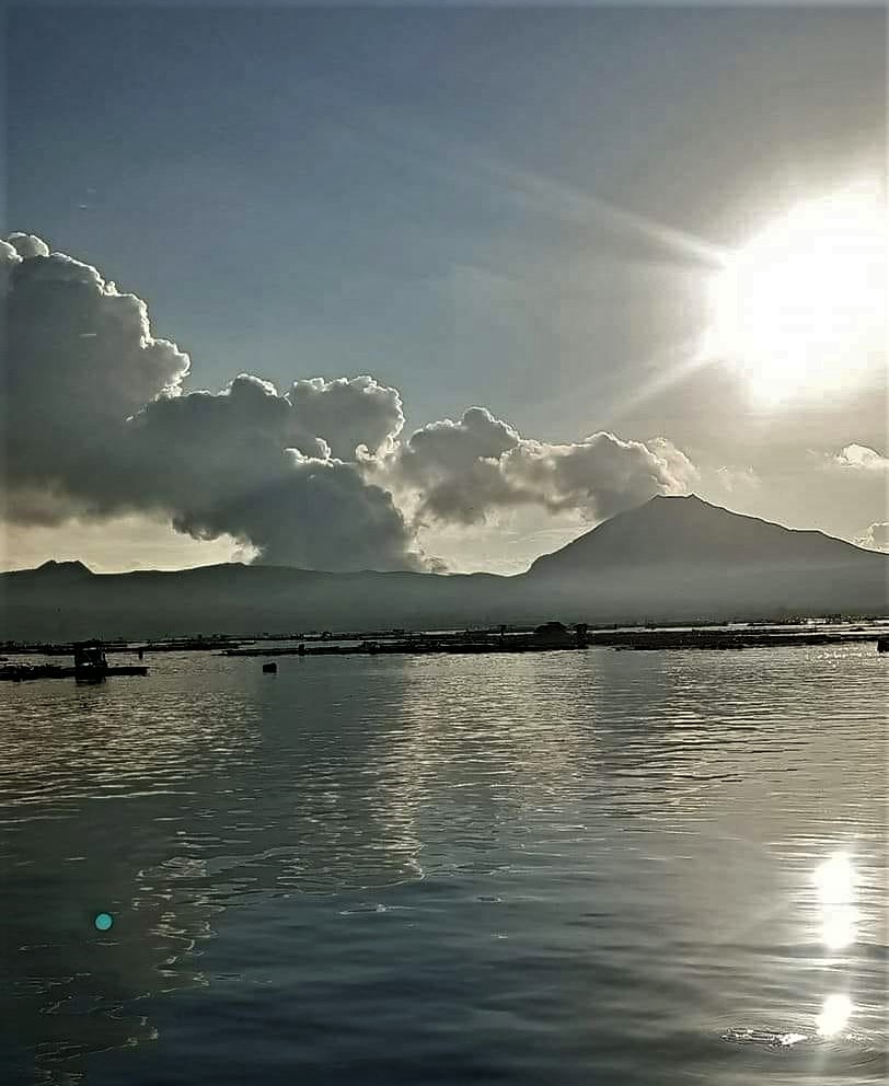
Alert Level 2 (Decreased Unrest) prevails over Taal Volcano. DOST-PHIVOLCS reminds the public that at Alert Level 2, sudden steam-driven or phreatic explosions, volcanic earthquakes, ashfall and lethal accumulations or bursts of volcanic gas can occur and threaten areas within TVI and along its coast. Entry into TVI, Taal’s Permanent Danger Zone, must therefore be strictly prohibited.
Source : Phivolcs.
Photo : Onin casal /Agoncillo ERT.
Iceland , Reykjanes Peninsula :
Just before 9 AM yesterday an earthquake swarm started around 7 km WSW of the Reykjanes peninsula. Two earthquakes above M3 occurred, a M3.2 at 9:27 and M3.5 at 9:34. Number of smaller earthquakes have also been detected. The IMO did not receive felt reports for the largest earthquakes but it is possible that they were felt on the Reykjanes peninsula.
Written by a specialist at 18 Apr 05:15 GMT

Week overview 4 April – 10 April
Just under 600 earthquakes were detected by the IMO¿s SIL-seismic network last week, a similar number as the previus week when 630 earthquakes were located. All earthquakes on land were below a magnitude 3 and most of the activity was located in the Reykjanes peninsula where around 300 earthquakes were located, other activity was distributed in traditional locations. Twenty earthquakes were located around 150 km north of Iceland at Kolbeinsey ridge where the largest earthquakes were roughly a 3 in magnitude.
Source et photo : Vedur is.
Costa Rica , Turrialba / Poas / Rincon de la Vieja / Irazu :
Daily report of the state of volcanoes. OVSICORI-UNA, Date: April 17, 2022, Update at: 13:53:00.
Turrialba Volcano
No eruption reported.
Seismic activity is similar, compared to yesterday.
At the time of this report, the winds are blowing to the northeast.
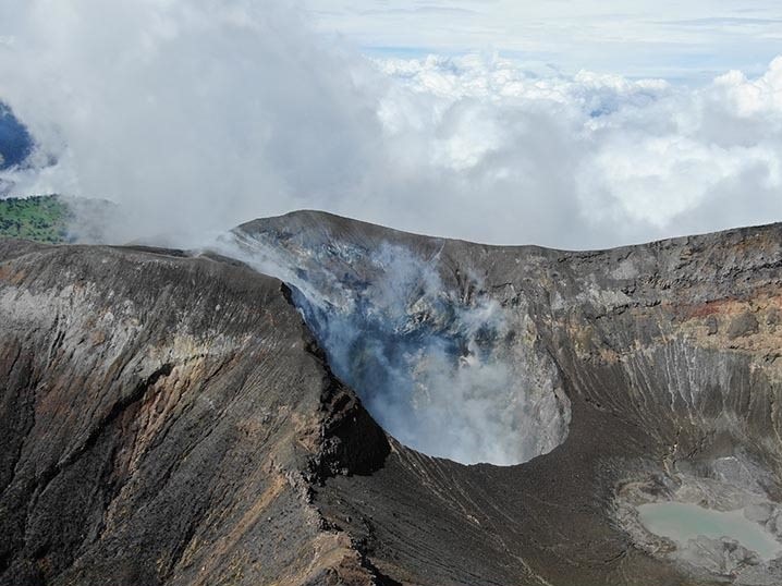
No eruptions recorded. Seismicity remains dominated by frequent low-frequency, low-amplitude LP-type volcanic earthquakes. The concentration of SO2 gas detected in the vicinity of the West crater remains within normal variation values, around 0.5 and 3.4 parts per million, and the ratios of CO2 / SO2 and H2S / SO2 remain stable, around 25 and between 0.13-0.3, respectively. The volcanic edifice experiences a slight extension according to the relative movements detected by the GPS network. Today April 17, 2022 at 10:48 a.m., a volcano-tectonic earthquake of magnitude 2.2 occurred with an epicenter about 0.5 km north of the West crater of the Turrialba volcano. The earthquake was reported and felt by some Turrialba Volcano National Park officials who were near the summit. No change in the behavior of the volcano is observed as a result of this earthquake.
Poas Volcano
No eruption reported.
Seismic activity is similar, compared to yesterday.
At the time of this report the winds are blowing to the southeast.
No eruptions recorded. Since the afternoon of April 11, seismographs have recorded a weak signal of low amplitude tremors with frequencies between 1 and 3.5 Hz. SO2 concentrations show fluctuations within normal detection levels, but generally very low values (MultiGAS SO2 0.3-11 ppm; ExpoGAS SO2 below detection limit. The H2S/SO2 ratio also records very low values around 0.1. The volcanic edifice experiences a slight extension depending on the relative movement detected by the GPS network The subaerial vents of the fumaroles in the eastern sector of the crater and the underwater fumaroles in the hyperacid lake continue to degas water vapor at low temperature.
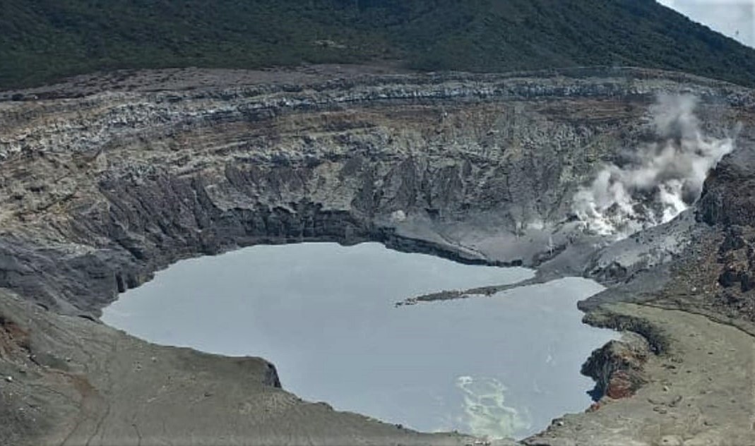
Active convection cells are still observed in the hyperacidic lake and it has retained its milky gray color since the occurrence of the April 6 hydrothermal explosion. Today, April 17, the GRIMM 180 laser dust analyzer and the ThermoScientific 43i SO2 gas analyzer from the OVSICORI-UNA Volcanic Gas and Aerosol Monitoring Station in EMVA-Coronado, have recorded an unusual trend of a slight increase in the concentration of fine aerosols and SO2 in the ambient air of Coronado with a low speed wind blowing from the northwest, i.e. i.e. say from the direction of the Poás volcano, which is the potential source of these aerosols. From 9:35 a.m. until the publication of this report, i.e. for 4 continuous hours, PM10 concentrations of between 8.5 and 17.6 ug/m3 were recorded. The typical daily average is around 6.7 ug/m3 of PM10. Some people have reported respiratory system discomfort such as sneezing, coughing, and difficulty breathing. It is recommended not to exercise and try not to go out in open spaces for people with respiratory problems or allergies. In view of the hydrothermal explosion of April 6, 2022 in the Fumerola Naranja, those visiting the Poás Volcano National Park PNVP are asked to take precautions and follow the recommendations and protocol of the administrators of the PNVP who offer guided tours for security reasons at the point of view for visitors.
Rincon de la Vieja Volcano
No eruption reported.
Seismic activity is similar, compared to yesterday.
At the time of this report, the winds are blowing to the southwest.
No volcanic eruption is recorded. During the past 24 hours, no volcanic tremor has been recorded and seismic activity is at a very low level with signals produced by environmental noise. The volcanic edifice undergoes a slight deflation according to the relative movement detected by the GPS network.
Irazu Volcano
No eruption reported.
Seismic activity is similar, compared to yesterday.
At the time of this report, the winds are blowing to the northeast.

No eruption reported. Seismic activity is similar, compared to yesterday. At the time of this report, the winds are blowing to the northeast. The MultiGAS gas detection system located in the fumarole sector in the upper North-East exterior wall, records CO2 concentrations similar to those observed over time according to our baseline data, ranging between 508 and 527 ppm CO2. The current global level of CO2 in the Earth’s atmosphere is 418 ppm, so the Irazú fumaroles register about 100 ppm above the global atmospheric CO2 level.
Source : Ovsicori.
Photos : G. Avard / Ovsicori , Max Arturo Castillo , Christopher Allen , herediahoy.com .
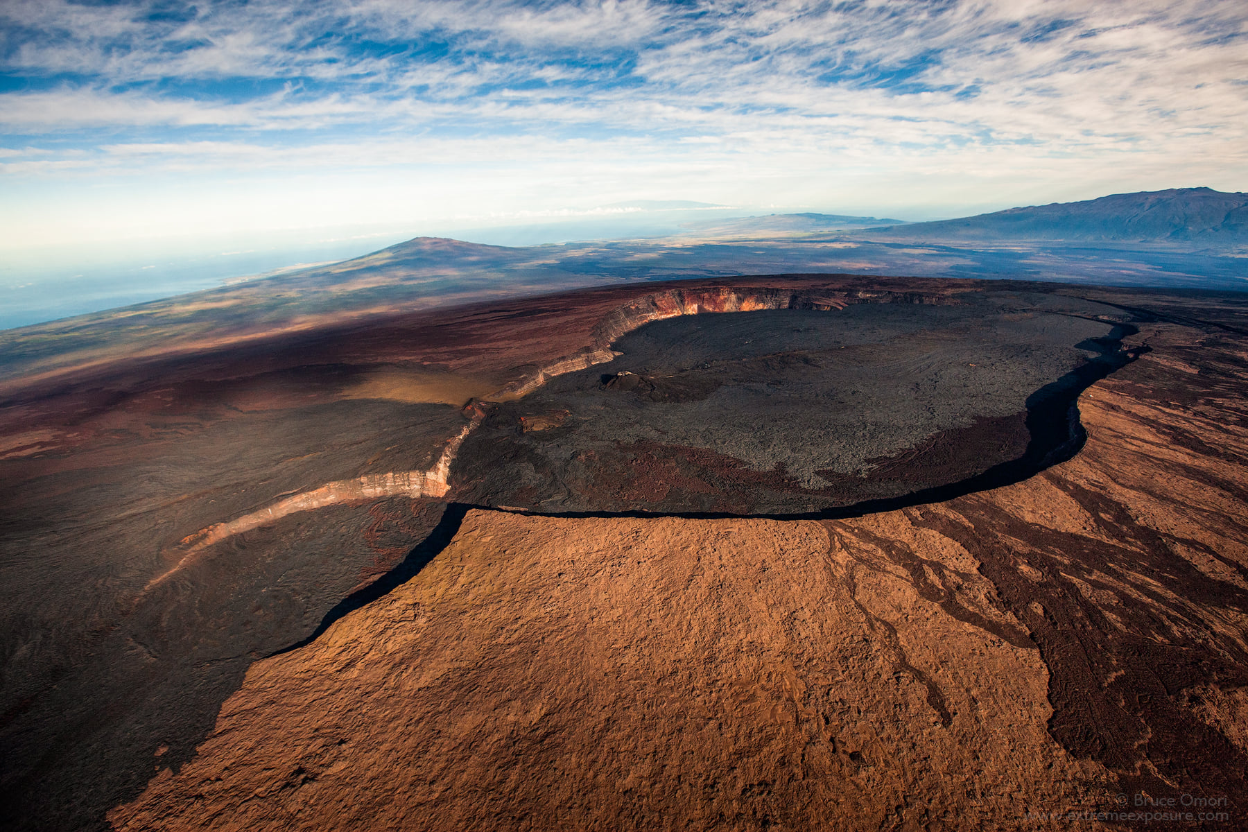
Hawaii , Mauna Loa :
19°28’30 » N 155°36’29 » W,
Summit Elevation 13681 ft (4170 m)
Current Volcano Alert Level: ADVISORY
Current Aviation Color Code: YELLOW
Activity Summary:
Mauna Loa Volcano is not erupting. Rates of seismicity remain slightly elevated above long-term background levels, but have not changed significantly over the past week. Other Mauna Loa monitoring data streams—ground deformation, gas concentrations, visual appearance in webcams—show no significant changes.
Observations :
During the past week, HVO seismometers recorded approximately 44 small-magnitude (below M3.0) earthquakes below the summit and upper-elevation flanks of Mauna Loa. The majority of these earthquakes occurred at shallow depths less than 15 kilometers (9 miles) below sea level.
Global Positioning System (GPS) measurements show low rates of deformation in the volcano’s summit region continuing through the past week.
Concentrations of sulfur dioxide (SO2), hydrogen sulfide (H2S), and carbon dioxide (CO2), as well as fumarole temperatures, remain stable at both the summit and at Sulphur Cone on the upper Southwest Rift Zone.
Webcam views have shown no changes to the volcanic landscape on Mauna Loa over the past week.
Source : HVO
Photo : Bruce Omori .


No comment yet, add your voice below!