
April 02 , 2022.
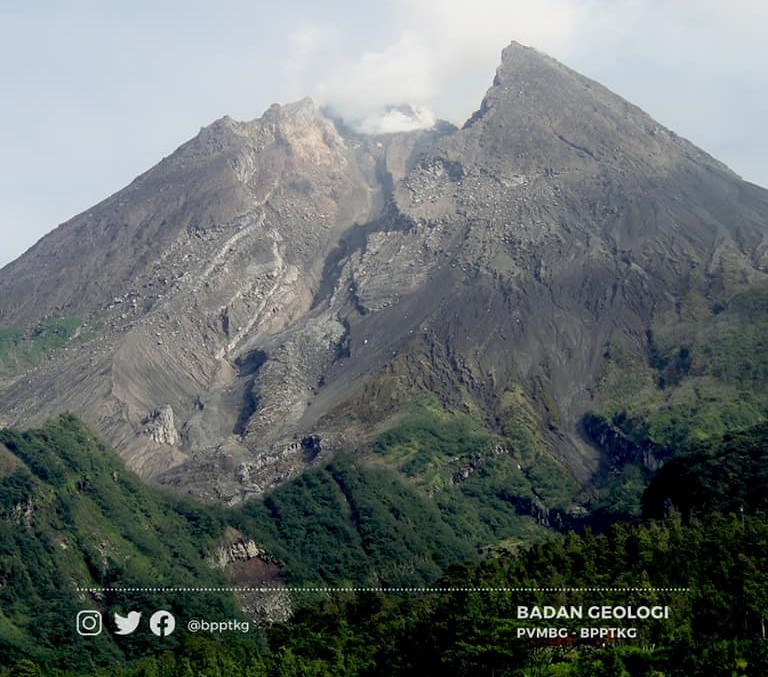
Indonesia , Merapi :
Merapi activity report, from March 25 to 31, 2022.
– This week, there were 2 hot avalanches towards the South-West with a sliding distance of 2,500 m. Lava avalanches were observed 118 times to the southwest, descending the Bebeng River with a maximum slip distance of 2,000 m.
– On the South-West dome we observe that the height increases by about 4 m. For the central dome, no significant morphological change was observed. According to photo analysis, the volume of the Southwest lava dome is 1,672,000 m3 and the central dome is 2,582,000 m3.
Seismicity:
This week, the seismicity of Mount Merapi recorded:
2 hot avalanche earthquakes (APG),
19 shallow volcanic earthquakes (VTB),
70 multi-phase earthquakes (MP),
745 avalanche earthquakes (RF),
10 emission earthquakes (DG),
8 tectonic earthquakes (TT).
The intensity of seismicity this week is still quite high. Mount Merapi’s deformation, which was monitored using EDM this week, showed a distance shortening rate of 0.3 cm/day.
– Rainfall intensity was 39 mm/hour for 85 minutes at Kaliurang post on March 28, 2022 and it was reported that lahars occurred in Senowo River.

Conclusion:
1. The volcanic activity of Mount Merapi is still quite high in the form of effusive eruption activity. The state of the activity is defined at the « SIAGA » level.
2. The current potential danger is lava avalanches and hot clouds in the South-South-West sector covering the Boyong River for a maximum of 5 km, the Bedog River, Krasak, Bebeng for a maximum of 7 km. The Southeast sector covers the Woro River for a maximum of 3 km and the Gendol River for a maximum of 5 km. Meanwhile, the ejection of volcanic material in the event of an explosive eruption can reach a radius of 3 km around the summit.
The public should not carry out any activity in potentially dangerous areas, anticipate disturbances due to volcanic ash from the eruption of Mount Merapi and be aware of the dangers of lahars, especially when it rains around Mount Merapi.
Source : BPPTKG.
Photos : BPPTKG , Oystein Lund Andersen .
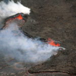
Hawaii , Kilauea :
19°25’16 » N 155°17’13 » W,
Summit Elevation 4091 ft (1247 m)
Current Volcano Alert Level: WATCH
Current Aviation Color Code: ORANGE
Activity Summary:
The summit eruption of Kīlauea Volcano, within Halemaʻumaʻu crater, continued over the past 24 hours. All recent activity has been confined to the crater, and there are no indications of activity migrating elsewhere on Kīlauea.
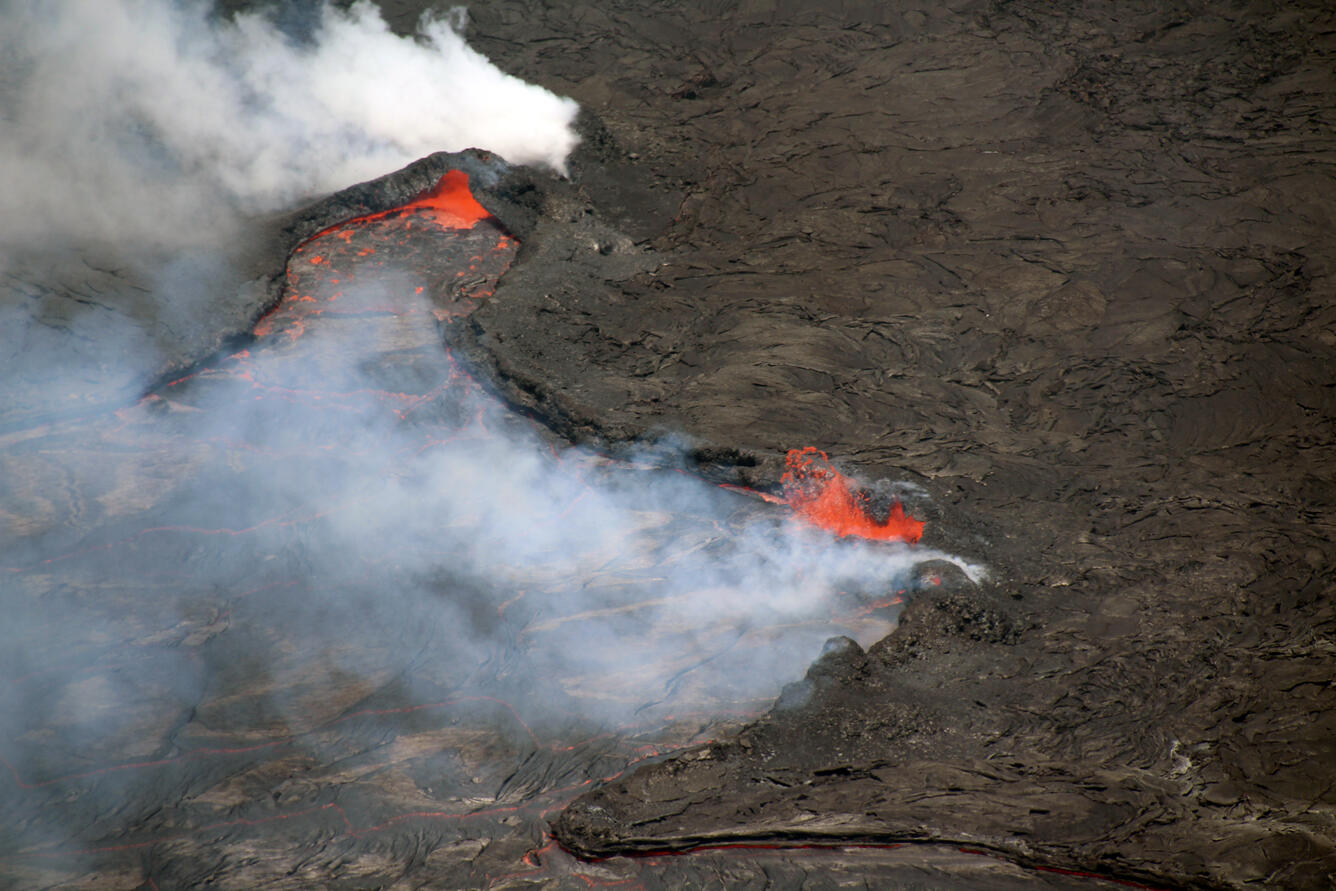
Activity continues within Halema‘uma‘u crater, at the summit of Kīlauea. In this telephoto view looking north, minor spattering is apparent on the eastern (left) margin of the active lava lake area. Lava lake circulation primarily goes from west to east (left to right), and sometimes lava spatters up when it encounters the active lake margin, as shown on this photo.
Halemaʻumaʻu Lava Lake Observations:
Eruption of lava from the western vent into the active lava lake (approximately 2.5% of the crater floor surface) and onto the crater floor continued over the past 24 hours. Numerous and sustained ooze outs along the margins and interior seams of the crater floor continued, and a hornito forming on the eastern side of the lake had a few periods of spattering throughout the day. Since the beginning of this eruption on September 29, 2021, the crater floor has seen a total rise of about 96 meters (315 feet). The volume of lava effused since the beginning of this eruption was approximately 64 million cubic meters (84 million cubic yards or 17 billion gallons) as measured on March 29, 2022.
Summit Observations:
Summit tilt has been stable, with an overall flat trend over the past 24 hours. Volcanic tremor remains above background levels. A sulfur dioxide (SO2) emission rate of approximately 1,400 tonnes per day (t/d) was measured on March 23, 2022.
Source : HVO.
Photo : USGS / N. Deligne
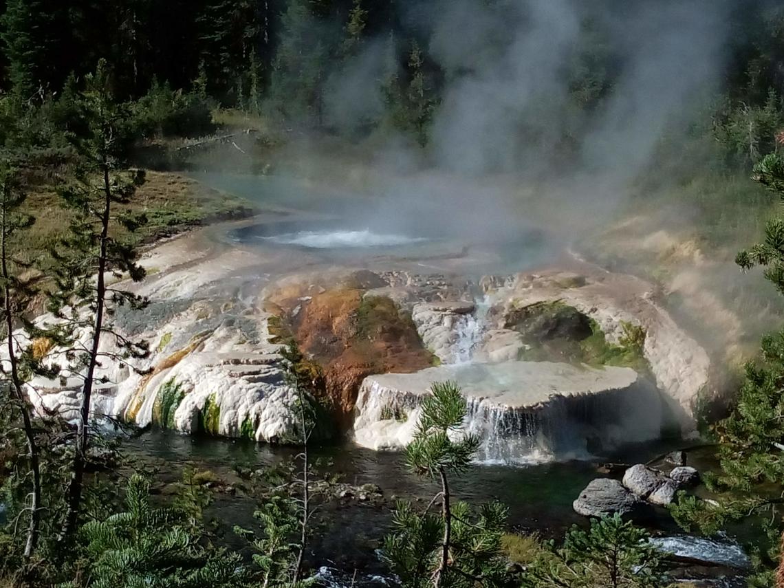
United – States , Yellowstone :
44°25’48 » N 110°40’12 » W,
Summit Elevation 9203 ft (2805 m)
Current Volcano Alert Level: NORMAL
Current Aviation Color Code: GREEN
Recent work and news
Steamboat Geyser continues to be active in 2022, although the frequency of its eruptions has decreased dramatically compared to the preceding 3 years. The geyser experienced two major water eruptions in the past month, on March 4 and March 30. Four major water eruptions have occurred so far in 2022.
Seismicity
During March 2022, the University of Utah Seismograph Stations, responsible for the operation and analysis of the Yellowstone Seismic Network, located 254 earthquakes in the Yellowstone National Park region. The largest event of the month was a minor earthquake of magnitude 2.9 located ~6 miles northeast of Lake in Yellowstone National Park on March 15 at 2:30 PM MDT.
March seismicity in Yellowstone was marked by two swarms:
1) A swarm of 115 earthquakes, ~11 miles northeast of West Yellowstone, MT, began on March 28 and continued through the end of the month. The largest earthquake of the swarm (magnitude 2.6) occurred on March 29 at 12:18 AM MDT.
2) A swarm of 38 earthquakes, ~11 miles south-southeast of West Thumb in Yellowstone National Park. occurred March 2–8, with the largest earthquake (magnitude 2.2) occurring on March 2 at 6:54 PM MST.
Yellowstone earthquake activity remains at background levels.
Ground deformation
No significant changes in ground deformation patterns were observed in data from continuous GPS stations over the past several months. No deformation is apparent in a station near Norris Geyser Basin, and stations within Yellowstone Caldera continue to subside at an overall rate of 2–3 cm (1 in) per year. This subsidence has been ongoing since 2015.
Source : YVO.
Photo : thermal feature , Sara Peek.
Alaska , Pavlof :
55°25’2″ N 161°53’37 » W,
Summit Elevation 8261 ft (2518 m)
Current Volcano Alert Level: WATCH
Current Aviation Color Code: ORANGE
Pavlof Volcano continues to erupt from the east vent near the volcano summit, and occasional small explosions were observed in local infrasound data. Satellite views, though mostly cloudy, recorded elevated surface temperatures throughout the week. A weak gas plume was also seen in webcam and satellite data when views were clear, but no ash emissions were detected. Lava effusion from the east vent was last seen on March 26 and may still be occurring, though perhaps sporadically. Seismicity also remains elevated with near-continuous tremor recorded on the local network.
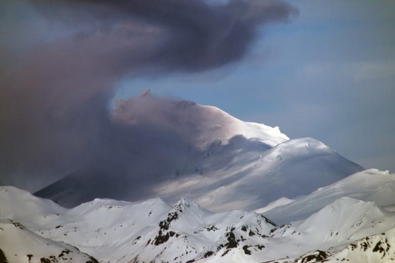
Periods of lava spatter and fountaining from the vent on the volcano upper east flank have been occurring since mid-November 2021. This activity has built a small cone and sent flows down the flank that melt the snow and ice and produce variable amounts of meltwater. The meltwater typically incorporates loose debris on the flank of the volcano and forms thin (less than 2 m thick) lahars. The lahar deposits extend down the east-southeast flank for several kilometers, not quite to the base of the volcano.
Previous eruptions of Pavlof indicate that the level of unrest can change quickly and the progression to more significant eruptive activity can occur with little or no warning.
Pavlof is monitored by local seismic and infrasound sensors, satellite data, web cameras, and remote infrasound and lightning networks.
Source : AVO
Photo : Snapp, Royce.
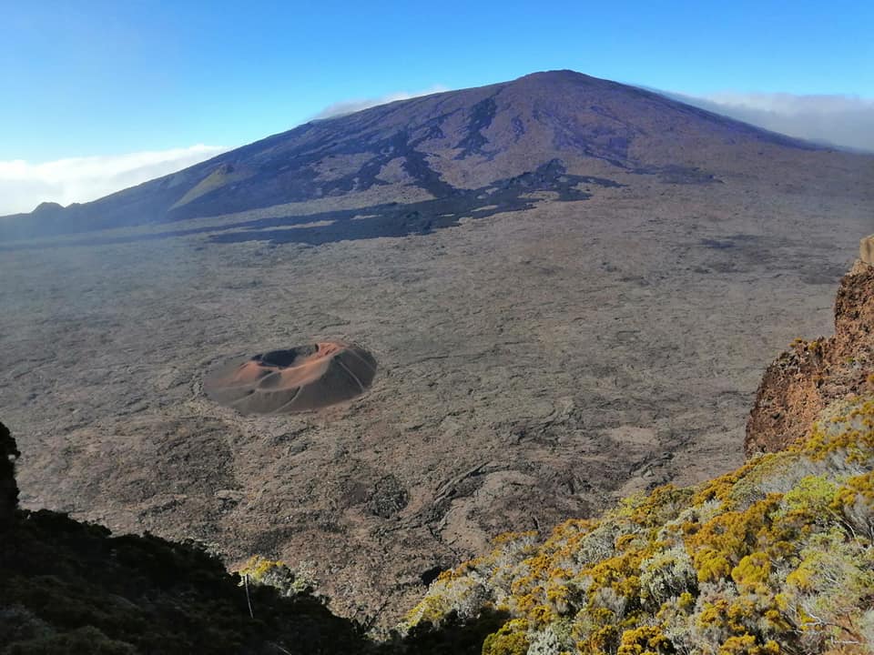
La Réunion , Piton de la Fournaise :
Seismicity
In March 2022, the OVPF recorded in the Piton de la Fournaise massif in total:
• 77 superficial volcano-tectonic earthquakes (0 to 2.5 km above sea level) under the summit craters;
• No deep earthquakes (below sea level);
• 737 collapses (in the Cratère Dolomieu, the ramparts of the Enclos Fouqué and the Piton de Crac, and of the Rivière de l’Est).
Seismicity during the month of March 2022 was up slightly compared to February 2022 with an average of 2.5 superficial volcano-tectonic earthquakes per day against a
average of 2 earthquakes per day in February. Most of these events were located below the eastern rim of the Dolomieu crater.
The month of March was also marked by numerous landslides (in the Cratère Dolomieu, the ramparts of the Enclos Fouqué and the Rivière de l’Est).
Deformation
After the end of the last eruption, on January 17, 2022, a slight recovery in peak inflation was recorded. This, after a slowdown in February, continued throughout the month of March 2022 . This inflation is linked to a pressurization of the superficial magmatic reservoir located about 1.5-2 km deep.
Geochemistry of gases / CO2 concentration in the soil
Following the eruption of December 2020, a continuous increase in CO2 emissions from the ground was recorded at the level of the distal sites (Plaine des Cafres sectors) but also proximal (Gîte du volcan).
At remote sites, a reversal of trends (decline in CO2 emissions) occurred on February 12, 2021, witnessing a possible transfer of magma to more superficial crustal levels.
Source : OVPF.
Read the full article : https://www.ipgp.fr/sites/default/files/ovpf_20220401_bullmensu.pdf
Photo : Nath Duverlie
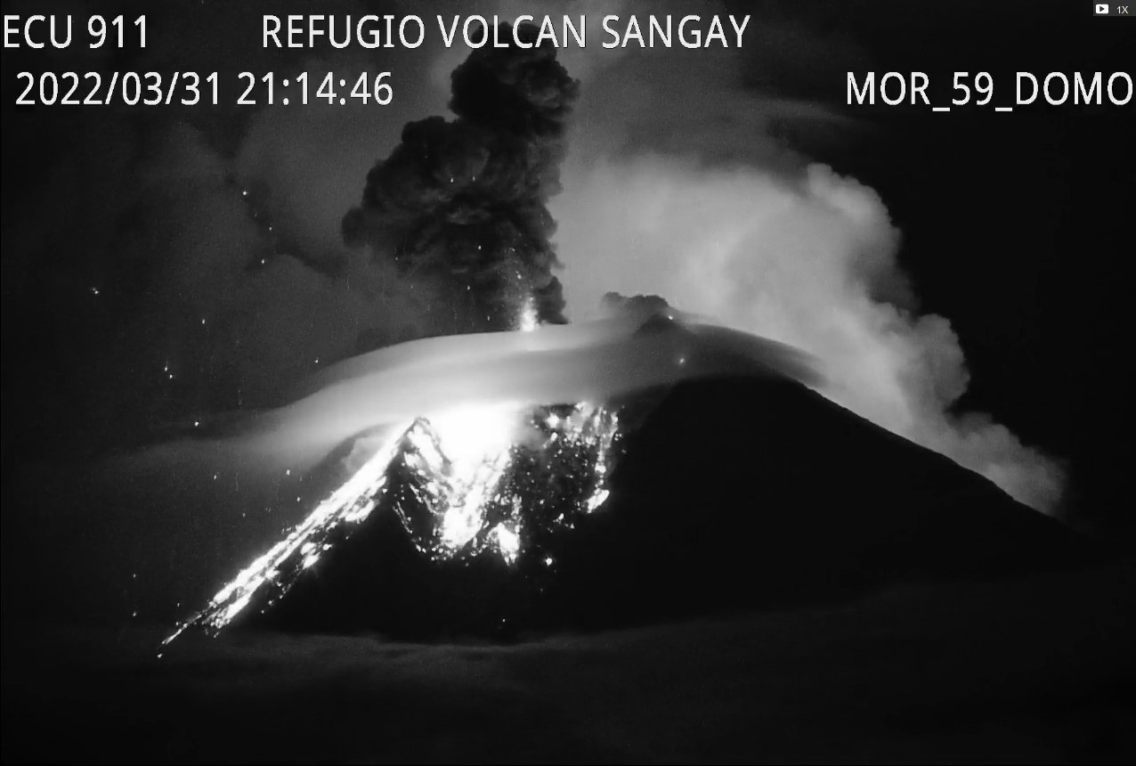
Ecuador , Sangay :
DAILY REPORT OF THE STATE OF SANGAY VOLCANO, Friday April 01, 2022.
Information Geophysical Institute – EPN.
Surface Activity Level: High, Surface Trend: No change.
Internal activity level: High, Internal trend: No change.
Seismicity: From March 31, 2022, 11:00 a.m. to April 01, 2022, 11:00 a.m.:
Explosion (EXP) 62
Long Periods (LP) 32
Emission Tremors (TREMI) 44
Rains / Lahars:
No rain was recorded in the area. **In the event of heavy rains, these could remobilize the accumulated materials, generating mudslides and debris that would descend on the flanks of the volcano and flow into the adjacent rivers.**
Emission / ash column:
Today morning, between the clouds, an emission of ash from a height of more than 800 meters was observed in a westerly direction. The Washington VAAC recorded 5 gas and ash emission alerts with heights of 870 meters up to 1,170 meters above crater level, heading west and southwest.
Gas:
The MOUNTS system records 2169 tonnes of SO2 on 03/31/22 at 7:05 p.m. UT.
Other Monitoring Parameters:
The FIRMS system records 17 thermal anomalies over the past 24 hours.
Observation:
Last night, through images shared by ECU911, several explosions with rolling blocks were observed on the flanks of the volcano.
Alert level: Orange.
Source : IGEPN.
Photo : Webcam


No comment yet, add your voice below!