
March 30 , 2022 .
Italy , Stromboli :
WEEKLY BULLETIN, from March 21, 2022 to March 27, 2022. (issue date March 29, 2022)
ACTIVITY STATUS SUMMARY
In the light of the surveillance data, it is highlighted:
1) VOLCANOLOGICAL OBSERVATIONS: During this period, normal explosive activity of the Strombolian type was observed with projection activity in the N zone. The total hourly frequency of explosions fluctuated between average values (12 events/h) and average values – high (17 events/h) with the sole exception of March 26 with high values (24 events/h). The intensity of the explosions was mainly medium and low in the area of the North crater and low in the area of the Center-South crater.
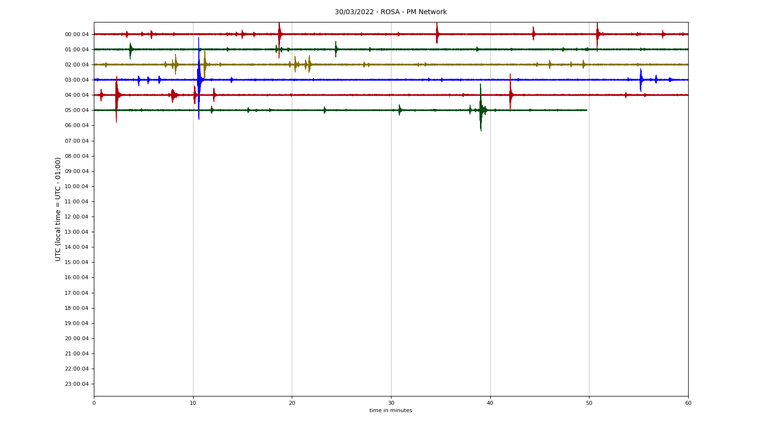
2) SEISMOLOGY: The seismological parameters monitored do not show any significant variations.
3) SOIL DEFORMATIONS: The island’s soil deformation monitoring networks did not show any significant variation.
4) GEOCHEMISTRY: SO2 flux at an average level
CO2 fluxes in the crater area remain at high values.
Due to technical issues, there are no updates on the C/S ratio in the plume.
There are no updates on the isotope ratio of helium in groundwater.
5) SATELLITE OBSERVATIONS: The thermal activity observed by satellite was at a low level.
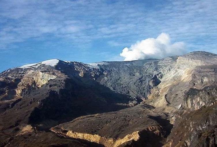
VOLCANOLOGICAL OBSERVATIONS
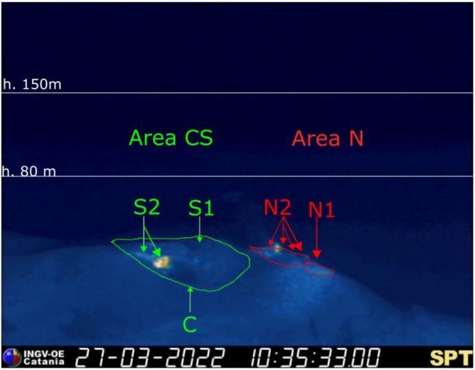
During the observation period, the eruptive activity of Stromboli was characterized through the analysis of images recorded by the INGV-OE surveillance cameras (altitude 190m, Punta Corvi, altitude 400m and Pizzo). The explosive activity was mainly produced by 5 (five) eruptive vents located in the North crater area and 2 (two) eruptive vents located in the Center-South crater area. All the mouths are located inside the depression which occupies the terrace of the crater.
Sector N1 located in the area of the North crater produced explosions of variable intensity from low (less than 80 m high) to medium (less than 150 m high) emitting coarse materials (lapilli and bombs). Sector N2, with four emission points, showed explosive activity of medium-low intensity (less than 120 m in height) emitting coarse materials with intense projection activity during short intervals between the 25th and the 27th. March . The average frequency of explosions varied from 8 to 18 events/h.
In the Center-South zone, sectors C and S1 did not show significant explosive activity. Sector S2, with two emission points, had low intensity explosions (the products of the explosions did not exceed 80 m in height) emitting coarse materials. The frequency of the explosions varied between 4 and 7 events/h.
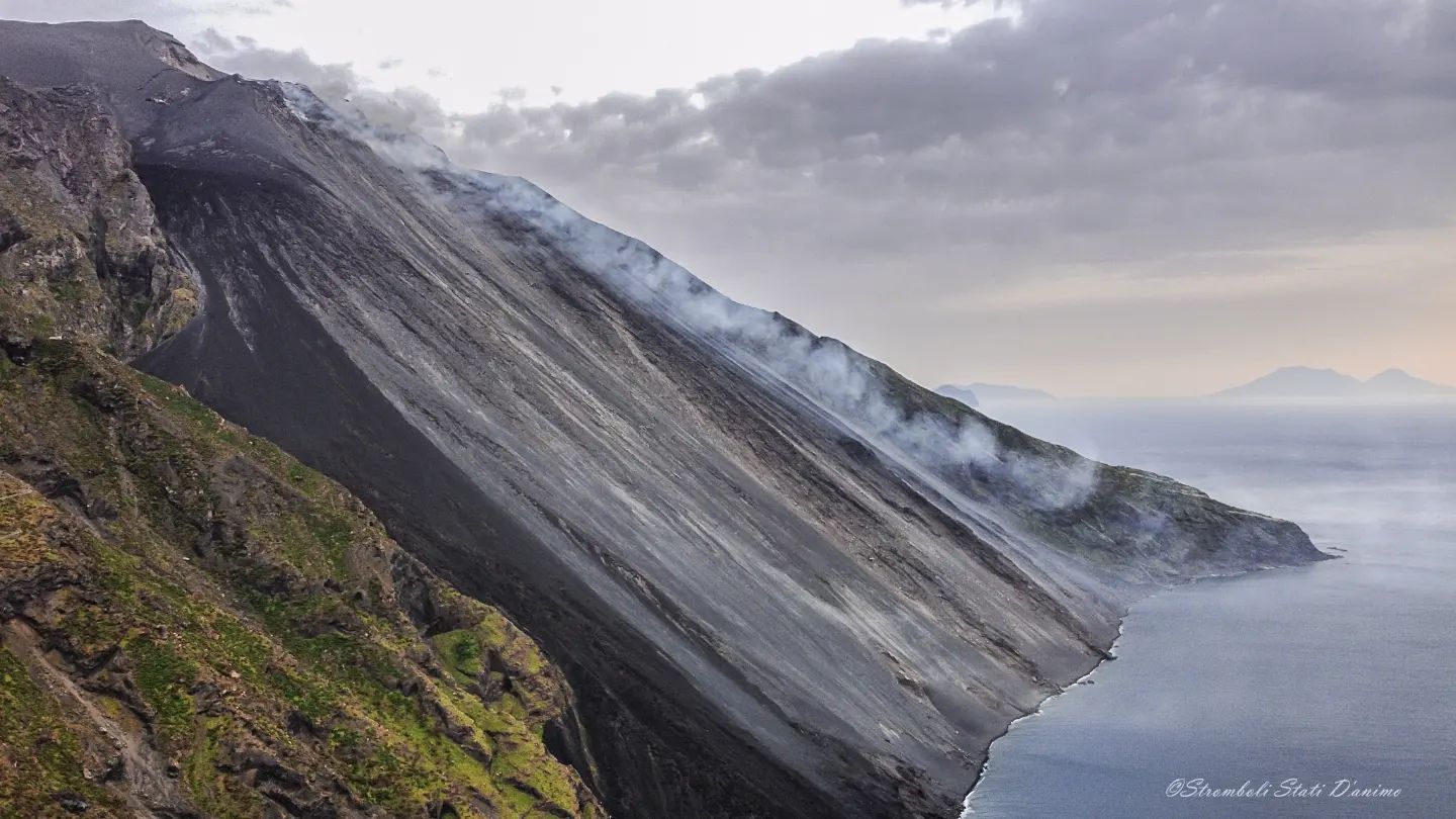
Source : INGV.
Photo : Stromboli stati d’animo.
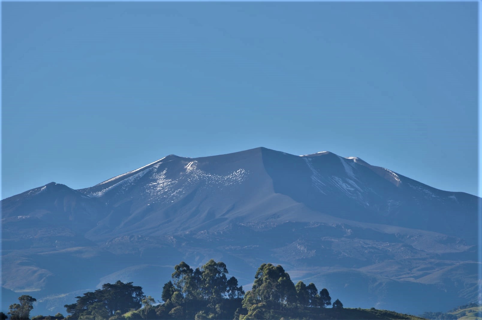
Italy , Vulcano :
WEEKLY BULLETIN, from March 21, 2022 to March 27, 2022. (issue date March 29, 2022)
ACTIVITY STATUS SUMMARY
In the light of the surveillance data, it is highlighted:
1) Temperature of the crater fumaroles: The updated data of the temperatures recorded on the edge of the crater show stable values.
2) CO2 flux in the crater area: The CO2 flux in the crater area remains at high values.
3) SO2 flux in the crater area: SO2 flux at a medium-high level
4) Geochemistry of fumarolic gases: no update is available.
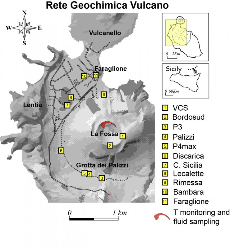
5) CO2 fluxes at the base of the La Fossa cone and in the Vulcano Porto area: The CO2 fluxes recorded in the Rimessa, C. Sicilia and P4max sites show a slight downward trend, but remain on medium-high values; in the Faraglione site, there are values close to the background level.
6) Geochemistry of thermal aquifers: The temperature measured in the Camping Sicilia well is at high and stable values. The electrical conductivity shows oscillations around low values. The Bambara well shows slightly decreasing values of the two monitored parameters.
7) Local seismicity: Low seismic activity, both in terms of high-frequency micro-tremors and the presence of VLP-type events.
8) Regional seismicity: no regional seismic event is noted
9) Deformations – GNSS: The network of permanent GNSS stations has not recorded any significant changes.
10) Deformations – Inclinometry: The inclinometric network has not recorded any significant changes
11) Other observations: FTIR data shows a decrease in the relative presence of CO2 and SO2 compared to the values observed in November 2021.
Gravimetry: During the period considered, no significant change was recorded.
GB-RAR: The GB-RAR monitoring results referring to the period from December 14, 2021 to March 28, 2022, show a general stability of the area, with deformations along the LOS of less than 1 mm.
Mobile GNSS: No significant changes are visible during the reporting period.
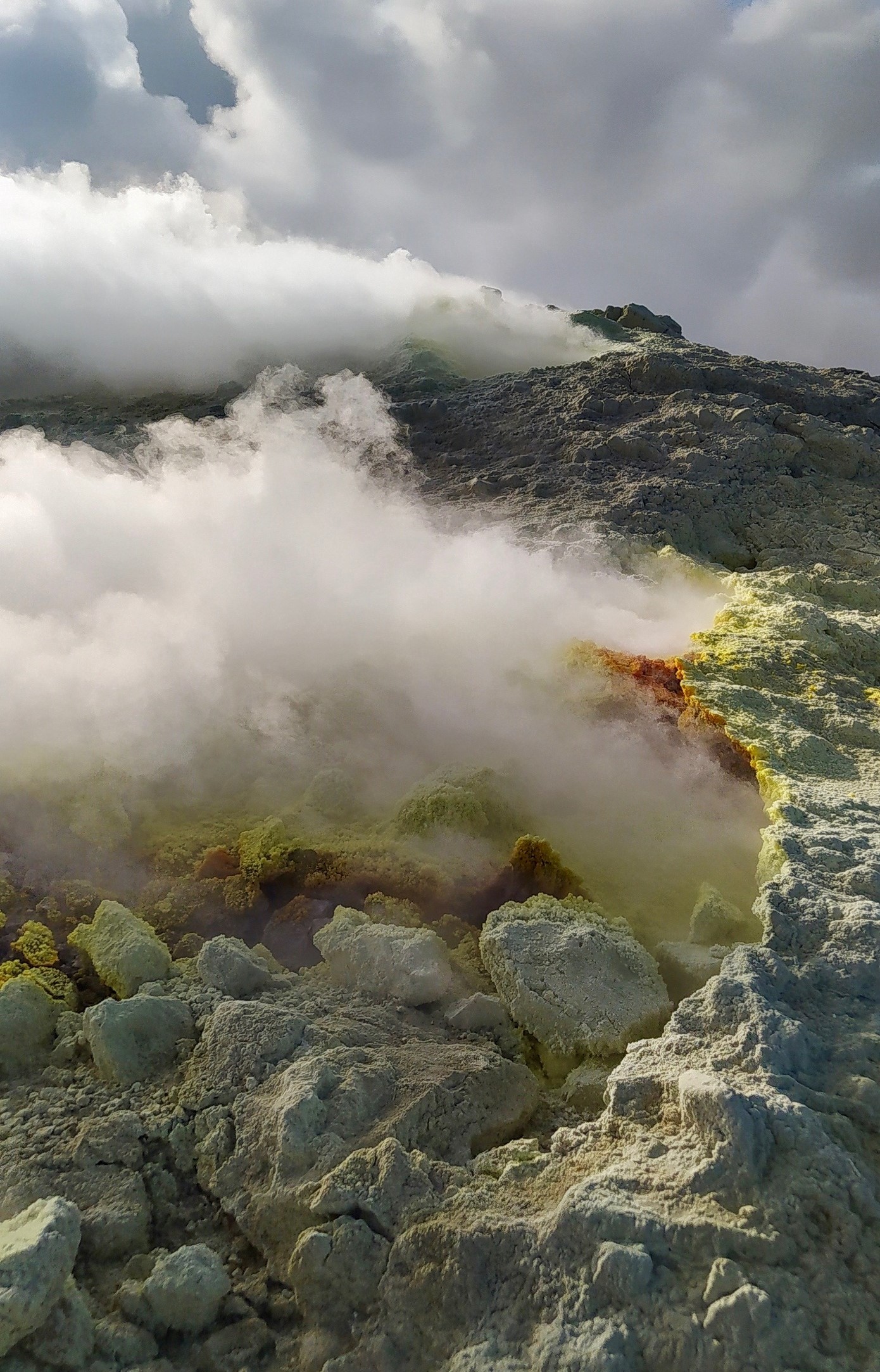
CRATER SMOKE TEMPERATURE:
The reference sensor for the maximum temperature has very stable values, with a weekly average of 384°C. The sensor placed in the fumarole on the inner side did not exceed 104°C, but the data is not stable and seems to indicate that this measurement line requires maintenance.
CO2 FLOW IN THE CRATER AREA
The ground CO2 flux values in the summit zone in daily average (VCSCS) show high values around 13634 g/m2/day on March 25, 2022, still more than an order of magnitude higher than the averages recorded during the last 10 years.
Source : INGV.
Photo : G. De Astis (INGV-Rome1)
Colombia , Nevado del Ruiz :
Bulletin of activity level of the Nevado del Ruiz volcano.
The activity level continues at the yellow activity level or (III): changes in the behavior of volcanic activity.
Regarding the monitoring of the activity of the Nevado del Ruiz volcano, the COLOMBIAN GEOLOGICAL SERVICE reports that:
Seismicity associated with rock fracturing increased in number of earthquakes and seismic energy released, compared to the previous week. This seismic activity was located mainly in the North-North-West sectors, in the Arenas crater and to the North-East of the volcano, as well as to a lesser extent in the South-East, West-South-West and North-West sectors. The depth of the earthquakes varied between 0.9 and 7.8 km.
An increase in this activity stands out on March 27, located at an average distance of 1.9 km north-northwest of the Arenas crater. The maximum magnitude recorded during the increase, which in turn is the largest of the week, was 3.4 ML (Local Magnitude), corresponding to the earthquake that occurred on March 27 at 5:24 p.m. (local time), located 1.9 km north-northwest of the Arenas crater, at a depth of 3.8 km.
Seismicity related to fluid dynamics within volcanic conduits decreased in the number of earthquakes and remained similar in seismic energy released, compared to the previous week. This seismic activity was characterized by the appearance of continuous volcanic tremors, sliding type tremors, tremor pulses, some with « swarm » type characteristics, long and very long period type earthquakes. In general, these signals exhibited low to moderate energy levels, variable spectral content, and were located primarily within Arenas Crater. Thanks to the cameras installed in the area of the volcano and the report of the officials of the National Natural Park of Los Nevados, the gas and ash emissions associated with some of these signals have been confirmed.
Likewise, thanks to the FLIR cameras of the volcanic monitoring network, changes in the relative temperature of the emitted materials have been observed.
Source : SGC
Photo : alertatolima.com
Colombia , Puracé :
Subject: Activity of the Volcan Puracé. The Green Level of activity is maintained or (IV): Active volcano and stable behavior.
Regarding the monitoring of the activity of the Volcan Puracé, the COLOMBIAN GEOLOGICAL SERVICE reports that:
For the past few weeks, there has been a significant change in the activity of the Puracé volcano which is characterized by the increase in the number of earthquakes associated with the fracture of the rock in the volcanic edifice (type VT), accompanied by fluid movement events within it (LP and TR type).
As of 8:00 p.m. on March 28, 2022, the occurrence of 479 VT type events, 183 LP events and 119 TR events can be distinguished. After 10:00 a.m. on March 29, there was a sudden increase in the scale and recurrence of this activity, which continues at the time of this bulletin’s publication. From this seismicity, the 12:14 earthquake. located near the volcano with a magnitude of ML 3.3 stands out.
It is recommended that the community continue to be alert to any changes in the activity of the volcano.
Source et photo : SGC.
Azores , São Jorge :
The seismic swarm on the island of São Jorge, in the Azores, seems to be losing strength in recent days, given the seismograms and the number of localized earthquakes, neither an increase in magnitude nor a progression in depth towards the surface are recorded. All this can change, both in an increase in activity or this could continue to stop until normal values.
Possible scenarios for São Jorge volcano:
It is impossible to predict what will happen, whether an eruption will take place in the near future. All of the following scenarios are possible, but we do not know how likely each of them might be:
1) An eruption takes place within days or weeks from now, with little warning.
2) The seismic swarm and ground deformation end gradually or abruptly, only to be repeated in months or years from now. Eventually one of these will be leading up to an eruption then.
3) A stronger earthquake occurs and changes the configuration of the magma intrusion, either to stall or to break through to the surface in an eruption.
4) Activity dies down, and the magma intrusion at depth slowly cools over years and decades to come with no further activity directly related to it.
.
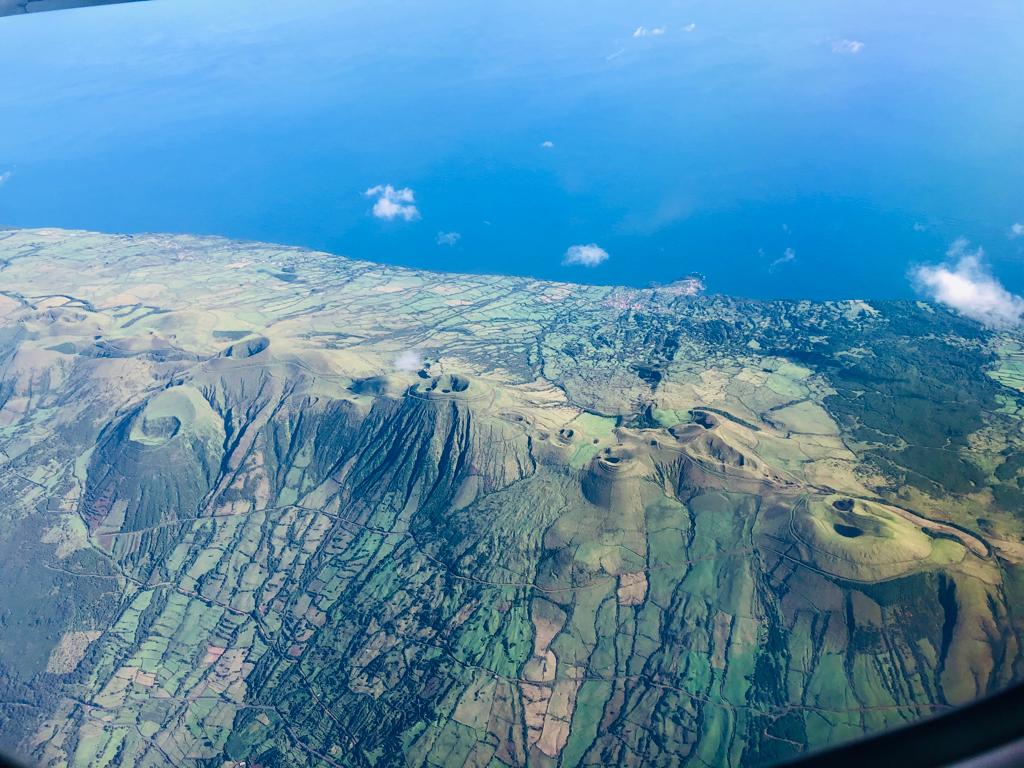
The dominantly basaltic São Jorge Island is 55 km long and 6.5 km wide. It was formed by fissure eruptions beginning in the eastern part of the island. The western two-thirds of the island contains youthful, fissure-fed lava flows resembling those on neighboring Pico Island. Lava effused from three locations above the south-central coast during 1580, producing flows that reached the ocean. In 1808 a series of explosions took place from vents along the south-central crest of the island; one of the vents produced a lava flow that reached the southern coast. Submarine eruptions have also been reported on several occasions from a submarine ridge to the SE. The 1964 event offshore W of Velas was considered « probable » by Madiera and Brum da Silveira (2003), who also provided 14C dates for several other Holocene eruptions.
Sources : GEVolcans , Volcanodiscovery , GVP.
Photo : Eva K / Volcanodiscovery.
Hawaii , Kilauea :
19°25’16 » N 155°17’13 » W,
Summit Elevation 4091 ft (1247 m)
Current Volcano Alert Level: WATCH
Current Aviation Color Code: ORANGE
Activity Summary:
The summit eruption of Kīlauea Volcano, within Halemaʻumaʻu crater, continued over the past 24 hours. All recent activity has been confined to the crater, and there are no indications of activity migrating elsewhere on Kīlauea.
Halemaʻumaʻu Lava Lake Observations:
Eruption of lava from the western vent into the active lava lake (approximately 2.5% of the crater floor surface) and onto the crater floor continued over the past 24 hours. There were also numerous and sustained oozeouts along the margins and interior seams of the crater floor. Since the beginning of this eruption on September 29, 2021, the crater floor has seen a total rise of about 93 meters (305 feet). The volume of lava effused since the beginning of this eruption was approximately 58 million cubic meters (76 million cubic yards) as measured on March 17, 2022.
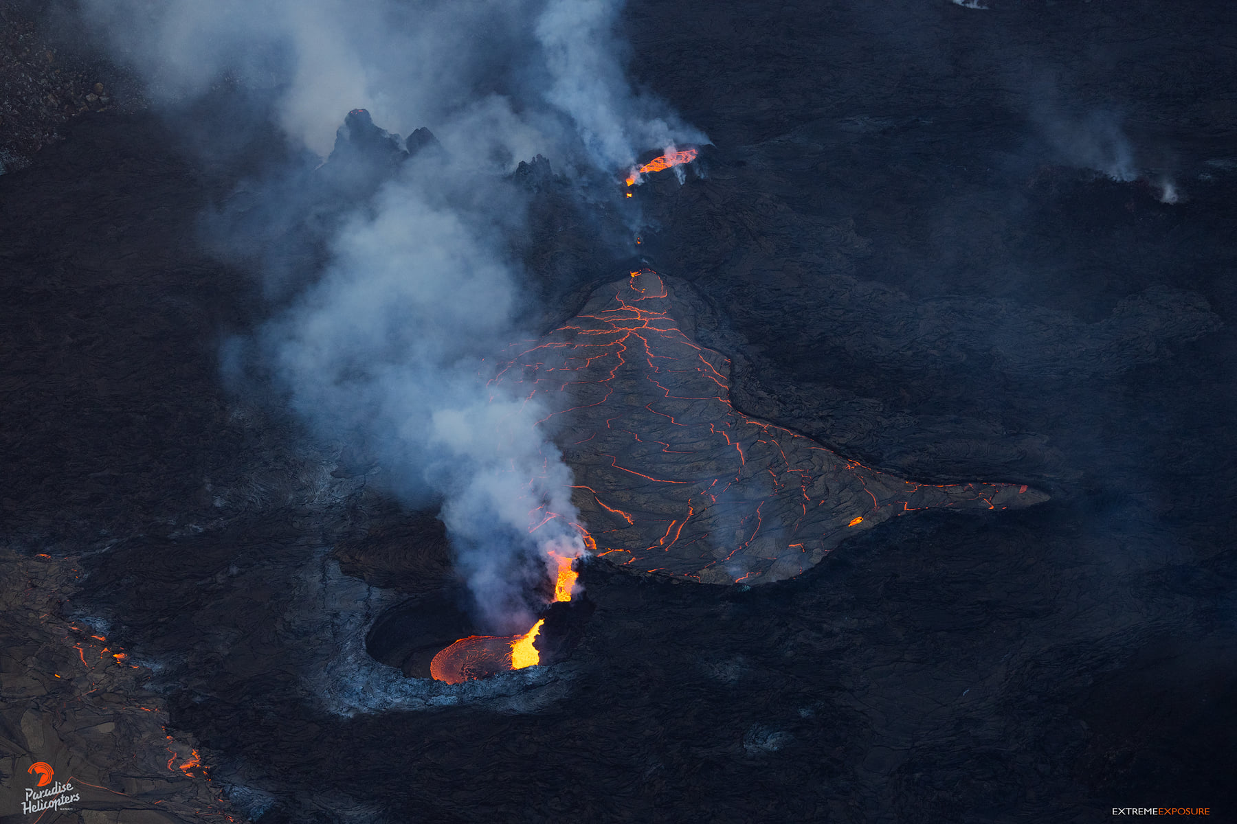
Summit Observations:
Summit tilt has been mostly stable, with an overall minor deflationary trend over the past 24 hours. Volcanic tremor remains above background levels. A sulfur dioxide (SO2) emission rate of approximately 1,400 tonnes per day (t/d) was measured on March 23, 2022.
Source : HVO.
Photo : Bruce Omori / Paradise Helicopters.


No comment yet, add your voice below!