March 22 , 2022.
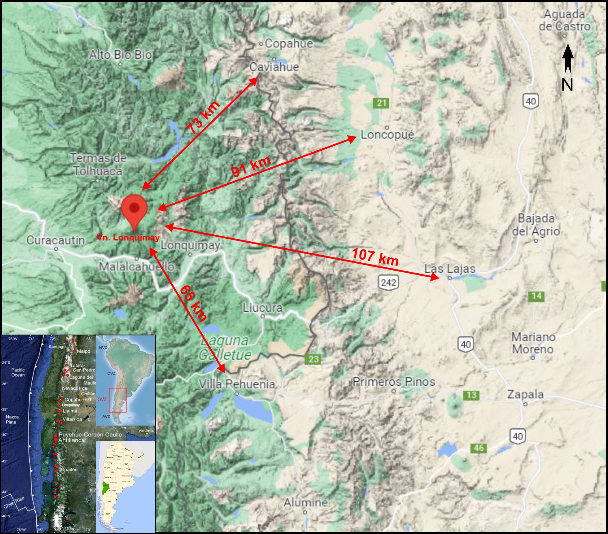
Chile , Lonquimay :
The Geological Service of Argentine Mines (SEGEMAR) through its Argentine Volcanic Monitoring Observatory (OAVV) informs based on information from the Volcanological Observatory of the Southern Andes (OVDAS) of Chile, that this Monday, March 21, 2022 , the technical alert level of the Lonquimay volcano is raised to the Yellow level.
The Lonquimay volcano is a stratovolcano located in the Araucania region, entirely on Chilean territory. The nearest towns located on Argentine territory are in the province of Neuquén within a radius of between 70 and 100 km from the volcano, these are the towns of Loncopué, Villa Pehuenia, Caviahue, Copahue, Las Lajas and Primeros Pinos , as well as the international col pino Hachado.
![]()
This change in technical alert level is based on an increase in the volcano’s seismicity parameters throughout the month of March, especially since the 9th. In this context, the Lonquimay volcanic complex has developed a sequence of earthquakes, associated to the movement of fluids in the volcano, mainly of the hybrid type (HB) and to a lesser extent of the long period type (LP). In addition, seismic activity associated with rock fracturing, volcano-tectonic (VT) type, was also observed.
On the other hand, no changes were detected with respect to information from surface deformation data, surface manifestations of volcanic gases (sulphur dioxide, SO₂), thermal anomalies or any other type of activity. of surface.
All the seismicity recorded so far has a low magnitude, being only possible to locate some of the HB and VT earthquakes near the main volcanic building, with distances between 2 and 7 km, and depths that vary between 4 and 11 km in reference to the summit of the volcano. However, these changes are rare in the historical archives of permanent monitoring of the volcano which began in 2010 (the year of the installation of monitoring stations on Chilean territory).
REMARKS:
It is emphasized that with the current scenario, no imminent eruption is expected in the short term, nor any impact on Argentine territory.
CONCLUSION
Although since the beginning of the instrumental monitoring carried out by the OVDAS, the seismicity of this volcano has remained at relatively low values, the recording of this abnormal seismicity initiated throughout this last month suggests that the volcano is au- above its base level and could indicate that we are facing the presence of precursor signals that could evolve towards an eruptive process.
For this reason and as a preventive measure, the technical alert level is changed to YELLOW and the monitoring of the volcano will continue in constant communication with the Volcanological Observatory of the Andes of the South (OVDAS) of Chile, reporting any changes that have occurred.
Source : Segemar.
Photo : Sernageomin.
Alaska , Semisopochnoi :
51°55’44 » N 179°35’52 » E,
Summit Elevation 2625 ft (800 m)
Current Volcano Alert Level: WATCH
Current Aviation Color Code: ORANGE
Seismic tremor and occasional small explosions were detected in seismic and local infrasound data over the past day. Clear webcam images showed low-level ash emissions from the north crater of Mount Cerberus.
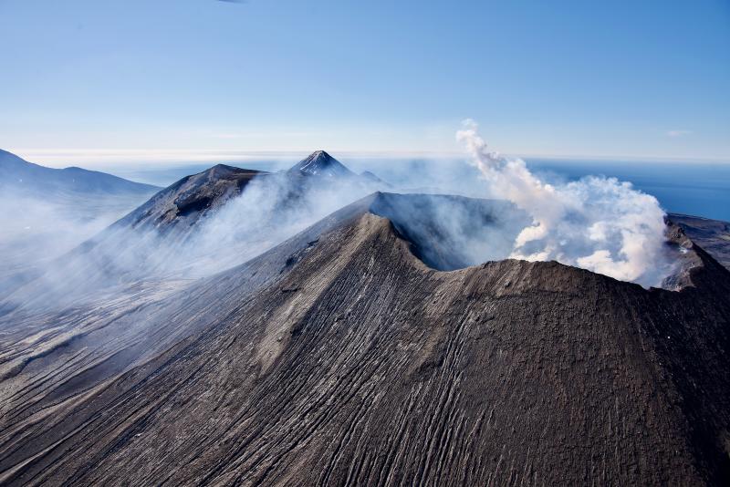
Small eruptions producing minor ash deposits within the vicinity of the active north crater of Mount Cerberus and ash clouds usually under 10,000 ft (3 km) above sea level have characterized the recent activity. Small explosions and associated ash emissions may continue and could be difficult to detect, especially when thick cloud cover obscures the volcano.
Semisopochnoi is monitored by local seismic and infrasound sensors, satellite data, web cameras, and remote infrasound and lightning networks.
Source : AVO.
Photo : Read, Cyrus / Alaska Volcano Observatory / U.S. Geological Survey.
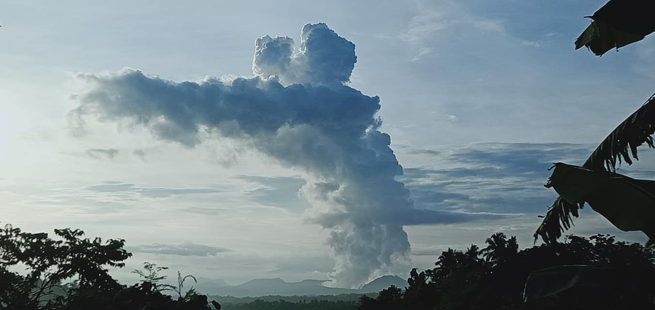
Philippines , Taal :
TAAL VOLCANO BULLETIN 22 March 2022 8:00 AM
In the past 24-hour period, the Taal Volcano Network recorded forty-seven (47) volcanic earthquakes, including twenty-five (25) volcanic tremor events having durations of one (1) to six (6) minutes, and twenty-two (22) low-frequency volcanic earthquakes. Activity at the Main Crater was dominated by upwelling of hot volcanic fluids in its lake which generated plumes 2,400 meters tall that drifted southwest. Sulfur dioxide (SO2) emission averaged 6,377 tonnes/day on 21 March 2022. Temperature highs of 63.7°C were last measured from the Main Crater Lake on 25 February 2022. Based on ground deformation parameters from electronic tilt, continuous GPS, and InSAR monitoring, Taal Volcano Island and the Taal region has begun deflating in October 2021.
Alert Level 2 (Increased Unrest) prevails over Taal Volcano. DOST-PHIVOLCS reminds the public that at Alert Level 2, sudden steam- or gas-driven explosions, volcanic earthquakes, minor ashfall, and lethal accumulations or expulsions of volcanic gas can occur and threaten areas within and around TVI. DOST-PHIVOLCS strongly recommends that entry into Taal Volcano Island, Taal’s Permanent Danger Zone or PDZ must be strictly prohibited, especially the vicinities of the Main Crater and the Daang Kastila fissure, and extended stays on Taal Lake.
Source : Phivolcs.
Photo : JhuLia Mendoza.
Indonesia , Ibu :
VOLCANO OBSERVATORY NOTICE FOR AVIATION – VONA
Issued : March 22 , 2022
Volcano : Ibu (268030)
Current Aviation Colour Code : ORANGE
Previous Aviation Colour Code : orange
Source : Ibu Volcano Observatory
Notice Number : 2022IBU14
Volcano Location : N 01 deg 29 min 17 sec E 127 deg 37 min 48 sec
Area : North Maluku, Indonesia
Summit Elevation : 4240 FT (1325 M)
Volcanic Activity Summary :
Eruption with volcanic ash cloud at 01h00 UTC (10h00 local).
Volcanic Cloud Height :
Best estimate of ash-cloud top is around 6800 FT (2125 M) above sea level, may be higher than what can be observed clearly. Source of height data: ground observer.
Other Volcanic Cloud Information :
Ash-cloud moving to southeast.
Remarks :
Eruption and ash emission is continuing.
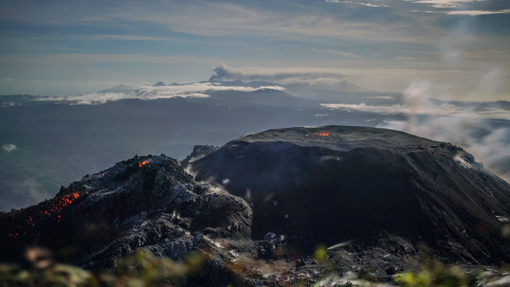
The volcano was clearly visible until it was covered in fog. Smoke from the crater is white / gray with low to moderate intensity, about 200-800 meters above the summit. The weather is sunny to rainy, the wind is weak to moderate in the North-East and in the West.
The eruption was observed at a height of 200 to 800 meters above the summit, the eruption ash column was white / gray.
Avalanches occur, but visually the sliding distance and direction of the avalanches are not observed.
Earthquakes are related to magma and tectonic activity. It was recorded:
– 78 earthquakes of eruptions/explosions
– 58 avalanche earthquakes
– 21 emission earthquakes
– 12 harmonic tremors
– 28 shallow volcanic earthquakes
Sources : Magma Indonésie , PVMBG.
Photo : Martin Rietze .
Portugal / Azores Islands , San Jorge :
Azores Islands. A seismic swarm is recorded on the archipelago, in particular on the island of Saint-Georges, an insular zone and autonomous region of Portugal.
The 53 km long and 8 km wide island has just over 10,000 inhabitants and since the evening of March 19, a sequence of seismic events of small magnitudes has begun, located in the center-northwest of the island. Since then, more than 700 events have been recorded, 19 of which have magnitudes in the order of M2.0 to M3.6 according to the Azores Seismo-Volcanic Monitoring Center (CIVISA).
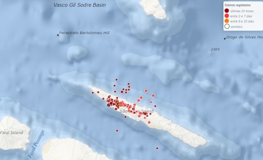
The most important events were perceptible by the population, in particular an M 3.6 which was largely felt by the population with intensities up to V on the Mercalli scale, without recording any damage. After a little more than 24 hours, the events continue but in smaller size, perhaps imperceptible.
For the moment there is no clear data on the origin of these events, in particular if it is of volcanic origin by magmatic intrusion or simply by tectonic nature as was the case for the last time. in 2018 with a swarm of 300 events.
After the activity, there is no evidence of deformation or other data indicating volcanic activity, but the seismic danger is very high and the impact on the island would be regrettable due to the shallow origin and the proximity of the population to the focus of the events.
As a result of the earthquakes, the Civil Protection has communicated with local mayors and fire units, asking them to « stay alert » and help the inhabitants of Saint-Georges if necessary, the authority called to remain calm , to be informed and follow the recommendations of officials.
The last major earthquake to hit the region occurred in 1980 with an estimated magnitude of M 7.0, left 71 dead, 400 injured and destroyed over 15,000 homes, involving different islands.
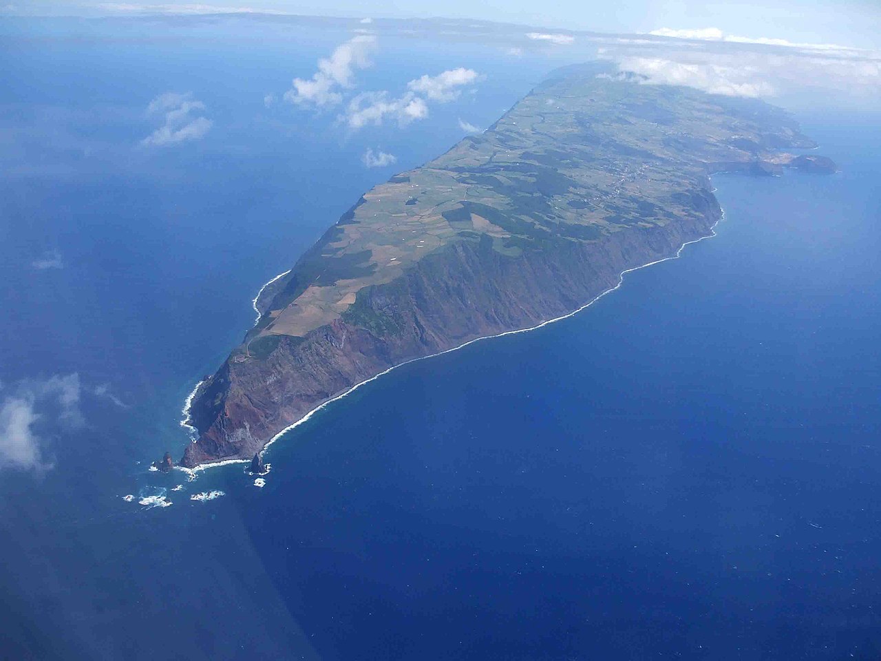
The island of volcanic origin had its last eruption in 1808, the historical activity is mainly related to the structures of fissure eruptions, which explains its elongated and narrow physiognomy.
The linear São Jorge Island is 54 km long and only 6 km wide. It was formed by fissure eruptions beginning in the eastern part of the island. The western two-thirds of dominantly basaltic São Jorge contains youthful, fissure-fed lava flows resembling those on neighboring Pico Island. Lava effused from three locations above the south-central coast during 1580, producing flows that reached the ocean. In 1808 a series of explosions took place from vents along the south-central crest of the island; one of the vents produced a lava flow that reached the southern coast. Submarine eruptions were reported on several occasions from vents off the S and SW coasts.
Sources : EarthQuakesTime via Volcanes y Ciencia Hoy , GVP.
Photos : EarthQuakesTime , José Luís Ávila Silveira/Pedro Noronha e Costa (wikipedia) ,


No comment yet, add your voice below!