
March 09 , 2022.
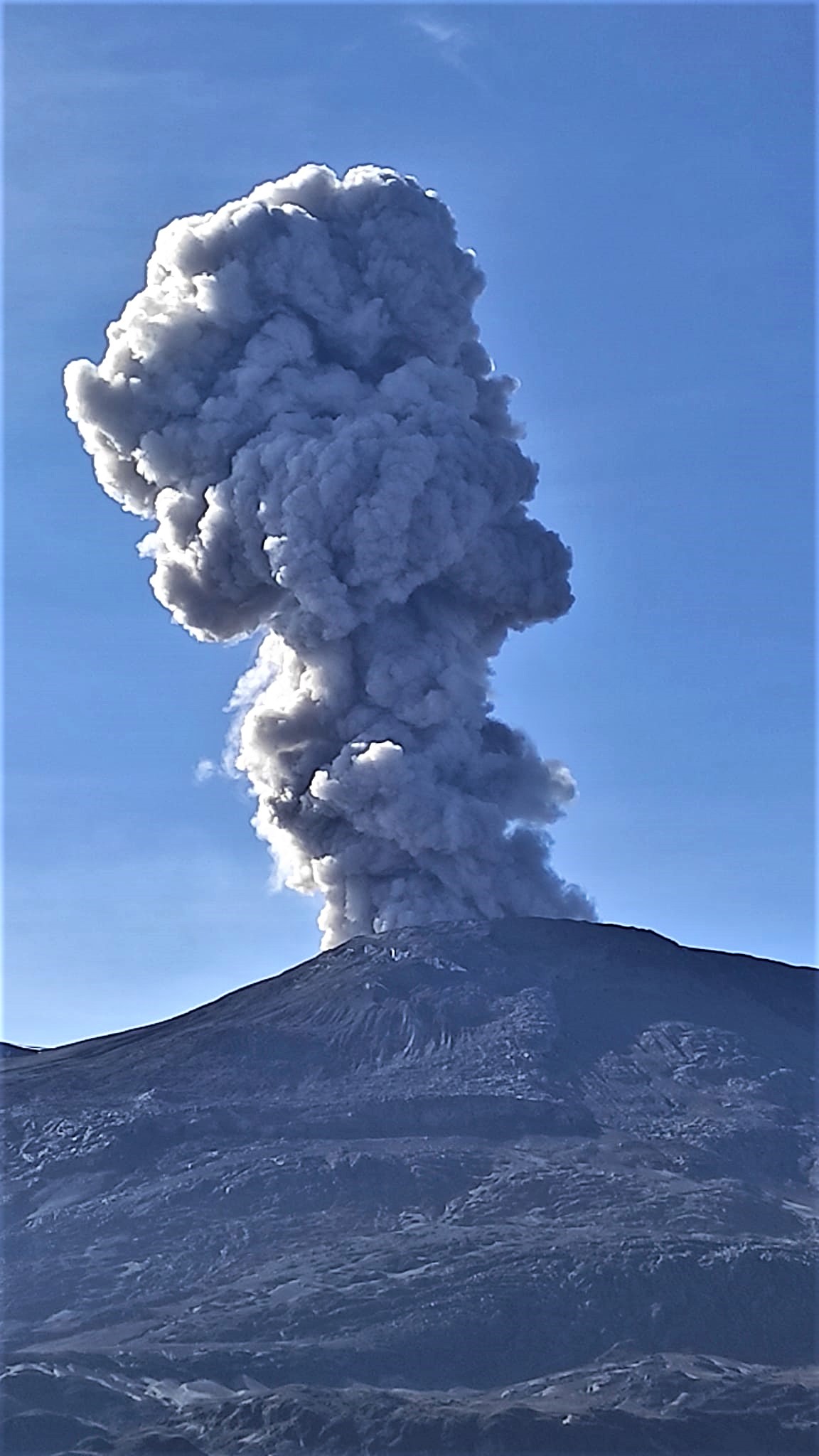
Italy / Sicily , Etna :
WEEKLY BULLETIN, from February 28, 2022 to March 06, 2022. (issue date March 08, 2022)
ACTIVITY STATUS SUMMARY.
In the light of the surveillance data, it is highlighted:
1) VOLCANOLOGICAL OBSERVATIONS: Degassing activity of the summit craters; degassing and sporadic ash emissions from the Northeast Crater; modest collapses of material from the inner walls of the Southeast Crater.
2) SEISMOLOGY: Low seismic activity of fracturing. Average amplitude of the tremor in the low level, excluding a brief and moderate increase on March 2.
3) INFRASONO: Low infrasonic activity.

4) GROUND DEFORMATIONS: Over the past week, ground deformation monitoring networks have not recorded any significant changes.
5) GEOCHEMISTRY: SO2 flux at a medium-low level and moderately increasing.
The soil CO2 flux shows average values with a slightly decreasing trend.
The partial pressure of dissolved CO2 in groundwater shows values in seasonal variability.
No update is available regarding the isotopic ratio of Helium (peripheral gases). The latest data from February 15, 20222 indicated high values of the isotope ratio (0.66).
6) SATELLITE OBSERVATIONS: Thermal activity in the summit area was at a low level after the February 21, 2022 lava fountain.
VOLCANOLOGICAL OBSERVATIONS
During the week, the monitoring of the volcanic activity of Etna was carried out by analyzing the images of the network of surveillance cameras of the INGV, Etneo Observatory (INGV-OE).
The presence of cloud cover for most of the week made observations inconsistent.
During the observation period, activity consisted of the usual variable outgassing activity at summit craters, particularly at Bocca Nuova (BN) crater, where outgassing was continuous and often pulsating.
In general, in the period studied, the activity of Etna was characterized by variable degassing at the level of the summit craters, by degassing with sporadic emission of ash at the level of the Northeast Crater (NEC) and by collapses occasional unstable materials from the inner walls of the Southeast Crater (SEC).

In particular, after the paroxysm of February 21, the Southeast Crater (SEC) showed fumarolic degassing concentrated especially in the apical part of the cone. On March 3, at 18:15.45 UTC, a thermal anomaly was observed on the southern inner wall of the crater, associated with the formation of a dust cloud which quickly dispersed in the atmosphere; this anomaly, evident for several days, was probably caused by the collapse of slag from the inner walls of the crater, which exposed still hot material accumulated during the eruptive activity of February 21.
Source : INGV.
Photos : Gio Giusa , Francesco Ciancitto.
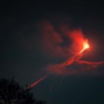
Guatemala , Fuego :
Guatemala’s relief and civil protection agencies began a « preventive » evacuation of a community on the slopes of the Fuego volcano on Monday; with a strong activity since last weekend.
The National Coordinator for Disaster Prevention (Conred) explained to reporters that the evacuation is taking place in the town of Panimaché 1; in the municipality of San Pedro Yepocapa in the department of Chimaltenango; about 60 kilometers west of Guatemala City. According to the state entity, around 150 people are transferred to shelters in the department of Escuintla, located in the south of the country and also adjacent to the volcano.
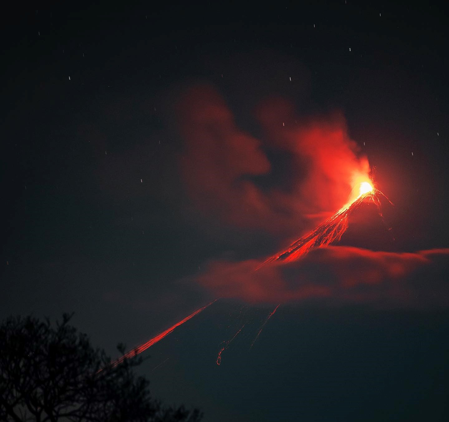
The Fuego volcano recorded in the early hours of Monday a Strombolian eruption that caused lava avalanches, between moderate and strong.
The National Institute of Seismology, Volcanology, Meteorology and Hydrology (Insivumeh) warns in its latest bulletin that the activity of the volcano remains high and that it could increase “suddenly” in the coming hours.
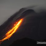
End of the paroxysm.
Following the eruption of the Fuego volcano and BEFGO bulletin # 011-2022, it is reported that the seismic and acoustic monitoring parameters, field observations made by volcanology personnel in the region and the Fuego Volcano Observatory ( OVFGO), indicate that in the last few hours this activity is gradually decreasing, but still with ashes in the environment and a smell of sulfur. This results in low effusive activity, allowing magmatic material extrusion to decrease drastically. Likewise, the sounds of emissions have decreased. The RSAM graph (Figure 1) reflects the decrease in its seismic amplitude around 3 a.m. and its tendency to remain close to its base line of activity. These changes suggest the end of the paroxysmal activity of the Fuego volcano, which had a total duration of 26 hours.

Seismic and acoustic sensors confirm that the activity that persists in the crater are explosions and weak rumblings that are still generating some avalanches, mainly towards the Ceniza and Seca ravines. Due to the above, it is not excluded that new lava flows will be generated towards other ravines, as well as violent ash-laden explosions and avalanches of weak to moderate characteristics towards one of the ravines of the Fuego volcano, which is why one should not stay near or in the canyons of the volcano.
VOLCANIC ACTIVITY UPDATE
In the follow-up of the BEFGO bulletin # 012-2022 and on the basis of instrumental parameters and field monitoring, explosions of weak and moderate characteristics with abundant ash emissions are recorded, which move towards the West and the South- West for more than 40 km. The crater continues to generate a characteristic slight degassing and degassing sounds. Due to recent eruptive activity, unstable materials have accumulated around the volcanic edifice, causing these materials to collapse in explosions, and then descend as weak to moderate avalanches into the ravines recently affected. Field monitoring by staff from the OVFGO Fuego Volcano Observatory confirmed a large number of ash deposits on vegetation, house roofs and community streets. These ashes can be carried by the wind and remain suspended at low levels in the air, creating a foggy environment for several hours which can be detrimental to the health of people.
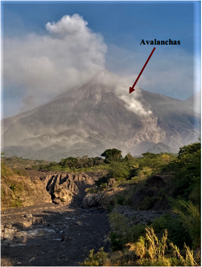
Fig1: presence of avalanches in Las Barranca Las Lajas. Photo by Daniel Aguirre, San Miguel Duenas.
Seismic and acoustic sensors confirm that the activity that persists in the crater are explosions and weak rumblings that still generate avalanches mainly towards the Ceniza and Seca ravines, Trinidad and Las Lajas. It is not excluded that new lava flows will be generated towards other ravines, as well as violent ash-laden explosions and avalanches of moderate characteristics towards one of the ravines of the Fuego volcano, which is why we should not not stay near or in the ravines of the volcano. INSIVUMEH maintains visual and instrumental monitoring of volcanic activity through seismic stations, volcano spotters and web cameras.
Sources : tn8.tv, Insivumeh .
Photo : Diego Rizzo Photo. Daniel Aguirre, San Miguel Dueñas.
Italy , Stromboli :
WEEKLY BULLETIN, from February 28, 2022 to March 06, 2022. (issue date March 08, 2022)
ACTIVITY STATUS SUMMARY.
In the light of the surveillance data, it is highlighted:
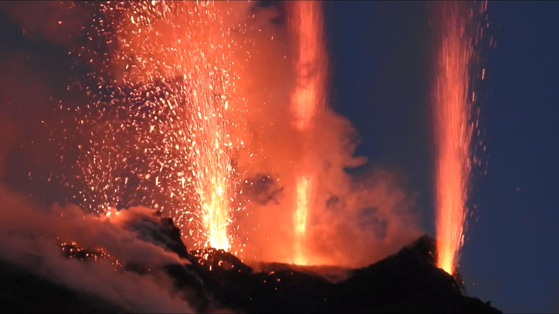
1) VOLCANOLOGICAL OBSERVATIONS: During this period normal explosive activity of the Strombolian type was observed with projection activity in the N zone. The total hourly frequency of the explosions varied between low values (5 events/h) and medium values- high (17 events/h). The intensity of the explosions was mainly medium to low in the area of the North crater and low in the area of the Center-South crater.
2) SEISMOLOGY: The seismological parameters monitored do not show any significant variations.
3) SOIL DEFORMATIONS: The island’s soil deformation monitoring networks did not show any significant changes to report for the period under review.
4) GEOCHEMISTRY: SO2 flux at an average level
CO2 flux in the crater area on high values.
The C/S value in the plume is at medium levels.
Isotope ratio of helium on high values.
5) SATELLITE OBSERVATIONS: The thermal activity observed by satellite was at a low level.
VOLCANOLOGICAL OBSERVATIONS
During the observation period, the eruptive activity of Stromboli was characterized through the analysis of images recorded by the INGV-OE surveillance cameras (altitude 190m, Punta Corvi, altitude 400m and Pizzo). The explosive activity was mainly produced by 5 (five) eruptive vents located in the North crater area and 2 (two) eruptive vents located in the Center-South crater area. All the mouths are located inside the depression which occupies the terrace of the crater.
Due to unfavorable weather conditions (March 2, 2022) and a prolonged interruption of the video signal (March 5, 2022) the visibility of the crater terrace, in these two days of the observed period, was insufficient for a correct description of the eruptive activity.
Surveillance camera observations
Sector N1 located in the area of the North crater produced explosions of variable intensity from low (less than 80 m high) to medium (less than 150 m high) emitting fine materials (ash) mixed with coarse materials (lapilli and bombs). Sector N2, with four emission points, showed medium-low intensity explosive activity (less than 120 m in height) emitting coarse materials with intense spattering activity for short intervals since March 3. The average frequency of explosions varied from 5 to 12 events/h.
In the Center-South zone, sectors C and S1 did not show significant explosive activity. Sector S2, with two emission points, has low intensity explosions (the products of the explosions do not exceed 80 m in height) emitting coarse materials. The frequency of the explosions varied between less than 1 and 5 events/h.
Field observation
As part of the activities carried out by the UN departmental project, on March 1 and 2, two inspections were carried out in the summit area and one at 300 meters altitude on the eastern slope of the volcano.

New sensors were tested in various sites from the San Bartolo lava flow tunnels in Vallonazzo, from the Ginostra shelters to the area under the shelters at an altitude of 750m.
Intense degassing of the N zone prevented an optimal view of the crater terrace. The frequency of explosive events was low, with 6 to 8 events/h, mainly produced by the N zone with explosions emitting coarse materials mixed with ash, with low intensity (less than 80 m high). The degassing was characterized by frequent puffs in the N2 sector which caused smoke rings (Fig. a – b – c).
Source : INGV.
Photos : INGV , Boris Behncke , INGV.
Papua New Guinea , Manam :
Eruption observed at Manam volcano in Papua New Guinea.
Japan’s Meteorological Agency says the Manam volcano in Papua New Guinea in the south Pacific erupted at around 6:50 p.m. on Tuesday.
The agency is studying whether the eruption has created any tsunami waves.
The Volcanic Ash Advisory Center in Darwin, Australia, estimates that ash emitted by the volcano has risen as high as 15 kilometers.
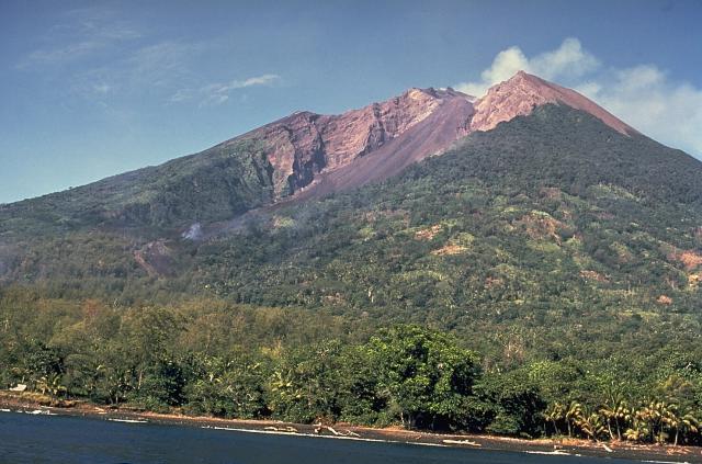
The 10-km-wide island of Manam, lying 13 km off the northern coast of mainland Papua New Guinea, is one of the country’s most active volcanoes. Four large radial valleys extend from the unvegetated summit of the conical basaltic-andesitic stratovolcano to its lower flanks. These valleys channel lava flows and pyroclastic avalanches that have sometimes reached the coast. Five small satellitic centers are located near the island’s shoreline on the northern, southern, and western sides. Two summit craters are present; both are active, although most observed eruptions have originated from the southern crater, concentrating eruptive products during much of the past century into the SE valley. Frequent eruptions, typically of mild-to-moderate scale, have been recorded since 1616. Occasional larger eruptions have produced pyroclastic flows and lava flows that reached flat-lying coastal areas and entered the sea, sometimes impacting populated areas.
Sources : 3.nhk.or.jp , GVP.
Photo : Wally Johnson (Australia Bureau of Mineral Resources).
Colombia , Nevado del Ruiz :
Subject: Nevado del Ruiz volcano activity bulletin.
The level of activity continues at the Yellow Activity Level or (III): changes in the behavior of volcanic activity.
Regarding the monitoring of the activity of the Nevado del Ruiz volcano, the COLOMBIAN GEOLOGICAL SERVICE reports that:
Seismicity related to fluid dynamics inside volcanic conduits showed a slight decrease in the number of earthquakes and maintained similar levels in released seismic energy, compared to the previous week. This seismic activity was characterized by the occurrence of continuous volcanic tremors, pulses of tremors, some with spasmodic characteristics, long-period and very long-period type earthquakes. In general, these signals exhibited moderate to low energy levels, variable spectral content, and were located primarily within Arenas Crater. Thanks to the cameras installed in the area of the volcano and the report of the officials of the National Natural Park of Los Nevados, the gas and ash emissions associated with some of these signals have been confirmed.
Likewise, thanks to the FLIR cameras of the volcanic monitoring network, significant changes in the relative temperature of the emitted materials have been observed.
The seismicity generated by the fracturing of the rocks showed a slight increase in the number of earthquakes and a decrease in the seismic energy released, compared to the previous week. This seismic activity was located mainly in the Arenas crater and in the northeast and distal southeast sectors (≈10.8 km from the crater) and, to a lesser extent, in the southwest sector of the volcano. The depth of the earthquakes varied between 0.4 and 6.0 km. The maximum magnitude recorded during the week was 1.1 ML (Local Magnitude), corresponding to the earthquake recorded on March 4 at 4:58 p.m. (local time), located 4.1 km northeast of the Arenas crater, at a depth of 3.3 km.
During the week, there were 11 low-energy, short-to-moderate drumbeat-type seismicity episodes, which were recorded on March 1.
Source : SGC.
Photo : Sylvain Chermette ( 80 Jours Voyages)


No comment yet, add your voice below!