
March 02 , 2022 .
Italy / Sicily , Etna :
WEEKLY BULLETIN, from February 21, 2022 to February 27, 2022. (issue date March 01, 2022)
ACTIVITY STATUS SUMMARY
In the light of the surveillance data, it is highlighted:
1) VOLCANOLOGICAL OBSERVATIONS: Strombolian activity and lava fountain of the Southeast Crater; degassing of the Bocca Nuova crater and the Voragine crater; degassing and ash emissions from the Northeast Crater.
2) SEISMOLOGY: Low seismic activity of fracturing; average amplitude of volcanic tremor generally on low and medium levels, with the exception of the lava fountain on February 21, when very high values were reached.
3) INFRASOUND: Weak infrasonic activity, with the exception of the February 21 lava fountain, when the infrasonic signals reached very high values.
4) GROUND DEFORMATIONS: The ground deformation monitoring networks have observed variations in the time series compared to the February 21 paroxysmal episode.
In particular, the tilt network showed variations of modest amplitude with a maximum variation of about 5.2 microradians measured at the ECP (Crater del Piano) station.
5) GEOCHEMISTRY: SO2 flux at a medium-low level and moderately increasing.
The soil CO2 flux shows average values with an upward trend recorded over the last three days.
The partial pressure of dissolved CO2 in the aquifer shows values in seasonal variability.
No update is available regarding the isotopic ratio of Helium (peripheral gases). The latest data from February 15, 2022 indicated high values of the isotope ratio (0.66).
6) SATELLITE OBSERVATIONS: Thermal activity in the summit area was at a low level after the February 21, 2022 lava fountain.
7) OTHER NOTES: The composition of volcanic glass from the February 10-21, 2022 eruption indicates that new magma has begun to enter the magmatic « reservoir » that feeds the Southeast Crater.
VOLCANOLOGICAL OBSERVATIONS
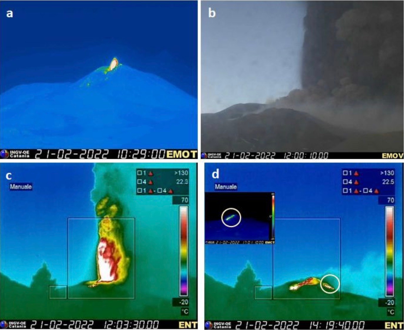
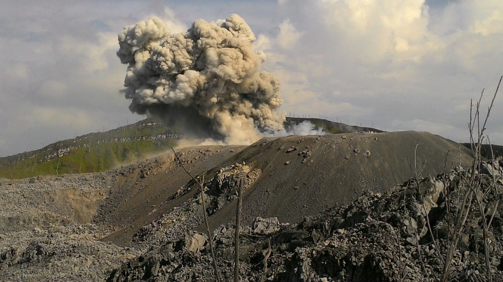
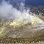
During the week, the monitoring of the volcanic activity of Etna was carried out by analyzing the images of the surveillance cameras of the INGV, the Osservatorio Etneo (INGV-OE) and the staff of the INGV in the field. Due to the unfavorable weather conditions that characterized several days of the week, the observation of volcanic activity from the cameras was discontinued. Figure 3.1 shows the summit area of Etna with the lava flows produced by the southeast crater (SEC) on the morning of February 21 and the table at the base shows the quantitative characterization of the flows. The mapping of the lava flows was obtained by processing Sentinel-2 and PlanetScope satellite images, and GPS measurements made in the field by INGV staff. The figure also explains the Bocca Nuova (BN), Voragine (VOR) and Northeast Crater (NEC) crater and their state of activity.
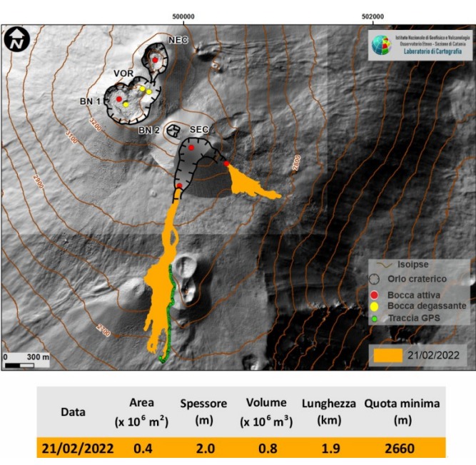
Map of the summit area of Etna on a shaded model of the terrain, flows and morphological characterization of the rim of the Southeast Crater. The map was established by integrating the analyzes of Sentinel-2 and PlanetScope satellite images, respectively on February 23 and 24, and the GPS track acquired by INGV staff on February 24, 2022.
In general, in the period studied, the activity of Etna was characterized by an episode of lava fountaining at the Southeast Crater, by intra-crater Strombolian activity and ash emissions at the Southeast Crater, by degassing and ash emission at the Northeast Crater, by intense degassing at Bocca Nuova and fumarolic degassing at the Voragine crater.
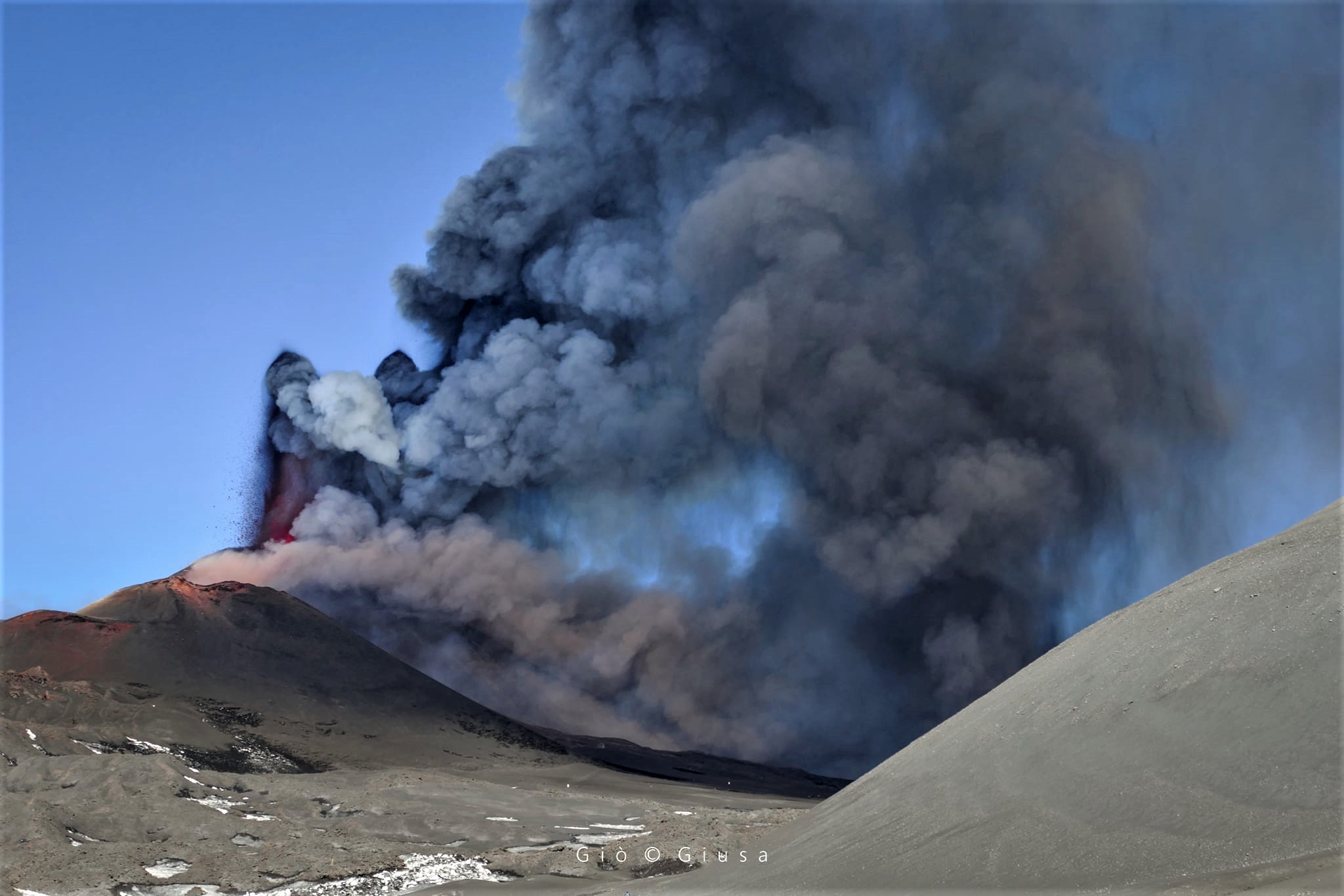
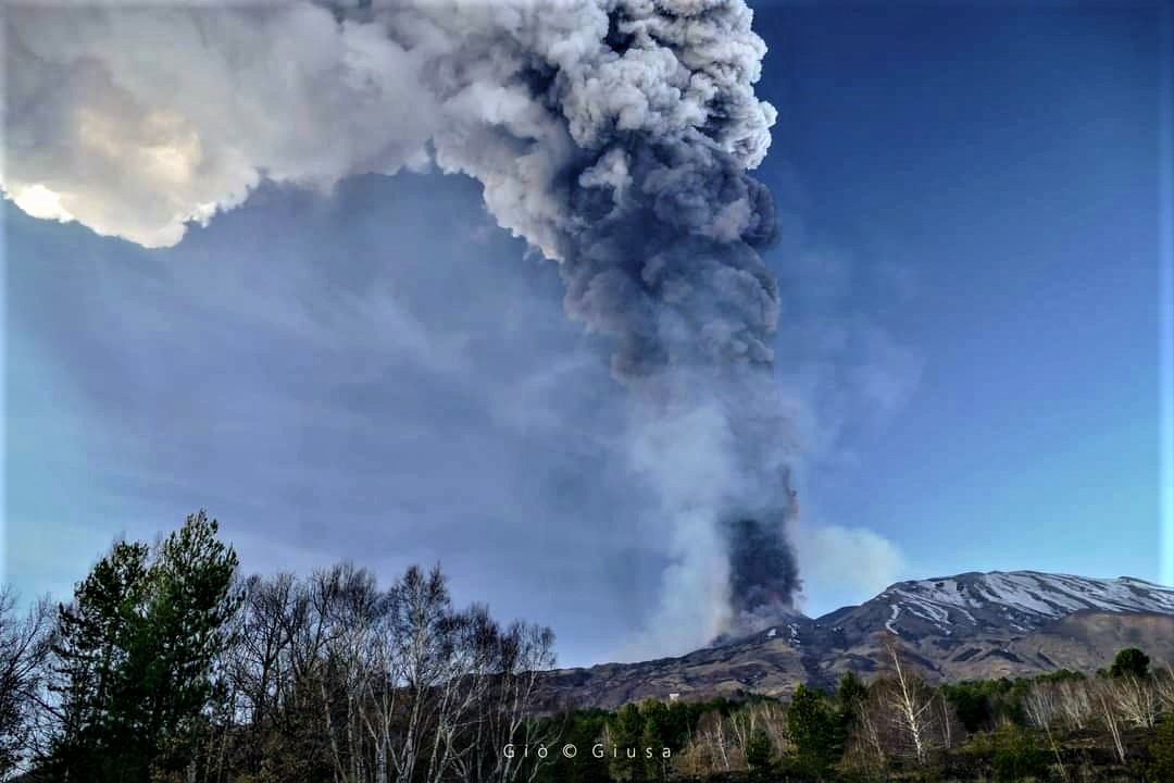
In detail, on February 21 the Southeast Crater was characterized by the resumption of Strombolian activity from the early hours of the morning which produced discreet emissions of ash which dispersed near the summit area. Strombolian activity intensified from about 10:40 UTC, fueling a volcanic cloud that dispersed in a SE direction. In less than half an hour, the Strombolian activity turned into a fountain of lava which, while intensifying, produced an eruptive column which at 11:20 UTC had reached a height of 10 km above the level from the sea, always expanding towards the South-East. In addition, from 11:05 UTC, the formation of a lava overflow was observed which, from the southern slope of the Southeast Crater, propagated in a southwesterly direction. At around 12:40 UTC, the fountain episode was over, having produced a volcanic cloud that had reached an estimated maximum height of about 12 km. Strombolian activity, which still persisted, gradually ceased around 12:50 UTC.
From direct observations made in the field, INGV-OE staff reported that the dispersion of the eruptive cloud in the Southeast sector had experienced volcanic ash fallout on the localities of Viagrande, Trecastagni, Milo, Acicastello, with the main axis of dispersion between Petrulli and Zafferana. Regarding the effusive activity, at 13:00 UTC, the lava flow that propagated in the direction of the Southwest was still fed, while from 14:00 UTC, the surveillance cameras and the personnel of the INGV-OE on the ground reported another lightly fed lava flow that propagated along the eastern side of the Southeast Crater, the front of which was at an estimated elevation of approximately 2900 m. At 18:00 UTC, both lava flows appeared to be poorly fed. On February 22, due to unfavorable weather conditions, the observation of the state of activity was only possible from approximately 18:00 UTC. From the images of the cameras, it was observed that a weak intra-crater Strombolian activity still persisted at the Southeast Crater and also the presence of a lava flow which spread along the eastern slope of the crater .
Subsequently, in the days of February 23 to 25, the weak Strombolian activity produced sporadic and occasional ash emissions which quickly dispersed around the summit area; in particular the most energetic were observed on February 23 at 10:14, 10:17 and 14:19 UTC (scattering in the South-South-South-West direction), on February 24 at 08:00 UTC (scattering in the South-South-East direction) and February 25 at 3:07 p.m., 4:49 p.m. and 4:51 p.m. UTC (scattering towards South-South-East). Regarding effusive activity, on the morning of the 23rd, the lava flow from the evening before appeared already cooling. Finally, during the week, following the episode of the lava fountain of the morning of the 21st, several modest collapses were observed within the southern breach of the Southeast Crater and on the upper eastern slope, which caused very dilute puffs of ash.
During the week, the Northeast Crater was characterized by ordinary degassing. On the morning of February 24, the degassing showed an impulse regime which at 12:38 UTC produced an intense emission of ash, followed by impulses of lesser magnitude, which propagated in the atmosphere in the South-South-East direction. A second minor emission, whose emitted ashes were very dilute, was recorded at 15:42 UTC on the same day. The Bocca Nuova crater was characterized by continuous and intense, sometimes pulsatile degassing and sporadic emissions of very dilute ash. The Voragine crater produced a fumarolic degassing.
Source : INGV.
Photos : Gio Giusa , INGV , INGV. Gio Giusa .
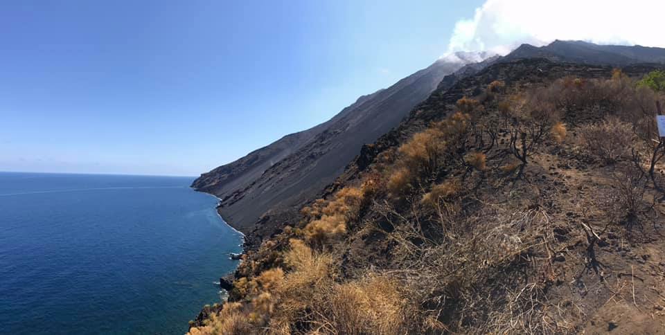
Italy , Stromboli :
WEEKLY BULLETIN, from February 21, 2022 to February 27, 2022. (issue date March 01, 2022)
ACTIVITY STATUS SUMMARY
In the light of the surveillance data, it is highlighted:
1) VOLCANOLOGICAL OBSERVATIONS: During this period, normal explosive activity of the Strombolian type was observed with projection activity in the N zone. The total hourly frequency of explosions fluctuated between medium-low values (9 events/h) and low values (4 events/h). The intensity of the explosions was mainly medium to low in the area of the North crater and low in the area of the Center-South crater.
2) SEISMOLOGY: The seismological parameters monitored do not show any significant variations.
3) GROUND DEFORMATIONS: Stromboli’s ground deformation monitoring networks have not shown any significant changes over the past week.
4) GEOCHEMISTRY: SO2 flow at an average and decreasing level.
CO2 flux in the crater area on high values.
There are no updates regarding the C/S value in the plume; the latest data indicated medium to high values.
There are no updates regarding the isotope ratio of helium.
5) SATELLITE OBSERVATIONS: The thermal activity observed by satellite was at a low level.
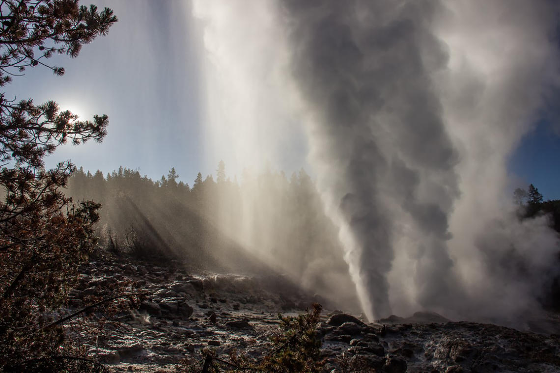
VOLCANOLOGICAL OBSERVATIONS
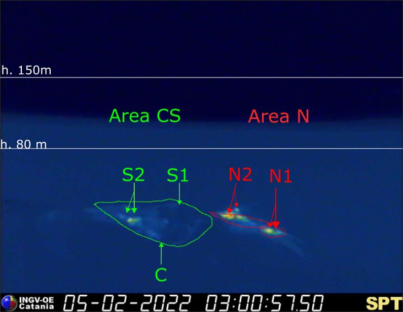
During the observation period, the eruptive activity of Stromboli was characterized through the analysis of images recorded by the INGV-OE surveillance cameras (altitude 190m, Punta Corvi, altitude 400m and Pizzo) . The explosive activity was mainly produced by 3 (three) eruptive vents located in the North crater area and 3 (three) eruptive vents located in the Center-South crater area. All the mouths are placed inside the depression which occupies the terrace of the crater.
Due to unfavorable weather conditions on February 21 and 26, 2022, the visibility of the crater terrace was insufficient for a correct description of the eruptive activity.
The N1 sector located in the area of the North crater produced explosions of variable intensity from low (less than 80 m high) to strong (more than 150 m high) emitting fine materials (ash) sometimes mixed with materials coarse (lapilli and bombs). Sector N2, with two emission points, showed low intensity explosive activity (less than 80 m in height) emitting coarse materials with discontinuous and weak projection activity. The average frequency of explosions varied from 2 to 5 events/h.
In the Center-South zone, sectors C and S1 did not show significant explosive activity. Sector S2, with two emission points, had low intensity explosions (the products of the explosions did not exceed 80 m in height) emitting coarse materials. The frequency of explosions varied between 4 and 9 events/h
Source : INGV.
Photos : INGV , LGS – Laboratorio Geofisica Sperimentale.
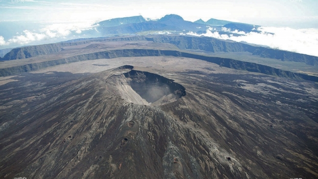
La Réunion , Piton de la Fournaise :
Seismicity:
In February 2022, the OVPF recorded at the level of the Piton de la Fournaise massif in total:
• 58 superficial volcano-tectonic earthquakes (0 to 2.5 km above sea level) under the summit craters;
• 1 deep earthquake (below sea level);
• 401 collapses (in the Cratère Dolomieu, the ramparts of the Enclos Fouqué and the Piton de Crac, and of the Rivière de l’Est).
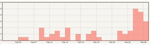
Figure 1: Histogram representing the number of superficial volcano-tectonic earthquakes recorded in February 2022 (©OVPF-IPGP).
Seismicity under the Piton de la Fournaise during the month of February 2022 remained low with an average of two superficial volcano-tectonic earthquakes per day. A slight increase should be noted since February 26 with an average of 8 superficial volcano-tectonic earthquakes per day over the last three days of the month.
The month of February was also marked by numerous landslides (in the Cratère Dolomieu, the ramparts of the Enclos Fouqué and the Piton de Crac, and the Rivière de l’Est) following the passage of cyclones Batsirai and Emnati at most near Réunion, on 2-4 February and 20-21 February respectively.
Deformation:
After the end of the eruption on January 17, 2022, a slight recovery in peak inflation was recorded. Since the beginning of February, this inflation has slowed down considerably and even seems to no longer be recorded on certain stations. This parameter will be confirmed next month.
Geochemistry of gases.
CO2 concentration in the soil
Following the eruption of December 2020, a continuous increase in CO2 emissions from the ground was recorded at the level of the distal sites (Plaine des Cafres sectors) but also proximal (Gîte du volcan).
At remote sites, a reversal of trends (decline in CO2 emissions) occurred on February 12, 2021, witnessing a possible transfer of magma to more superficial crustal levels.
Source : OVPF.
Read the article: https://www.ipgp.fr/sites/default/files/ovpf_20220301_bullmensu.pdf
Photo : IPR
Indonesia , Ibu :
The volcano is clearly visible until it is covered in fog. Smoke from the crater is white / gray with low to moderate intensity, about 200-800 meters above the summit. The weather is sunny to rainy, the wind is light to moderate in the East and North-West. There were eruptions and avalanches, but visually the distance and direction of the slide was not observed.
Volcanic earthquakes are associated with magmatic, surface and tectonic activity. It was recorded:
– 72 eruption earthquakes/explosions
– 53 avalanche earthquakes
– 26 emission earthquakes
– 3 harmonic tremors
– 30 shallow volcanic earthquakes
– 2 distant tectonic earthquakes.
VOLCANO OBSERVATORY NOTICE FOR AVIATION – VONA
Issued : March 02 , 2022
Volcano : Ibu (268030)
Current Aviation Colour Code : ORANGE
Previous Aviation Colour Code : orange
Source : Ibu Volcano Observatory
Notice Number : 2022IBU09
Volcano Location : N 01 deg 29 min 17 sec E 127 deg 37 min 48 sec
Area : North Maluku, Indonesia
Summit Elevation : 4240 FT (1325 M)
Volcanic Activity Summary :
Eruption with volcanic ash cloud at 00h40 UTC (09h40 local).
Volcanic Cloud Height :
Best estimate of ash-cloud top is around 6800 FT (2125 M) above sea level, may be higher than what can be observed clearly. Source of height data: ground observer.
Other Volcanic Cloud Information :
Ash-cloud moving to west.
Remarks :
Eruption and ash emission is continuing.
Sources : PVMBG , Magma Indonésie.
Photo : John Massolo – WordPress.com.
United – States , Yellowstone :
44°25’48 » N 110°40’12 » W,
Summit Elevation 9203 ft (2805 m)
Current Volcano Alert Level: NORMAL
Current Aviation Color Code: GREEN
Recent work and news
Steamboat Geyser continues to be active in 2022, although the frequency of its eruptions has decreased dramatically compared to the preceding 3 years. The geyser experienced one major water eruption in the past month, on February 14—the second major water eruption of the year. As of the end of February, minor eruptive activity has resumed, suggesting that another major water eruption will occur in the coming weeks.
Seismicity
During February 2022, the University of Utah Seismograph Stations, responsible for the operation and analysis of the Yellowstone Seismic Network, located 83 earthquakes in the Yellowstone National Park region. The largest event of the month was a minor earthquake of magnitude 2.8 located ~3 miles north-northeast of Lake in Yellowstone National Park on February 8 at 4:43 AM MST.
February seismicity in Yellowstone included a sequence of 23 earthquakes that occurred during February 11-12 (MST) in the area about 2 miles south-southwest of Old Faithful. The largest swarm event was a micro earthquake of magnitude 1.9 on February 12 at 2:42 AM (MST). Earthquake sequences like these are common and account for roughly 50% of the total seismicity in the Yellowstone region.
Yellowstone earthquake activity remains at background levels.
Ground deformation
No significant changes in ground deformation patterns were observed in data from continuous GPS stations over the past several months. No deformation is apparent in a station near Norris Geyser Basin, and stations within Yellowstone Caldera continue to subside at an overall rate of 2-3 cm (1 in) per year. This subsidence has been ongoing since 2015.
Source : YVO.
Photo : Steamboat / Mara Reed .
Colombia , Nevado del Ruiz :
Bulletin of activity level of the Nevado del Ruiz volcano.
The level of activity continues at the Yellow Activity Level or (III): changes in the behavior of volcanic activity.
Regarding the monitoring of the activity of the Nevado del Ruiz volcano, the COLOMBIAN GEOLOGICAL SERVICE reports that:
Seismicity related to fluid dynamics inside volcanic conduits showed an increase in the number of earthquakes and released seismic energy, compared to the previous week.
This seismic activity was characterized by the occurrence of continuous volcanic tremors, harmonic tremors, pulses of tremors, some with spasmodic characteristics, earthquakes of long period and very long period types. In general, these signals exhibited moderate to low energy levels, variable spectral content, and were located primarily within Arenas Crater. According to cameras installed in the volcano area and reports from Los Nevados National Natural Park officials, confirmation of gas and ash emissions associated with some of these signals has been made. Likewise, thanks to the FLIR cameras of the volcanic monitoring network, significant changes in the relative temperature of the emitted material have been observed.
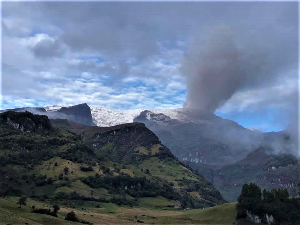
The seismicity generated by the fracturing of the rock increased in number of earthquakes and released seismic energy, compared to the previous week. This seismic activity was located mainly in the Arenas crater and in the south and south-east sectors of the volcano and, to a lesser extent, in the north-east and south-west sectors. The depth of the earthquakes varied between 0.6 and 4.8 km. The maximum magnitude recorded during the week was 1.5 ML (Local Magnitude), corresponding to the earthquake recorded on February 24 at 09:57 (local time), located in the Arenas crater, at a depth of 1.8 km.
During the week, there were 11 episodes of low-energy « drumbeat » type seismicity, which were recorded on February 23, 26 and 28, with the 23rd being the day when the greatest increase in the number of this seismicity was observed.
Source : SGC.
Photo : Ramirez Jorge.


No comment yet, add your voice below!