
February 28 , 2022.
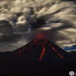
Hawaii , Kilauea :
19°25’16 » N 155°17’13 » W,
Summit Elevation 4091 ft (1247 m)
Current Volcano Alert Level: WATCH
Current Aviation Color Code: ORANGE
Activity Summary:
The summit eruption of Kīlauea Volcano, within Halemaʻumaʻu crater, is currently paused, corresponding with deflationary tilt and a drop in volcanic tremor. All recent lava activity has been confined to the crater, and there are no indications of activity migrating elsewhere on Kīlauea.
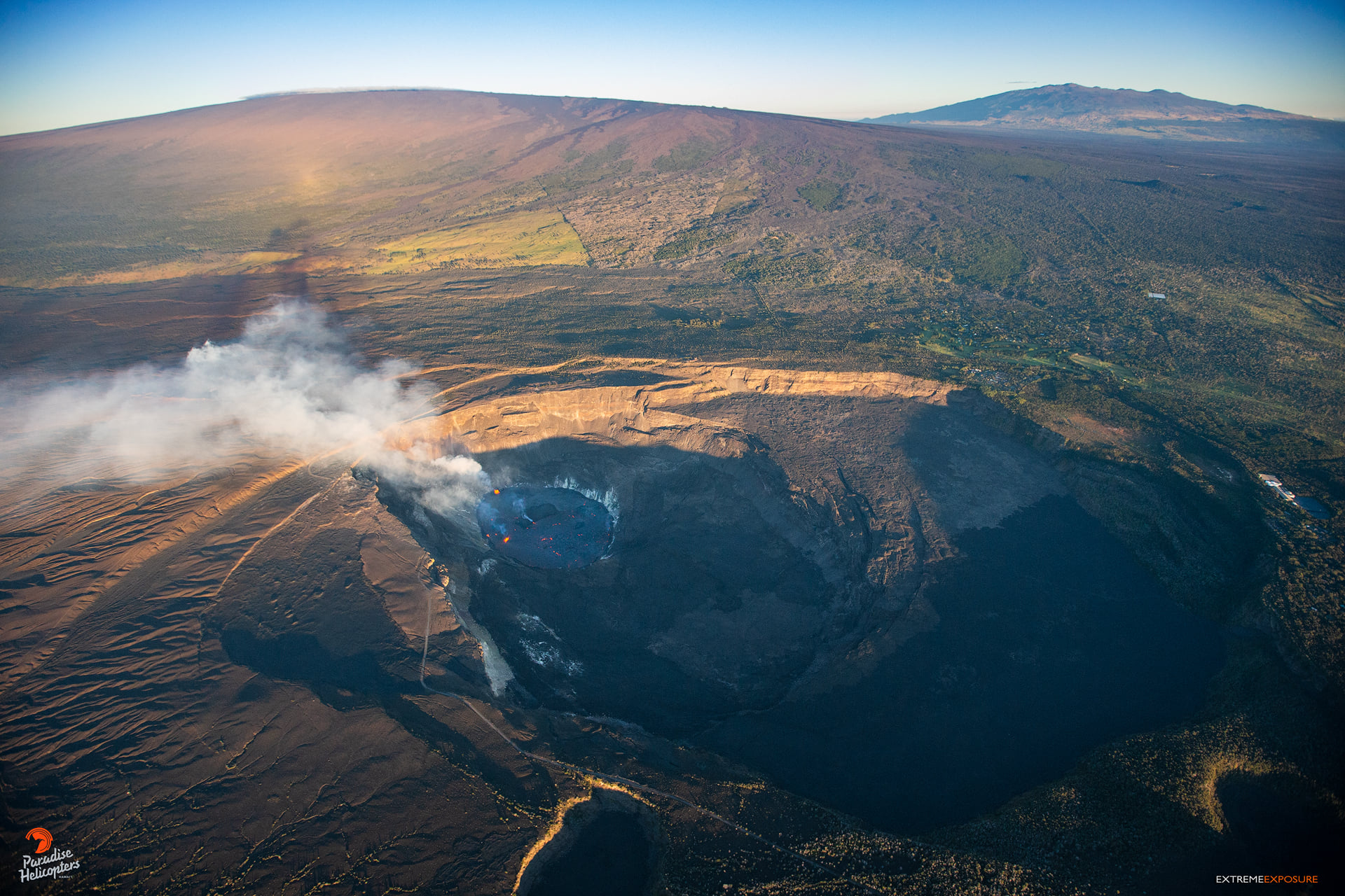
Halemaʻumaʻu Lava Lake Observations:
Effusion of lava began diminishing around 10:45 am HST yesterday and reached a full pause by approximately 3 pm HST. Eruption of lava from the western vent into the active lava lake within Halemaʻumaʻu crater is currently fully paused. The active lava lake surface of Halemaʻumaʻu crater has dropped approximately 6.5 meters (21 feet) over the last 24 hours. This corresponds with the deflationary signal that started in the early morning of February 25. The floor of Halemaʻumaʻu crater has risen approximately 96 meters (315 feet) since the eruption began on September 29, 2021. The erupted volume is 45 million cubic meters (59 million cubic yards) of lava as measured on January 25, 2021.
Summit Observations:
Over the last 24 hours, summit tilt was steady until approximately 5:00 am HST this morning when is started a steep inflationary trend that continues at the time of this update. Between approximately 5:00 am HST and 8:00 am HST today, summit tilt has increased by approximately 0.9 microradians. Seismic data shows that the volcanic tremor signal has remained low and steady over most of the past 24 hours after a decrease between approximately 8:00 and 9:00 am HST yesterday. Earthquake activity at the summit remains below background levels. A sulfur dioxide (SO2) emission rate of approximately ~2500 tonnes per day (t/d) was measured on February 25.
Source : HVO.
Photo : Bruce Omori.
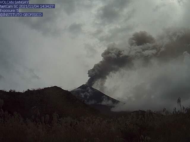
Ecuador , Sangay / Wolf :
DAILY REPORT OF THE STATE OF THE VOLCANO Sangay, Sunday February 27, 2022.
Information Geophysical Institute – EPN.
Surface activity level: High, Surface trend: Ascending.
Internal activity level: High, Internal trend: Ascending.
Seismicity: From February 26, 2022, 11:00 a.m. to February 27, 2022, 11:00 a.m.:
Due to reference station transmission problems, seismic event statistics are not available.
Rains / Lahars:
Light rain was recorded in the region. **In the event of heavy rains, these could remobilize the accumulated materials, generating mudslides and debris that would descend on the flanks of the volcano and flow into the adjacent rivers.**
Emission / ash column:
Two VAAC alerts were recorded with a height of 870 meters above crater level in a westerly direction.
Other Monitoring Parameters:
FIRMS registers 32 thermal alerts, while MIROVA registers 1 low thermal alert in the last 24 hours.
Observation:
Programs were recorded during the afternoon and evening. Due to persistent cloud cover in the area, there are no surface-level observations.
Alert level: Orange.
——————————————————————————————
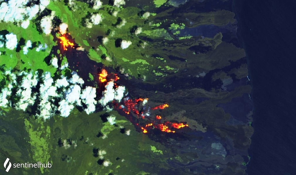
DAILY REPORT OF THE STATE OF WOLF VOLCANO. February 27, 2022.
Surface Activity Level: High, Surface Trend: Unchanged
Internal activity level: High, Internal trend: Downward.
Seismicity: From February 26, 2022, 11:00 a.m. to February 27, 2022, 11:00 a.m.:
Long Periods (LP) 1
Emission / ash column:
In the past 24 hours, there have been no reports from Washington’s VAAC
Other Monitoring Parameters:
WORLDVIEW records over 100 thermal alerts, while MIROVA records 2 high (575 and 528 MW) and 2 very high (1983 and 1826 MW) thermal alerts in the last 24 hours.
Observation:
Thermal anomalies continue to be seen in satellite images due to advancing lava flows.
Information on the La Cumbre volcano, Fernandina Island:
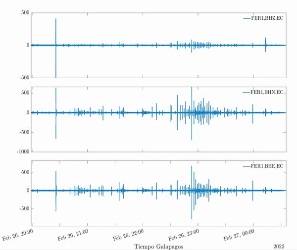
Since 8:25 p.m. Galapagos Time on February 26, 2022, the seismic stations FER1 and FER2 have been recording a seismic swarm which could be a premonitory of possible eruptive activity on the La Cumbre volcano located on Fernandina Island. So far no surface activity has been detected according to satellite images. The IG-EPN continues to monitor the event and will inform in due time if changes in the monitoring parameters are detected.
Source : IGEPN.
Photos : IGEPN ( Archive) , Sentinel hub , IGEPN.
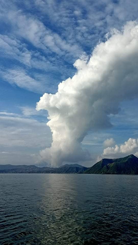
Philippines , Taal :
TAAL VOLCANO BULLETIN 28 February 2022 8:00 AM
In the past 24-hour period, the Taal Volcano Network recorded twenty-nine (29) volcanic tremor events having durations of two (2) to six (6) minutes. Activity at the Main Crater was dominated by upwelling of hot volcanic fluids in its lake which generated plumes 600 meters tall that drifted southwest. Sulfur dioxide (SO2) emission averaged 2,612 tonnes/day on 25 February 2022. Temperature highs of 63.7°C were last measured from the Main Crater Lake on 25 February 2022. Based on ground deformation parameters from electronic tilt, continuous GPS and InSAR monitoring, Taal Volcano Island and the Taal region has begun deflating in October 2021.
Alert Level 2 (Increased Unrest) prevails over Taal Volcano. DOST-PHIVOLCS reminds the public that at Alert Level 2, sudden steam- or gas-driven explosions, volcanic earthquakes, minor ashfall, and lethal accumulations or expulsions of volcanic gas can occur and threaten areas within and around TVI. DOST-PHIVOLCS strongly recommends that entry into Taal Volcano Island, Taal’s Permanent Danger Zone or PDZ must be strictly prohibited, especially the vicinities of the Main Crater and the Daang Kastila fissure, and extended stays on Taal Lake.
Source : Phivolcs
Photo : R. Olazo .
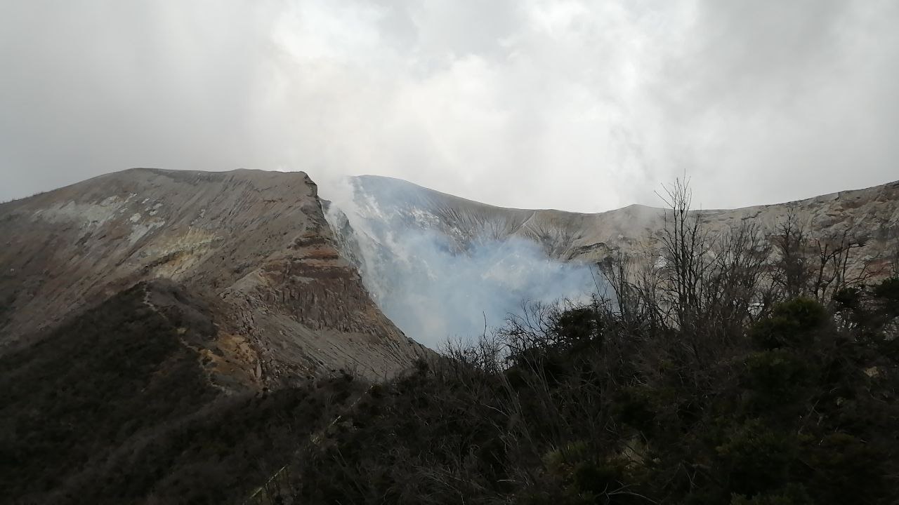
Costa Rica , Turrialba :
Turrialba volcano activity report, February 27, 2022.
On February 27, 2022 at 7:55 p.m. local time, an eruption is recorded at the level of the Turrialba volcano, with a column that rose 300 meters above the height of the crater and 3640 meters above sea level (11939.2 feet).
Duration of the activity: 1 minute.
The winds blow to the northeast.
Ash fall reported: No ash fall is reported
Sulfur odor reported: No sulfur odor reported
Comments: Small eruption with very diluted ash.
Degassing is observed in the crater. Yesterday, very dilute emissions of fine particles were observed. Frequent high and low frequency earthquakes are detected. In recent days, geodetic observations show no significant change. Gas ratios are in range for the past few days. A large peak in the SO2 concentration is observed, which could be a measurement artifact.
Source : Ovsicori.
Photo : Jean Paul Calvo, RSN.
La Réunion , Piton de la Fournaise :
Seismology
– Number of landslides of February 27, 2022: 19
Areas affected by landslides:
Summit cone
Enclos
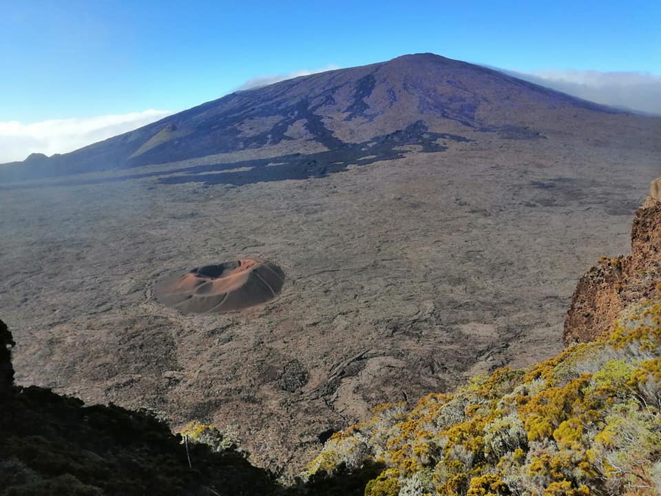
– Number of volcano-tectonic earthquakes (VT) of February 27, 2022: 9
Area affected by VTs: Summit cone
– Volcano-tectonic earthquake of greater magnitude of February 27, 2022:
Duration: 9.04s
Duration magnitude: 1.04.
Deformations
– The GPS in the summit area does not record any particular signals.
– Far-field GPS devices do not record specific signals.

Geochemistry
SO2 emissions: below detection limit
CO2 emissions by the ground: decreasing in the distal sector and in the sector of the volcano lodge.
Source : OVPF.
Photos : Nath Duverlie , OVPF.


No comment yet, add your voice below!