
February 24 , 2022 .
New Zealand , White Island :
Whakaari/White Island: Volcanic unrest continues with some minor ash emission and vent changes . Published: Wed Feb 23 2022 11:45 AM
Volcanic Alert Level remains at 2
Aviation Colour Code remains at Yellow
An observation flight last week (17 February 2022) has confirmed that dilute ash emission continues from the 2019 active vent and the area of geysering activity has developed to form a pit crater. Data obtained from the improved transmission data link also confirms the state of moderate to heightened unrest. The Volcanic Alert Level remains at Level 2
On Thursday 17th GNS volcanologists undertook an observation flight over the island. This confirmed that a small amount of brown ash was being entrained in the steam and gas discharging from the 2019 active vent area. The dilute ash plume was not extending above the Main Crater wall. This is similar to many observations this year from flights and the web cameras.
The flight also confirmed that the area of geyser activity recently seen on the web cameras has developed into a shallow, mud-filled pit crater. Features like this are not unusual and this one has formed where steam and geyser activity has been noted in the past. Small scale steam explosions were ejecting mud that is building up a small dark grey cone around the crater.
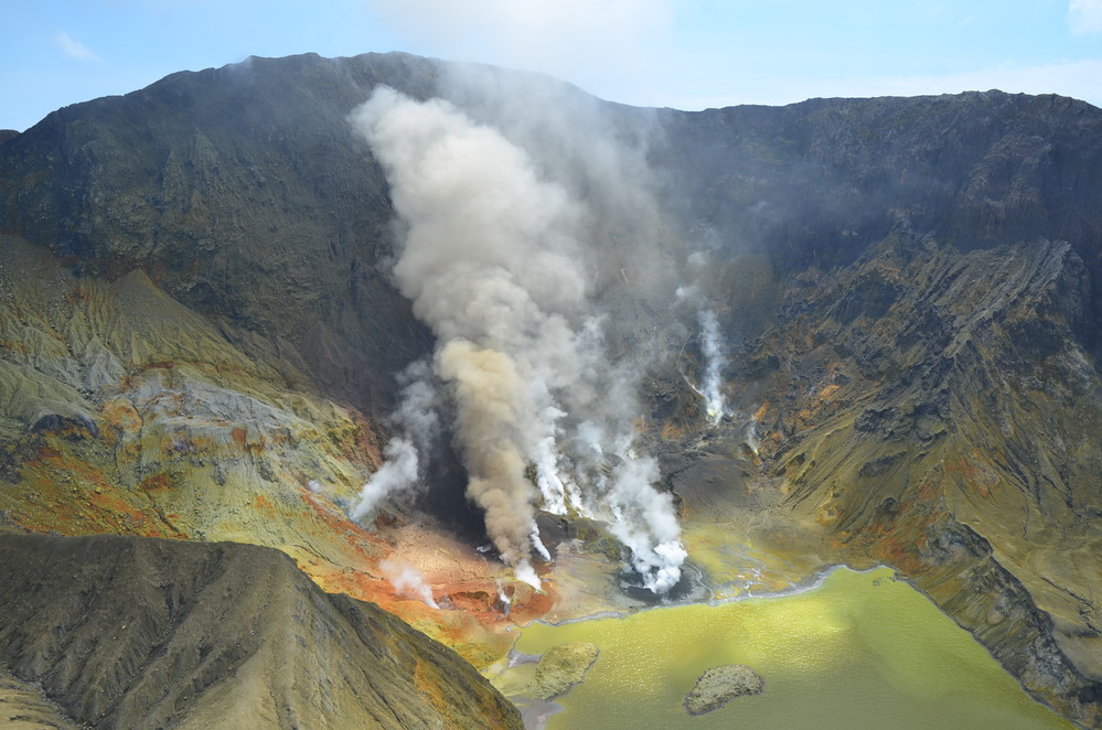
Aerial view of the active vents at Whakaari / White Island showing the dilute ash column and the new crater with dark grey muds around it. Bright colours are hydrothermal minerals precipitated in the lake and on the ground
FLIR thermal InfraRed data obtained during the flight established that high temperatures continue to be present in the gas and steam feeding the active vent. A maximum temperature of 435 °C was measured during the flight. A temperature of 172 °C was recorded from a different vent in the 2019 area. The water level of the lake has receded slightly in the past few weeks.
Overall, the conditions remain similar to those observed over the past few months, characterised by intermittent weak ash emissions, high steam and gas temperatures from the active vents and varying lake levels. When the lake level is high some vents can be drowned and the style of activity changes.
The current level of activity is consistent with moderate to heightened levels of unrest. As such the Volcanic Alert Level remains at 2 and the Aviation Colour Code remains at Yellow.
As noted previously, our on-island equipment has degraded over the past two years. However, recent improvements of the transmission of data means that some of the data is more continuous and more complete than it has been recently.
The Volcanic Alert Level reflects the current level of volcanic unrest or activity and is not a forecast of future activity. While Volcanic Alert Level 2 is mostly associated with volcanic unrest hazards (including discharge of steam and hot volcanic gases, earthquakes, landslides, and hydrothermal activity), potential for eruption hazards also exists and eruptions can still occur with little or no warning.
Source et photo : Geonet / Mike Rosenberg Volcanologue de service .
Japan , Mount Ontake / Aso :
Mount Ontake :
Japan’s weather agency on Wednesday raised its alert level for Mt. Ontake in the central part of the country, warning against going near its crater as volcanic earthquakes have increased.
The level-2 alert for the 3,067-meter volcano straddling Nagano and Gifu prefectures is the first since Aug. 21, 2017, with the Japan Meteorological Agency warning about the possibility of flying rocks around the 1-kilometer area from the crater on the mountain’s summit.
It was moved up from level 1, meaning « potential increased activity. » The agency has a five-scale volcanic alert system.
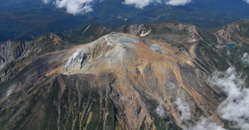
Photo taken Sept. 23, 2018, from a Kyodo News helicopter shows Mt. Ontake in central Japan.
The volcano straddling Nagano and Gifu prefectures erupted Sept. 27, 2014, killing 58 people and leaving five more unaccounted for.
On Wednesday, there were 80 tremors between 2 p.m. and 3 p.m. caused by volcanic activity, and slight swelling of the mountain was observed around its highest peak, according to the agency.
Since 2014, climbers have not been allowed on the mountain during the winter season.
Mount Aso
Japan’s Meteorological Agency raised the volcanic alert for Mount Aso, in southwestern Japan, after detecting an increase in tremors in the volcano Thursday morning.
The agency declared a Level 3 volcanic alert in the area, on a scale where the maximum is 5, urging the population not to approach the vicinity of the volcano due to the risk of an eruption and the expulsion of pyroclastic flows and rockfall within a radius of 2 kilometers.
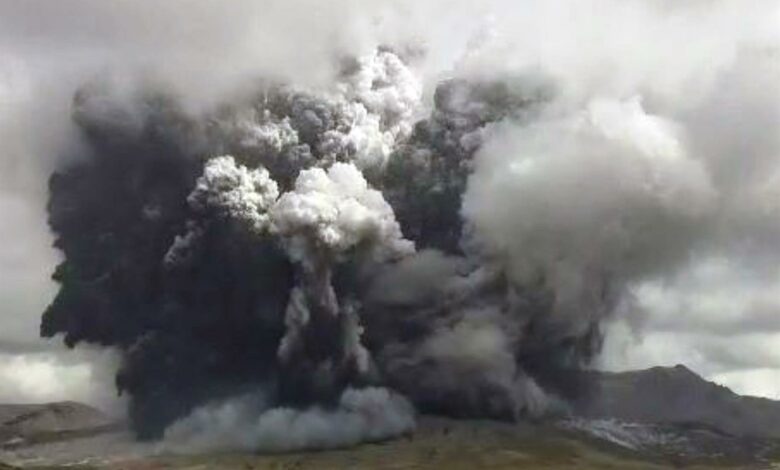
Mount Aso, in the Kumamoto prefecture, erupted on Oct. 20 and although it did not record human or material damage, expelled smoke that traveled more than 1 kilometer around it and reached heights of up to 3,500 meters.
After the eruption four months ago, Japanese authorities maintained the alert at Level 3, but lowered it to Level 2 on Nov. 18.
Mount Aso, about 1,600 meters high, is located in a sparsely populated area within a national park on the island of Kyushu, in southwestern Japan.
Sources :Kyōdo news. laprensalatina.com.
Photo : Kyōdo news. Efe .
Italy , Vulcano / Etna :
WEEKLY BULLETIN, from February 14, 2022 to February 20, 2022. (issue date February 22, 2022)
ACTIVITY STATUS SUMMARY
In the light of the surveillance data, it is highlighted:
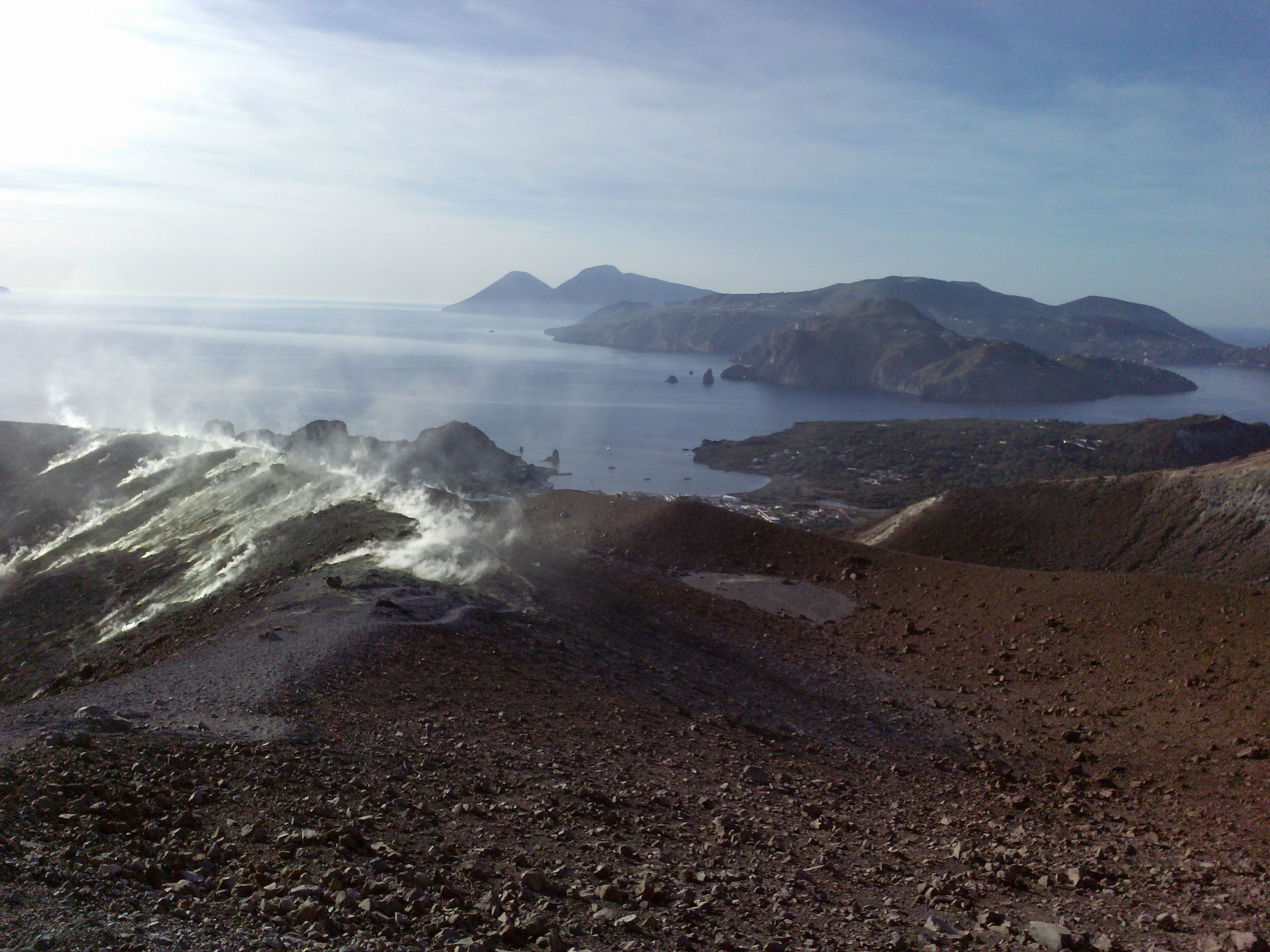
1) Temperature of the crater fumaroles: The updated data of the temperatures recorded on the edge of the crater show stable values and confirm the continuation of the thermal anomaly.
2) CO2 flux in the crater area: The CO2 flux in the crater area remains at high values.
3) SO2 flux in the crater area: SO2 flux at a high and decreasing level
4) Geochemistry of fumarolic gases: No update is available.
5) CO2 fluxes at the base of the La Fossa cone and in the Vulcano Porto area: The CO2 fluxes at the base of the crater remain at medium to high values, during the last two days there has been a increase in values on the peripheral areas of Camping Sicilia, Rimessa and P4 max, with the exception of the Faraglione site, where values close to the background level are recorded.
6) Geochemistry of thermal aquifers: The physico-chemical parameters recorded in the Camping Sicilia and Bambara wells remain stable at high values while showing a very slight decrease.
7) Local seismicity: low occurrence rate of local events.
8) Regional seismicity: No earthquake with Ml >= 1.0 was located in the week in question in the area of the island of Vulcano.
9) Deformations – GNSS: The GNSS surveillance network does not present substantial variations
10) Deformations – Inclinometry: During the week relating to this press release, the signals from the network of inclination sensors of Vulcano do not show any significant changes.
11) Other observations: Mobile GNSS: The mobile GNSS stations do not seem to show significant variations during the period considered.
Gravimetry: During the reporting period, no significant gravimetric change was recorded.
Monthly CO2 flux campaign: a slight decrease in CO2 emissions is observed in the Vulcano Porto area.
Monthly well campaign: a stabilization of the temperature values of the dissolved carbonate species is observed in all the wells monitored.
GB-RAR: The GB-RAR monitoring results referring to the period December 14, 2021 – February 21, 2022, show a general stability of the area, with deformations along the LOS of less than 1 mm.
CO2 FLOW IN THE CRATER AREA:
The CO2 flux values on the ground in the summit zone on a daily average (VCSCS) show high values around 10262 g/m2/day, still on an order of magnitude higher than the averages recorded over the past 10 years. The average CO2 flux value (monthly average) for the month of February 2022 (updated to date) is 11244 g/m2/day. A stabilization of degassing at high values is therefore observed on a monthly scale, with a slight decrease compared to the previous month (January: 13354 g/m2/day).
Communication on the activity of Etna, February 23, 2022, 19:15 (18:15 UTC).
The National Institute of Geophysics and Volcanology, Osservatorio Etneo, announces that surveillance cameras show that intra-crater Strombolian activity at the level of the Southeast Crater, reported in the previous press release (Etna Release – Update n.550), has ceased and the lava flow that was observed yesterday, on the east side of the Southeast Crater, is cooling.
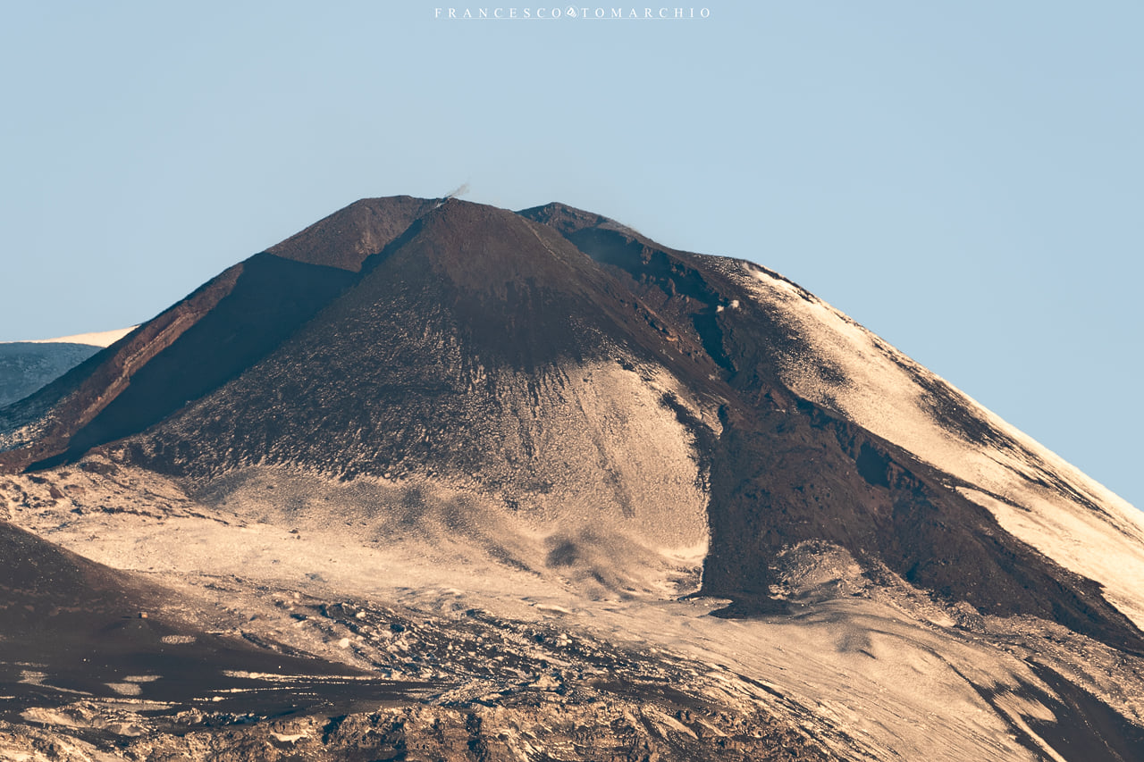
The average amplitude of the volcanic tremor is currently at a low level. The centroid of volcanic tremor sources is located in the Bocca Nuova crater area at an altitude of about 1500-2000 meters above sea level.
Infrasound activity remains low.
There are no significant changes in the deformation data recorded at the inclinometer and GNSS stations.
Further updates will be communicated soon.
Source : INGV.
Photos : Georges Vitton , Francesco Tomarchio .
Salomon Islands , Kavachi :
Satellite data showed discolored water around Kavachi in the month of February, on three of four image acquisition dates. Discolored water fanned out short distances (around 3 km) mainly to the E on 4 February and to the WSW on 14 February. Cloudy weather prevented views of the vent area on 9 February. On 19 February a relatively narrow plume of discolored water drifted E and then dispersed about 6 km away.
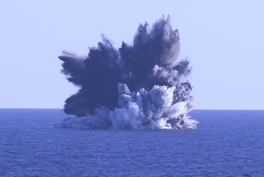
Named for a sea-god of the Gatokae and Vangunu peoples, Kavachi is one of the most active submarine volcanoes in the SW Pacific, located in the Solomon Islands south of Vangunu Island. Sometimes referred to as Rejo te Kvachi (« Kavachi’s Oven »), this shallow submarine basaltic-to-andesitic volcano has produced ephemeral islands up to 1 km long many times since its first recorded eruption during 1939. Residents of the nearby islands of Vanguna and Nggatokae (Gatokae) reported « fire on the water » prior to 1939, a possible reference to earlier eruptions. The roughly conical edifice rises from water depths of 1.1-1.2 km on the north and greater depths to the SE. Frequent shallow submarine and occasional subaerial eruptions produce phreatomagmatic explosions that eject steam, ash, and incandescent bombs. On a number of occasions lava flows were observed on the ephemeral islands.
Source : GVP.
Photo : Richard White/EYOS.
Tonga Islands , Hunga Tonga-Hunga Ha’apai :
Recovery efforts from the 14-15 January eruption of Hunga Tonga-Hunga Ha’apai continued in Tonga. According to a news article, the main undersea international fiber-optic communication cable that had been severed in multiple places due to the eruption had been repaired by 21 February, and internet connectivity was restored by 22 February. Repairs had begun on 3 February to rejoin 5-6 pieces and replace a 55 km section of the cable that was missing and likely buried in sediment.

A domestic cable that was located closer to the volcano may take months to repair. Another news article noted that over 200 fishing boats had been destroyed by the tsunamis; dozens of new boats had been gifted by international donors.
Source : GVP.
Photo : Hunga Tonga-Hunga Ha’apai , Tonga Geological Services, Government of Tonga.


No comment yet, add your voice below!