
February 22 , 2022.
Italy / Sicily , Etna :
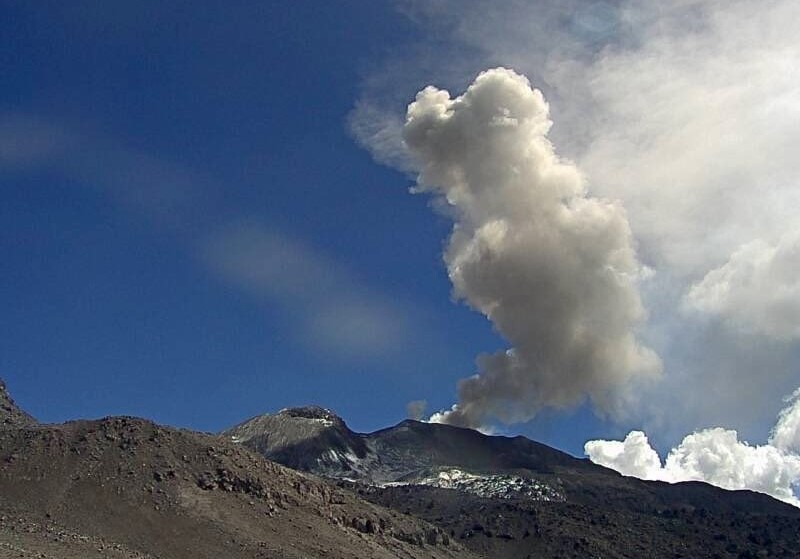
Communication on ETNA activity, February 21, 2022, 09:09 (08:09 UTC).
The National Institute of Geophysics and Volcanology, Osservatorio Etneo announces that the monitoring networks recorded a variation in the monitored parameters at 09:07 (08:07 UTC).
In particular, a thermal anomaly is observed from the surveillance cameras.
The anomaly occurs at the level of the Southeast Crater.
From the early hours of the morning, through the analysis of images from the INGV-OE surveillance cameras, a weak Strombolian activity at the level of the Southeast Crater is observed.
The average amplitude of the volcanic tremor, from about 08:00 UTC, gradually increases while remaining at the current state on the average level. The sources of the tremor are located under the Southeast Crater, about 2800-2900 m above sea level. Infrasonic activity is weak and localized near the Bocca Nuova crater.
The GNSS and inclinometer deformation monitoring networks show no significant changes.
February 21, 2022, 12:12 (11:12 UTC):
An increase in Strombolian activity is observed at the Southeast Crater. According to the forecast model, the volcanic cloud is dispersing towards the southeast sector.
February 21, 2022, 12:24 (11:24 UTC):
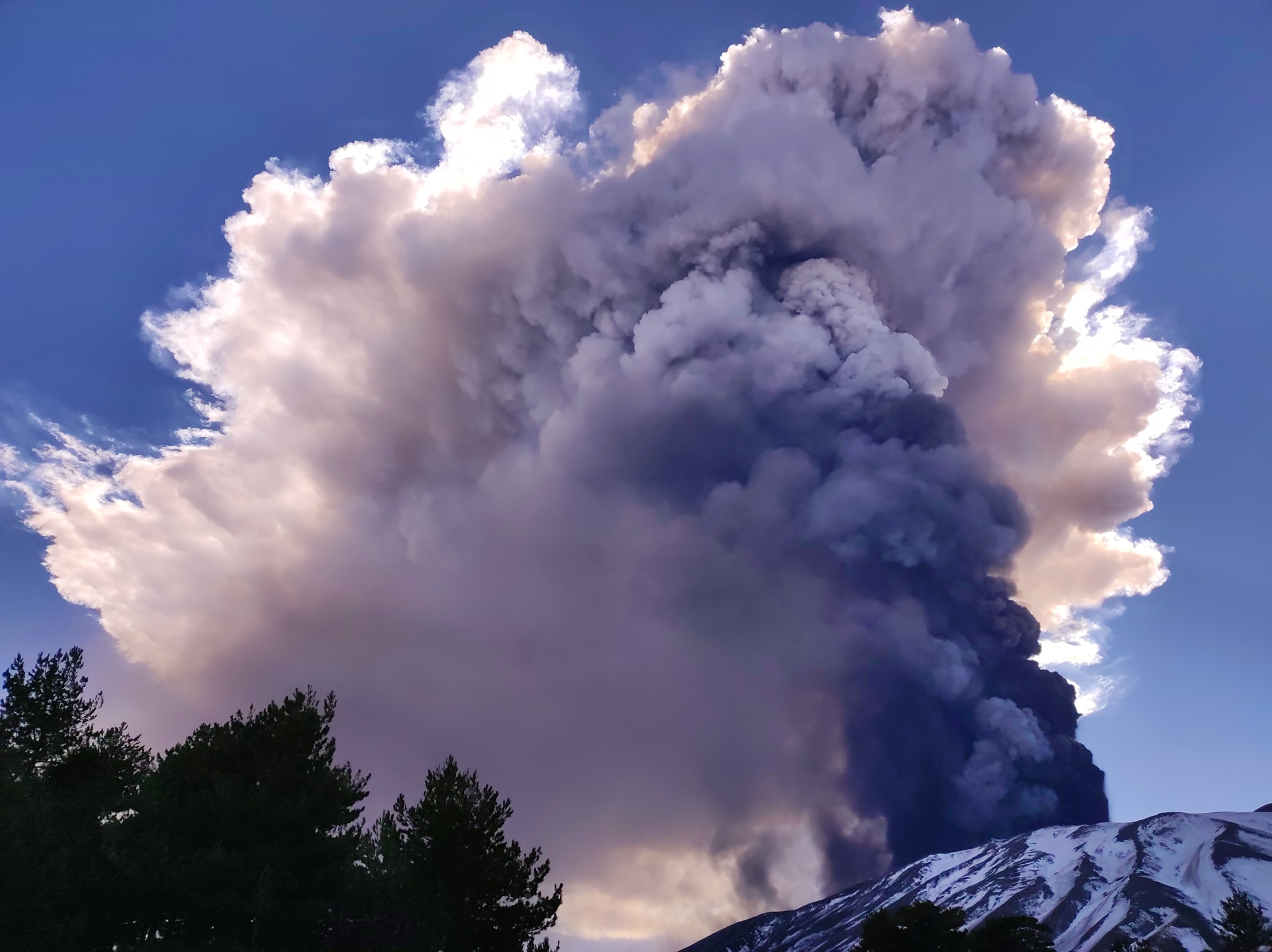
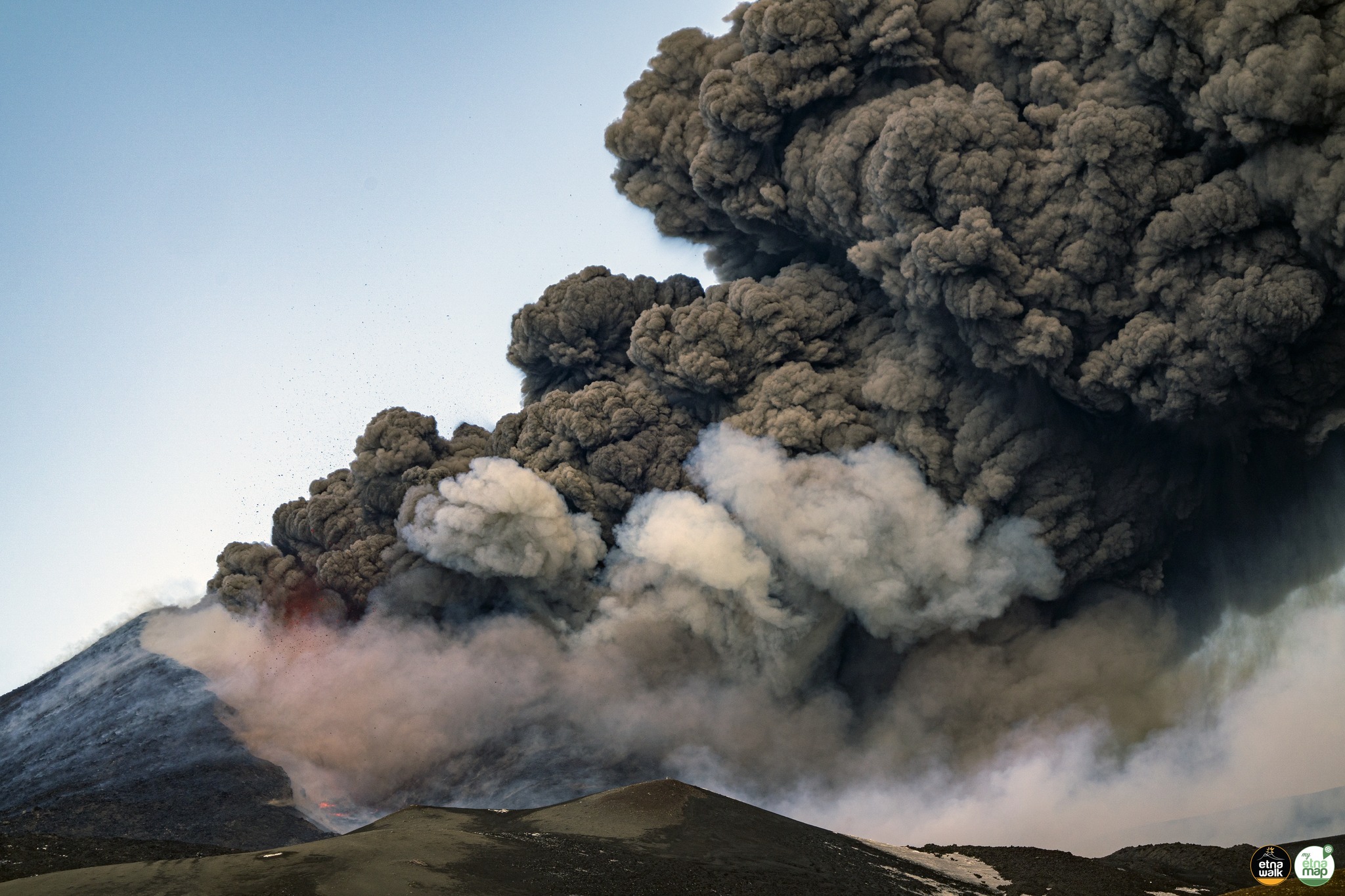
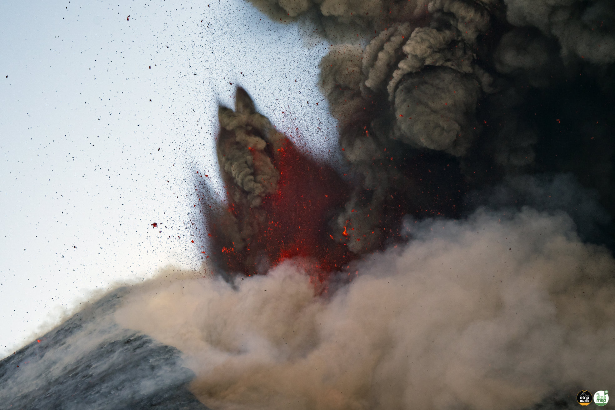
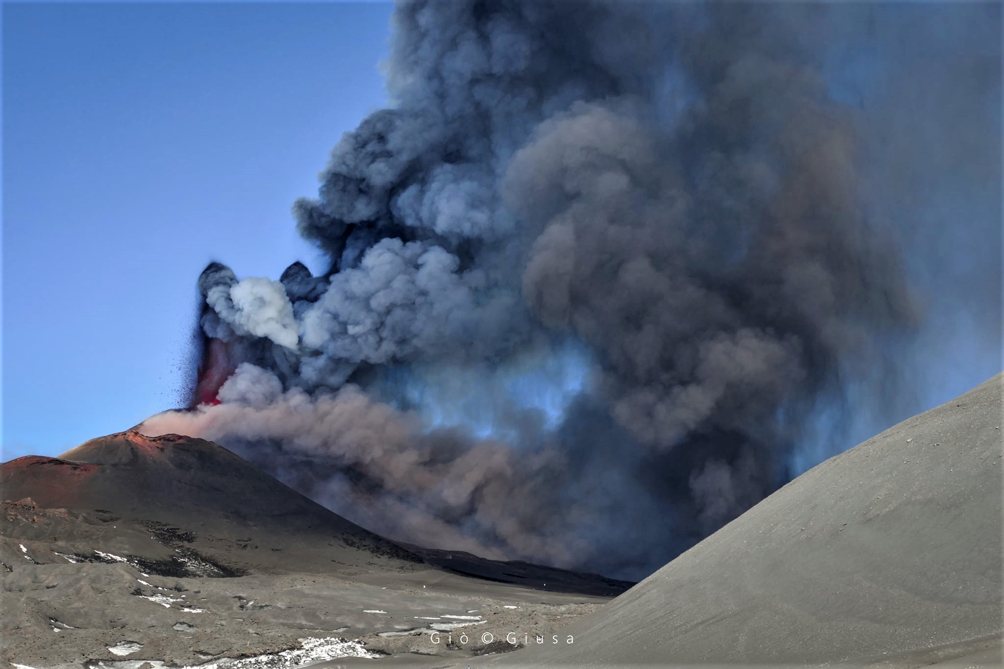
A lava fountain is in progress at the level of the Southeast Crater. The volcanic cloud has reached a height of about 10 km, based on the forecast model, it is heading southeast.
Around 10:40 UTC, a further increase in the average amplitude of the volcanic tremor is observed, which is currently at high levels. The centroid of the sources of volcanic tremors continues to be located in the area of the Southeast Crater at an altitude of approximately 2800-2900 m above sea level. An increase in infrasonic activity is observed which is located near the Bocca Nuova crater.
There are currently no significant changes in the strain signals.
February 21, 2022, 13:15 (12:15 UTC):
From 11:10 GMT, it is possible to observe, from the images of the INGV-OE surveillance cameras, an overflow of lava from the Southeast Crater which is spreading towards the South-West. The volcanic cloud also reached a height of at least 11 km above sea level.
The average amplitude of the volcanic tremor is always at very high levels. The centroid of the sources of volcanic tremors is located in the region of the Southeast Crater at an altitude of about 2900-3000 m above mean sea level. An increase in the frequency of occurrence and the l amplitude of the infrasonic events which are located in correspondence with the Southeast Crater.
Ground deformation monitoring networks show variations on the tilt signals from the summit stations with a maximum of about 2.5 microrads at the Cratere del Piano station.
February 21, 2022, 14:12 (13:12 UTC):
Southeast Crater lava fountaining has ceased. The volcanic cloud produced by the explosive activity has reached an estimated height of about 12,000 m above sea level and is dispersed to the south-southeast. INGV-OE field staff report volcanic ash fallout in Viagrande, Trecastagni and Zafferana. The lava flow produced by ongoing Southeast Crater activity is still being fed.
From around 12:10 UTC, there is a rapid decrease in the average values of the amplitude of the volcanic tremor, which settle on an average level with a tendency to decrease. The center of gravity of the sources of volcanic tremors remains localized in the area of the Southeast Crater at an altitude of approximately 2900-3000 m. Even the infrasonic activity, which continues to be localized in the area of the Southeast Crater, shows a clear decrease in the number of events and their amplitude.
The tilt array showed small variations of a few microradians at the summit stations during lava fountaining activity, with a maximum of about 5.2 microrads measured at the ECP station. On the other hand, no significant variation was observed in the time series of ground deformations from the GNSS network.
February 21, 2022, 15:53 (14:53 UTC):
From the images of the surveillance cameras and the INGV-OE personnel in the field, we observe a weakly fed flow, which extends towards the East and whose lava front remains confined to the summit zone reaching a altitude of about 2900 m. In addition, the flow which propagates in the South-West direction is still fed.
February 21, 2022, 18:21 (17:21 UTC):
Explosive activity at Southeast Crater has ceased. INGV-OE field staff observed fallout of volcanic ash produced during lava fountaining in the towns of Viagrande, Milo and Acicastello, with the main axis of dispersal between Petrulli and Zafferana.
With regard to the effusive activity, the lava flows which propagate in the direction of the South-West and the East are still weakly fed. The average amplitude of the volcanic tremor, from about 14:00 UTC after some fluctuations around the average values, showed a new tendency to decrease, currently settling at medium-low levels. The location of the center of gravity of the sources of volcanic tremors remains located in the area between the Bocca Nuova crater and the Southeast Crater, at an altitude of approximately 2700-2800 meters above sea level Infrasound activity is very low.
Since the end of the paroxysmal episode, no significant change is observed in the inclinometer and GNSS deformation data.
Further updates will be communicated soon.
Source : INGV.
Photos : Guide Alpine Vulcanologiche Etna , Etna Walk / Giuseppe Distefano / Marco Restivo , Gio Giusa .
Peru , Sabancaya :
Analysis period: from February 14, 2022 to February 20, 2022, Arequipa, February 21, 2022.
Alert level: ORANGE
The Geophysical Institute of Peru (IGP) reports that the eruptive activity of the Sabancaya volcano remains at moderate levels, that is to say with the recording of an average of 23 daily explosions, with columns of ash and of gas up to 1.7 km altitude above the summit of the volcano and their subsequent dispersion. Therefore, for the following days, no significant change is expected in eruptive activity.
The IGP recorded and analyzed the occurrence of 155 earthquakes of volcanic origin, associated with the circulation of magmatic fluids inside the Sabancaya volcano. An average of 23 explosions was recorded daily. During this period, Volcano-Tectonic (VT) type earthquakes associated with rock fracturing were located mainly in the northwest and southwest of Sabancaya and presented magnitudes of M 2.3.
Monitoring the deformation of the volcanic structure using GNSS techniques (processed with fast orbits) does not show any significant anomalies. However, in general, an inflation process has been observed in the northern sector (surroundings of the Hualca Hualca volcano). Visual surveillance identified columns of gas and ash up to 1.7 km above the summit of the volcano, which were dispersed to the northwest, west, south and southwest sectors of the volcano. Sabancaya. Satellite recordings have identified the presence of 2 thermal anomalies, with a maximum value of 10 MW, associated with the presence of a lava body on the surface of the crater of the volcano.
RECOMMENDATIONS
• Keep the volcanic alert level orange.
• Do not approach within a radius of less than 12 km from the crater.
Source : CENVUL
Photo : Ingemmet.
Indonesia , Semeru :
VOLCANO OBSERVATORY NOTICE FOR AVIATION – VONA
Issued : February 22 , 2022
Volcano : Semeru (263300)
Current Aviation Colour Code : ORANGE
Previous Aviation Colour Code : orange
Source : Semeru Volcano Observatory
Notice Number : 2022SMR34
Volcano Location : S 08 deg 06 min 29 sec E 112 deg 55 min 12 sec
Area : East java, Indonesia
Summit Elevation : 11763 FT (3676 M)
Volcanic Activity Summary :
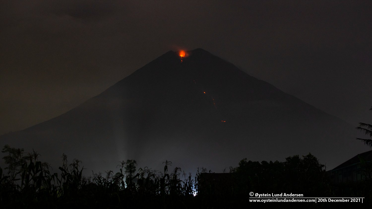
Eruption with volcanic ash cloud at 00h15 UTC (07h15 local)
Volcanic Cloud Height :
Best estimate of ash-cloud top is around 14003 FT (4376 M) above sea level, may be higher than what can be observed clearly. Source of height data: ground observer.
Other Volcanic Cloud Information :
Ash-cloud moving to north
Remarks :
Seismic activity is characterized by eruption, avalanche and gas emission earthquakes
The volcano is clearly visible until it is covered by fog. Smoke from the crater was not observed. The weather is sunny to rainy, the wind is light to the North, South, South-West and West. The air temperature is around 21-28°C. The earthquake of the eruption was recorded, but visually the height of the eruption and the color of the ashes were not observed.
Earthquakes are related to magma, tectonic activity and lahars. It was recorded:
– 74 earthquakes of eruptions/explosions
– 8 emission earthquakes
– 8 harmonic tremors
– 1 distant tectonic earthquake.
Sources : Magma Indonésie , PVMBG.
Photo : Oystein Lund Andersen
Guatemala , Fuego :
Activity:
4 to 7 weak to moderate explosions are generated per hour. These generate gas and ash plumes 4,400 to 4,700 m a.s.l. (14,435 to 15,419 ft) that extend 10 to 15 km to the west and southwest. The explosions are accompanied by avalanches of weak, moderate and strong characteristics, mainly in the direction of the Ceniza ravine, generating materials that reach the edge of the vegetation.

Low to moderate rumblings were recorded, which rattled the roofs and windows of houses around the volcano. Low to moderate sounds similar to those of a train locomotive were heard for periods lasting 1 to 8 min. During the night and early in the morning, an incandescence is observed from 100 to 300 meters above the crater as well as an active lava flow activity of 150 meters in length towards the ravine of Ceniza. The recommendations of special bulletin BEFGO 005-2022 are still valid.
Source : Insivumeh.
Photo : @davidrojasgtfoto.
Saint Vincent , Soufrière Saint Vincent :
La Soufriere Volcano – SCIENTIFIC UPDATE, February 15, 2022, 1:00 p.m.
1. Seismic activity at La Soufriere, St Vincent has continued to be at a low level since shaking associated with the 2021 explosion and ash evacuation. No Lahar signal was recorded.
2. Gas measurements indicate that the plume chemistry shows declining sulfur dioxide (SO2) and carbon dioxide (CO2) concentrations. The plume chemistry indicates that the gas composition is slowly returning to its pre-eruption chemistry.

4. The current activity corresponds to a period of unrest after an eruption. This can continue for weeks to months. As volcanic activity has subsided, secondary hazards like lahars may occur.
5. The volcano is at the YELLOW alert level.


No comment yet, add your voice below!