
January 29 , 2022.
Chile , Callaqui :
Special report on volcanic activity (REAV), Biobío region, Callaqui volcano. January 27, 2022, 1:15 p.m. local time (mainland Chile)
The National Geology and Mining Service of Chile (Sernageomin) publishes the following information obtained through the monitoring equipment of the National Volcanic Monitoring Network (RNVV), processed and analyzed at the Volcanic Observatory of the Southern Andes (Ovdas ):
By following the analysis of surveillance images, obtained from fixed cameras installed on the Callaqui volcano, at 9:55 p.m. HL (00:55 UTC), it was identified the appearance of an incandescence in the southwestern sector of the crater, interpreted as an increase in the temperature of gaseous emissions, present continuously during the night.
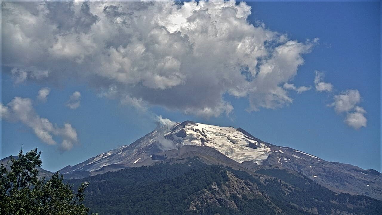
It should be noted that this phenomenon had never been recorded since the surveillance system by fixed cameras on this volcanic system has existed (since 2012).
During the day, a degassing of greater intensity was observed, coinciding with the incandescent zone. The height of this phenomenon reached the height of 380 m, value usually recorded on this volcano.
At the time of this report, visual monitoring continues and any significant changes in activity will be reported immediately.
The volcanic technical alert remains at the GREEN level.
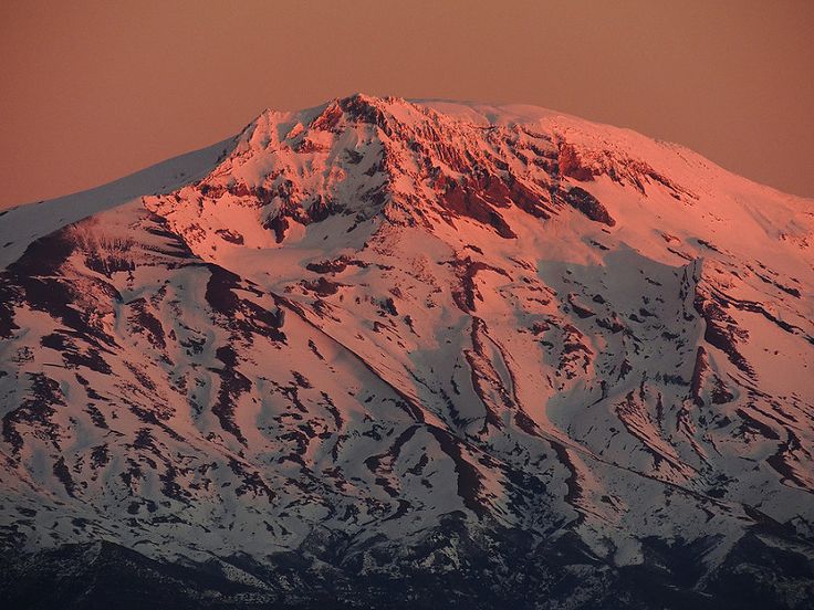
The late-Pleistocene to Holocene Callaqui stratovolcano has a profile of an overturned canoe, due to its construction along an 11-km-long, SW-NE fissure above a 1.2-0.3 million year old Pleistocene edifice. The ice-capped, basaltic-andesite volcano contains well-preserved cones and lava flows, which have traveled up to 14 km. Small craters 100-500 m in diameter are primarily found along a fissure extending down the SW flank. Intense solfataric activity occurs at the southern portion of the summit; in 1966 and 1978, red glow was observed in fumarolic areas (Moreno 1985, pers. comm.). Periods of intense fumarolic activity have dominated; few historical eruptions are known. An explosive eruption was reported in 1751, there were uncertain accounts of eruptions in 1864 and 1937, and a small phreatic ash emission was noted in 1980.
Source : Sernageomin .
Photo : Sernageomin , Susan Teal.
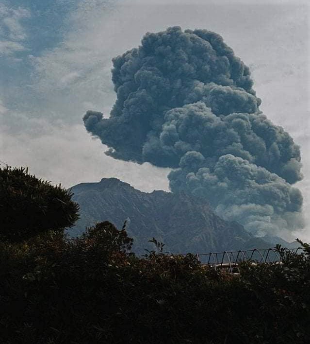
Japan : Sakurajima
On January 28, 2022, the Sakurajima volcano erupted in Kagoshima, Japan. According to the Japan Meteorological Agency, the volcanic ashes will land in several nearby cities. The volcano is located near the city of Kagoshima with a population of around 600,000 people.
JMA reported that incandescence from Minamidake Crater (at Aira Caldera’s Sakurajima volcano) was visible at night during 17-24 January. Sulfur dioxide emissions were somewhat high on 17 January at 1,000 tons per day. Two explosions on 18 January produced ash plumes that rose as high as 2 km above the crater rim and ejected ballistics 1-1.3 km away from the crater. The Alert Level remained at 3 (on a 5-level scale), and residents were warned to stay 2 km away from the crater
The Aira caldera in the northern half of Kagoshima Bay contains the post-caldera Sakurajima volcano, one of Japan’s most active. Eruption of the voluminous Ito pyroclastic flow accompanied formation of the 17 x 23 km caldera about 22,000 years ago. The smaller Wakamiko caldera was formed during the early Holocene in the NE corner of the Aira caldera, along with several post-caldera cones. The construction of Sakurajima began about 13,000 years ago on the southern rim of Aira caldera and built an island that was finally joined to the Osumi Peninsula during the major explosive and effusive eruption of 1914. Activity at the Kitadake summit cone ended about 4850 years ago, after which eruptions took place at Minamidake. Frequent historical eruptions, recorded since the 8th century, have deposited ash on Kagoshima, one of Kyushu’s largest cities, located across Kagoshima Bay only 8 km from the summit. The largest historical eruption took place during 1471-76.
Sources : news.cgtn.com , GVP
Photo : La humanidad perfecta
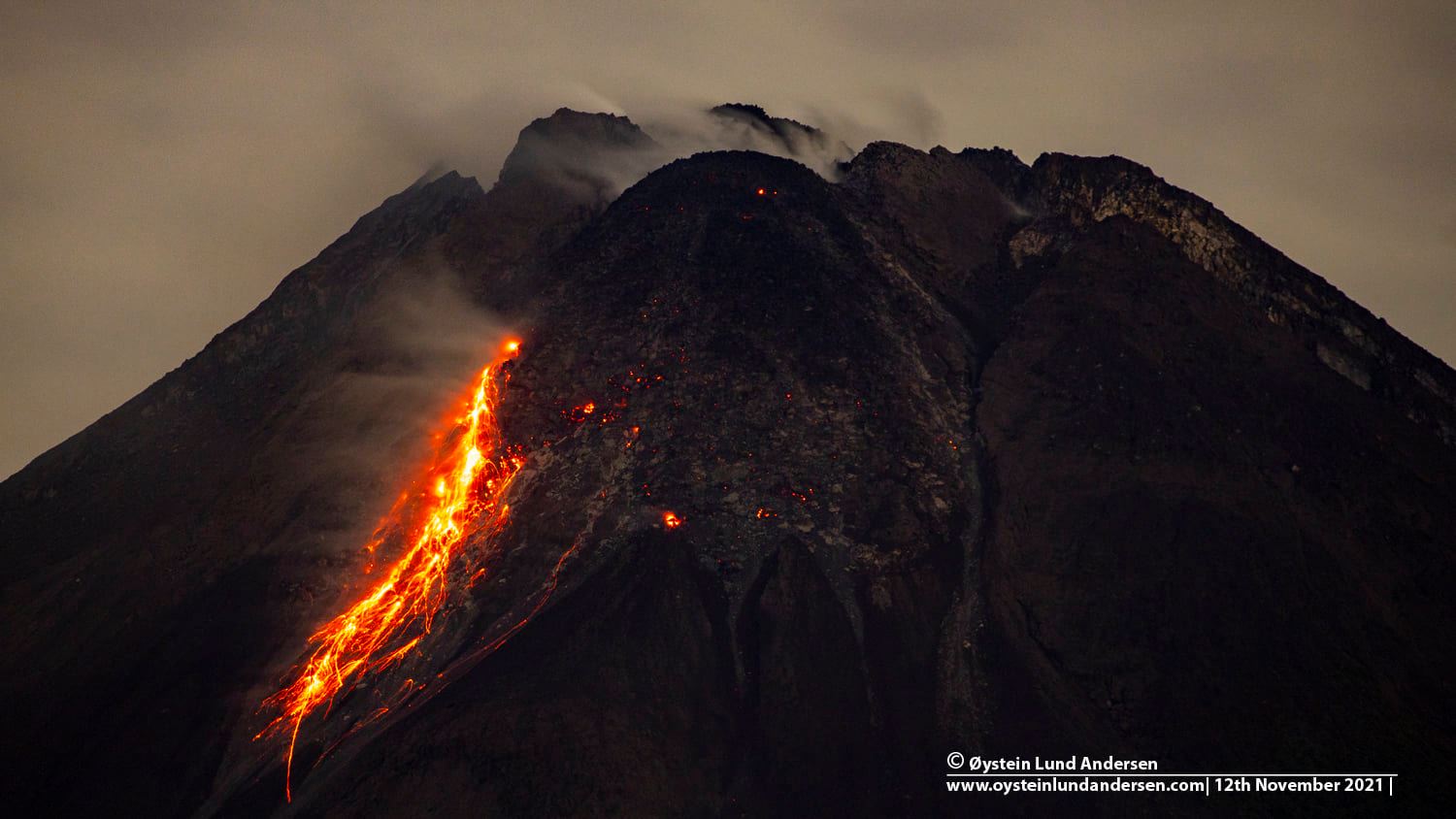
Indonesia , Merapi :
Report on the activity of Mount Merapi, from January 21 to 27, 2022.
– The weather around Mount Merapi is generally sunny in the morning and evening, while foggy in the afternoon.
– This week 2 hot avalanche clouds were observed in the South West, upstream of the Bebeng River with a sliding distance of 2,000 to 2,500 m. Lava avalanches were observed 30 times to the southwest, descending the Bebeng River with a maximum slip distance of 1,800 m.
– Camera morphological analysis showed no significant morphological changes in either the Southwest lava dome or the central dome. The volume of the Southwest lava dome is 1,670,000 m3 and the central dome is 3,007,000 m3.
– The intensity of seismicity this week is still quite high.
Mount Merapi’s deformation, which was monitored using EDM this week, showed a distance shortening rate of 0.2 cm/day.
– Rainfall intensity was 99 mm/hour for 225 minutes at Kaliurang station on January 21, 2022 and it was reported that there was an increase in flow in the Boyong River.
CONCLUSION
1. The volcanic activity of Mount Merapi is still quite high in the form of effusive eruption activity. The state of the activity is defined at the « SIAGA » level.
2. The current potential danger is in the form of lava avalanches and hot clouds in the South-South-West sector covering the Boyong river for a maximum of 5 km, the Bedog, Krasak, Bebeng rivers for a maximum of 7 km. The Southeast sector covers the Woro River for a maximum of 3 km and the Gendol River for a maximum of 5 km. Meanwhile, the ejection of volcanic material in the event of an explosive eruption can reach a radius of 3 km around the summit.
Source : BPPTKG.
Photo : Oystein Lund Andersen
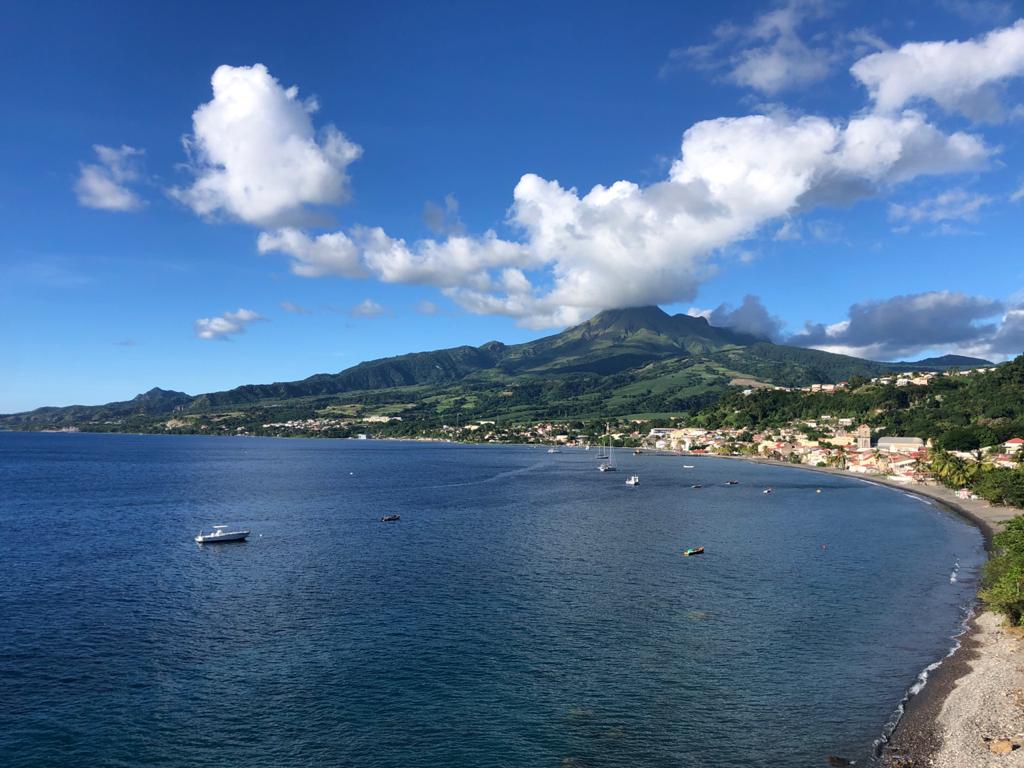
La Martinique , Montagne Pelée :
Weekly report on the activity of Mount Pelée for the period from January 21 to 28, 2022.
Between January 21, 2022 at 4 p.m. (UTC) and January 28, 2022 at 4 p.m. (UTC), the OVSM recorded at least 8 volcano-tectonic earthquakes. These low-energy earthquakes were located within the volcanic edifice about 0.7 km deep below the surface. This superficial volcano-tectonic seismicity is associated with the formation of micro-fractures in the volcanic edifice.
None of these earthquakes were felt by the population.
The zone of degassing at sea at shallow depth between St Pierre and le Prêcheur is still observed. The IGP took fluid samples in order to understand the origin of this degassing and to assess its possible relationship with the Mount Pelée hydrothermal system.
Vegetation is regrowing at the level of the main zone of degraded vegetation which is observed on the southwestern flank of Mount Pelée, between the upper Claire river and the Chaude river. However, new areas of deteriorated and dead vegetation have been detected by analysis of satellite images in the upper Claire River and near the Hot Springs.
The alert level remains YELLOW: vigilance.
Source : Direction de l’OVSM IPGP.
Photo : rci.fm
Hawaii , Mauna Loa :
19°28’30 » N 155°36’29 » W,
Summit Elevation 13681 ft (4170 m)
Current Volcano Alert Level: ADVISORY
Current Aviation Color Code: YELLOW
Activity Summary:
Mauna Loa volcano is not erupting. Rates of seismicity remain slightly elevated above long-term background levels, but have not changed significantly over the past week. Other Mauna Loa monitoring data streams—ground deformation, gas concentrations, visual appearance in webcams—show no significant changes.
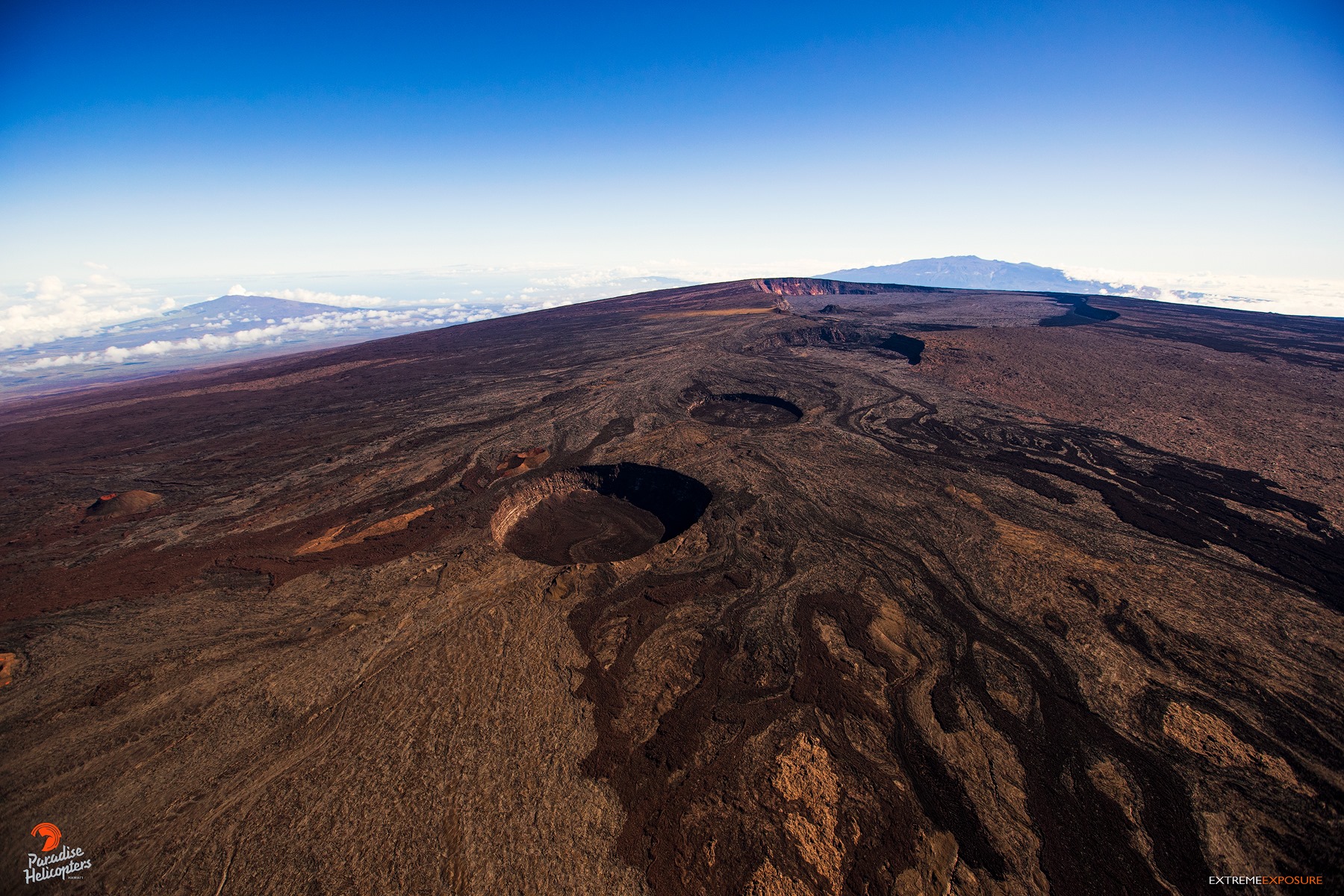
Observations:
During the past week, HVO seismometers recorded approximately 77 small-magnitude (below M2.5) earthquakes below the summit and upper-elevation flanks of Mauna Loa. The majority of these earthquakes occurred at shallow depths less than 10 kilometers (6 miles) below sea level.
Global Positioning System (GPS) measurements show very low rates of deformation in the summit region continuing through the past week.
Gas concentrations and fumarole temperatures at the summit and at Sulphur Cone on the Southwest Rift Zone remain stable.
Webcam views have shown no changes to the volcanic landscape on Mauna Loa over the past week.
Source : GVP.
Photo : Bruce Omori / Paradise helicopters


No comment yet, add your voice below!