
December 29 , 2021.
La Réunion Island , Piton de la Fournaise :
Press release of December 29, 2021 – 11:30 a.m.
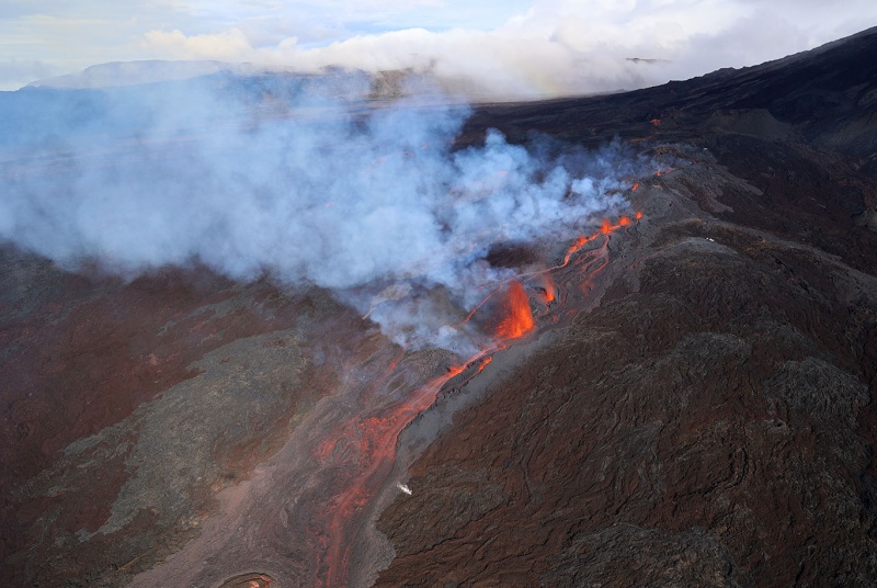
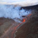
The eruption that began on December 22, 2021 at around 3:30 a.m. local time continues. Over the last 24 hours the amplitude of the eruptive tremor (indicator of an emission of lava on the surface) shows fluctuations. The fluctuations observed can be linked either to:
– the cone under construction which undergoes construction and dismantling phases, thus influencing the speed of the lava flows at the level of the vent;
– or to punctual releases of pockets of gas trapped in the supply ducts which can be released suddenly leading to an increase in the tremor.
The average amplitude of the tremor is this morning at about 50% of its initial amplitude
The bad weather conditions on the eruptive site present since yesterday at the end of the afternoon, no longer allow visual feedback with the eruption. Thus no information relating to the fountains and lava flows as well as to the construction of the cone around the vent can be given this morning. However, the last observation, made yesterday at 6.30 p.m. local time, shows weak lava fountains as well as the appearance of a small mouth (opening in a lava tunnel) located at the foot of the cone on the downstream side.
Over the last 24 hours:
– Two volcano-tectonic earthquakes under the summit were recorded.
– Surface deformations no longer show significant deformation.
– No estimate of lava flow could be established by satellite method with the HOTVOLC platform (OPGC – Clermont Auvergne University), following the cloud cover present since yesterday afternoon.
– The position of the flow front could not be observed for the same reason.
Alert level: Alert 2-1 (eruption in the Enclos )
Source: OVPF / IPGP.
Photo: IP Réunion.
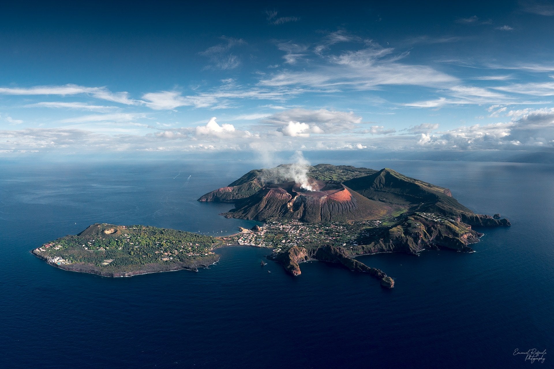
Italy , Vulcano :
WEEKLY NEWSLETTER from December 20, 2021 to December 26, 2021 (issue date December 28, 2021)
SUMMARY OF THE STATUS OF THE ACTIVITY.
In view of the monitoring data, it is highlighted:
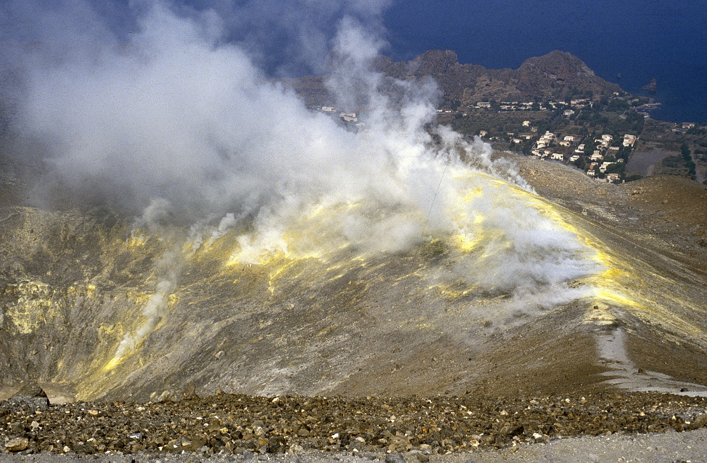
1) Temperature of the fumaroles of the crater: The temperature values continue to show a decreasing trend on the edge of the crater while they remain stable on the internal face.
2) Flux of CO2 in the crater area: The values of CO2 flux on the ground in the summit area (VCS) show a downward trend, while remaining high.
3) SO2 flux in the crater area: SO2 flux at a high level
4) Geochemistry of fumarolic gases: There is no update. The next sample is scheduled for mid-January.
5) Flux of CO2 at the base of the La Fossa cone and in the area of Vulcano Porto: The flux values at the base of the cone show stable or slightly increasing trends, settling in any case on high values, at with the exception of the Faraglione site, where low values are recorded, typical of the background level that characterizes this site.
6) Geochemistry of thermal aquifers: The physicochemical parameters are stable on the Sicilia and Bambara Camping sites.
7) Local seismicity: The rate of occurrence of low frequency events (VLP) is markedly reduced.
8) Regional seismicity: No earthquake with Ml> = 1.0 was located, in the week in question, in the area of the island of Vulcano.
9) Deformations – GNSS: The GNSS network does not show any variations during the period studied.
10) Deformations – Inclinometry: The inclinometric network shows a tendency to return to the deformations observed in recent months.
11) Other observations: GB-RAR: The results of the GB-RAR monitoring referring to the period from December 14 to 27, show a general stability of the area, with deformations along the LOS of less than 1 mm.
Gravimetry: Fast and localized gravity variations are recorded at the VSOCR continuous station. There are no changes attributable to significant phenomena of deep mass redistribution.
Temperature of the fumaroles of the crater:
From November 24, the fumaroles on the edge show a negative trend. The rains last week caused further disruption and the loss of some data. Few of the temperature readings recorded exceeded 300 ° C. The temperatures monitored on the internal side show a relative stability, and the maximum values do not exceed 110 ° C.
SO2 flux in the crater area:
The flux of CO2 on the ground in the summit area (VCS) shows high values around 9000 g / m2 / day, remaining in an order of magnitude above the averages recorded over the last 10 years. A gradual decrease in degassing is observed on a monthly scale.
CO2 flux at the base of the La Fossa cone and in the Vulcano Porto area:
The CO2 fluxes from the soil (acquired automatically by the VULCANOGAS network) at the Rimessa and Camping Sicilia sites show slight increases compared to last week and the values remain high. On the Palizzi site (P4max) new growth is observed with values still much higher than background noise. The Faraglione site has maintained an almost stable trend since last week and values are at the typical bottom level for this site.
Source : INGV.
Photos : Emanuel Raffaele Photography , Boris Behncke
Iceland , Reykjanes Peninsula :
Since midnight around 90 earthquakes have been detected. Yesterday around 1300 earthquakes had been detected on the Reykjanes peninsula as a whole. This is a lot less than the day before when around 2300 earthquakes were detected.
Yesterday at 14:29 an earthquake M3.9 was measured by Hofmannaflöt, just E of lake Djúpavatn. It was felt in the capital region and east towards the town of Hella.
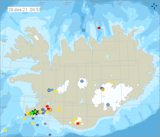
Earlier at 06:25 a eathquake of M3,4 was mesured in the same region but further south.
These earthquakes are interpreted as triggered earthquakes due to increased pressure caused by a dike intrusion near Fagradalsfjall.
Note, that the triggered earthquakes can set loose rocks and small landslides. Travelers are therefore urged to show caution in steep hillsides.
Source et graphique : Vedur is
Italy / Sicily , Etna :
WEEKLY NEWSLETTER from December 20, 2021 to December 26, 2021 (issue date December 28, 2021)
SUMMARY OF THE STATUS OF THE ACTIVITY.
In view of the monitoring data, it is highlighted:
1) VOLCANOLOGICAL OBSERVATIONS: Degassing activity at variable rate of all the summit craters. Weak and discontinuous emissions of very dilute ash from the Bocca Nuova crater and the Northeast Crater.
2) SEISMOLOGY: Modest fracturing seismic activity; the amplitude of the volcanic tremor remained mainly at medium-low levels.
3) INFRASOUND: Moderate infrasound activity.
4) SOIL DEFORMATION: During the last week, the soil deformation monitoring networks have not recorded any significant changes.
5) GEOCHEMISTRY: The flow of SO2 appears at a medium-low level
The CO2 fluxes from the soil recorded by the Etnagas Network are average.
The partial pressure of dissolved CO2 shows values consistent with the seasonal trend.
The isotope ratio of helium arises on medium-high values (the latest data dated 12/16/2021).
There are no updates for the C / S report.
6) SATELLITE OBSERVATIONS: The thermal activity in the summit area was at a low level after the effusive activity of December 13-14, 2021.

Emissions of dilute reddish ash clouds from (a) Bocca Nuova (BN) and (b) Northeast (NEC) craters during INGV staff observations on the morning of December 24
VOLCANOLOGICAL OBSERVATIONS
During the week, the monitoring of the volcanic activity of Mount Etna was carried out through the analysis of the images of the network of surveillance cameras of the INGV, Osservatorio Etneo (INGV-OE) and through the observations made by INGV staff.
The alternating weather conditions, for most of the week, made the observation of volcanic activity discontinuous according to the network of cameras. In general, the period was characterized by variable rate degassing activities of all summit craters, with the exception of the Bocca Nuova (BN) and Northeast (NEC) craters which produced ash emissions. discontinuous and weak.

In particular, after the modest effusive activity in the Valle del Bove and the brief episode of Strombolian activity of the Southeast crater last week, the activity of the summit craters was characterized by a variable degassing regime of all the craters. , mainly carried by the collapse crater located in the North-West sector of Bocca Nuova (BN-1), and to a lesser extent by the North-East Crater. Both craters produced light, discontinuous emissions of dilute reddish ash, rapidly dispersed into the atmosphere in the summit area.
The Voragine craters (VOR) and the Southeast crater (SEC), on the other hand, showed degassing mainly linked to the fumarolic systems present along their respective edges.
VOLCANIC TREMOR
The temporal trend of the mean amplitude of the volcanic tremor remained mainly at a medium-low level, throughout the week. The location of the source of the tremor is near the Northeast Crater, at a depth of approximately 0-2500 meters above mean sea level
Source : INGV.
Photos : INGV , Gio Giusa .
Costa Rica , Turrialba :
Daily report of the state of volcanoes. Date: December 28, 2021. Update at: 11:11:00.
At 11:05:00 local time on December 28, 2021, an eruption was recorded on the Turrialba volcano, with a column that rose 50 meters above the height of the crater and 3390 m above sea level. (11,119.2 feet).
Duration of activity: 1 minute.
Seismic activity is similar, compared to yesterday.
At the time of this report, the winds are blowing from the northwest.
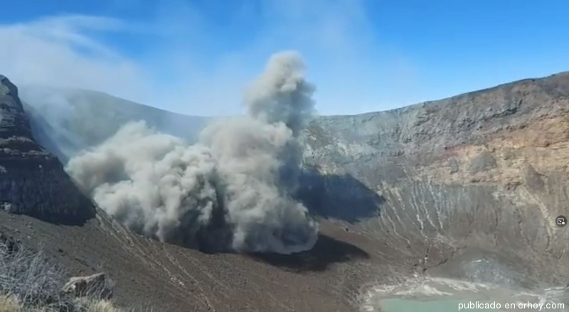
Today, December 28, 2021, there were 2 small eruptions with ash and « rumblings », all of them detected by the seismographs and the infrasound system: The first at 6:44 am and the second at 11:05 am. This latest eruption was observed and heard directly by those responsible for safeguarding the Turrialba Volcano National Park. Seismicity remains dominated by frequent volcanic earthquakes of low frequency type LP type linked to the movement of fluids (water, water vapor and gas). The gases emitted by the volcano show a tendency to decrease their content of sulfur gases such as SO2 and H2S with CO2 / SO2 ratios fluctuating between 20 and 14 and H2S / SO2 between 0.2 and 0.3. The SO2 concentration remains relatively low between 2 and 6 ppm. On the northwest inner wall of the west crater, an incandescent zone is always observed on fog-free nights, indicating fumarole temperatures of at least 300 degrees Celsius. No significant deformation of the volcanic building is observed. The SO2 gas and aerosol analyzers in the ambient air in Coronado show during the last 24 hours notably low concentrations and therefore good air quality: SO2 with an hourly average below the instrumental detection limit of 0.5 ppb and well below the maximum allowed hourly reference value of 75 ppb while PM10 recorded a daily average of 6.0 ug / m3 which is well below the daily average of the regulation on the quality of air of 100 ug / m3.
Source : Ovsicori.
Photo : Diego Nunez Salmeron et Reina Sanchez Solano / crhoy.com .
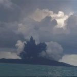
Vanuatu Archipelago , Ambae :
VOLCANO ALERT BULLETIN – AMBAE ACTIVITY Monday December 27th 2021
15°24’0”S 167°50’0”E
Summit 4908ft (1496m)
Current Alert Level: Level 2
The Volcanic activity on Ambae Island has now increased from the minor unrest level to the major unrest level. The Volcanic Alert Level increased from Level 1 to Level 2.
The volcanic activity on Ambae has increased to the Level of major unrest, consistent with the Volcanic Alert Level 2. Since 5th of December 2021, the volcano activity consists of emission of steam and explosions of wet tephra ejected above the lake surface. New analyses suggest that the Ambae volcano activity has significantly increased. Volcanic hazards remain at the summit area and creeks (e.g., remobilization of remaining ash from 2017 and 2018 eruption).
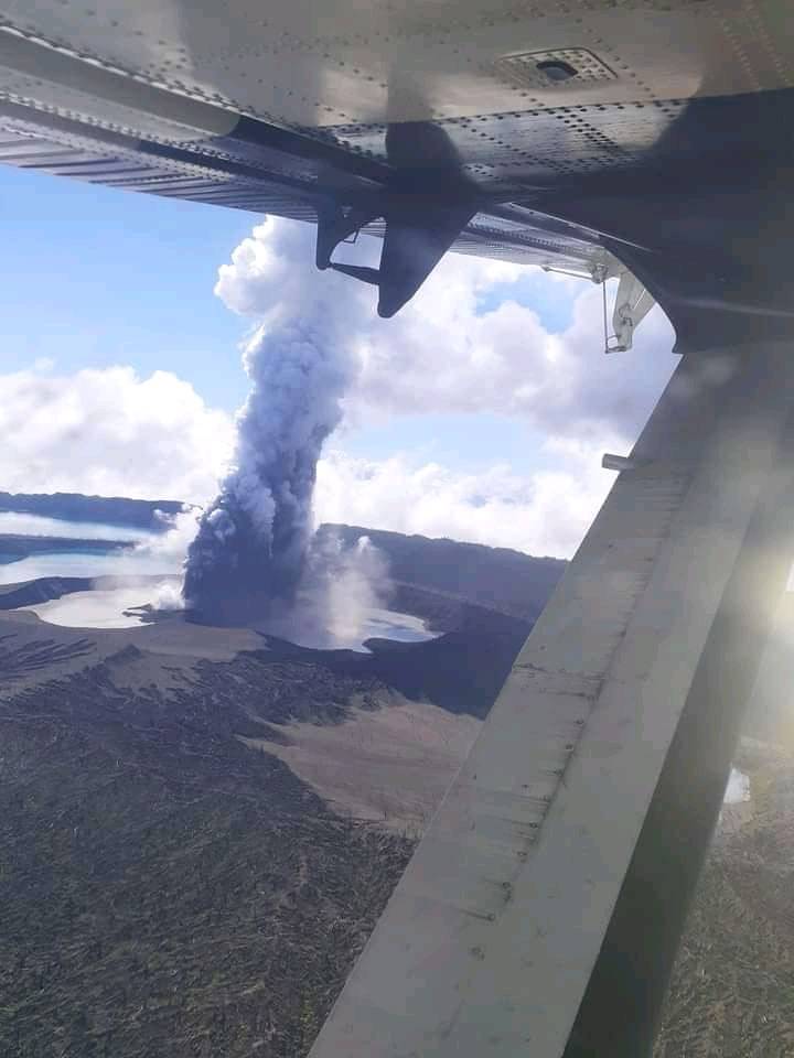
The danger zone for life safety at the summit area remains limited in the Danger Zone . This danger is about 2 km radius from the 2017-2018 active vents. An additional danger zone is within areas of flowing creeks during heavy rain.
New observations confirmed that the volcanic cone has built up inside Lake Voui and Ambae volcano continues to emit volcanic gas and ash contained within Lake Vui, consistent with the activity of the Ambae volcano under Volcanic Alert Level 2 indicating ‘Major level of unrest; the Danger area remains at 2 km around the volcanic vents and within the area of flowing creeks. With this current volcanic activity, it is a useful reminder that eruptions can occur at any level of unrest with little or no warnings.
Source : Geohazard .
Photo : Johnston Aga


No comment yet, add your voice below!