
December 18 , 2021 .
Guatemala , Santiaguito :
SPECIAL VOLCANOLOGICAL BULLETIN. INCREASE IN ACTIVITY.
The Santa María-Santiaguito volcanic complex is in a period of high extrusive activity which in recent months has built a lava dome in the crater of Dome Caliente and a blocky lava flow on the western flank of it. This activity produced weak and moderate avalanches on a frequent basis, as well as explosions and avalanches of moderate to strong characteristics on an occasional basis. Since December 11, the seismic stations STG8, STG3 and STG2 have recorded a greater number of volcano-tectonic earthquakes in the area of the domes of Santiaguito. This increase in seismic activity, which has not been reported to be felt by residents of neighboring communities, has also been accompanied by an increase in the surface activity of the Caliente Dome.
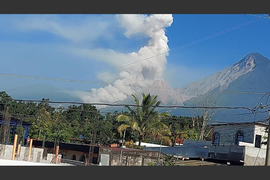
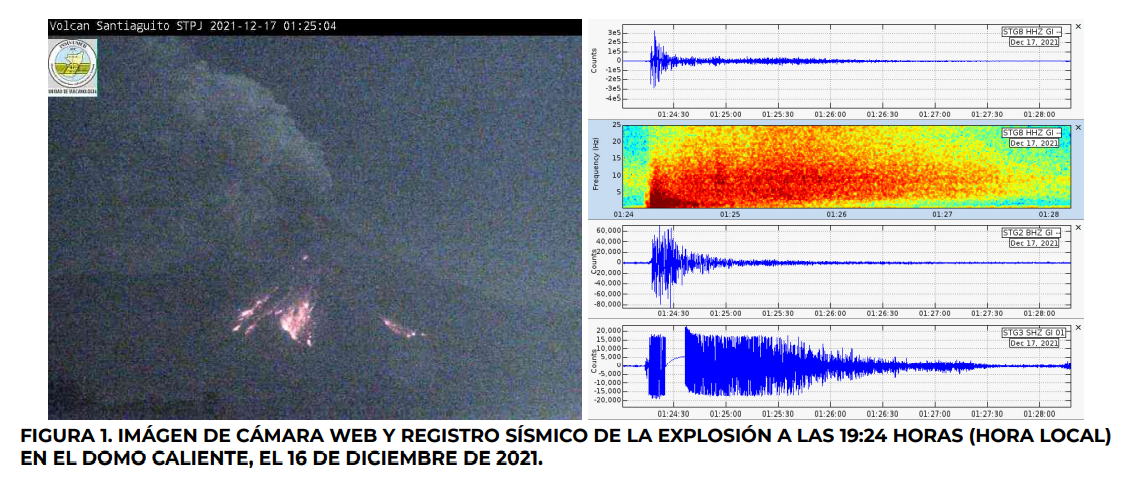
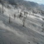
As of December 16, an increase in lava extrusion was observed in the West-South-West rim of the Caliente Dome crater, causing an intense incandescence in the dome, abundant degassing accompanied by sounds similar to a turbine of plane, and the descent of numerous avalanches with moderate to strong characteristics on the western, southern and eastern flanks. In recent hours, moderate to strong explosions with ash columns (Figure 1) were recorded, the ash of which dispersed westward, reaching heights of up to 4,500 meters (14,763 feet) and a dispersal distance of up to 30 kilometers.
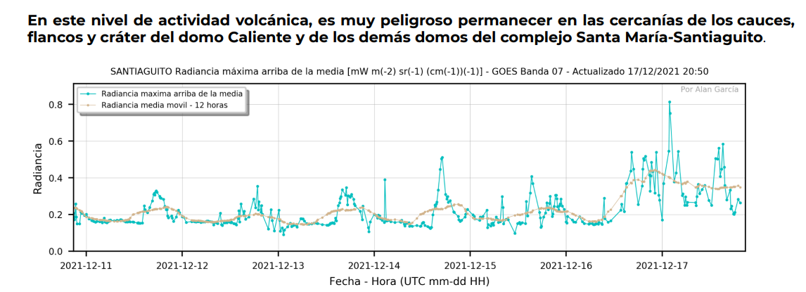
The increase in this activity is also reflected in parameters measured using satellite data, such as luminance or thermal energy (Figure 2). This activity can continue to generate explosions and avalanches of moderate to strong characteristics, therefore, these generate collapses of the material accumulated in the dome of the crater and in the lava flow of the western flank, which would lead to the descent. pyroclastic flows on the sides of the dome, in particular in a south-west, south and / or south-east direction. Additionally, all of this activity can produce abundant ash, which can cover the domed complex, limit visibility, and fall back onto communities and farms near the domes.
INSIVUMEH maintains instrumental and visual monitoring of volcanic activity in the Santa María-Santiaguito complex through its seismic stations, web cameras and OVSAN observers.
It is recommended to maintain precautions with air traffic in the area of the Fuego and Santiaguito volcanoes, due to the presence of ash on the western, south-eastern flanks at a distance of 30 km. The wind speed is likely to increase and move the ash further. It is recommended that you pay attention to ash scatter maps and special bulletins.
Source : Insivumeh .
Photos : Soy502 , Insivumeh.
Chile , Planchon Peteroa :
Special Report on Volcanic Activity (REAV), Del Maule Region, Planchon Peteroa Volcanic Complex, December 16, 2021, 5:45 p.m. local time (Continental Chile).
The National Service of Geology and Mines of Chile (Sernageomin) publishes the following PRELIMINARY information, obtained thanks to the monitoring equipment of the National Volcanic Monitoring Network (RNVV), processed and analyzed at the Volcanological Observatory of the Southern Andes ( Ovdas):
On Thursday, December 16, 2021, at 5:20 p.m. local time (8:20 p.m. UTC), the monitoring stations installed near the Planchon Peteroa volcanic complex recorded an earthquake associated with the fracturing of rocks (volcano-tectonic type VT) in the volcanic system.

The characteristics of earthquakes after their analysis are as follows:
TIME OF ORIGIN: 5:20 p.m. local time (20:20 UTC)
LATITUDE: 35.180 ° S
LONGITUDE: 70.575 ° W
DEPTH: 6.1 km
LOCAL MAGNITUDE: 3.0 (Ml)
OBSERVATIONS:
No superficial activity was observed following the occurrence of this event.
The volcanic technical alert remains at Green level.
Source et photo : Sernageomin
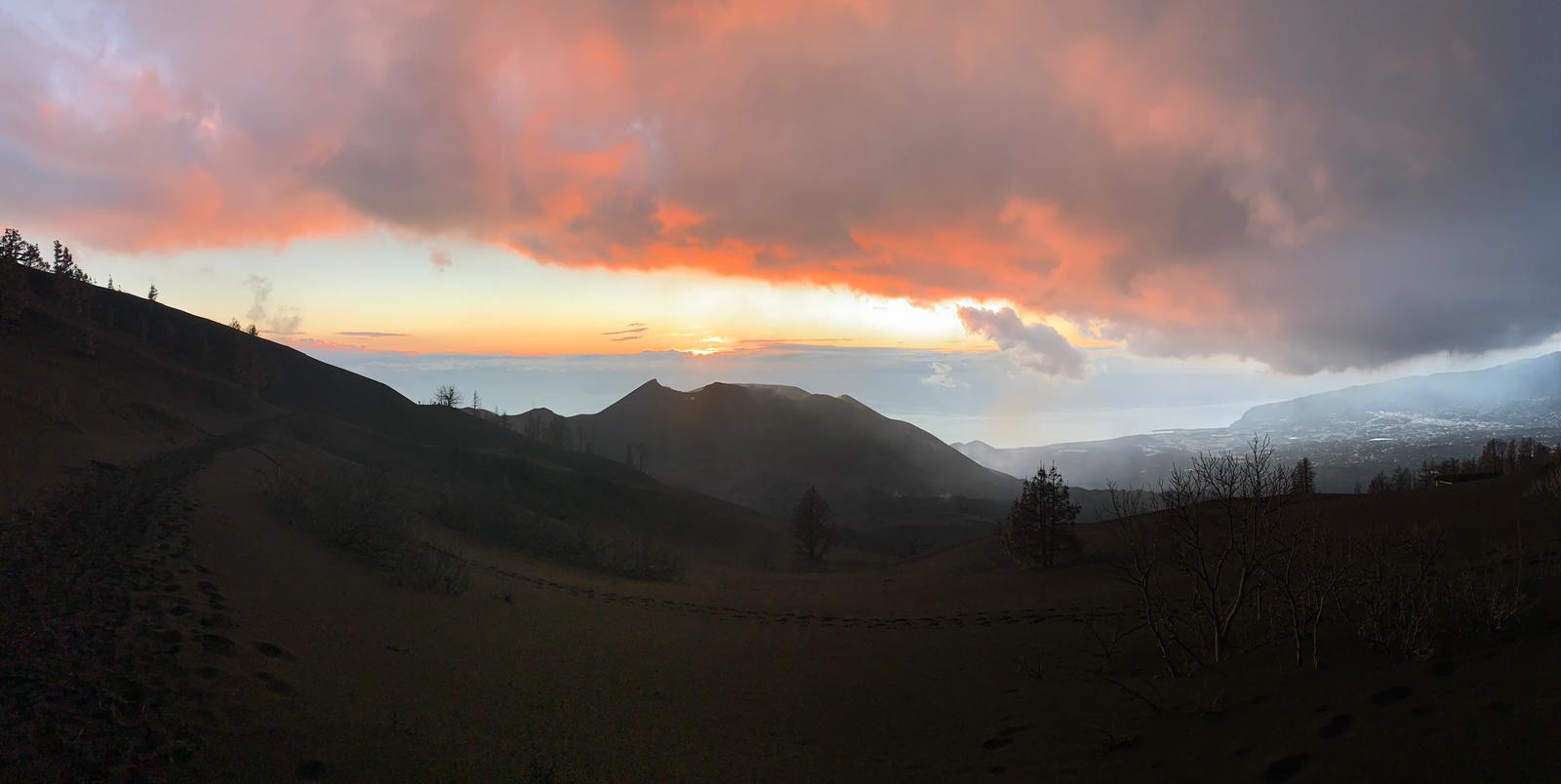
Spain / La Palma , Cumbre Vieja :
December 17, 2021 09:00 UTC. Eruptive activity continues on La Palma.
Since the last declaration, a total of 96 earthquakes have been located on the island of La Palma, two of which were felt by the population.
The maximum recorded magnitude is 3.5 (mbLg), corresponding to yesterday’s earthquake at 22:29 UTC, at a depth of 36 km. The minimum magnitude of the localized earthquake was 1.1 mbLg.
Localized seismicity continues below the central area of Cumbre Vieja in the same areas as the previous days. The earthquakes are mainly divided into two groups, 46 earthquakes are between 8 and 16km deep and 47 earthquakes at depths greater than 30km. Likewise, 3 shallow earthquakes were located in the area, with a depth of less than 3 km.
During the past 24 hours, no volcanic tremor has been observed in the records, keeping the seismic noise at levels close to the pre-eruptive period.
Since the cessation of the volcanic tremor signal on December 13 at 10:20 p.m., events of the low frequency (LP) type have continued to be detected in addition to localized volcano-tectonic earthquakes.
The island’s network of permanent GNSS stations does not show significant deformations that could be associated with volcanic activity.
In view of the image calibrated at 08:45 UTC, no type of emission is visible.
The height of the cone is measured by obtaining a value of 1122 m at sea level.

The tremor signal disappeared at 9:00 p.m. Monday morning, when data collected by the island’s seismic networks dropped to levels that scientists already consider « background noise » after nearly three months of eruption on Cumbre Vieja.
The RSAM signal (amplitude of the tremor measured in a seismic station near the eruption) published by the IGN’s volcanic monitoring service on its website, followed at 7:30 am this Friday in the same values as those it has presented Tuesday morning.
This morning, the island’s seismic network detected 23 small earthquakes, 19 of which were less than magnitude 2, and the other four with values between 2.1 and 2.4. None were felt.
Some of these earthquakes were concentrated at relatively great depths, between 41 and 36 kilometers below the surface, and the rest at medium levels, between 7 and 16 kilometers.
In order to say that the eruptive process is complete, the recorded data and visible signs must be maintained at current levels for an additional eight days.
The emission of volcanic gases is punctual and sporadic, concentrating in the zone of the eruptive centers and in the ruptures of the volcanic tubes.
Weather conditions are not a problem for the operation of La Palma airport.
Air quality is good in all municipalities on the island except Los Llanos de Aridane, which is unfavorable.
Sources : IGNes , El Pais .
Photos : I love the world , IGN.
Indonesia , Merapi :
Merapi activity report from December 10 to 16, 2021.
– The weather around Mount Merapi is generally sunny in the morning and evening, while it is foggy in the afternoon.
– This week 3 hot avalanche clouds were observed upstream of the Bebeng River with a maximum sliding distance of 2000 m. Lava avalanches were observed 116 times southwest, descending into the Bebeng River with a maximum slide distance of 2,000 m.
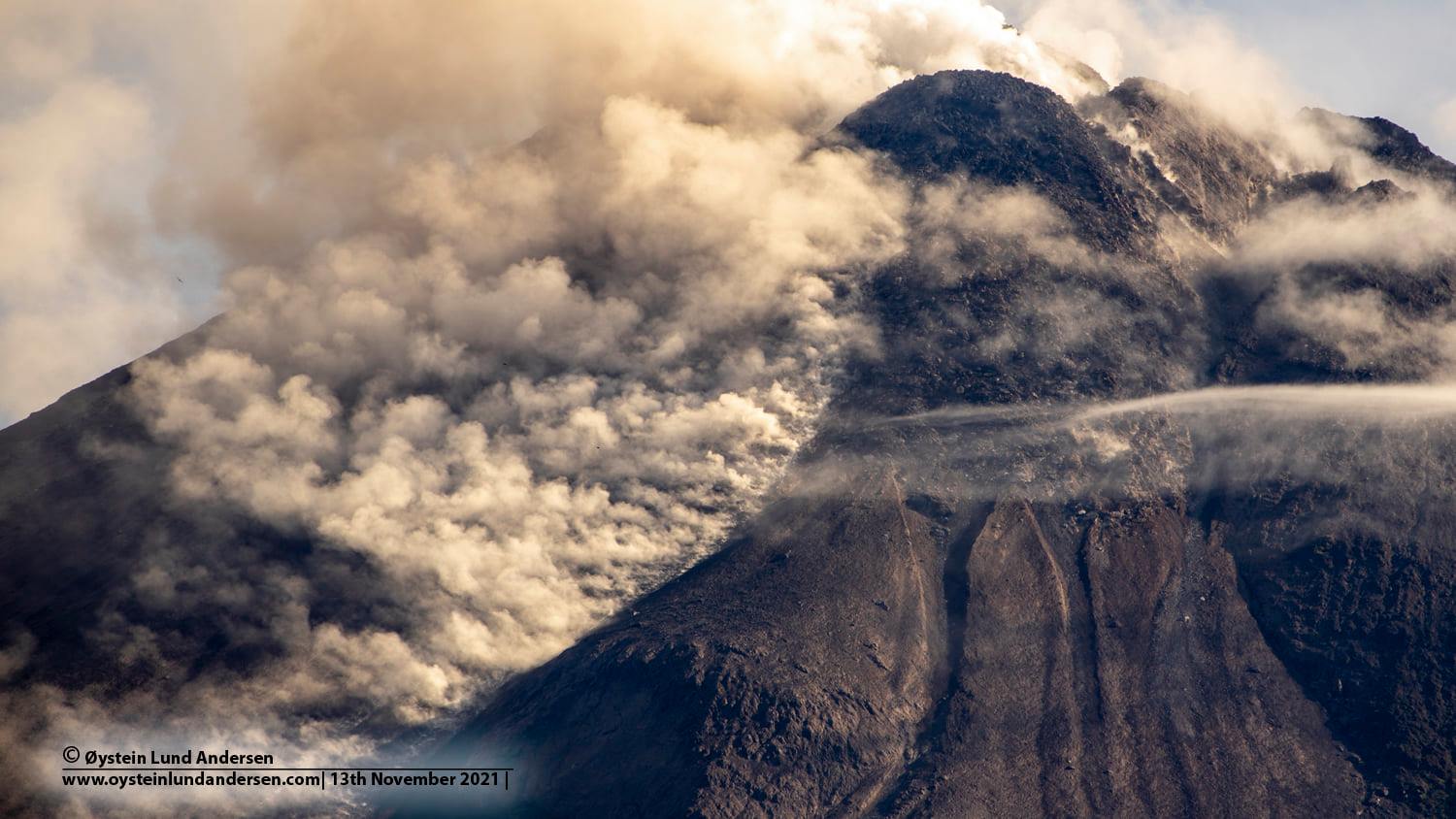
– No significant morphological change was observed either in the southwest dome or in the central dome. The volume of the southwest lava dome is 1,622,000 m3 and the central dome is 3,007,000 m3.
– The intensity of the seismicity this week is higher than last week. The deformation of Mount Merapi, which was monitored using EDM this week, showed a distance shortening rate of 0.4 cm / day.
– The rainfall intensity was 77mm / hour for 180 minutes at Kaliurang Station on December 16, 2021. There have been no reports of lahars or additional flow in the rivers that originate on Mount Merapi.
Volcanic earthquakes are linked to magma activity as well as tectonic activity. It was recorded:
– 1 earthquake of hot avalanche clouds
– 205 avalanche earthquakes
– 5 earthquakes of emissions
– 5 multi-phase earthquakes
– 1 shallow volcanic earthquake
– 1 distant tectonic earthquake.

Conclusion:
– The volcanic activity of Mount Merapi is still quite high in the form of effusive eruption activity. The status of the activity is defined in the “SIAGA” level.
– The current potential danger consists of lava avalanches and hot clouds in the South-East / South-West sector over a maximum of 3 km to the Woro river and 5 km to the Gendol and Kuning rivers , Boyong, Bedog, Krasak, Bebeng and Putih. During this time, the ejection of volcanic material in the event of an explosive eruption can reach a radius of 3 km from the summit.
Source : BPPTKG.
Photos : Oystein Lund Andersen.
Alaska , Pavlof :
55°25’2″ N 161°53’37 » W,
Summit Elevation 8261 ft (2518 m)
Current Volcano Alert Level: WATCH
Current Aviation Color Code: ORANGE
Eruptive activity at Pavlof Volcano continues. Elevated seismicity, consisting of periods of sustained tremor and discrete low-frequency events, was detected throughout the past week. Small explosions were detected in seismic and infrasound data on three days this week, producing weak ash emissions that deposited ash locally to the northeast of the active vent. During periods of clear weather, satellite views showed lava effusion on the east flank of the volcano, which generated a small lahar from meltwater.
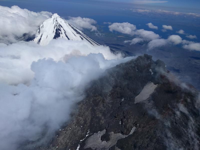
Pavlof Volcano, foreground, and Pavlof Sister, background.
Periods of lava fountaining from the vent on the volcano’s upper southeast flank have been occurring since mid-November. This activity has built a small cone and sent flows down the flank that melt the snow and ice and can produce variable amounts of meltwater. The meltwater typically incorporates loose debris on the flank of the volcano and forms lahars. The lahar deposits observed so far appear relatively thin (<2 m thick) and were likely emplaced by water-rich flows. The lahar deposits extend down the east-southeast flank for several kilometers, not quite to the base of the volcano.
Previous eruptions of Pavlof indicate that the level of unrest can change quickly and the progression to more significant eruptive activity can occur with little or no warning.
Pavlof is monitored by local seismic and infrasound sensors, satellite data, web cameras, and remote infrasound and lightning networks.
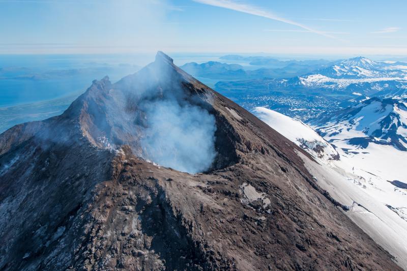
Pavlof Volcano is a snow- and ice-covered stratovolcano located on the southwestern end of the Alaska Peninsula about 953 km (592 mi) southwest of Anchorage. The volcano is about 7 km (4.4 mi) in diameter and has active vents on the north and east sides close to the summit. With over 40 historic eruptions, it is one of the most consistently active volcanoes in the Aleutian arc. Eruptive activity is generally characterized by sporadic Strombolian lava fountaining continuing for a several-month period. Ash plumes as high as 49,000 ft above sea level have been generated by past eruptions of Pavlof, and during the March 2016 eruption, ash plumes as high as 40,000 ft above sea level were generated and the ash was tracked in satellite data as distant as eastern Canada. The nearest community, King Cove, is located 48 km (30 miles) to the southwest of Pavlof.
Source : AVO.
Photos : Izbekov, Pavel / Alaska Volcano Observatory / University of Alaska Fairbanks, Geophysical Institute , Waythomas, Chris Alaska Volcano Observatory / U.S. Geological Survey( 2017).


No comment yet, add your voice below!