
November 14 , 2021.
Spain / La Palma , Cumbre Vieja :
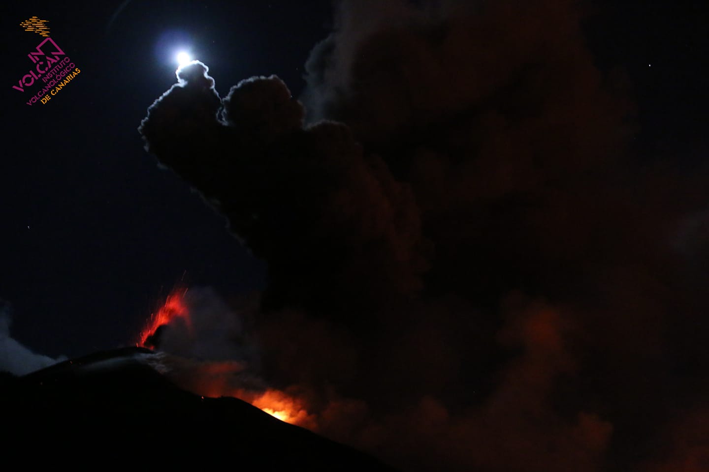
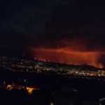
November 13, 2021, 10:00 UTC. Eruptive activity continues on La Palma.
Since the last declaration, 31 earthquakes have been located in the area affected by the volcanic reactivation of Cumbre Vieja, most of which have been located at depths greater than 30 km.
Only one of the earthquakes was felt by the population during this period. This is the largest earthquake, recorded at 06:56 (UTC) today with a magnitude of 5.0 mbLg and which reached a maximum intensity of IV-V (EMS98) in the epicentral zone.
The tremor signal continues at low values.
As yesterday, the network of permanent GNSS stations on the island shows that after reversing the inflation on days 4 and 5 in station LP03, which is closest to the eruptive centers, it remains at a lower level than previously established ; however, the station continues to record a southerly deformation.
In the rest of the stations, the slight deflation possibly linked to the deep seismicity has moderated.
Based on the calibrated image, a column height of 3,100 m is estimated at 08:45 UTC with a southwest direction. The height of the cone is measured by obtaining a value of 1130 m at sea level.
A 72-year-old man died in La Palma while removing ashes from the roof of his house. This is the first death since the volcano erupted. The body was found on Saturday, after the day before it had been part of a cleanup operation in the exclusion zone, as reported by sources close to the Canary Islands Volcanic Emergency Plan (Pevolca) . The Civil Guard is investigating whether his death was due to a fall from the roof while cleaning the ashes or other circumstances.
Good or reasonably good air quality levels are maintained in all municipalities, although the threshold was exceeded at some point in Puntagorda.
With the level of seismicity recorded, it is still likely that earthquakes of intensity V-VI will occur which could cause landslides in sloping areas. It is expected that the thresholds will be exceeded and that there will be earthquakes of greater magnitude and at shallower depth, of greater intensity.
Precipitation is likely to occur in the north and east of the island and also in the west, but not in the vicinity of the cone.
The height of the eruptive column of ash cloud and sulfur dioxide is 3,100 meters.
The next 36-48 hours will continue with a favorable scenario for airport operations.
Sulfur dioxide emissions continue to be high, registering values of 14,000 and 20,000 tonnes per day.
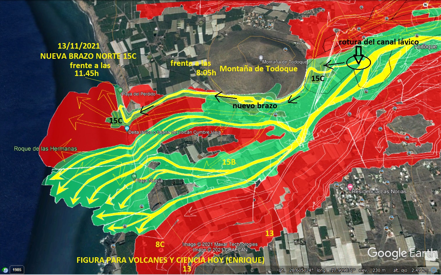
All the flows are stable except the 1, 2 and 9, which are those which have the highest contribution in magma and which feed the new delta which was created on the beach of Los Guirres.

More than two dozen earthquakes rocked La Palma on Sunday, including one 4.7 magnitude 37 kilometers deep in Villa de Mazo at 5:24 a.m. Canary Island time.
Lava from the eruption of the La Palma volcano has already devastated an area of 1,018.67 hectares, 9.2 hectares more than on Friday, according to the latest data provided on Saturday by the Canary Islands Volcanic Emergency Plan ( Pevolca). In addition, to date 2,616 buildings or structures have been destroyed and 116 others are under threat, according to Copernicus.
Sources : IGN es , El Pais .
Photos : Involcan , ticomsoluciones.
Carte : Volcanes y Ciencia Hoy.
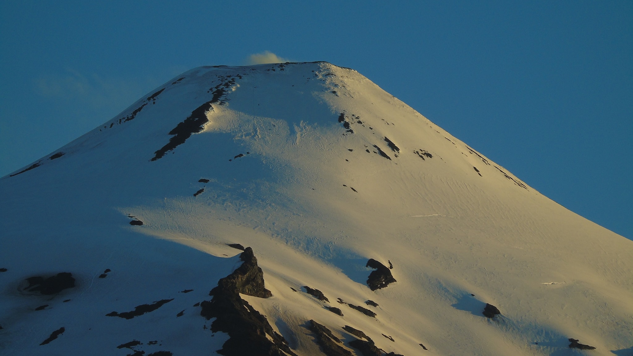
Chile , Villarica :
Long-period type seismic activity and continuous tremor were recorded, both signals being associated with fluid dynamics inside the volcanic building. Regarding LP seismicity, 2142 earthquakes were classified, the sizes of which characterized from the Reduced Displacement (DR) parameter reached a maximum value equal to 33.6 cm2. The continuous tremor seismic signal exhibited fluctuations in magnitude, reaching a maximum DR value equal to 12.1 cm2; some characteristics of the seismic signal of the tremor remained stable (the spectral content oscillated preferably in the range of 0.5 to 2.0 Hz).
– No signal was detected in the acoustic sensors, which are linked to the degassing dynamics of the surface magmatic system.
– In the same way, 5 earthquakes classified as volcano-tectonic (VT) were recorded, commonly associated with processes of rupture of rocky materials. The largest earthquake had a local magnitude (ML) of 1.3 and was located 8.9 km east-southeast of the main crater with a depth of 6.7 km.
– Concerning the surface activity observed from fixed surveillance cameras, whitish gaseous emissions of varying intensity were recorded, with an absence or a very low contribution of particles. The heights of gas columns recorded were less than 1000 m from the edge of the crater.
– According to data provided by 4 GNSS stations, installed around the volcanic building, no evidence of deformation related to changes in the internal dynamics of the volcano was observed.
– No anomalies were reported in sulfur dioxide (SO2) emissions into the atmosphere in the area near the volcano, according to data published by the Tropospheric Monitoring Instrument (TROPOMI) and the Ozone Monitoring Instrument (OMI) Sulfur Dioxide Group.
– During the period, 5 thermal alerts were recorded in the area associated with the volcano, with a maximum power of 1 MW, on October 26, a value considered low according to the data processed by the Middle Infrared Observation of the Volcanic activity (MIROVA). Thanks to the analysis of images from the Sentinel 2L2A satellite, 5 radiance anomalies were detected in the area associated with the crater, on October 7, 10, 12, 17, 27 and 30.

The activity of the Villarrica volcano presented a decrease in seismic productivity and monitoring parameters, an effect similar to that observed in previous months, this behavior suggests a stability of the internal dynamics of the volcanic system. The absence of acoustic signals, a decrease in long-period type activity, and weaker detection of thermal anomalies from satellite images suggest the permanence of the lava lake at deep levels. It is pointed out that the state of the open conduit and the behavior of the fluctuating lava lake can cause explosions that can affect the vicinity of the crater.
Based on the above, the alert is maintained at:
GREEN TECHNICAL ALERT: Active volcano with stable behavior – No immediate risk.
Observation:
Due to the characteristics of the open conduit of the Villarrica volcano, possible minor explosions could affect a radius of 100 m from the edge of the crater.
Source : Sernageomin.
Photos : Franco Vera , Vulcanologia en Chile .
Costa Rica , Turrialba / Poas / Irazu :
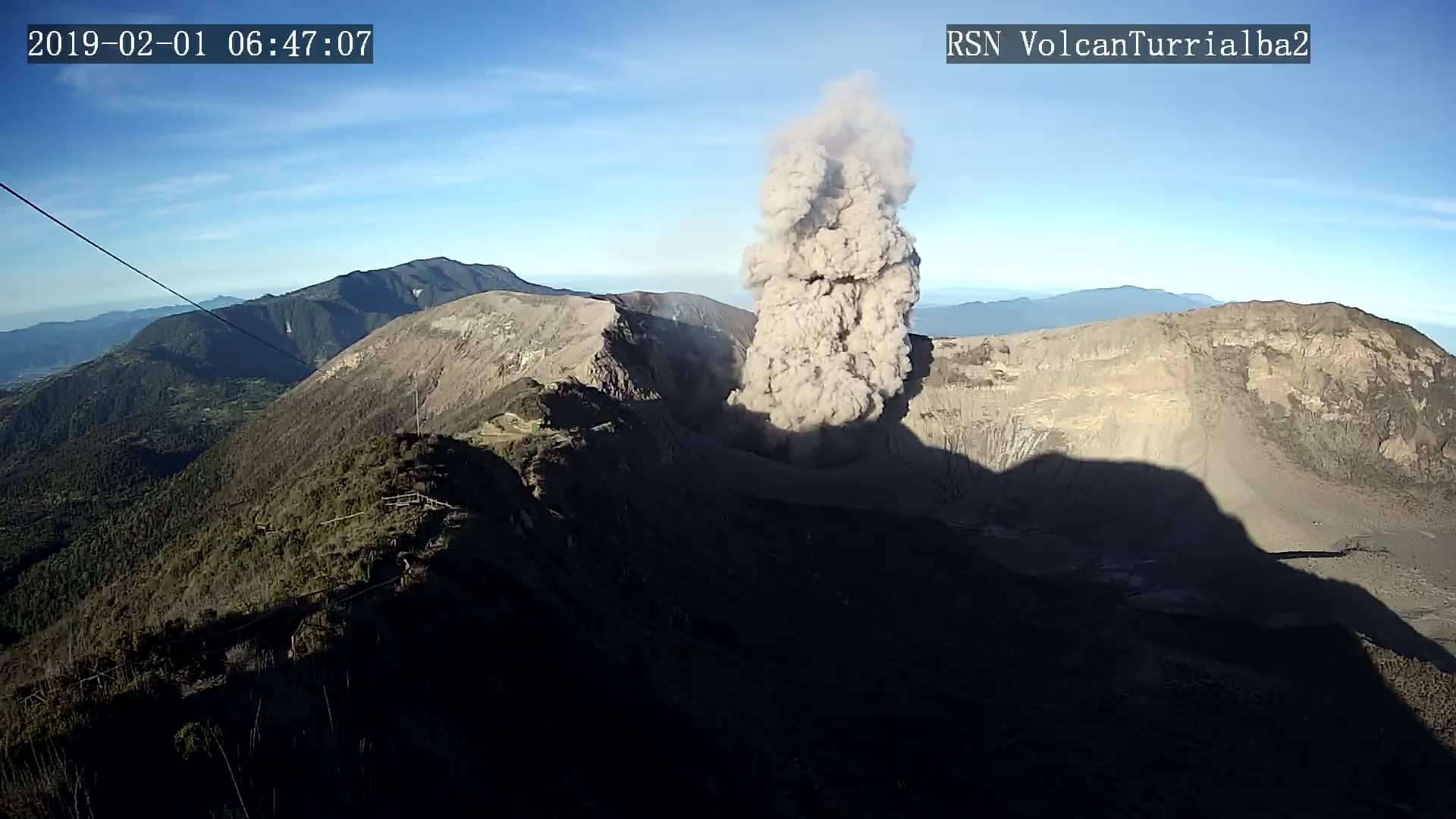
Turrialba volcano.
Lat: 10.025 ° N; Long: 83.767 ° W;
Altitude: 3340 m.s.n.m.
Current activity level: 3 (erupting volcano)
Potentially associated hazards: gas, ash emission, proximal ballistic projections, acid rain.
The volcano erupted 2 times on November 3 and 7 with a confirmed ash emission and 2 possible small eruptions and several rumblings. The eruption of November 3 reached 200 m in height and lasted less than 1 min, the eruption of November 7 was of lower magnitude and could not be observed for climatic reasons. The weekly number of low frequency type earthquakes continues to decrease, there is no change in the characteristics and number of short tremors, proximal VTs. RSEM remains stable and proximal VT-type events that could be localized are superficial.
Geodetic tracking does not show significant short-term deformation and over the past 3 months it shows a tendency to contract. No change is observed in the weekly average of the CO2 / SO2 and H2S / SO2 gas ratios compared to the previous week (CO2 / SO2 = 23.3 +/- 6.47, H2S / SO2 = 0.35 + / – 0.13), but there is an increase in the ratios before the eruption of November 3, and a decrease thereafter. Similar trends were seen on other occasions where no eruption occurred, no clear warning signs were seen prior to the November 7 eruption. The gas emissions are rich in CO2 with SO2 and some H2S, suggesting either a very deep magmatic source or hydrothermal processes. The weekly average SO2 flow has increased compared to the previous week (173 +/- 117 t / d). In detail, an increase was observed a few days before the eruption of November 3 and a decrease after.
The ash that was emitted on November 3 from the West Crater shows very few fragments of juvenile vitreous material (<5%), and abundant porous and lithic material (~ 85%). The chemical analysis of the total ash shows an important phreatic component.
Poas volcano
Lat: 10.2 ° N; Long: 84.233 ° W;
Altitude: 2780 m.s.n.m.
Current activity level: 2 (active volcano)
Potentially associated hazards: gas, phreatic eruptions, proximal ballistic projections, acid rain.
A sudden flow of a jet of hot fluids was observed at the southern edge of the hyperacid lake on November 3, which generated a train of waves that moved and reached the northern edge of the lake, immediately followed by a release of fluids. through the underwater fumarole in the western sector near the « island » which removed the sediment from the bottom of the lake making it gray-green. The first event may have been the result of a landslide or a hydrothermal explosion on the south wall of the lake, which needs to be confirmed in the field.
After this event, a modification of the seismic activity was observed with a decrease in the number of LP-type events, a disappearance of short tremors and proximal VT-type events. Therefore, a decrease in RSEM and DSAR was observed after the event. Geodetic monitoring does not show any significant deformation over a period of 3 months. In the short term, there is a slight tendency to extend but it is not significant. The gas ratios remain stable: SO2 / CO2 = 0.24 +/- 0.06, slightly lower, and H2S / SO2 = 0.02 +/- 0.01. The SO2 flow remains very low, calculating only 29 +/- 10 t / d, a value very close to that of the previous weeks. The SO2 concentration at the watchtower did not exceed 1.6 ppm during the week. The level of the hyperacid lake increased by ~ 20 cm during the week with an evaporation / infiltration rate remaining below the rainfall input.
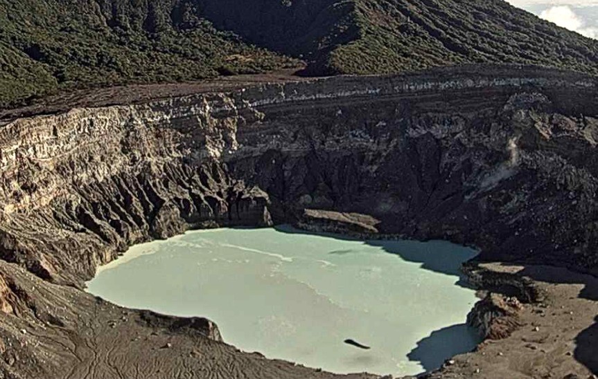
Irazu volcano
Lat: 9.979 ° N; Long: 83.852 ° W;
Altitude: 3432 m.s.n.m.
Current activity level: 1 (active volcano)
Potentially associated risks: landslides, lahars, proximal ballistic projections, acid rain, ash falls, debris avalanches.
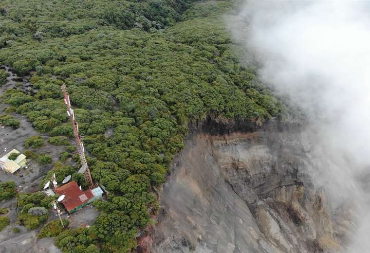
Few VT type events and small landslides are recorded (landslide in the Las Torres sector on November 2, on the eastern flank on November 3, in the main crater sector on November 6). Over the past week, an acceleration of the main landslide has been observed in the area of the communication towers at the top of the Irazú, especially the vertical component in recent days. In addition, the GPS campaigns show an acceleration of the edge of the landslide, with a large block that has separated. Geochemical monitoring of gases in the fumarole field in the northern sector of the volcano shows stability
Source : Ovsicori .
Photos : RSN ( Archive) , Ovsicori , Teletica .
Kamchatka , Karymsky :
VOLCANO OBSERVATORY NOTICE FOR AVIATION (VONA)
Issued: November 14 , 2021
Volcano: Karymsky (CAVW #300130)
Current aviation colour code: ORANGE
Previous aviation colour code: orange
Source: KVERT
Notice Number: 2021-148
Volcano Location: N 54 deg 2 min E 159 deg 26 min
Area: Kamchatka, Russia
Summit Elevation: 1486 m (4874.08 ft)

Volcanic Activity Summary:
The eruptive activity of the volcano continues. Satellite data showed explosions sent ash up to 7.2 km a.s.l., and ash cloud 28×13 km in size to drift for 22 km to the north-east of the volcano.
This activity continues. Ash explosions up to 10 km (32,800 ft) a.s.l. could occur at any time. Ongoing activity could affect international and low-flying aircraft.
Volcanic cloud height:
6500-7200 m (21320-23616 ft) AMSL Time and method of ash plume/cloud height determination: 20211114/0330Z – Himawari-8
Other volcanic cloud information:
Distance of ash plume/cloud of the volcano: 22 km (14 mi)
Direction of drift of ash plume/cloud of the volcano: NE / azimuth 45 deg
Time and method of ash plume/cloud determination: 20211114/0330Z – Himawari-8
Source : Kvert.
Photo : N. Gorbach, IVS FEB RAS.
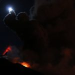
Indonesia , Semeru :
VOLCANO OBSERVATORY NOTICE FOR AVIATION – VONA.
Issued : November 13 , 2021
Volcano : Semeru (263300)
Current Aviation Colour Code : ORANGE
Previous Aviation Colour Code : orange
Source : Semeru Volcano Observatory
Notice Number : 2021SMR64
Volcano Location : S 08 deg 06 min 29 sec E 112 deg 55 min 12 sec
Area : East java, Indonesia
Summit Elevation : 11763 FT (3676 M)
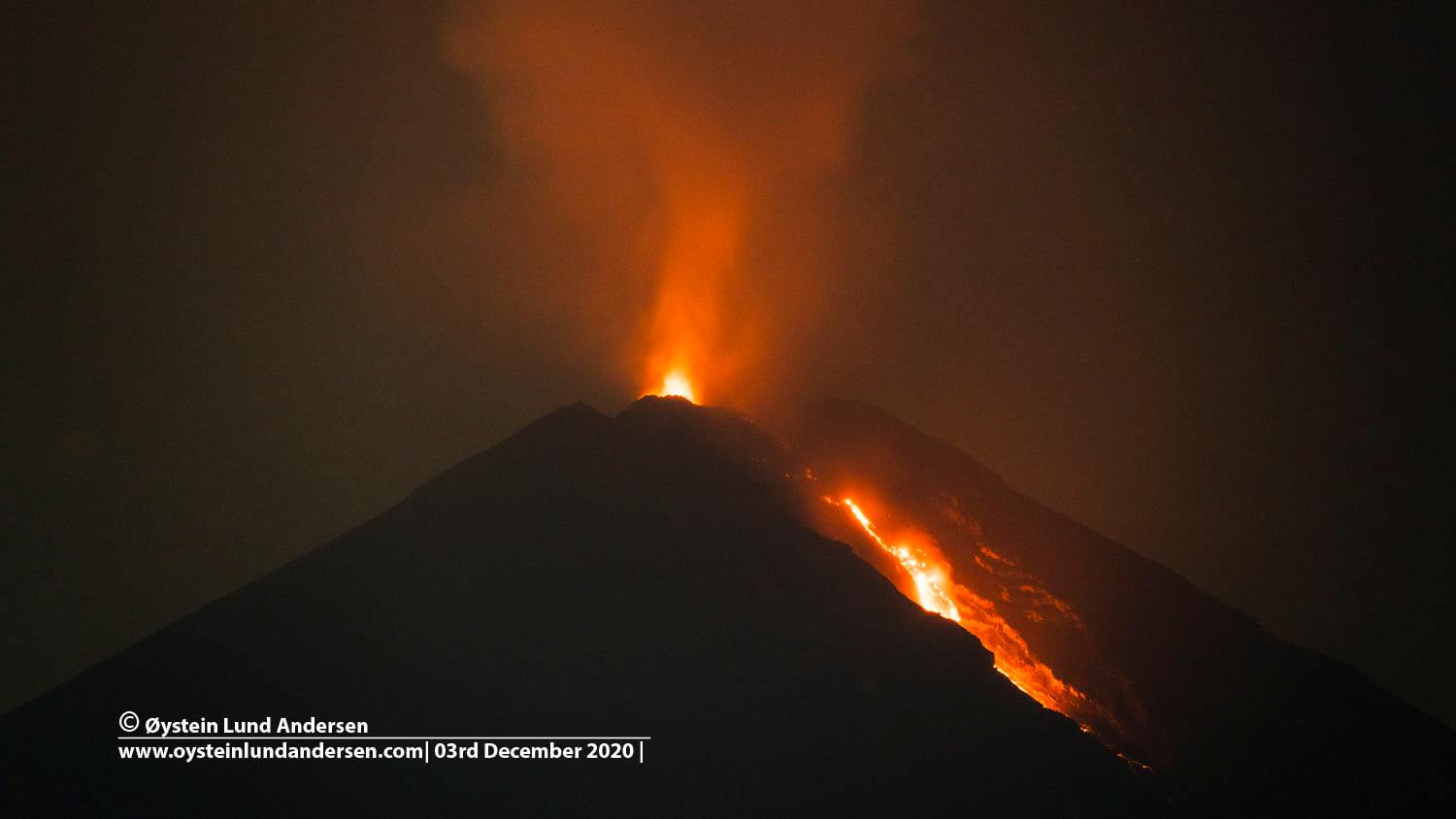
Volcanic Activity Summary :
Eruption with volcanic ash cloud at 22h11 UTC (05h11 local). Eruption and ash emission is continuing.
Volcanic Cloud Height :
Best estimate of ash-cloud top is around 13683 FT (4276 M) above sea level, may be higher than what can be observed clearly. Source of height data: ground observer.
Other Volcanic Cloud Information :
Ash-cloud moving to northwest
Source : Magma Indonésie .
Photo : Oystein lund Andersen .


No comment yet, add your voice below!