
November 05 , 2021.
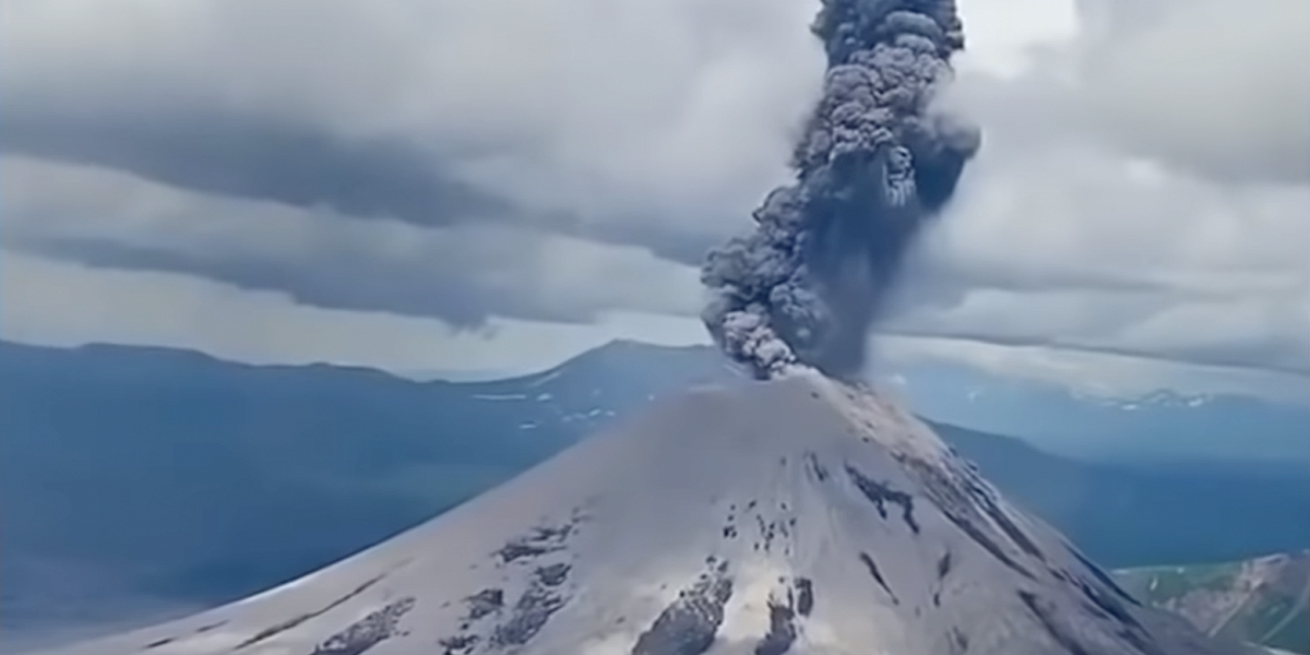
Spain / La Palma , Cumbre Vieja :
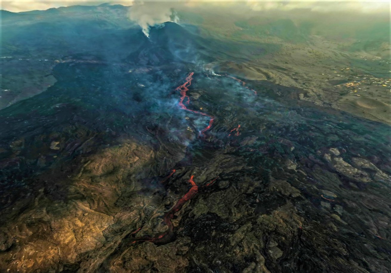
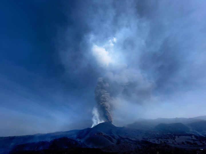
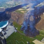
November 04, 2021; 09:00 UTC. Eruptive activity continues on La Palma.
Since the last declaration, 124 earthquakes have been located in the area affected by the volcanic reactivation of Cumbre Vieja, 11 of these earthquakes were felt by the population, having reached the maximum intensity in the epicentral zone III-IV (EMS98) for three earthquakes.
The most significant earthquake was the one which occurred at 10:43 (UTC) yesterday, with a magnitude of 3.7 mbLg at a depth of 14 km and felt with an intensity III-IV on the island of La Palma. In the period considered, 8 earthquakes were located at depths of about 30 km, the rest of the hypocenters of the period are located at a shallower depth, about 12 km.
The amplitude of the volcanic tremor signal shows lower levels, without intensifying pulses.
The island’s network of permanent GNSS stations does not show a clear tendency to warp from stations closest to eruptive centers, while at more distant stations a slight deflation is maintained, possibly related to deep seismicity.
Based on the calibrated image, an emission column height of 3200 m is estimated at 08:48 UTC. and the ash cloud has a South-South-East direction.
The activity levels visible in the cone are highly variable, with occasional high pulses in the lava emission rate. The flow continues west, occasionally overflowing some of the pre-existing volcanic tubes and channels.
Over the next few days, the ash and SO₂ plume is expected to be oriented south-southeast from the eruptive focus, which is a favorable scenario for the aeronautical operation of the airport. from La Palma.
Regarding seismicity, the maximum magnitude was 3.6 mbLg, for a tremor today at 2:11 am at a depth of nine kilometers, felt with maximum intensity II-III (EMS).
There are a total of 460 people staying in hotels, five more than yesterday, including 67 in Los Llanos de Aridane and 393 in Fuencaliente. In addition, 43 dependents continue to be accommodated in island social health centers.
The latest data available on the affected area is estimated at 983.44 hectares, 2.42 more than in the last update (997.9 hectares according to Copernicus). The estimated maximum width of the distance between the flows is approximately 3,100 meters.
According to data provided by Copernicus, the buildings affected amount to approximately 2,712, of which 2,570 were completely damaged and 142 partially damaged.
Sources : IGN es , El Pais .
Photos : I Love the world , David Rosario Fotografía .
Hawaii , Kilauea :
19°25’16 » N 155°17’13 » W,
Summit Elevation 4091 ft (1247 m)
Current Volcano Alert Level: WATCH
Current Aviation Color Code: ORANGE
Activity Summary:
Kīlauea volcano is erupting. As of this morning, November 4, 2021, lava continues to erupt from a single vent in the western wall of Halemaʻumaʻu crater. All lava activity is confined within Halemaʻumaʻu crater in Hawai‘i Volcanoes National Park. Seismic activity and volcanic gas emission rates remain elevated.
Summit Observations:
Sulfur dioxide (SO2) emission rates remain high, with a preliminary emission rate for October 28, 2021, of at least 3,600 tonnes per day. Summit tilt and GPS observations show no or minimal deformation over the past week. Earthquake activity remains below background and volcanic tremor remains elevated since the beginning of the eruption.
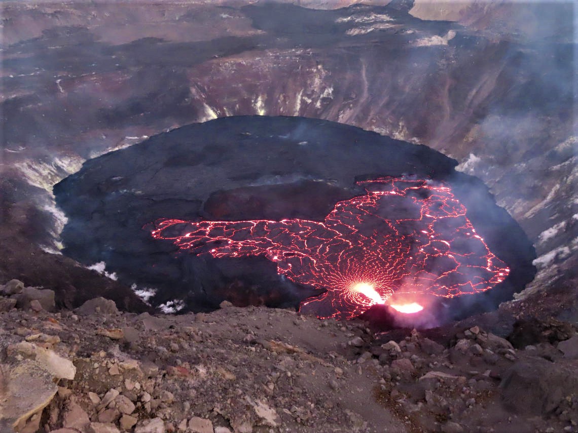
The extent of the active surface of the lava lake (orange) within Halema‘uma‘u crater, at the summit of Kīlauea, is clearly delineated as the sun sets on November 2, 2021. Photo taken at 5:56 p.m. HST from the west rim.
Halemaʻumaʻu Lava Lake Observations:
Lava continues to erupt from a single vent in the western wall of Halemaʻumaʻu crater. The western end of the lake showed a maximum elevation of approximately 798.5 meters (2620 ft) above sea level by HVO’s permanent laser rangefinder on November 4, 2021, which is about 0.5 m (1.5 ft) above the previous day, and a total increase of about 55 meters (180 ft) since lava emerged on September 29. The total erupted volume since the beginning of the eruption was estimated to be about 19.9 million cubic meters (5.3 billion gallons) on October 15. Field crews on November 3, 2021 observed roiling and low spattering in the lava pond within the western vent. The short channel leading from the pond within the vent cone into the lava lake is now covered with a cooled crust. The lava lake is not level across its surface due to the location of the vent on the western side. There is about 7 meters (23 feet) elevation difference between the active west and stagnant east part of the lake.
Source : HVO.
Photo : USGS/J.M. Chang.
Alaska , Semisopochnoi :
51°55’44 » N 179°35’52 » E,
Summit Elevation 2625 ft (800 m)
Current Volcano Alert Level: WATCH
Current Aviation Color Code: ORANGE
Eruptive activity continues at the north crater of Mount Cerberus. Explosions and tremor were detected in seismic data over the past day. Low-level ash emissions were observed in web camera data during periods of clear weather. No ash emissions were observed in satellite data rising above the meteorological cloud deck, which had an estimated cloud top altitude of 10,000 ft asl.
Small eruptions producing minor ash deposits within the vicinity of the active north crater of Mount Cerberus and ash clouds usually under 10,000 feet above sea level have characterized the recent activity, which shows no signs of abating. Small explosions may continue to occur and could be difficult to detect, especially during poor weather conditions.
Semisopochnoi is monitored by local seismic and infrasound sensors, satellite data, web cameras, and remote infrasound and lightning networks.
Source : AVO.
Photo : Christ Aaron / U.S. Fish and Wildlife Service
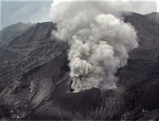
Kamchatka , Karymsky :
54.05 N, 159.44 E;
Elevation 1486 m (4874 ft)
Aviation Colour Code is ORANGE
A moderate eruptive activity of the volcano continues. Ash explosions up to 10 km (32,800 ft) a.s.l. could occur at any time. Ongoing activity could affect international and low-flying aircraft.
This activity continues. According to satellite data by KVERT, ash emissions from the volcano up to 4 km a.s.l. was noted all week, ash plumes extended for 135 km to the east and southeast of the volcano. On 03 November, a powerful explosive event occurred with the rise of an eruptive cloud up to 9.5 km a.s.l. and then up to 10.5 km a.s.l. The ash cloud stretched for 2250 km over the Pacific Ocean on 03-04 November, the frontal eastern part of the cloud moves further to the east, the western part – to the northeast of the volcano. Probably, on 04 November, ashfalls were and are observed from 00:00 to 04:30 UTC and from 20:00 UTC at Medny Island, and from 19:00 UTC at Bering Island. A thermal anomaly was observed over the volcano crater all week.
Source : Kvert.
Photo : Daily Afisha. Ru
Ecuador , Sangay :
DAILY REPORT ON THE STATE OF SANGAY VOLCANO.
Surface activity level: High, Surface trend: No change.
Internal activity level: High, Internal trend: No change.
Seismicity: From November 03, 2021, 11:00 a.m. to November 04, 2021, 11:00 a.m .:
There was no cut in the transmission of data from the reference station for seismic statistics
Long period type events (LP) 9
Explosions (EXP) 82
Emission Tremors (TREMI) 70
Rains / Lahars:
There was no rain in the area. ** In the event of heavy rains, they could re-mobilize the accumulated material, generating mudslides and debris that would descend the sides of the volcano and flow into the adjacent rivers.
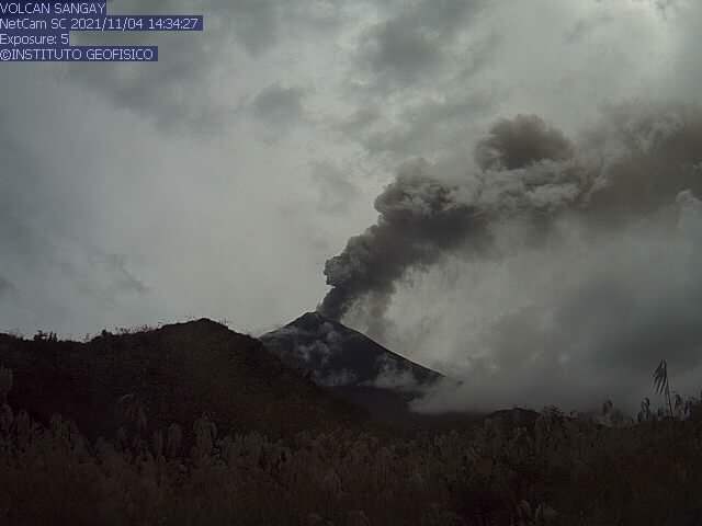
Emission column / ash:
Today in the morning, several gas emissions were observed which reached heights of up to 1000 meters above the crater level, the direction of these emissions was constant towards the South. The VAAC recorded 2 ash emission alerts observed by satellites that reached heights of 600 and 1200 meters above the crater level in a southerly direction.
Other monitoring parameters:
FIRMS reported 4 thermal alerts on the Sangay in the last 24 hours. MIROVA reported 1 moderate thermal alert over the Sangay in the last 24 hours.
Observation:
In the afternoon of yesterday, the volcano remained cloudy. Today in the morning it was cloudy, however, the emissions described above were observed. At the close of this bulletin, no ash fall report has been recorded.
Alert level: yellow.
Source et photo : IGEPN.
Japan , Suwanosejima :
JMA reported that an explosion at 1317 on 26 October at Suwanosejima’s Ontake Crater produced an eruption plume that rose as high as 3.3 km above the crater rim and ejected material 1.9 km away from the crater. Ashfall was reported in Toshima village (4 km SSW). No explosions were recorded during 29 October-1 November, though eruption plumes rose as high as 2.4 km and tephra was ejected 400 m from crater. The Alert Level remained at 3 and the public was warned to stay 2 km away from the crater.
The 8-km-long, spindle-shaped island of Suwanosejima in the northern Ryukyu Islands consists of an andesitic stratovolcano with two historically active summit craters. The summit is truncated by a large breached crater extending to the sea on the east flank that was formed by edifice collapse. Suwanosejima, one of Japan’s most frequently active volcanoes, was in a state of intermittent strombolian activity from Otake, the NE summit crater, that began in 1949 and lasted until 1996, after which periods of inactivity lengthened. The largest historical eruption took place in 1813-14, when thick scoria deposits blanketed residential areas, and the SW crater produced two lava flows that reached the western coast. At the end of the eruption the summit of Otake collapsed forming a large debris avalanche and creating the horseshoe-shaped Sakuchi caldera, which extends to the eastern coast. The island remained uninhabited for about 70 years after the 1813-1814 eruption. Lava flows reached the eastern coast of the island in 1884. Only about 50 people live on the island.
Sources: Japan Meteorological Agency (JMA) , GVP.
Photo : Taken from a helicopter of Kagoshima Prefecture by JMA


No comment yet, add your voice below!