
October 06 , 2021.
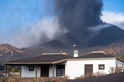
Spain / La Palma , Cumbre Vieja :
The DSN warns that an increase in explosiveness may occur.
The lava affects an area of 413.38 hectares, with a perimeter of 36.3 kilometers and a maximum width of 1,250 meters, and the delta covers 32.7 hectares and continues to increase, the department of Homeland Security (DSN). The air quality forecast is favorable thanks to improving weather conditions.
The DSN warns that an increase in explosiveness may occur. The seismicity has increased slightly and it is in principle excluded that it could give rise to the opening of a new mouth. In the past 24 hours, dozens of earthquakes have been recorded, including one of magnitude 3.9.
Seismic activity intensifies and a magnitude 3.9 earthquake is recorded
The National Geographic Institute (IGN) has recorded more than thirty earthquakes in recent hours, including the one with the highest magnitude of 3.9, located in Villa de Mazo at a depth of 38 kilometers, at 4:36 a.m. Another magnitude 3.4 earthquake was also located in Mazo, at a depth of 37 kilometers, which was felt by the population at 5:18 am.
As in previous days, practically all earthquakes have an epicenter in Mazo and Fuencaliente, although the IGN reports one in Breña Baja, of magnitude 2.8, and another in Frontera, on the island of El Hierro, magnitude 2.6. Of the thirty earthquakes recorded in the past nine hours, ten had a magnitude greater than three. The depth varies between eight kilometers for the shallowest and 38 kilometers for the 3.9 earthquake.
05 October 2021 13:00 UTC. Eruptive activity continues on La Palma.
Since the last declaration, 75 earthquakes have been located in the southern part of the island of La Palma, near the ongoing volcanic eruption. Seventeen of them were felt by the population and a maximum intensity value of III-IV (EMS) was reached in the epicentral zone of two of the earthquakes that occurred at 14:30 UTC and 18:58 UTC yesterday, both earthquakes of magnitude 3.7 (mbLg).
An increase is observed both in the number of earthquakes and in their magnitudes compared to previous days, 7 of the recorded earthquakes have a magnitude greater than or equal to 3.5 (mbLg).
As in previous days, most of the seismicity is located 10-15 km deep, in the area where the swarm started on September 11, although 7 of them are located deeper, between 25 and 40 km.
The average amplitude of the volcanic tremor shows a slight gradual increase since yesterday morning and continues in the same average range of values compared to that observed in this eruption. No significant pulse has been recorded in the past 24 hours. The height of the column measured at 7:30 UTC is 4000 m, showing a slight descent of the eruptive cloud.
The island’s network of permanent GNSS stations shows slight deflation in the vertical component of stations near eruptive centers. These results are consistent with those obtained by InSAR in which we can see an area that presents a pattern compatible with a possible subsidence between the Sentinel1 images of September 28 and October 4.
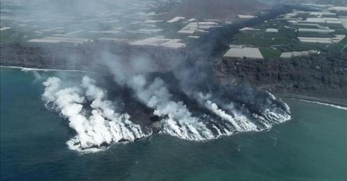
After 17 days of activity, the volcanic eruption of La Palma destroyed 726 buildings, including 605 homes; 58, buildings for agricultural use, 30 for industrial use, 18 for leisure and hospitality, seven for public use, and eight other buildings not specified, according to land registry data. The lava affects an area of 420.12 hectares, with a perimeter of 36.24 kilometers and a maximum width of 1,250 meters. The lava platform that has won over the sea exceeds 36 hectares and continues to grow.
Source : El Pais , Involcan.
Photos : El Pais , lavanguardia .
Video : CSIC
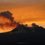
Italy / Sicily , Etna :
Weekly Bulletin from September 27, 2021 to October 03, 2021 (issue date October 05, 2021)
SUMMARY STATEMENT OF ACTIVITY
In view of the monitoring data, it is highlighted:
1) VOLCANOLOGICAL OBSERVATIONS: Degassing activity at summit craters
2) SEISMOLOGY: Weak seismic activity of fracturing; average amplitude of the volcanic tremor in the low level.
3) INFRASOUND: Moderate infrasound activity
4) DEFORMATIONS: No significant deformation of the ground was observed during the last week.

5) GEOCHEMISTRY: SO2 flux at an average level
The flow of CO2 emitted by the soils has shown a significant decrease in recent days and is at average values.
The partial pressure of CO2 dissolved in water shows no significant change.
The helium isotope ratio shows a slight decrease compared to previous data but it is still at medium-high values (latest data from 9/21/2021).
There are no updates for the C / S report.
6) SATELLITE OBSERVATIONS: After the lava fountain of September 21, 2021, thermal activity in the summit area was at a low level.
VOLCANOLOGICAL REMARKS
During the week, the monitoring of the volcanic activity of Etna was carried out by analyzing the images of the surveillance cameras of the INGV, Osservatorio Etneo (INGV-OE)
and by an inspection in the summit area by INGV staff on September 30.
Due to cloud cover, it was not possible to observe continuous volcanic activity.
Overall, the activity of the summit craters was characterized by a variable degassing regime. The figure also shows the flow map produced by the Southeast Crater (SEC) on September 21. In particular, the flow map was produced using the Sentinel 2 images from September 21 and 24.
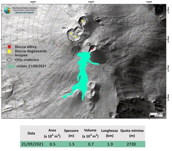
Fig. 3.1 – Map of the flow of September 21 and the summit craters of Etna. The morphological update of the SEC dated September 16, 2021. BN: Bocca Nuova, VOR: Voragine; NEC: Northeast Crater; SEC: Southeast Crater. The topographic reference base on which the morphological updates have been superimposed is the DEM 2014 developed by the Aerogeophysical Laboratory-Section Rome 2
On September 30, an inspection was carried out in the summit area by INGV-OE personnel. The summit craters were affected by intense degassing which partially obscured direct observation; from the analysis of the images obtained thanks to the use of a thermal camera installed on a drone, it was possible to verify that the Bocca Nuova did not present thermal anomalies and that the Southeast Crater was affected by warmer areas, likely caused by fumarolic activity present along the northwest side near the crater rim and the eruptive fracture that fueled the September 21 flow.
Source : INGV.
Photos : Gio Giusa , INGV.
Hawaii , Kilauea :
19°25’16 » N 155°17’13 » W,
Summit Elevation 4091 ft (1247 m)
Current Volcano Alert Level: WATCH
Current Aviation Color Code: ORANGE
Activity Summary:
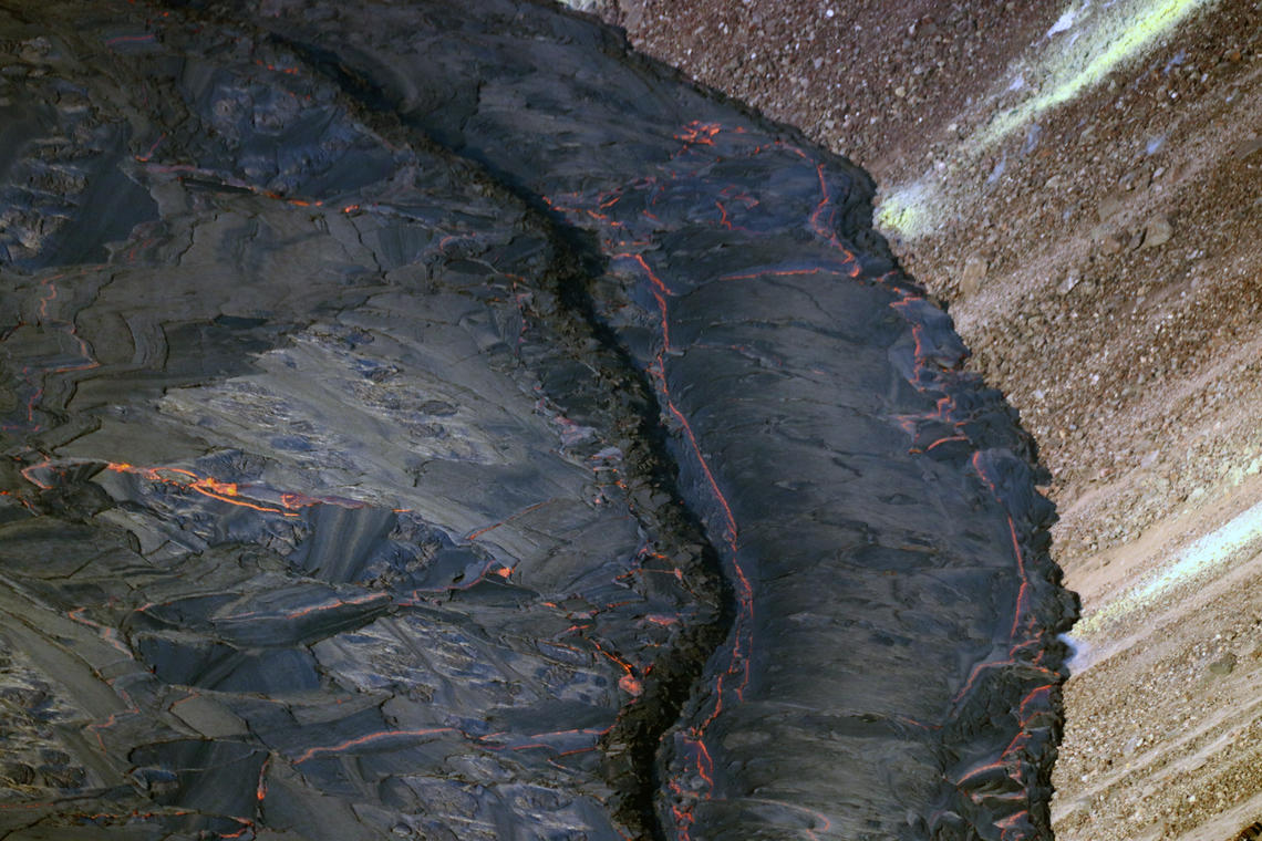
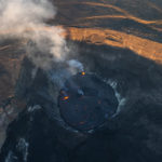
Kīlauea volcano is erupting. Lava continues to erupt from multiple vents along the floor and western wall of Halemaʻumaʻu crater. As of this morning, October 5, 2021, all lava activity is confined within Halemaʻumaʻu in Hawai‘i Volcanoes National Park. Seismicity and volcanic gas emission rates remain elevated.
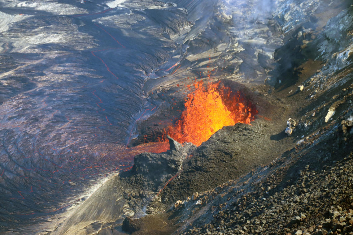
A telephoto view of fountaining at the western vent in Halema‘uma‘u crater, at the summit of Kīlauea. Spatter from the fountain has built a horseshoe-shaped cone around the vent in the western crater wall. Molten spatter accumulating on the cone forms a tiny stream of lava down the north side (bottom center). This photo was taken on October 4, 2021, from the northwest caldera rim.
Summit Observations:
Sulfur dioxide (SO2) emission rates remain high, with preliminary measurements of approximately 7,000 – 9,000 tonnes per day on October 4, 2021. Seismicity remains elevated but stable. Summit tiltmeters continue to record deflationary tilt.
Halemaʻumaʻu Lava Lake Observations:
Lava continues to erupt from multiple vents within Halemaʻumaʻu. Over the past 24 hours, the lava lake level has risen approximately 1 meter (3 ft). The west vent continues to be the most vigorous source, with sustained lava fountain heights of 13–16 meters (43–52 ft), and bursts up to 20 meters (66 ft) observed. The lava lake has risen to the base of the west vent, around which a spatter rampart is being built. Other vents continue to be active in the southern part of the lake, with sustained lava fountain heights of 1–5 meters (about 3–16 ft). Due to the location of vents, the lava lake is not level across its surface; areas closer to vents are higher in elevation. Yesterday evening, the west and south ends of the lake were 1–2 meters (about 3–7 ft) higher than the east and north ends. The north and east boundaries of the lava lake are separated from Halemaʻumaʻu crater wall by narrow ledges, approximately 20-meters wide (66 ft), that are lower in elevation than the active portion of the lava lake surface; the north, east, and south sides of the lava lake are perched several meters (yards) above this surrounding ledge. Localized and discontinuous crustal foundering continues (a process by which cool lava crust on the surface of the lava lake is overridden by less-dense liquid from below causing the crust to sink into the underlying lake lava).
An overflow of lava from the active lake (left) poured onto and along the levee (right) on the eastern end of the lava lake in Halema‘uma‘u crater, at the summit of Kīlauea.
East Rift Zone Observations:
No unusual activity has been noted in the Kīlauea East Rift Zone. Ground deformation motion suggests that the upper East Rift Zone—between the summit and Puʻuʻōʻo—has been steadily refilling with magma over the past year. SO2 and hydrogen sulfide (H2S) emissions from Puʻuʻōʻō were below instrumental detection levels when last measured on January 7, 2021.
Source : HVO
Photos : USGS / M. Patrick.
Italy , Stromboli :
Weekly Bulletin from September 27, 2021 to October 03, 2021 (issue date October 05, 2021)
SUMMARY STATEMENT OF ACTIVITY.
In view of the monitoring data, it is highlighted:
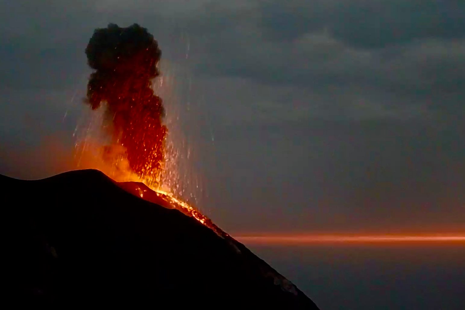
1) VOLCANOLOGICAL OBSERVATIONS: During this period a normal explosive activity of strombolian type was observed. The total hourly frequency of explosions fluctuated between medium and medium-high values (12-18 events / h). The intensity of the explosions varied from low to high in both the North crater area and the Center-South area.
2) SEISMOLOGY: The seismological parameters monitored do not show significant variations.
3) DEFORMATIONS: The island’s soil deformation monitoring networks have not shown any significant changes over the past week.
4) GEOCHEMISTRY: The flow of SO2 at a medium-low level
The flow of CO2 emitted by the ground on the Pizzo Sopra la Fossa is at medium-high levels.
The weekly average C / S ratio is at high values (C / S = 14.58).
There is no update regarding the isotopic ratio of Helium dissolved in the thermal aquifer. The last digit has been placed on high values.
5) SATELLITE OBSERVATIONS: The thermal activity in the summit area is at a low level.
VOLCANOLOGICAL REMARKS
During the observation period, the eruptive activity of Stromboli was characterized by the analysis of the images recorded by the surveillance cameras of the INGV-OE (altitude 190m, Punta
Corvi, altitude 400m and Pizzo).
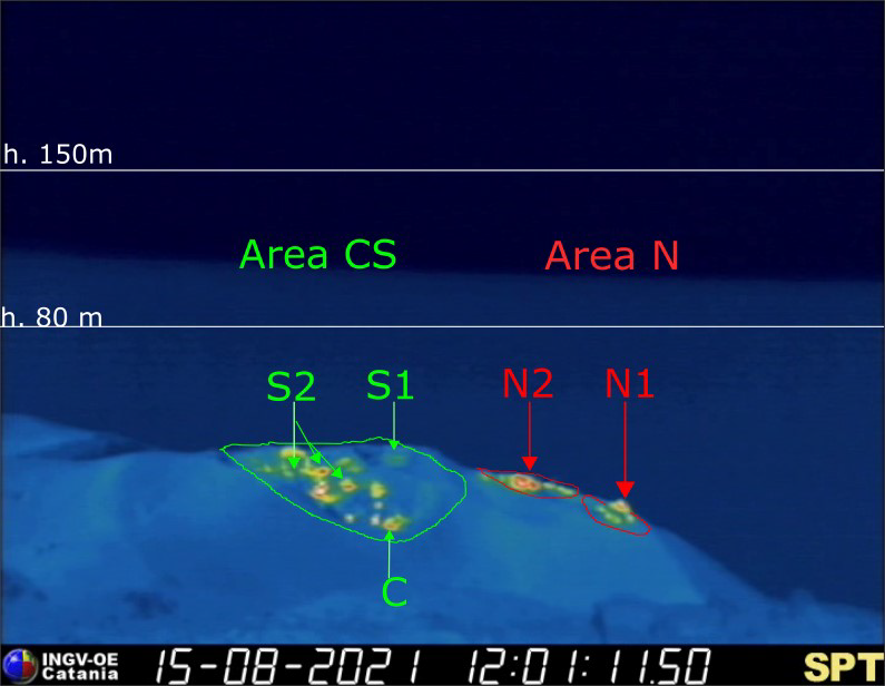
The explosive activity was mainly produced by 4 (four) eruptive chimneys located in the North crater area and 5 (five) eruptive chimneys located in the Center-South crater area. All the vents are placed inside the depression which occupies the terrace of the crater.
Due to adverse weather conditions, the visibility of the crater terrace on September 29 was not sufficient for a correct description of the explosive activity.
Sector N1 located in the North zone, with two emission points, produced explosions of varying intensity from weak (less than 80 m in height) to strong (sometimes the products exceeded 150 m in height) emitting fine materials (ash) mixed with coarse materials (lapilli and bombs).
Sector N2, with two emission points, showed low intensity explosive activity (less than 80 m in height) emitting coarse materials. The northern vent of sector N2 has been in explosive continuity since October 2. The average frequency of explosions varied from 4 to 10 events / h.
In the Center-South zone, sector S1 exhibited a low-intensity explosive activity of fine material, while the three vents placed in sector S2 produced explosions, even simultaneously, of varying intensity, from low to high (the products some explosions exceeded 150 m) emitting coarse material mixed with fine material. Sector C produced an intense degassing activity interrupted by modest explosions of coarse materials. The frequency of the explosions varied from 6 to 12 events / h.
Source : INGV.
Photos : INGV, Webcam.
Colombia , Nevado del Ruiz :
Weekly activity bulletin of the Nevado del Ruiz volcano
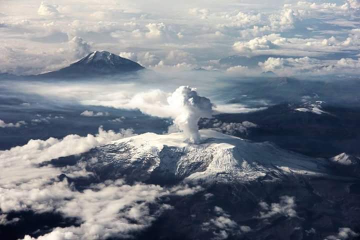
The activity level continues at: Yellow activity level or (III): Changes in the behavior of volcanic activity.
Regarding the monitoring of the activity of the Nevado del Ruiz volcano, the COLOMBIAN GEOLOGICAL SERVICE reports that:
The seismicity generated by rock fracturing increased in number of earthquakes and seismic energy released, compared to the previous week. This seismic activity was mainly localized in the southwest, southeast, distal north sectors of the volcano, in the Arenas crater and to a lesser extent in the northeast volcanic sector. The depths of the earthquakes ranged from 0.6 to 8.7 km.
The highest magnitude recorded during the week was 1.5 ML (Local Magnitude), corresponding to the earthquake that occurred on October 1 at 9:10 p.m. (local time), located 2.3 km southwest of the Arenas crater, at a depth of 3.5 km.
There were several episodes of low energy drumbeat type seismicity associated with rock fracturing on September 30 and October 2. This seismicity has been linked
with the processes of ascension, localization-growth and evolution of a lava dome at the bottom of the Arenas crater.
Seismicity related to fluid dynamics inside volcanic conduits decreased in number of recorded earthquakes and released seismic energy, compared to the previous week. This type of seismicity was characterized by the recording of continuous volcanic tremors of low energy, tremor pulses, long and very long period earthquakes with varying energy levels. These earthquakes showed variable spectral characteristics and were located mainly in the Arenas crater.
Source : Ingeominas.
Photo : Auteur inconnu.


No comment yet, add your voice below!