
October 01 , 2021.
Hawaii , Kilauea :
19°25’16 » N 155°17’13 » W,
Summit Elevation 4091 ft (1247 m)
Current Volcano Alert Level: WARNING
Current Aviation Color Code: RED
Activity Summary:
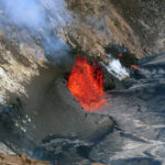
Kīlauea volcano is erupting. Lava continues to erupt from multiple vents along the floor and western wall of Halemaʻumaʻu crater. As of this afternoon all lava activity is confined within Halemaʻumaʻu Crater. Seismicity and volcanic gas emission rates remain elevated.
Summit Observations:
Sulfur dioxide emission rates remain high and were estimated at around 85,000 tonnes per day just after the eruption started, yesterday afternoon at 3:21 p.m. HST. Seismicity is elevated but stable, with few earthquakes and ongoing volcanic tremor. Summit tiltmeters continued to record slowing deflationary tilt through this afternoon.
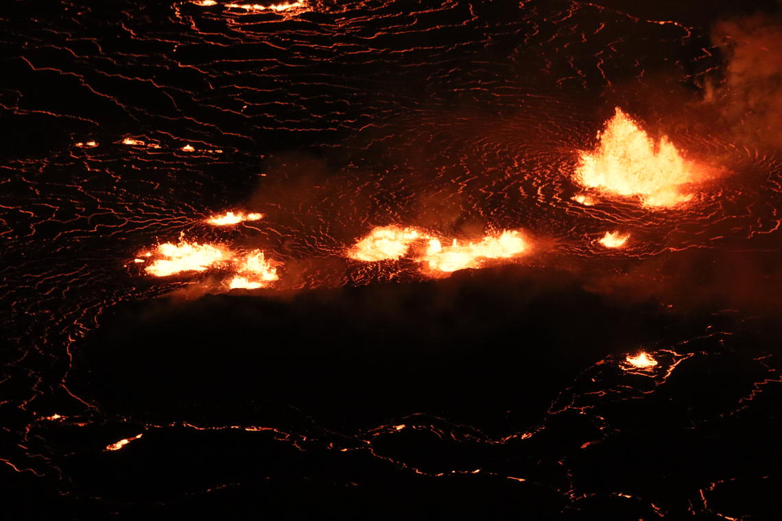
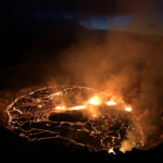
The ongoing Kīlauea summit eruption within Halema’uma’u crater continues to feed low lava fountains in the center of the lava lake (pictured) and along the western wall of Halema’uma’u. This telephoto image is looking east at the center of the rising lava lake. The solid dark area below the fountains is the « lava island » that formed in December 2020 in the opeining hours of the last summit eruption.
Halemaʻumaʻu Lava Lake Observations:
The lava lake has been rising approximately one meter (yard) an hour since the eruption began. The lava lake has not exhibited widespread circulation overnight, with localized and discontinuous areas of crustal foundering (a process by which cool lava crust on the surface of the lava lake is overridden by less-dense liquid from below causing the crust to sink into the underlying lake lava). The maximum fountain height so far, observed yesterday, was estimated to be 25-30 m (82-98 ft) high, though most fountains are currently only a few meters (yards) high.
East Rift Zone Observations:
No unusual activity has been noted in the Kīlauea East Rift Zone. Ground deformation motion suggests that refilling of the upper East Rift Zone—between the summit and Puʻuʻōʻo — may have slowed slightly since the recent August intrusion. SO2 and hydrogen sulfide (H2S) emissions from Puʻuʻōʻō were below instrumental detection levels when last measured on January 7, 2021.
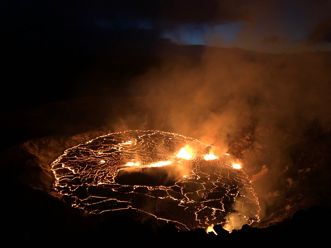
The eruption within Halema’uma’u, at Kīlauea summit within Hawai’i Volcanoes National Park, continues at dawn on September 30, 2021. Fountaining at multiple fissure locations on the base and west wall of the crater continues, and a lava lake is growing within Halema’uma’u.
Hazard Analysis:
This new eruption at Kīlauea’s summit is occurring within a closed area of Hawai’i Volcanoes National Park. Therefore, high levels of volcanic gas are the primary hazard of concern, as this hazard can have far-reaching effects down-wind. Large amounts of volcanic gas—primarily water vapor (H2O), carbon dioxide (CO2), and sulfur dioxide (SO2)—are continuously released during eruptions of Kīlauea Volcano. As SO2 is released from the summit, it reacts in the atmosphere to create the visible haze known as vog (volcanic smog) that has been observed downwind of Kīlauea. Vog creates the potential for airborne health hazards to residents and visitors, damages agricultural crops and other plants, and affects livestock.
Source : HVO.
Photos : USGS / M. Patrick , USGS / B. Carr.
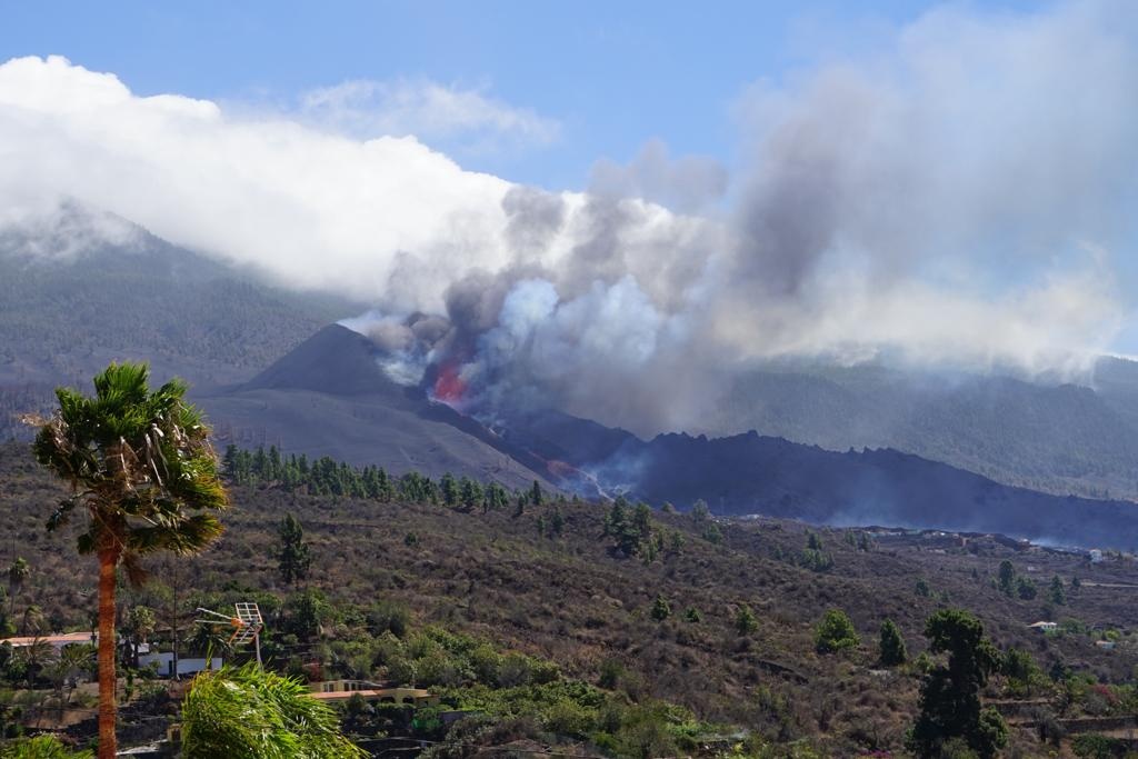
Spain / La Palma , Cumbre Vieja :
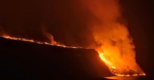
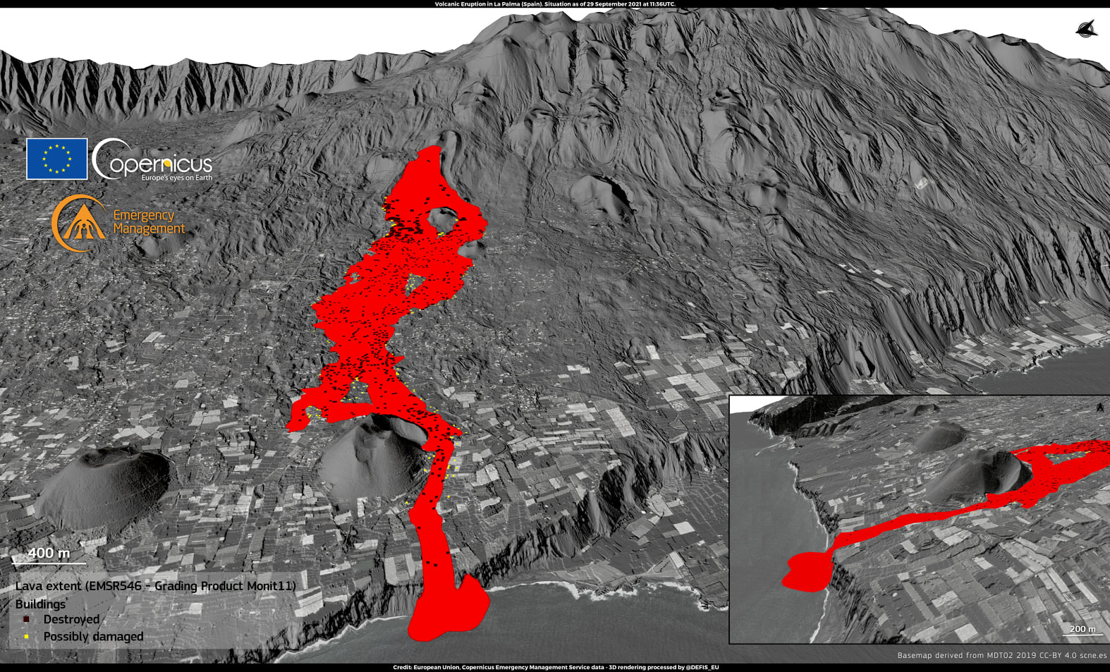
Lava emanating from the Cumbre Vieja volcano in La Palma has gained 8.8 hectares of the sea, according to the latest measurements from Copernicus, the European Union’s Earth observation program. The magma has already affected an area of 476 hectares and the damaged buildings amount to 981. 855 in their entirety and 126 partially, while the destroyed roads total 27.4 kilometers. This Thursday, the volcano maintains its activity unchanged from the day before, with a continuous flow in the form of a waterfall.
Residents will be able to temporarily return home to collect their belongings, still outside the 2.5-kilometer exclusion perimeter. Farmers from Puerto Naos, El Remo and Las Hoyas are also allowed to visit their farms for irrigation tasks. The intense winds that will blow across the Canary Islands over the next two days will disperse emissions from the volcano towards the Atlantic Ocean and ensure air quality in populated areas, reports the State Meteorological Agency (Aemet ).
The National Geographic Institute located an earthquake of magnitude 3.1 on the Richter scale in the municipality of Fuencaliente, at a depth of 13 kilometers, at 8:23 a.m.
Since the afternoon of this Wednesday there have been more than a dozen earthquakes in the regions of Fuencaliente and Mazo, all at depths between 10 and 14 kilometers, and two of them with magnitudes of 3.3 and 3.4.
The volcano increases its explosiveness and its gas emissions
On Thursday, sulfur dioxide values rose in Tazacorte and Los Llanos, experts explained that these were one-off increases at the moment, they do not represent a danger to the population. « These values recorded continuously in air quality stations presently do not present any danger to health and are due to the state of the volcanic plume in the region », said Maria Jose Blanco, director of the Geographical Institute National Canary Islands (IGN). The explosive activity of the Cumbre Vieja volcano in La Palma has increased again in recent hours, as have gas emissions in the northern part, the National Geographical Institute confirmed on Thursday.
30 September 2021 14:00 UTC
Eruptive activity continues in La Palma
Since the last press release, a total of 18 earthquakes have been located in the southern area of the island of La Palma, 4 of which are very weakly felt by the population. One of them was located on the west coast of the island while the rest are between 10 and 14 km deep in the area where the reactivation that preceded the eruption began. The maximum magnitude is 3.3 (mbLg) for two of them.
As on the previous day, the average amplitude of the volcanic tremor has remained very stable over the past 24 hours, within a range of average values compared to the values observed since the start of the eruption. The network of permanent GNSS stations on the island shows a return to stability in the deformations. Today at 12:06 (UTC), due to the height increase reached by the eruption cloud, IGN issued a new VONA (Volcano Observatory Notice for Aviation) message indicating that the current height of the cloud of ash is 5000 m above sea level.
Sources : El Pais.
Photos :
Cartes : El Pais.
Chile , Chaiten :
Special Report on Volcanic Activity (REAV), Los Lagos Region, Chaitén Volcano, September 28, 2021, 08:20 Local time (Continental Chile).
The National Service of Geology and Mines of Chile (Sernageomin) publishes the following PRELIMINARY information, obtained thanks to the monitoring equipment of the National Volcanic Surveillance Network (RNVV), processed and analyzed at the Volcanological Observatory of the Southern Andes (Ovdas) :
This Tuesday, September 28 at 07:32 local time (10:32 UTC), the monitoring stations installed in the vicinity of the Chaitén volcano recorded an earthquake associated with both fracturing and fluid dynamics inside the volcanic system. (hybrid type).

The characteristics of the earthquake after its analysis are as follows:
ORIGINAL TIME: 07:32 local time (10:32 UTC)
LATITUDE: 42.823 ° S
LONGITUDE: 72.656 ° W
DEPTH: 3.0 km
Local magnitude (ML): 2.8
Reduced displacement (DR): 632 cm2
The characteristics of the associated surface activity are as follows:
MAXIMUM HEIGHT OF THE COLUMN: 80 meters above the point of emission
OBSERVATIONS:
From the images available, no change in surface activity was observed. Also, the seismic activity remains in its baseline state after the reported event.
The volcanic technical alert remains at Green level.
Source : Sernageomin.
Photo : Christian Brown.
La Réunion , Piton de la Fournaise :
Seismicity
In September 2021, the OVPF recorded in the Piton de la Fournaise massif a total of:
• 52 superficial volcano-tectonic earthquakes (0 to 2.5 km above sea level) below the summit craters;
• 1 deep earthquake (below sea level);
• 299 collapses (in the Crater Dolomieu, the ramparts of the Enclos Fouqué and Piton de Crac, and the Rivière de l’Est).
The seismicity under the Piton de la Fournaise during the month of September 2021 remained low with an average of 2 superficial volcano-tectonic earthquakes per day.
A slight increase in the most superficial seismicity (between 0 and 2 km above sea level) was nevertheless recorded between September 20 and 27 with an average of 4 events per day under the Dolomieu crater.
This seismicity is most certainly linked to a disturbance of the superficial hydrothermal system linked to the rise of deep heat.
Deformation
The building’s inflation, which began in April 2021, continued throughout September 2021.
This inflation showed a pressurization of the superficial magmatic reservoir located around 1.5-2 km deep.
CO2 concentration in the soil
Following the eruption of December 2020, a continuous increase in CO2 emissions from the soil was recorded at the level of the distal sites (Plaine des Cafres sectors) but also proximal (Gîte du volcano).
At remote sites, a trend reversal (drop in CO2 emissions) occurred on February 12, 2021, witnessing a possible transfer of magma to more superficial crustal levels. A further increase followed this phase, with the largest increase recorded between April 4 and April 16.
At the proximal sites, the increase was continuous until early May, heralding the start of the long-lasting eruption from April 9 to May 24, 2021. A sharp decrease was recorded at the onset of the eruption.
From June 7 to mid-June 2021, a new trend of increasing CO2 fluxes was recorded both in the far field, and to a lesser extent in the near field. Since mid-July, distant field CO2 fluxes have been relatively stable at high values.
Source : OVPF.
Read the article : https://www.ipgp.fr/sites/default/files/ovpf_20211001_bullmensu.pdf
Photos : IPR .
New Zealand , White Island :
An update on ash emission at Whakaari/White Island , Published: Fri Oct 1 2021 12:30 PM
Over the past few weeks, Whakaari/White Island has gone through an active phase with increased gas emission and minor volcanic earthquakes. Magma (very hot molten rock) moved to shallower levels, which has since been degassing, feeding high energy gas and steam-rich vents. These vents have intermittently produced minor amounts of volcanic ash.
Volcanic ash is a mixture of rock, mineral, and volcanic glass particles smaller than 2mm across. The small particles are relatively light which allows ash to be easily transported (often in plumes) many tens-to-hundreds of kilometres downwind of a volcano. When large volumes of ash are produced, it can create ashfall hazards.
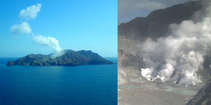
Whakaari/White Island photos taken during September 2021 show how ash can be seen at the active vents, but it’s not visible in the plume above the island
Volcanic ash is typically formed when gas bubbles burst within rising magma. Once the strength of the magma is exceeded by the pressure of the expanding gas, the force shatters the magma into fine particles and propels them into the atmosphere.
Ash is also produced when magma encounters water. The water rapidly heats and turns to steam, and it’s this rapid expansion of water to steam that explosively breaks apart the magma or the surrounding rocks into fine pieces.
The ash we are currently seeing at Whakaari/White Island, however, isn’t a result of either of these processes but from a volcanic process called hydrothermal alteration. This is when rock is softened by the percolation of acid gases and water through it. This is happening at the active vent, where we’ve observed high energy emissions of hot gas which is slowly eroding the vent walls. This eroded rock material (small volumes of ash) is carried in the steam and gas plume from the active crater. So, these ash grains are slowly reworked material, not fragmented parts of the magma coming from depth or the surrounding rocks.
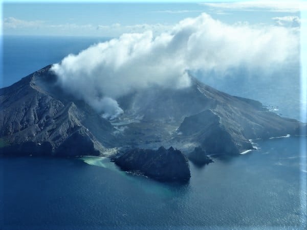
Minor ash emissions are common at Whakaari/White Island and at many other active volcanoes. Our volcano monitoring team has assessed this activity to be consistent with elevated volcanic unrest. As the ash emission is intermittent, minor and lacking the explosiveness of a volcanic eruption, it does not take us across the boundary from Volcanic Alert Level 2 to Level 3 (which is a minor eruption).
At the moment, Whakaari/White Island’s Volcanic Alert Level remains at Level 2 and the Aviation Colour Code remains at ‘Yellow’.
The Volcanic Alert Level reflects the current level of volcanic unrest or activity and is not a forecast of future activity. Eruptions can still occur with little or no warning.
Source : Brad Scott / Geonet / Volcano Information Specialist.
Photos : Geonet.


No comment yet, add your voice below!