
September 30 , 2021.
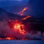
Spain / La Palma , Cumbre Vieja :
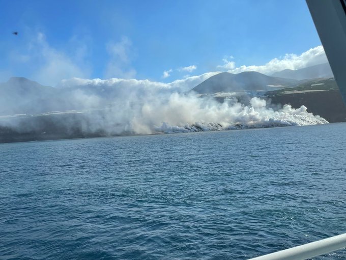
The lava emanating from the eruption of Cumbre Vieja and falling into the sea since last night has created a « huge delta » about half a kilometer wide, while the ocean around it has changed. color due to the effects of volcanic matter. It is only when the volcanic material comes into contact with the sea that small clouds of gas form, which are carried by the wind, but which quickly dilute.
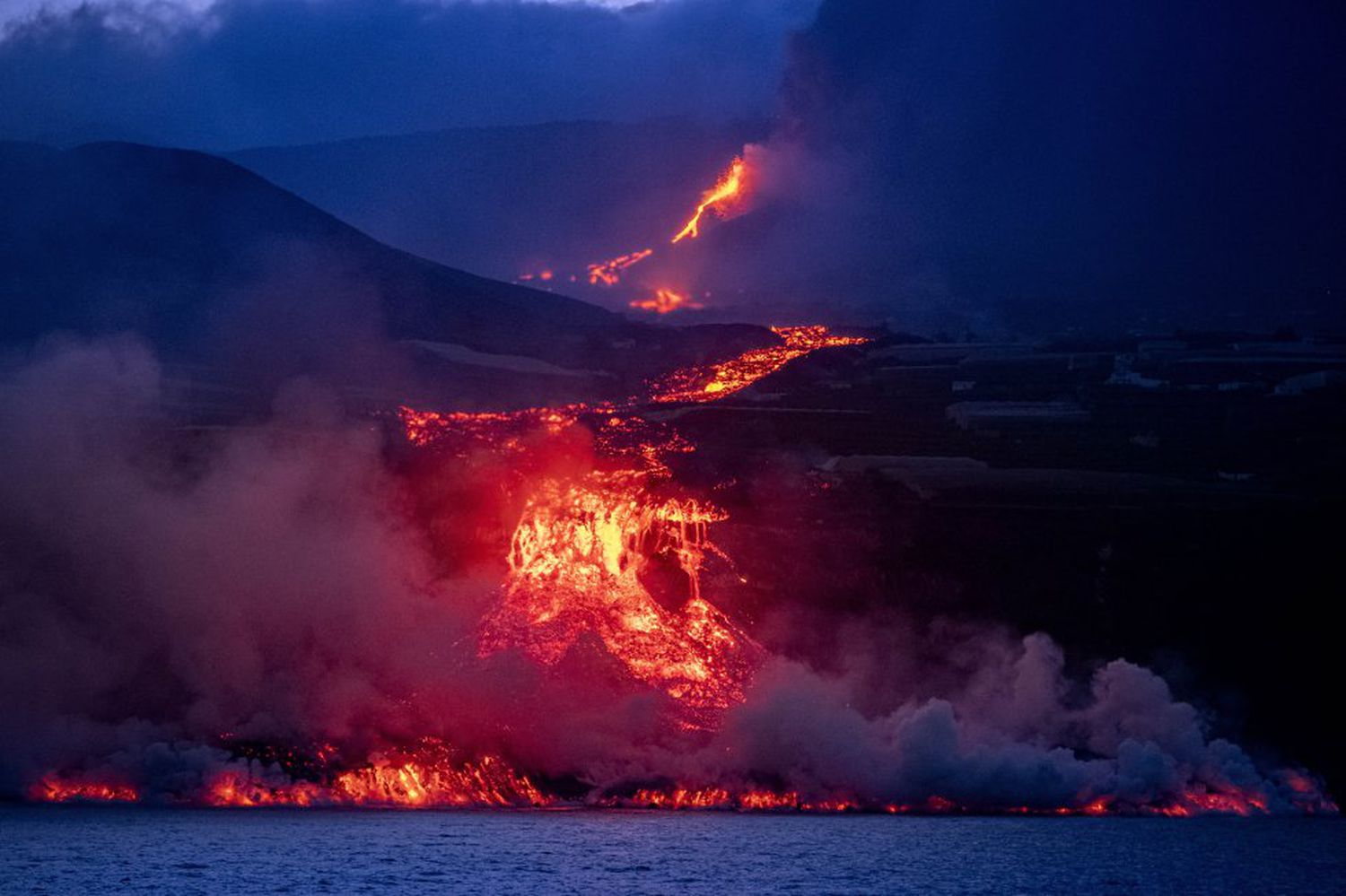
There was also some discoloration of the ocean with areas of turquoise and others brown, especially in the area near the lava. This phenomenon could already be observed 10 years ago during the underwater volcanic eruption of the island of El Hierro, in which the sea was colored with various colors until the eruption of the magma. There was also a small collapse in the area of the cliffs where the lava arrived. From the samples taken before the lava fell into the sea, a chemical, biological and microbiological analysis was made which will be compared to what is obtained « from the first point » and we will know how the ocean behaves in front of. such a phenomenon.
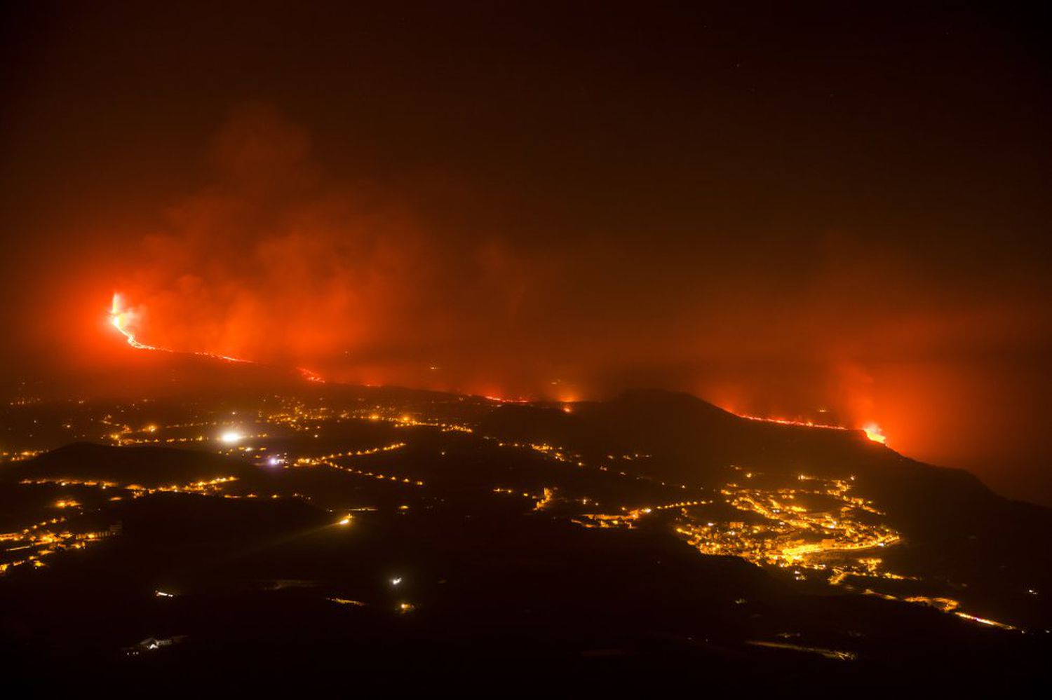
María José Blanco, director of the National Geographic Institute of the Canary Islands (IGN), after the meeting of the scientific committees of Pevolca: “The base of the cliff has created a delta of lava which follows an extension towards the South. From this same area, a cloud of water vapor and other possibly toxic gases is produced which is confined to the area around the lava-sea contact. Although this active flow has reached the sea, the eruptive process continues, and the rest of the flows are practically inactive. The eruptive process could continue to show strombolian activity and the cone could change morphology. The magma destroyed more than 650 buildings during its transit to the sea. The height measured today of the column of ash and gas has reached 3,500 meters above sea level. Regarding the weather conditions, the cloud of ash and sulfur dioxide emitted will move to the northwest of the volcano due to the turn of the wind.
09/29/2021 2:00 p.m. UTC.
Eruptive activity continues on La Palma
Since the announcement the day before, 21 earthquakes have been located on the island of La Palma, between 9 and 14 km deep in the same area where the intrusion began on September 11. The maximum recorded magnitude is M3.3 (mbLg) corresponding to 4 earthquakes, including one felt by the population with a maximum intensity of III in the epicentral zone.
The average amplitude of the volcanic tremor has remained very stable over the last 24 hours in all the stations of the island, within a range of medium-low values compared to the values observed since the start of the eruption.
The island’s network of permanent GNSS stations shows slight elevation and deformation to the southwest at station LP03 and to a lesser extent at LP04.
This morning, due to the decrease in the height of the eruptive column, the IGN issued a new VONA (Volcano Observatory Notice for Aviation) message communicating the current height of the column of 3,500 m above the level of the sea.
Lava from the Cumbre Vieja volcano has started to gain ground on the sea to form a delta about 500 meters wide and, for now, the wind maintains the column of water vapor and possibly toxic gases generated by the contact between the magma and the ocean. Just in case, and until there are definitive results of an emitted gas monitoring study, the containment of the population of the neighborhoods of San Borondón, Marina Alta, Marina Baja and La Condesa, as well as the exclusion of the two-mile zone navigation is maintained.
Scientists monitoring the volcano’s activity do not see evidence that the dynamics of the eruptive process are stable. The eruption is not « stabilized » and there is a dynamic « that is beyond our control, » admitted Rubén Fernández, technical director of the Canary Islands Volcanic Emergency Plan (Pevolca).
Sources : El Pais , IGNes ,
Photos : Arturo Rodriguez /El Pais , IEOoceanografia , Samuel Sanchez /El Pais.
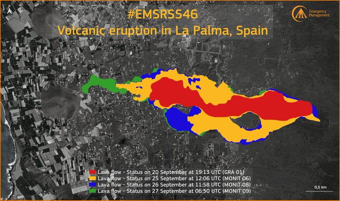
Carte : Copernicus.
Hawaii , Kilauea :
VOLCANO OBSERVATORY NOTICE FOR AVIATION (VONA)
Issued: September 30 , 2021
Volcano: Kilauea (VNUM #332010)
Current Color Code: RED
Previous Color Code: ORANGE
Source: Hawaiian Volcano Observatory
Notice Number: 2021/H262
Volcano Location: N 19 deg 25 min W 155 deg 17 min
Area: Hawaii
Summit Elevation: 4091 ft (1247 m)
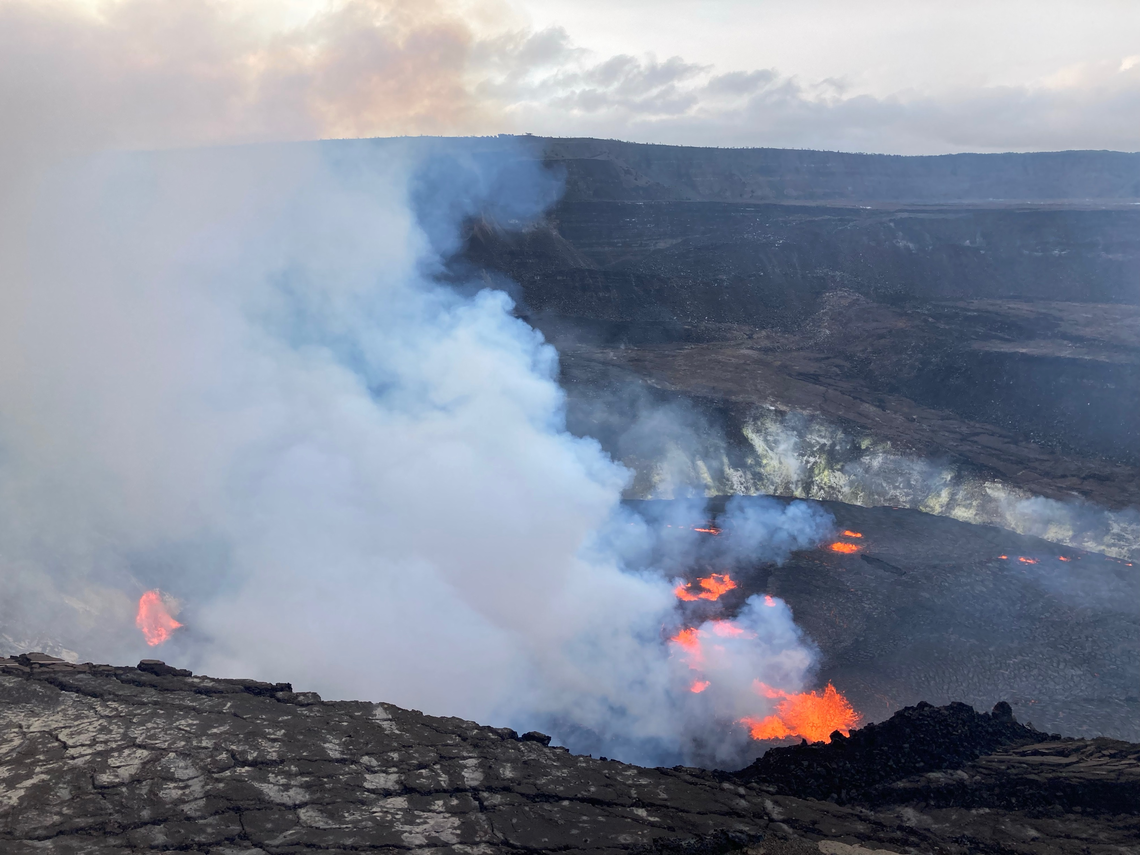
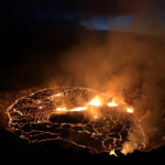
At approximately 3:20 p.m. HST on September 29, 2021, an eruption began within Halemaʻumaʻu crater in Kīlauea’s summit caldera, within Hawai‘i Volcanoes National Park. Fissures opened to the east of the large island within the lava lake that was active in Halemaʻumaʻu crater from December 2020 until May 2021, and are generating lava flows on the surface of the older lava lake. At approximately 4:43 p.m. HST, another vent opened on the west wall of Halemaʻumaʻu crater, and is visible in the left side of this image.
Volcanic Activity Summary:
Kīlauea volcano is erupting. At approximately 3:20 p.m. HST on September 29, 2021, the USGS Hawaiian Volcano Observatory (HVO) detected glow in Kīlauea summit webcam images indicating that an eruption has commenced within Halemaʻumaʻu crater in Kīlauea’s summit caldera, within Hawai‘i Volcanoes National Park. Webcam imagery shows fissures at the base of Halemaʻumaʻu crater generating lava flows on the surface of the lava lake that was active until May 2021.
The US Geological Survey Hawaiian Volcano Observatory (HVO) is elevating Kīlauea’s volcano alert level to from WATCH to WARNING and its aviation color code from ORANGE to RED as this new eruption and associated hazards are evaluated. The activity is confined to Halemaʻumaʻu and the hazards will be reassessed as the eruption progresses.
The opening phases of eruptions are dynamic and uncertain. HVO continues to monitor the volcano closely and will report any significant changes in future notices.
Source : HVO.
Photo : USGS
Indonesia , Bromo :
PVMBG reported that during 21-27 September white gas-and-steam plumes rose as high as 400 m above the rim of Tengger Caldera’s Bromo cone and drifted SW, W, and NW. White-and-gray plumes rose as high as 500 m during 22-23 September. A weak thermal anomaly was visible in Sentinel-2 infrared satellite images on 22 and 27 September. The Alert Level remained at 2 (on a scale of 1-4), and visitors were warned to stay outside of a 1-km radius of the crater.
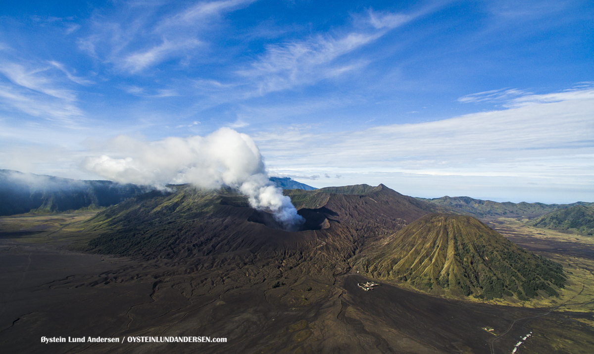
The level of activity is level II (WASPADA) since October 20, 2016. Mount Bromo (2329 m above sea level) erupts intermittently.
The volcano is clearly visible until it is covered in fog. The observable smoke from the crater is white with low to medium intensity, rising about 50-300 meters from the summit. The weather is sunny to cloudy, the wind is weak to the southwest and west. The air temperature is around 12-25 ° C.
According to the seismographs of September 29, 2021, it was recorded:
1 distant tectonic earthquake
Continuous tremor, amplitude 0.5-1 mm (mainly 0.5 mm).
Sources : GVP , PVMBG.
Photo : Oystein Lund Andersen.
Japan , Suwanosejima :
JMA reported that the number of explosions per day at Suwanosejima’s Ontake Crater had increased on 16 September and remained elevated through 27 September. A total of 105 explosions were recorded during 20-27 September. Eruption plumes mainly rose as high as 2.9 km above the crater rim and material was ejected as far as 800 m away from the crater. Ashfall was reported in Toshima village (4 km SSW). Notably, an explosion at 23h49 on 20 September ejected material as far as 1.2 km SE. At 07h11 on 26 September an eruptive event produced a plume that rose 5.4 km; weather clouds prevented confirmation of ejected bombs, but a large amount of ash fell in Toshima village. The Alert Level remained at 3 and the public was warned to stay 2 km away from the crater.
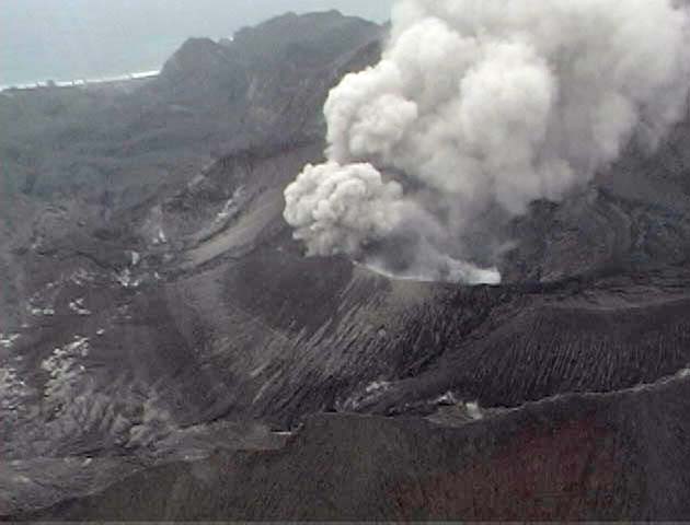
The 8-km-long, spindle-shaped island of Suwanosejima in the northern Ryukyu Islands consists of an andesitic stratovolcano with two historically active summit craters. The summit is truncated by a large breached crater extending to the sea on the east flank that was formed by edifice collapse. Suwanosejima, one of Japan’s most frequently active volcanoes, was in a state of intermittent strombolian activity from Otake, the NE summit crater, that began in 1949 and lasted until 1996, after which periods of inactivity lengthened. The largest historical eruption took place in 1813-14, when thick scoria deposits blanketed residential areas, and the SW crater produced two lava flows that reached the western coast. At the end of the eruption the summit of Otake collapsed forming a large debris avalanche and creating the horseshoe-shaped Sakuchi caldera, which extends to the eastern coast. The island remained uninhabited for about 70 years after the 1813-1814 eruption. Lava flows reached the eastern coast of the island in 1884. Only about 50 people live on the island.
Source : GVP.
Photo : eri-u-tokyo.ac.jp
Saint Vincent , Soufrière Saint Vincent :
La Soufrière Volcano – SCIENTIFIC UPDATE 28/09/21 1:00PM
-Seismic activity at La Soufrière, St Vincent has remained low since the tremor associated with the explosion and ash venting on 22 April.
-Current activity is consistent with a period of unrest after an eruption. This can continue for weeks to months. While volcanic activity has been on a decline, there is the continued presence of near surface hot spots, daily seismic activity and persistent degassing.

– Measurements of the sulphur dioxide (SO2) flux at La Soufrière were carried out by boat off the west coast on 23rd September, with the assistance of the coast guard. Several traverses were completed and yielded an average SO2 flux of 176 tons per day.
-Three lahar signals were observed between 26 – 27 September.
– There is a small, but not insignificant, possibility that magmatic activity might restart, should there be an influx of new magma from depth.
– The volcano is at alert level YELLOW.
Source : UWI
Photo : Nemo.


No comment yet, add your voice below!