
September 29 , 2021.
Spain / La Palma , Cumbre Vieja :
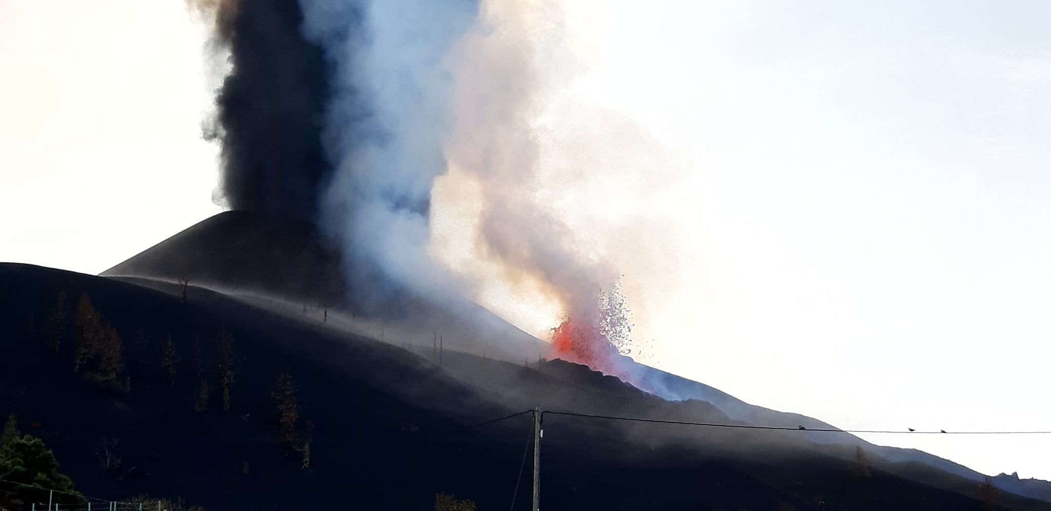
September 28, 2021 12:00 UTC. Eruptive activity continues on La Palma.
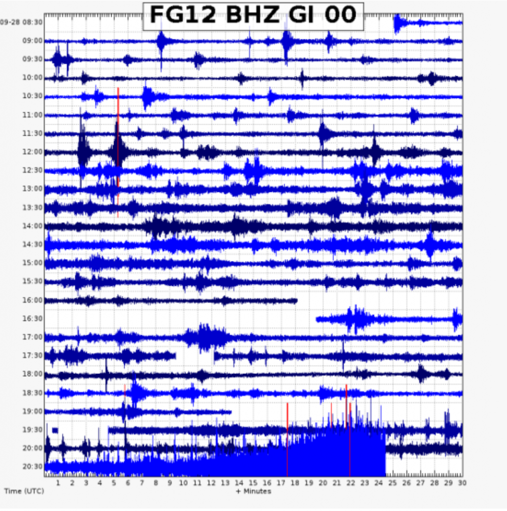
Since the last declaration, 6 earthquakes have been located in the area affected by the volcanic reactivation of Cumbre Vieja, the maximum magnitude recorded is 2.9 (mbLg) and corresponds to an earthquake 10 km deep at 08:35 UTC this morning.
The average amplitude of the volcanic tremor remained at very low values for this eruption until 3:00 p.m. UTC yesterday and practically zero between 3:00 p.m. and 5:00 p.m. UTC. From that point on, it started to increase dramatically, reaching an average range around 19:00 UTC, remaining stable until now.
The island’s network of permanent GNSS stations shows deformation stability. Likewise, the results obtained by InSAR do not reflect a significant variation between the Sentinel1 images of September 22 and 28.
This morning, due to the increased explosive eruptive activity of the eruption, IGN issued a new VONA (Volcano Observatory Notice for Aviation) message communicating the increase in ash emission, as well as the increase in the height of the cloud, which reached 7000 m in height. This VONA was sent, in accordance with the protocols of the International Civil Aviation, to the VAAC (Volcanic Ash Advisory Center) of Toulouse, to the ACC Canarias (Area Control Center) and to the AEMET (State Meteorological Agency).
IGN continues to monitor activity, having strengthened its presence on the island, where the CAVE (Center for Attention and Monitoring of Eruptions) has been established and works daily to collect samples of volcanic material for analysis. in situ and posterior.
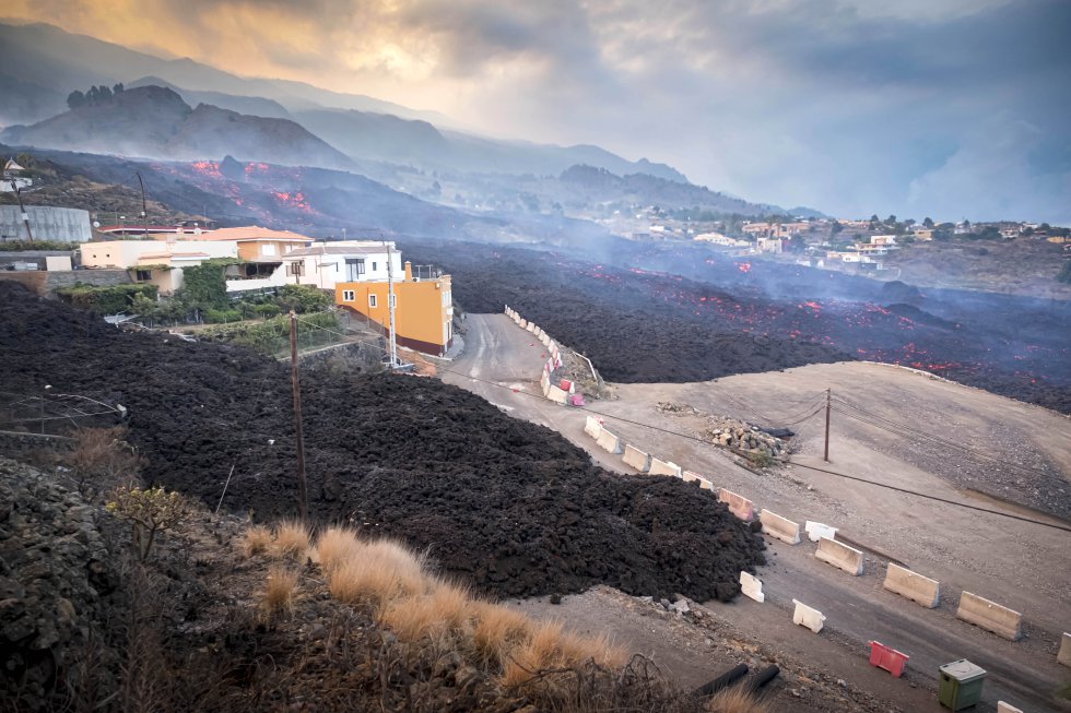
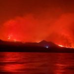
A new lava flow formed further north of the two main ones is heading towards the sea in La Palma since 2:45 am, said Raul Perez, a geologist at the Geological and Mining Institute of Spain (IGME) on Tuesday. This new flow features faster and more fluid lava, which is unique to Hawaiian activity. Maria José Blanco, director of the Canary Islands National Geographic Institute (IGN), explained that the volcano simultaneously exhibits Strombolian and Hawaiian behavior, but the latter currently predominates. The casting is already at a distance of between 800 and 1,000 meters from the sea, according to the Department of Homeland Security. « The lava is at least 1000 meters from the coast of Tazacorte, » said Miguel Angel Morcuende, technical director of the Canary Islands Volcanic Risk Prevention Plan (Pevolca). On the way to the sea, the magma burns plastic from greenhouses and fertilizers, which are explosive. At around 1 p.m., a cloud containing toxic elements could be observed over the El Pampillo area. This toxic cloud, already diluted, caused no harm or danger to people since it remained in the exclusion zone. Firefighters from the Puntagorda Forestry Brigade, who were intervening in the area, had to leave the area as a matter of urgency.
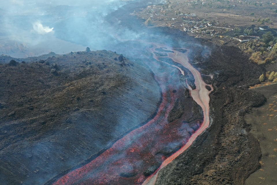
The path of the lava flow to the sea remains unknown to scientists. « We currently do not have the scientific or technical possibility to set a date or time of arrival at sea, » said Pevolca technical director Miguel Angel Morcuende. The lava flow is moving about 300 meters per hour.
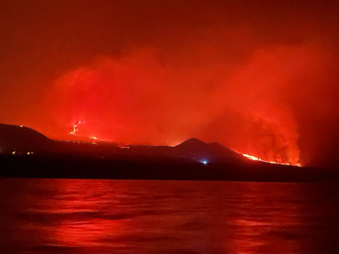
September 29, 2021. Lava from the La Palma volcano reached the sea around midnight (Spanish Peninsula time, 11 p.m. in the Canaries), ten days after the eruption began on September 19. The flow began to flow into the ocean in the area known as Playa de los Guirres, by an area of cliff about 100 meters high, witnesses of the event and the mayor of Tazacorte Juan Miguel Rodriguez confirmed this. The entrance of the glowing mass into the sea caused intense fumes of black and white smoke and the water to boil, as seen from the boats monitoring the progress of the flow.
The National Geographic Institute recorded a magnitude 3.3 earthquake located southwest of Villa de Mazo, La Palma.
The movement took place at 11:19 p.m. local time and was located 11 kilometers deep.
This is one more seismic movement than those recorded in recent days, most of them located in the municipality of Fuencaliente.
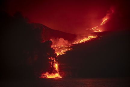
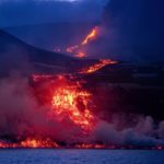
The lava creates a « pyramid » 50 meters high at the foot of the cliff.
The lava that falls at the foot of the coastal cliff from a height of about 100 meters comes from the southern slope of the volcano La Palma. « An impressive deposit over 50 meters high is forming in this area of contact with the sea, » according to the Marine Geosciences Group of the Spanish Institute of Oceanography. The darkness of the night makes it impossible to see the columns of water vapor formed by the thermal shock of the lava with the sea, columns that carry gases that can be toxic to the eyes, lungs and skin.
Source : IGNes , El Pais ,
Photos : INGV , El Pais / Rafa Avero , INGV , Capitanía Marítima DGMM , Arturo Rodríguez .
Italy / Sicily , Etna :
Weekly Bulletin from September 20, 2021 to September 26, 2021 (issue date September 28, 2021)
SUMMARY STATEMENT OF ACTIVITY
In view of the monitoring data, it is highlighted:
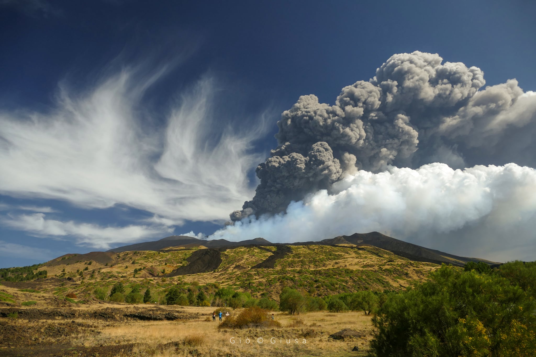
1) VOLCANOLOGICAL OBSERVATIONS: Activity of lava fountains at the Southeast Crater, and degassing at the other summit craters.
2) SEISMOLOGY: Low fracturing seismicity. Average amplitude of the volcanic tremor with very high values during the lava fountain of September 21 and low values in the remaining period.
3) INFRASOUND: Moderate infrasound activity
4) DEFORMATIONS: During the last week, no significant deformation of the ground was observed, with the exception of the variations measured by the inclinometric network during the lava fountain of September 21, 2021.
5) GEOCHEMISTRY: SO2 flux at an average level, with high values in conjunction with the lava fountain
The flow of CO2 emitted by the soils is presented on average, decreasing values.
The partial pressure of CO2 dissolved in water shows no significant change.
The helium isotope ratio appears on medium-high values with a slight increase (latest data from 08/31/2021).
There are no updates for the C / S report.
6) SATELLITE OBSERVATIONS: The thermal activity in the summit area was at a high level in correspondence with the lava fountain of the Southeast Crater on September 21, 2021.
VOLCANOLOGICAL REMARKS
During the week, the monitoring of the volcanic activity of Etna was carried out by analyzing the images of the surveillance cameras of the INGV, Osservatorio Etneo (INGV-OE)
and by two inspections in the summit area by INGV staff on September 21 and 24. Overall, the state of activity of the summit craters consisted of a variable degassing regime of all the craters and interrupted by a lava fountain produced by the Southeast Crater on September 21.
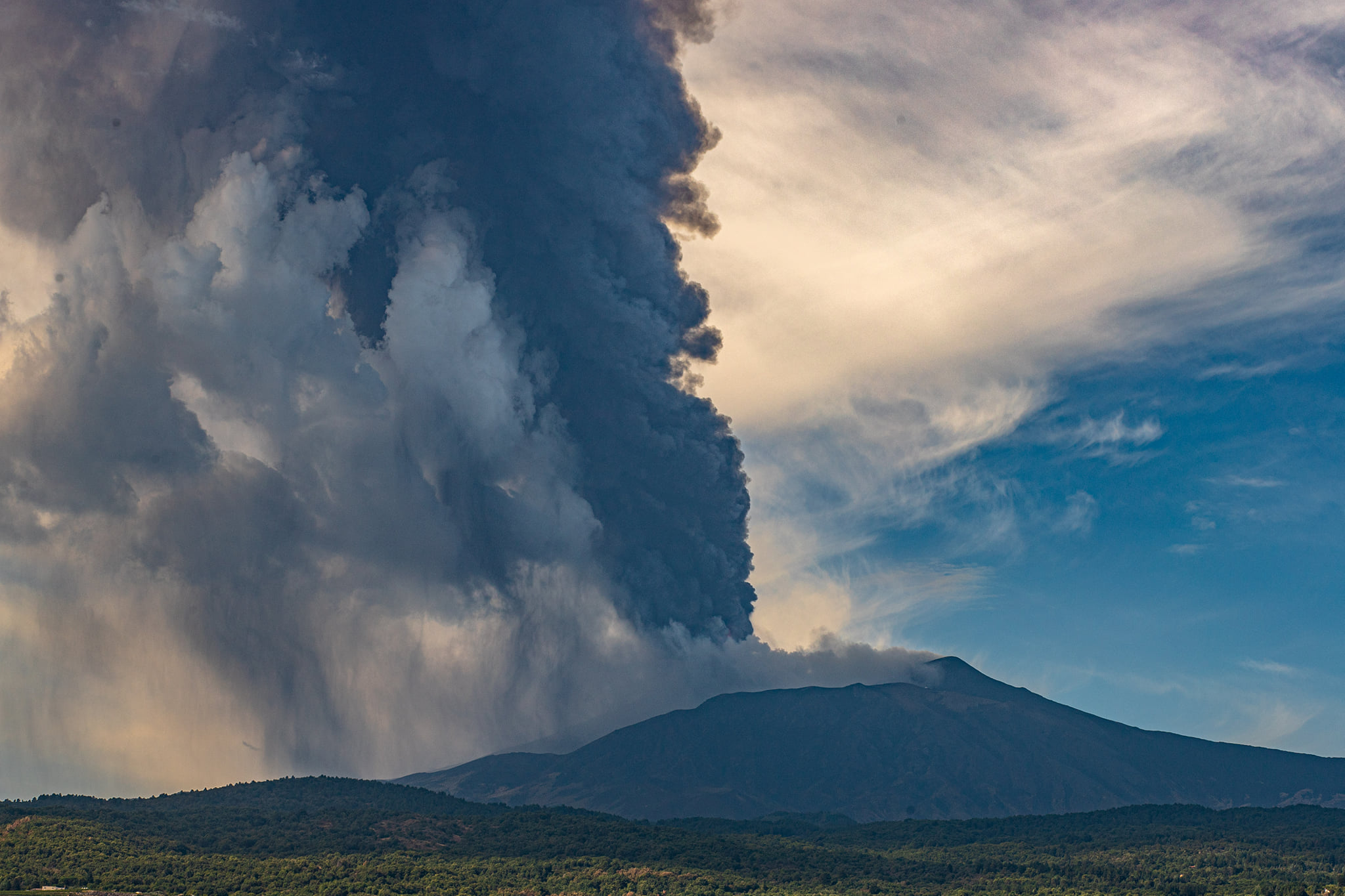
In particular, the Southeast Crater, after a fairly quiet period, subsequent to the lava fountain on August 29, suddenly returns to activity on September 21, fueling a new lava fountain event. Activity begins at ~ 06:15 GMT (all hours are in GMT) fueling explosive Strombolian activity that gradually and steadily evolved into the lava fountain stage at ~ 07:55, and ended at 09:25 . During the eruptive event, a lava flow was produced which propagated along the northern flank of the cone of the Southeast Crater in a southwest direction, channeled between Mount Barbagallo and Mount Fumento Supino. The feeding of the lava flow ends a few hours after the conclusion of the fountain phase with the lava front stopping at an altitude of ~ 2720 meters above sea level. The eruptive activity of the fountain produces a coherent eruptive cloud which rose to an altitude of ~ 8000 meters with a surface dispersion mainly in the eastern sector of Etna and fallout of matter (lapilli and ash) in the agglomerations. downwind of this slope (eg Zafferana, Milo and Fornazzo, Riposto, Giarre and Mascali,).
Regarding the other craters, during this period, they showed degassing at a variable rate mainly from the Bocca Nuova and secondarily from the Nord-East Crater. Finally, the Voragine crater was characterized by fumarolic degassing.
Source : INGV.
Photos : Gio Giusa. Guide Alpine Vulcanologiche Etna .
Italy , Stromboli :
Weekly Bulletin from September 20, 2021 to September 26, 2021 (issue date September 28, 2021)
SUMMARY STATEMENT OF ACTIVITY
In view of the monitoring data, it is highlighted:
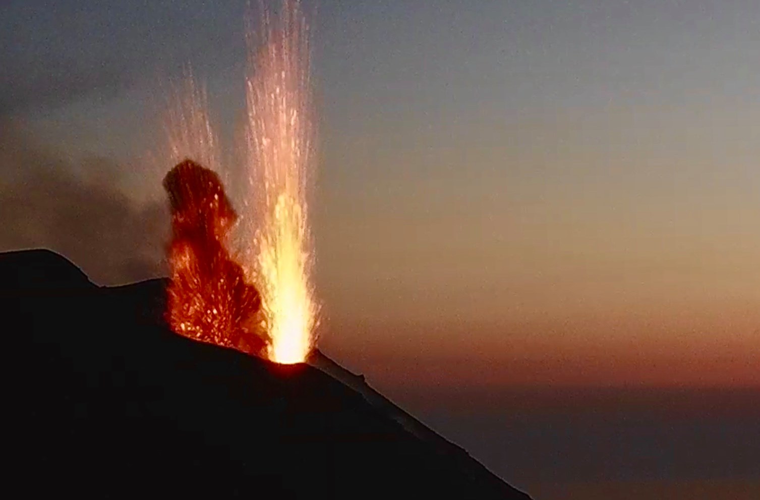
1) VOLCANOLOGICAL OBSERVATIONS: During this period a normal explosive activity of strombolian type was observed. The total hourly frequency of explosions fluctuated between medium-low and medium values (7-15 events / h). The intensity of the explosions varied from low to high in both the North Crater area and the Center-South area.
2) SEISMOLOGY: The seismological parameters monitored do not show significant variations.
3) DEFORMATIONS: The island’s soil deformation monitoring networks have not shown any significant changes over the past week. The inclinometric network showed small « level variations » at the Timpone del Fuoco station on September 20 and 26, 2021.
4) GEOCHEMISTRY: The flow of SO2 at a medium-low level
The flow of CO2 from the ground to the Pizzo Sopra la Fossa is at an average level.
The weekly average C / S ratio is at high values (C / S = 18.0).
The isotopic ratio of Helium dissolved in the thermal aquifer (latest data dated 9/21/2021) is at high values.
5) SATELLITE OBSERVATIONS: The thermal activity in the summit area is at a low level.
VOLCANOLOGICAL REMARKS
During the observation period, the eruptive activity of Stromboli was characterized thanks to the analysis of the images recorded by the surveillance cameras of the INGV-OE (altitude 190m, Punta Corvi, altitude 400m and Pizzo). The explosive activity was mainly produced by 3 (three) eruptive chimneys located in the area of the North crater and by 6 (six) eruptive chimneys located in the area of the Center-South crater. All the vents are placed inside the depression which occupies the terrace of the crater.
Description of the eruptive activity of surveillance cameras.
The N1 crater located in the North zone, with two emission points, produced low intensity explosions (less than 80 m in height) emitting fine materials (ash) mixed with coarse materials (lapilli and bombs) until to September 23. In the following days, the intensity of the explosions increased, reaching medium to high values (many explosions exceeded 150 m in height). Vent N2 showed low intensity explosive activity (less than 80 m in height) emitting coarse material. The average frequency of explosions varied from 2 to 6 events / h.
In the Center-South zone, sector S1 sporadically showed low-intensity explosive activity emitting fine materials, while the three vents located in sector S2 produced explosions, even simultaneously, of varying intensity from low to high (the products of some explosions exceeded 150 m in height) emitting fine materials (ash) mixed with coarse materials. Sector C produced an intense degassing activity interrupted on September 25 and 26 by modest explosions emitting coarse materials. The frequency of the explosions varied from 3 to 9 events / h.

Description of the eruptive activity from the site inspection in the summit area.
On the morning of September 23, 2021, the technical and scientific teams of I.N.G.V. carried out a survey in the summit area to define the morphological changes and the eruptive style of the mouths of the crater area.
Sector N1 had 4 mouths with a structured cone. The frequency of the explosions was low while the intensity was medium. The material released was mainly ash. Also
sector N2 exhibited a structured cone with a frequency, intensity and type of emitted material similar to sector N1.
Sector C had 2 outlets in degassing / blowing activities.
Sector S1 did not show explosive activity while sector S2 showed 4 mouths, one of which was predominantly puffing / splashing activity. The frequency of explosive events was low, the intensity of the explosions reached medium and sometimes high levels. The material emitted was coarse and a few small intracrater collapses were observed.
Source : INGV.
Photos : INGV.
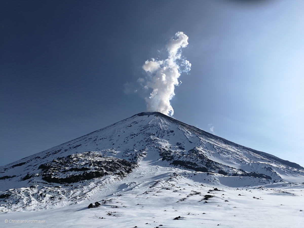
Kamchatka , Klyuchevskoy :
VOLCANO OBSERVATORY NOTICE FOR AVIATION (VONA)
Issued: September 29 , 2021
Volcano: Klyuchevskoy (CAVW #300260)
Current aviation colour code: ORANGE
Previous aviation colour code: green
Source: KVERT
Notice Number: 2021-118
Volcano Location: N 56 deg 3 min E 160 deg 38 min
Area: Kamchatka, Russia
Summit Elevation: 4750 m (15580 ft)
Volcanic Activity Summary:
The activity of the volcano is low. A strong wind raises ash from the slope of the volcano. Satellite and video data by KVERT showed a resuspended ash plume extended to the east of the volcano.
Resuspended ash plumes can be observed at altitudes of 9,800-16,400 ft (3-5 km) a.s.l. Ongoing activity could affect low-flying aircrafts.
Volcanic cloud height:
3000-4000 m (9840-13120 ft) AMSL Time and method of ash plume/cloud height determination: 20210929/0310Z – Video data
Other volcanic cloud information:
Distance of ash plume/cloud of the volcano: 75 km (47 mi)
Direction of drift of ash plume/cloud of the volcano: E / azimuth 91 deg
Time and method of ash plume/cloud determination: 20210929/0145Z – MODIS AQUA (31m32)
Source : Kvert.
Photo : Christian Kirchmayer.
Guatemela , Fuego :
SPECIAL VOLCANOLOGICAL BULLETIN
LAHARES in the SECA, CENIZA, EL JUTE AND LAS LAJAS ravines
The rains at this time in the area of the volcanic complex, currently generate lahars in the Barrancas Seca, Ceniza, El Jute and Las Lajas, tributaries of the rivers Pantaleón, Achiguate and Guacalate, with probabilities of increasing in the next few minutes due rains in the area. The lahars descend carrying fine volcanic material, branches and tree trunks, as well as blocks 30 cm to 1.5 meters in diameter.
The rains of the last few days keep the volcanic deposits saturated with moisture, so the lahars will continue to be generated in the afternoon and at night.
INSIVUMEH maintains visual and instrumental monitoring of volcanic activity through seismic stations, volcano observers and the web camera.
Source : Insivumeh.


No comment yet, add your voice below!